Oroville Dam Drains in The Spillway Walls - How Do They Work?

Status
Not open for further replies.


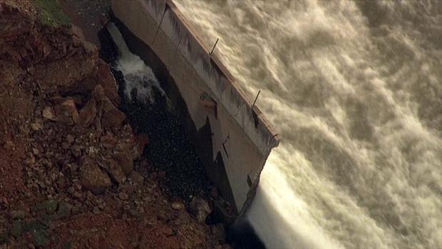
 Particularly for appurtenant structures (such as spillways and outlet works) associated with high velocity, high volume releases, care must be taken so that the drainage system is not subjected to adverse hydraulics, which can damage or fail the appurtenant structure. Two conditions that should be evaluated include: (1) excessive back pressure, which could introduce hydrostatic (uplift) pressure beneath a spillway conveyance feature and/or terminal structure; and (2) stagnation pressure that could be introduced through cracks and/or open joints along a conveyance feature and/or terminal structure, leading to pressurizing the drainage system [42]. In other words, there should generally be no direct path (such as drains, open joints or cracks) through the floor slabs and walls that are subject to high velocity, high volume flow conditions.

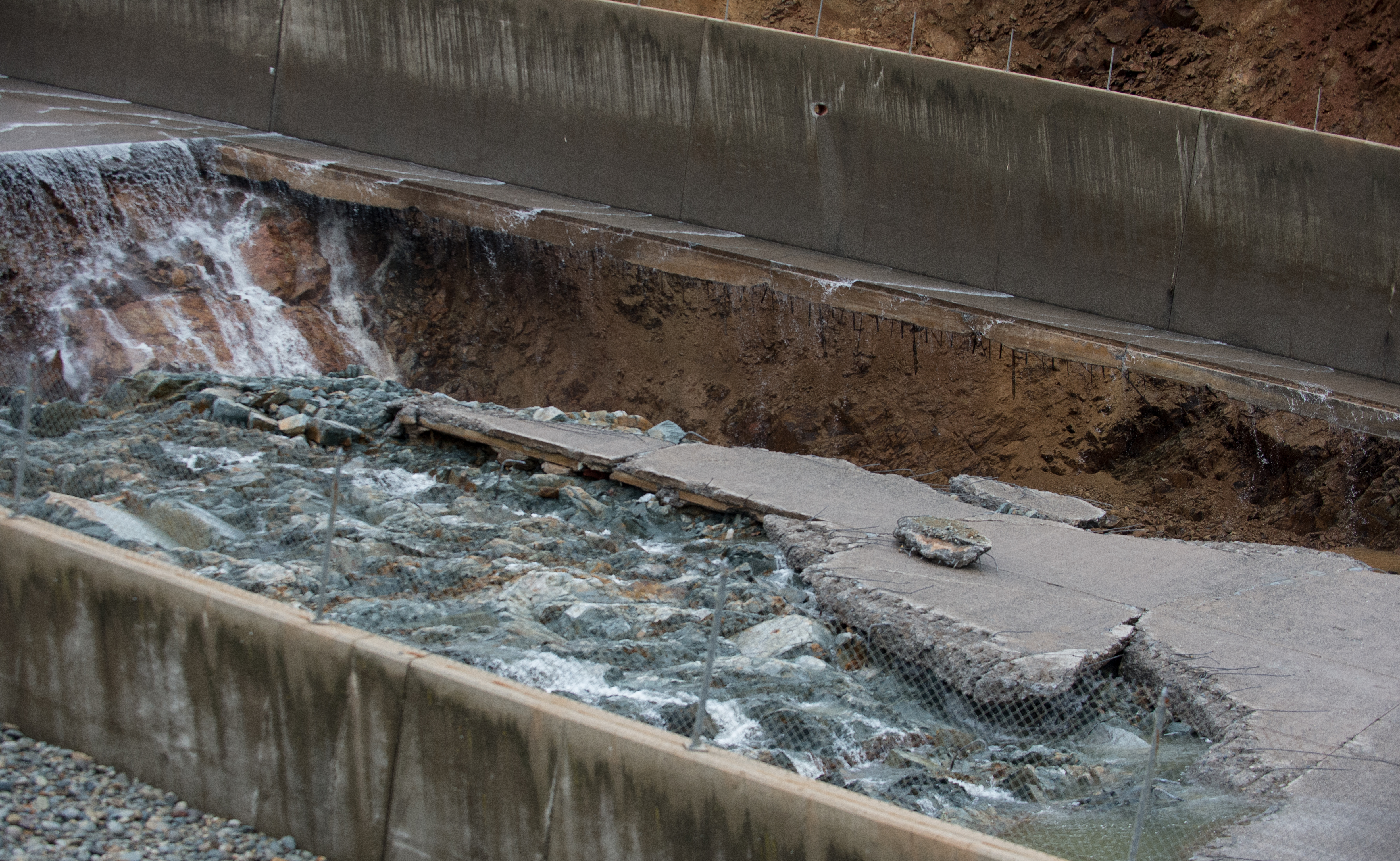
 Air demand must be considered, which could be associated with providing a “vacuum break” to allow air to eliminate lowered pressures induced by high velocity flow across drain outlets (see figure 3.7.3.1-4). Inlets or intakes which provide the air should be located above the maximum tailwater level.

New member, lurking for a week. Great site.

The quoted test text is from post #21 above, the referenced "techreferences" document, page 3-125. There is another similar reference somewhere above or in the original thread that I have not been able to find that shows clear plan views of vented drains.

The first paragraph suggests that the flow of water out of the wall ports might indicate that the flow of water through the slabs to the drains system is excessive which to me suggests that the folks running the dam should have thought about that years ago since even much older photos show large drain flows.

The second paragraph references the need to allow air to bleed into the drains to allow proper water flow.

I believe the yellow arrows point to air vents.
 
The concrete form lines can be seen on this photo. (Anyone able to download the full res photos from DWR? I get a message saying to contact them to download.)
http://pixel-ca-dwr.photoshelter.co...0kN9PORvuykE/KG-oro-spillway-damage-10060-jpg
upload_2017-2-17_17-21-51.png

upload_2017-2-17_17-12-0.png

Assuming those are 4 ft x 8 ft plywood you can use those dimensions to get some accurate scaling.

The sidewall is 20 ft tall (not news, but a verification of my method.) The length of the sidewall section from joint to joint is 52 ft. (seems unusual length). The bottom slab joints align w sidewall joints, so they appear to be 52 ft long also. (We know from the drawings, the channel is 178 ft wide, IIRC.)

The fence post spacing is 10 ft.

That sidewall drain appears larger than 6 inch diameter --
upload_2017-2-17_17-24-39.png


here's the page with the video of this picture

http://www.nbcbayarea.com/news/loca...rops-After-188K-Evacuated-413594893.html?t=28

The outflow shown in this picture appears to be from a pipe larger than 6" as well, perhaps as large as 12".
 
If you inspect the image annotated with yellow arrows starting at the left side image bottom, you see a sequence of discharge port flows as follows:

Strong (starting at the very bottom of the image)
Weak
Strong
Very Strong (adjacent to the area of damage
Weak
Strong (second discharge above the damaged area)

If there was a discharge pipe travelling down-slope along the sidewall, I would expect there to be a constant or increasing head the further down-slope the water traveled. Since there is significant variation in the strength of the discharge streams, this suggests there is no lateral connector running down-slope providing a common discharge rail.

The evidence in the image tends to support a series of individual drain lines running diagonally down from the centre of the slab, making a 45 degree down-slope turn beneath the inspection port fitting, and then running down to another 45 degree turn into the discharge port. One of the other pictures of sidewall damage showed a clear image of a 45 degree elbow attached to the exterior of the the sidewall (cannot find that image).

EDIT

Found the image. I believe it is from the right sidewall adjacent to the area of damage. Is

most easily seen when image magnified.
Much of possible interest in this picture...

upload_2017-2-17_17-44-39.png

The footer varies significantly in width (thin arrows), to the extent that the long bolts(?) at bottom left lie along the side of the footer instead of going through the footer (circled in yellow). Seems odd. Indicative of sloppy work // poor quality control? You might reasonably expect the footer form to wander, but how would the bolts miss the footer?

Also note the periodic cutouts (big arrows). If there really are pipes running under slab and feeding the side drains, at some point they would need to turn the corner from under the slab to along the outside. Are these cutouts where that happens?
 
Went digging for older images to see if the high drain volume is new. High drainage has been present since 2011, maybe longer.

Good quality image at www.chicoer.com 3/25/2016 shows drains operating (spillway, upstream lookers right drains). I could not extract exif data so used date in the URL. Flow was ~6kcfs on this date, and 0 during daylight hours on previous few days.
http://www.chicoer.com/apps/pbcs.dl...NEWS&ArtNo=324009997&Ref=PH&Profile=1030040#7

Low quality image here, if you zoom in and squint, it looks like the drains are running on 3/21/3011 (spillway, upstream lookers left, 2 drains barely visible near top where it steepens). Image Exif timepstamp is March 20, 2011 9:56:20AM, no timezone. Flow was ~30kcfs at this time.
Terribly clunky website, imho. Click at risk to your web design sense.
http://mapio.net/pic/p-49759579/
I extracted this image url and used an exif viewer to get the timestamp http://static.panoramio.com/photos/original/49759579.jpg

Flows from
http://cdec.water.ca.gov/jspplot/js...16+18:35&geom=small&interval=5&cookies=cdec01
and
http://cdec.water.ca.gov/jspplot/js...11+18:35&geom=small&interval=2&cookies=cdec01

To mods, re no-click. These images aren't mine, or the government's, so I do not feel comfortable copying them, hence the links.

EDIT to add: The outflow plots (sensor 7858) appear to include additional flows other than the spillway. Looking at different dates, there is often non-zero outflow, yet the Chicoer article says this was the first release in 5 years. Likely the other outlets (powerhouse, etc) are included in sensor 7858 outflow.
 
Last edited:
I can tell you these drains are typical in concrete spillways and they drain the water that seeps under the slab or behind the walls. Modern designs try to minimize this, and you would expect only a trickle. The discharge ports are elevated above spillway flow so there is no backflow.

I would be concerned with the amount of flow, because that means significant head loss in the drain pipe. Wherever the water source originates, water pressure is significantly higher than the discharge point. Also, typical designs would have gravel around a perforated pipe as the intake. This much water could indicate that gravel is gone and/or there are voids under the slabs or walls.
Question (and mods feel free to delete if addressed elsewhere) - other posters have stated, and this photo seem to show, that drains are not installed in the spillway section just downstream of the gates. I am thinking, in my non-expert way, that this area is the last area where a failure of the deck should occur, and it too should have drains for under-deck protection.
 
retired, I would be very surprised if there was no drainage below the deck there. However, given the gentle slope of the spillway in that section, it isn't until significantly downslope that the drains can exit at the height that they exit. They want the exit holes to be high enough that water doesn't flow into them.

Just a guess, but I think a reasonable explanation.
 
Speaking of the drainage system, page 133 of: https://ia800302.us.archive.org/3/i...lirich/zh9californiastatew2003calirich_bw.pdf says:

Drain System.
The foundation drains designed
for the spillway included nearly vertical NX holes
drilled 65 feet into the foundation rock of headworks
Monoliths 25 and 26 and extensive perforated pipe
systems on the foundation surface under the headworks,
chute, and higher portions of the emergency
spillway weir. Much of the drain system on the foundation
surface was modified during construction.
The original 4-inch-diameter, horizontal, pipe
drains under the chute were redesigned in accordance
with a recommendation from the Oroville Dam Consulting
Board. The pipes were placed on a herringbone
pattern to give them a downward slope and
enlarged to a 6-inch diameter. The longitudinal collector
system was enlarged proportionally and modified
slightly. The effect of these modifications was to increase
the system's capacity and its self-cleaning ability.
The pipes remained on the foundation enveloped
in gravel which projected into the reinforced-concrete
floor of the chute.

Similar drain pipes were impractical to place on
irregular rock surfaces under the headworks and
emergency spillway weir. The contractor was allowed
to substitute wooden formed drains of equal cross-
133
sectional area. These forms were cut to fit the irregular
rock surface and remained in place after the concrete
was placed over them.
Content from External Source

Aaron Z

It is a bizarre situation, and obviously frustrating for the posters on this forum (such as myself), that drawings that detail the specific installed spillway drainage system for this site are not yet in the public domain. The drainage system is a "critical safeguard" for this dam and presumably for other similar dams. I know a lot of effort has gone into locating the drawings (thanks to the all the forum contributors!). It is strange that other drawings have been found, but not these. As a result a good portion of this thread has gone into speculation as to location, purpose, geometry, configuration, materials of construction, installation procedures, etc - all of which would not be required if we had drawings. I think and hope that the authorities have the drawings (as-built) - and when all the investigations are finished, the drawings (and operating/maintenance manuals and inspection data) will ultimately find their way to the public domain.

To provide perspective, in an oil refinery in the US (where I obtained experience in process safety concepts), key data on critical safeguards is classified as "process safety information", and by law the owner/operator is mandated to have this data both accurate and updated.

I'll wager that 30 minutes after the spillway failure occurred, the DWR people had the drawings of the drainage system pulled up on every computer in the office, and they were all pondering the very same questions we are today.
 
retired, I would be very surprised if there was no drainage below the deck there. However, given the gentle slope of the spillway in that section, it isn't until significantly downslope that the drains can exit at the height that they exit. They want the exit holes to be high enough that water doesn't flow into them.

Just a guess, but I think a reasonable explanation.

Yes, I am about 95% sure this is the explanation. The drains are gravity flow, and the discharge ports are raised so you can observe discharge for cloudiness (soil piping) and flowrate and also to prevent backflow when you are at spillway design flow. To accomplish this, any given drain collector under the slab must be pipe downstream and discharge high on the wall.

There is good evidence, imo, that the whole network is connected, because the outlet ports are regularly spaced, and photos show that once the spillway broke, the series of outlet ports downstream shut off.

The thing to keep in mind is that the source of flow observed in these drains is upstream of the discharge point, possibly significantly upstream if the drains are a connected network.

Thanks for the explanation guys. But couldn't the drain pipes in the area be configured so the pipe discharged above the wall, and by use of vertical extension of the pipe and a 90 elbow, so the the water still lands inside the spillway? Also, if the under-slab piping is present in this area, it still needs to be vented somehow to prevent potential uplift. Where would the first vent location be? Apologies if I'm missing something obvious - open channel flow is not in the realm of experience for most mechanical engineers...


here's the page with the video of this picture

http://www.nbcbayarea.com/news/loca...rops-After-188K-Evacuated-413594893.html?t=28

The outflow shown in this picture appears to be from a pipe larger than 6" as well, perhaps as large as 12".

In the text description of the "herringbone pattern," they are referring to the pipes under the spillway slab. The size of these pipes are what matter to the people concerned with seepage under the spillway. These 6" pipes would feed a collector that would be sized larger and is routine design based on the number of seepage collection pipes and their size. The discharge pipes may well be 12" or so.
 
Thanks for the explanation guys. But couldn't the drain pipes in the area be configured so the pipe discharged above the wall, and by use of vertical extension of the pipe and a 90 elbow, so the the water still lands inside the spillway? Also, if the under-slab piping is present in this area, it still needs to be vented somehow to prevent potential uplift. Where would the first vent location be? Apologies if I'm missing something obvious - open channel flow is not in the realm of experience for most mechanical engineers...

Vertical pipes would be a poor design. They pipes must be designed to carry some sediment. Sediment accumulation could clog the pipe. Good design practice is to have positive gravity drainage through the whole network to move any sediment.

Regarding venting: the whole purpose of the pipes is to move the water from under the spillway so there is minimal pressure. There is typically no venting for the slab area. The collector pipes may be vented for hydraulic reasons.
Thanks! Your comment on sediment makes perfect sense.

My concern regarding vents was regarding venting of the collector pipes where adjacent to the slab (outside the spillway wall). Apologies for not making this clear. Without vents, the piping network can still build up significant head (due to elevation change of the deck), and that head can cause uplift under the deck. Perhaps the slab in this area is designed for this uplift? Or perhaps I am still missing something...
 
Thanks for the explanation guys. But couldn't the drain pipes in the area be configured so the pipe discharged above the wall, and by use of vertical extension of the pipe and a 90 elbow, so the the water still lands inside the spillway? Also, if the under-slab piping is present in this area, it still needs to be vented somehow to prevent potential uplift. Where would the first vent location be? Apologies if I'm missing something obvious - open channel flow is not in the realm of experience for most mechanical engineers...
If everything is functioning as designed, there's essentially zero pressure in the drainage system (or at least that's my guess). With a vertical pipe there, you'd end up with a lot of stationary water in it with no way out unless you installed some sort of pump.

The drainage pipes are below the (18"?) slab. They then have to take a slight downhill slope (so the water will flow), and can't exit until that slight slope is far enough above the slab. That's why the first exits are significantly down the spillway from the crest.
 
Thanks! Your comment on sediment makes perfect sense.

My concern regarding vents was regarding venting of the collector pipes where adjacent to the slab (outside the spillway wall). Apologies for not making this clear. Without vents, the piping network can still build up significant head (due to elevation change of the deck), and that head can cause uplift under the deck. Perhaps the slab in this area is designed for this uplift? Or perhaps I am still missing something...
There appear to be vertical vents behind the walls near the outlets into the spillway.
 
Thanks! Your comment on sediment makes perfect sense.

My concern regarding vents was regarding venting of the collector pipes where adjacent to the slab (outside the spillway wall). Apologies for not making this clear. Without vents, the piping network can still build up significant head (due to elevation change of the deck), and that head can cause uplift under the deck. Perhaps the slab in this area is designed for this uplift? Or perhaps I am still missing something...

The whole purpose is to prevent uplift and get the hydraulic pressure under the slab to near zero. Of course to need some head to overcome friction losses in the pipe as you move water out, but that's your target. If you are speaking of water accumulating in the discharge pipe and backing up head, I would say the flowing discharges on the spillway are the "vents" to relieve the water.

My concern is with the amount of water, and that is perhaps what you are talking about as well. It looks to me that these pipes are flowing at or near hydraulic capacity (more than the designers intended), so indeed there may be uplift pressure on the spillway somewhere under the slab (more than designed for).

The apparent manholes are also key to me - these indicate the whole system is a big network. I envision a pipe coming out of these manholes to the wall discharge. This pipe is set low in the manhole. Collected seepage from under the slab flows into the manhole via pipe. Set higher in the manhole is a an overflow pipe that goes downhill alongside the wall in case the wall discharge becomes plugged.
Thanks for your response. You have articulated my concern exactly, except your version is much more detailed/useful.
 
Much of possible interest in this picture...

upload_2017-2-17_17-44-39.png

Also note the periodic cutouts (big arrows). If there really are pipes running under slab and feeding the side drains, at some point they would need to turn the corner from under the slab to along the outside. Are these cutouts where that happens?

Trying to corroborate this. Despite looking at the various high-res images of the hole, I cannot find any evidence of pipes under the slab (remnant, twisted, broken pipe, trenches for pipe, cutouts in the concrete slab, etc.) in the damaged area other than what you have noticed. Despite the relatively regular spacing and almost rounded appearance in some cases, these could simply be areas where the concrete was poured over rock and that rock is gone, as this photo seems to indicate to me.


upload_2017-2-18_12-36-55.png
 
Hi, thank you all for the excellent discussion. I'm a newbie here.
Please, excuse my language, I'm not a native English speaker.
There is good evidence, imo, that the whole network is connected, because the outlet ports are regularly spaced, and photos show that once the spillway broke, the series of outlet ports downstream shut off.
That was my conviction all the time... but it's probably wrong.
If a higher drainage section is connected with a lower one, water column pressure inside such network will expel the fluid through all underlying openings, both outlets and "inlets". I.e. wont work.
 
Studied info here with interest. Spillway slab heave from excessive under slab hydrostatic pressure seems reasonable.

The source of the water from the drains, IMO, is from the lake, seeping under the headgate structure into the upper end of the substructure under drain system. Quantity of water in the drains would be a function of lake level and how porous the seal between the structure the structure and the sub grade bedrock is.

It does appear that the under drains protecting the spillway slabs are connected to common drain pipes running downslope on both sides of spillway. It appears that the entire system is carrying a great deal of flow and that would increase the under slab pressure necessary to move water from underneath the slab. A clogged relief drain along the system would further increase the under slab pressure in the vicinity immediately upstream of the clogged relief.

Once under slab hydrostatic pressure heaves the slab upward a few inches, 50000 CFS flowing over the step at supercritical velocities would easily take care of the rest of the destruction.
 

Attachments

  • VI-1-20150610.pdf
    603.8 KB · Views: 1,027
Finally got my download privileges for this photo of the 1968 event where the spillway was running 150,000 cfs:

http://pixel-ca-dwr.photoshelter.co...gQ/NH-Oroville-86-Flood-6590-2-02-21-1986-jpg

Here's a zoom:

upload_2017-2-19_10-57-28.png

Here's a zoom of the same drains form the other day when the spillway was running 100,000 cfs (note perspective is reversed:

http://pixel-ca-dwr.photoshelter.co...4w/DK-Oro-Spillway-damage-4061-02-15-2017-jpg

upload_2017-2-19_11-0-56.png

The good news is that flow has not increased substantially in nearly 50 years to my eyeball, meaning the seepage under the spillway has not increased due to erosion or deterioration of concrete in this area.

I maintain that this is a lot of water to be draining, by the engineers on this project from 1968 to present did not feel it needed to be addressed, so ..... make your own conclusions. This comparison makes me feel better about the upper spillway (with regard to the amount of seepage in these particular drains only) in that they appear to have withstood the test of time. The caveat would be if one of these drain pipes breaks or corrodes or clogs underground, that much water could cause undermining, and I'm not convinced that deterioration of pipes can be 100% ruled out as a factor in the spillway failure further down.
 
Last edited:
Question (and mods feel free to delete if addressed elsewhere) - other posters have stated, and this photo seem to show, that drains are not installed in the spillway section just downstream of the gates. I am thinking, in my non-expert way, that this area is the last area where a failure of the deck should occur, and it too should have drains for under-deck protection.
Edit: Now I see that others have answered this question in the same way between the time I first looked and the time I went to work writing.

Note how much flatter the slope of the spillway is at the top. Even the steep part of the spillway (which looks to be extremely steep in many photos due to the use of long telephoto lenses) is only sloped by about 20 degrees, as well illustrated in this shot within the area of the failure:

The upper part is much flatter than that. So, for water to be drained from beneath the upper part of the spillway slab by gravity to a location as far above the slab as these outlets are located (roughly 14 feet above the top of the slab using the scaling added by the person who edited that photo, or about 15.5 feet above the bottom of the slab (reported elsewhere to be 15 inches thick) for the lowest part of the functioning collection area), that would require the outlet of the highest drain to be a very long distance from the top of that gradual slope. To put it in simpler terms, putting the outlet of the uppermost drain any farther up that gentle slope would have required the water from beneath the slab within that drain system's collection area to flow uphill to get to the outlet (not possible).

On that note, realize that there is most likely significant overlap along the lengths of the individual drain sets, meaning that the collection area which feeds a particular drain outlet is farther uphill than the adjacent up-slope outlet. For the collection area leading to a particular outlet to be located between that outlet and the next outlet up the hill, the slope would have be much steeper than it is.
 
Last edited:
There is good evidence, imo, that the whole network is connected, because the outlet ports are regularly spaced, and photos show that once the spillway broke, the series of outlet ports downstream shut off.
This was discussed on the main thread, and it was determined that each outlet is for an individual, isolated drain. Some photos of the damaged area show that the outlet pipe is nearly horizontal and approaches the outlet from the uphill side, supporting the idea that it drains the subfloor area up-slope. Connecting successive drain systems would make the lower drains run stronger than the upper drains during times when water volume beneath the slab was minimal, as when the spillway is empty or nearly so, but various photos at low flow conditions show relatively equal output of all outlets.


http://pixel-ca-dwr.photoshelter.co...0tw_SKnTXG_k/KG-oro-spillway-damage-10164-jpg[/QUOTE]
Actually, I don't haven't found a photo to show this right now (I'll look again later), but there are shots showing that even farther down the slope from the location of the failure, the drains run normally. In this particular shot, the drain outlets would have stopped flowing because the pipe that feeds them was broken during erosion, or water within the collection area of a particular outlet is not entering the drain system in the first place because there are now easier, quicker downhill paths to follow within an area of new erosion.

Info from the main thread providing some info on the design:

Pages 133/134 of https://ia800302.us.archive.org/3/i...lirich/zh9californiastatew2003calirich_bw.pdf]
Content from external source

Drain System.
The foundation drains designed for the spillway included nearly vertical NX holes drilled 65 feet into the foundation rock of headworks
Monoliths 25 and 26 and extensive perforated pipe systems on the foundation surface under the headworks, chute, and higher portions of the emergency spillway weir.
Much of the drain system on the foundation surface was modified during construction.
The original 4-inch-diameter, horizontal, pipe drains under the chute were redesigned in accordance with a recommendation from the Oroville Dam Consulting Board.
The pipes were placed on a herringbone pattern to give them a downward slope and enlarged to a 6-inch diameter. The longitudinal collector system was enlarged proportionally and modified slightly. The effect of these modifications was to increase the system's capacity and its self-cleaning ability.
The pipes remained on the foundation enveloped in gravel which projected into the reinforced-concrete floor of the chute.
 
Last edited:
Finally got my download privileges for this photo of the 1968 event where the spillway was running 150,000 cfs:

http://pixel-ca-dwr.photoshelter.co...gQ/NH-Oroville-86-Flood-6590-2-02-21-1986-jpg

Here's a zoom:

upload_2017-2-19_10-57-28.png

Here's a zoom of the same drains form the other day when the spillway was running 100,000 cfs (note perspective is reversed:

http://pixel-ca-dwr.photoshelter.co...4w/DK-Oro-Spillway-damage-4061-02-15-2017-jpg

upload_2017-2-19_11-0-56.png

The good news is that flow has not increased substantially in nearly 50 years to my eyeball, meaning the seepage under the spillway has not increased due to erosion or deterioration of concrete in this area.

I maintain that this is a lot of water to be draining, by the engineers on this project from 1968 to present did not feel it needed to be addressed, so ..... make your own conclusions. This comparison makes me feel better about the upper spillway (with regard to the amount of seepage in these particular drains only) in that they appear to have withstood the test of time. The caveat would be if one of these drain pipes breaks or corrodes or clogs underground, that much water could cause undermining, and I'm not convinced that deterioration of pipes can be 100% ruled out as a factor in the spillway failure further down.


These drains appear to me to be running completely full and that there was no more capacity for flow to increase over time as sealing of the spillway degraded with use. If the flow was near maximum there would be a certain amount of flow under the slabs that could not flow into the drains by gravity.

That leads me to believe that there was and is too much leakage through the concrete work to prevent undermining.

It would make me think the original engineers felt that nothing could be done about it without replacing the spillway.
 
Hi, thank you all for the excellent discussion. I'm a newbie here.
Please, excuse my language, I'm not a native English speaker.

That was my conviction all the time... but it's probably wrong.
If a higher drainage section is connected with a lower one, water column pressure inside such network will expel the fluid through all underlying openings, both outlets and "inlets". I.e. wont work.
Not necessarily. The documentation says that the drains make a herringbone pattern:
From: Pages 133/134 of https://ia800302.us.archive.org/3/i...lirich/zh9californiastatew2003calirich_bw.pdf
The original 4-inch-diameter, horizontal, pipe drains under the chute were redesigned in accordance with a recommendation from the Oroville Dam Consulting Board.
The pipes were placed on a herringbone pattern to give them a downward slope and enlarged to a 6-inch diameter. The longitudinal collector system was enlarged proportionally and modified slightly. The effect of these modifications was to increase the system's capacity and its self-cleaning ability.
Content from External Source
I took wrorke's picture from https://www.metabunk.org/goto/post?id=201141#post-201141 and added herringbone lines to it (red), then a side "collector" pipe a side drain pipe to drain the fill between spillway wall and the original rock that can be seen in some of the pictures (blue) and lines going from the herringbone pipes to the outlets in the walls (orange). The yellow arrows are the proposed vents that wrorke put on the picture:
Herringbone drains.png
If it is setup in such a fashion, water going downhill would not go "uphill" into the herringbone portion and water going past the end of the herringbone pipes would actually tend to suck the water out of the herringbone portion (it would function as a venturi pump).
The only caveat would be if the blue drain lines were stopped up, then water could backup into the herringbone portion.

Edit: Struck-through sections are after I read EricL's post ( https://www.metabunk.org/oroville-d...lls-how-do-they-work.t8407/page-2#post-201638 ) and realized that I misunderstood the system.

Aaron Z
 
Last edited:
It is a bizarre situation, and obviously frustrating for the posters on this forum (such as myself), that drawings that detail the specific installed spillway drainage system for this site are not yet in the public domain.

Much of the drain system on the foundation
surface was modified during construction.
The original 4-inch-diameter, horizontal, pipe
drains under the chute were redesigned in accordance
with a recommendation from the Oroville Dam Consulting
Board. The pipes were placed on a herringbone
pattern to give them a downward slope and
enlarged to a 6-inch diameter. The longitudinal collector
system was enlarged proportionally and modified
slightly. The effect of these modifications was to increase
the system's capacity and its self-cleaning ability.
The pipes remained on the foundation enveloped
in gravel which projected into the reinforced-concrete
floor of the chute.

Similar drain pipes were impractical to place on
irregular rock surfaces under the headworks and
emergency spillway weir. The contractor was allowed
to substitute wooden formed drains of equal cross-
sectional area. These forms were cut to fit the irregular
rock surface and remained in place after the concrete
was placed over them.

"redesigned in accordance with a recommendation from the Oroville Dam Consulting Board" implies, to me, that the original specifications drawings would have been presented to the consulting board, and then the under-drain details would have been modified in a revision to the specs. "Similar drain pipes were impractical to place on irregular rock surfaces...The contractor was allowed to substitute wooden formed drains...cut to fit the irregular rock surface" might be interpreted to mean that, even with revised specifications drawings, if the contractor was allowed to modify the drains by the field engineer, as-built drawings may not exist.

Zoom in on the area of blue-grey rubble below the trickling waterfall in the photograph attached to post 42 above. There appear to be box-shaped features beneath the broken concrete slabs. Some diamond-shaped wooden forms appear in the rubble pile. Could these be parts of the modified, designed-in-place under-drains? The regularly-spaced notches in the bottom of the hanging spillway wall appear rectangular. This might also suggest the contractor was allowed to form box-shaped drains in place.

Screen Shot 2017-02-19 at 2.35.30 PM.png
 
Much of the drain system on the foundation
surface was modified during construction.
The original 4-inch-diameter, horizontal, pipe
drains under the chute were redesigned in accordance
with a recommendation from the Oroville Dam Consulting
Board. The pipes were placed on a herringbone
pattern to give them a downward slope and
enlarged to a 6-inch diameter. The longitudinal collector
system was enlarged proportionally and modified
slightly. The effect of these modifications was to increase
the system's capacity and its self-cleaning ability.
The pipes remained on the foundation enveloped
in gravel which projected into the reinforced-concrete
floor of the chute.

Similar drain pipes were impractical to place on
irregular rock surfaces under the headworks and
emergency spillway weir. The contractor was allowed
to substitute wooden formed drains of equal cross-
sectional area. These forms were cut to fit the irregular
rock surface and remained in place after the concrete
was placed over them.
Content from External Source
"redesigned in accordance with a recommendation from the Oroville Dam Consulting Board" implies, to me, that the original specifications drawings would have been presented to the consulting board, and then the under-drain details would have been modified in a revision to the specs. "Similar drain pipes were impractical to place on irregular rock surfaces...The contractor was allowed to substitute wooden formed drains...cut to fit the irregular rock surface" might be interpreted to mean that, even with revised specifications drawings, if the contractor was allowed to modify the drains by the field engineer, as-built drawings may not exist.

Zoom in on the area of blue-grey rubble below the trickling waterfall in the photograph attached to post 42 above. There appear to be box-shaped features beneath the broken concrete slabs. Some diamond-shaped wooden forms appear in the rubble pile. Could these be parts of the modified, designed-in-place under-drains? The regularly-spaced notches in the bottom of the hanging spillway wall appear rectangular. This might also suggest the contractor was allowed to form box-shaped drains in place.

Screen Shot 2017-02-19 at 2.35.30 PM.png
I dont think so as the formed channels were "under the headworks and emergency spillway weir" (ie: at the top of the hill, not downslope under the main spillway.
I dont see what you are calling as wooden forms, but as I understand it (and as I see in the pictures) it appears that the spillway has gravel under it (at least in places) to facilitate drainage and that is where the 6" pipes are laid (as referenced by the statement that "The pipes remained on the foundation enveloped in gravel which projected into the reinforced-concrete floor of the chute").
That to me says that the concrete is thinner in the areas where the herringbone pipes run under the slabs.
I would be curious to know if the concrete was forced up by water pressure in that picture, or if the gravel/rock was washed out from under it.

Aaron Z
 
Earlier what appeared to be drain pipes in the hillside parallel to the spillway could be seen:

It was noted that that diameter of that pipe appeared that it could be 12" or so. This excerpt might explain that:
Drain System.
The foundation drains designed for the spillway included nearly vertical NX holes drilled 65 feet into the foundation rock of headworks
Monoliths 25 and 26 and extensive perforated pipe systems on the foundation surface under the headworks, chute, and higher portions of the emergency spillway weir.
Much of the drain system on the foundation surface was modified during construction.
The original 4-inch-diameter, horizontal, pipe drains under the chute were redesigned in accordance with a recommendation from the Oroville Dam Consulting Board.
The pipes were placed on a herringbone pattern to give them a downward slope and enlarged to a 6-inch diameter. The longitudinal collector system was enlarged proportionally and modified slightly. The effect of these modifications was to increase the system's capacity and its self-cleaning ability.
The pipes remained on the foundation enveloped in gravel which projected into the reinforced-concrete floor of the chute.
(emphasis mine)

When the under slab drain system was sized up from 4" to 6", it would appear that the collection system was also then upgraded accordingly.

(my first post on this most informative site. I've tried to follow guidelines. Any corrections, etc... on posting style appreciated)
 
Here's a zoom of the same drains form the other day when the spillway was running 100,000 cfs (note perspective is reversed:

Was going to attempt to reverse the perspective on this 1968 image but discovered that was not the solution. The image appears to be taken from the east side of the Flood Control Structure and is looking downstream toward the power line poles identified by the arrow.

CRM114-image-v03_2017-2-19_10-57-28.jpg

So I lightened it instead. The other image in this set from CRM114 is taken from the same side of the spillway but looking back up towards the same tower.

The following image is from an an attempt to identify each discharge port starting from the first port below the Flood Control Structure. In the above image the discharge port adjacent to the tower is port #4. The most distant port #6 is at the location of the spillway failure.

Screen-Grab-Overlay-v04_19-02-2017-7-14-25-PM.jpg
 
Last edited:
When the under slab drain system was sized up from 4" to 6", it would appear that the collection system was also then upgraded accordingly.

That's correct, found a source using Google Books that verifies this. And they used vitrified clay pipe, it won't rust.

"Drains of perforated 6-in. vitrified clay pipe in a gravel blanket are being installed in a herringbone pattern every 20 ft. These drains empty into a 12 in. collector along the outside edge of the chute. The collector then empties back into the chute at 200 ft. intervals. The drains are covered with a polyethylene sheet to prevent them and the gravel blanket from becoming clogged with mortar from the concrete."

Source: Western Construction Vol. 42, 1967

Is there an online version of this book?
 
Great find!!

I went back to the image annotated by wroke in this post:
https://www.metabunk.org/oroville-d...lls-how-do-they-work.t8407/page-2#post-201191

thinking the new information on spacing would conform with the strange cut-outs he identified along the bottom edge of a sidewall section. The fencing atop the sidewall has posts spaced 10 feet apart. I dropped dark yellow verticals from each post and also from one missing post. If the Google books info is correct then these vertical lines should line up with the cut-outs on 20 foot centers.

They didn't.

My hunch is that the builders went to 30 foot centers, or otherwise varied the spec in certain sections. Since they were using a clay pipe they would likely have protected it from the cast concrete wall by running it through a wood form, the same arrangement used for drains under the auxiliary spillway. I believe I saw remnants of such a form in another image but did not capture it as it made no sense. Now it does.

The use of clay pipe would eliminate corrosion as a failure mode.

There was an extensive discussion of the fact that the spillway steepens as it travels down slope. The idea advanced in the thread was that this change in slope would cause the water flow to "launch" and the "land" further down the spillway or create a low pressure region that would lift the slabs.

I suspect this effect would have set up a harmonic in the slab system as the spillway deck was loaded and unloaded subject to the fluctuations in water pressure. Given enough cycles this would have pulverized everything beneath the slab. Certainly the clay pipe would have been crumbled. If the drainage gravel was poor quality rock that too would have been crushed to fines. Even if the clay pipe avoided disintegration the fines might end up clogging it. See the image presented by Pozzolith just upthread.

Back in 1967 no one outside of a university research lab knew anything of cavitation, or the dangers of harmonic stress.

DRAIN-SPACING_2017-2-17_17-44-39.jpg
 
"Drains of perforated 6-in. vitrified clay pipe in a gravel blanket are being installed in a herringbone pattern every 20 ft. These drains empty into a 12 in. collector along the outside edge of the chute. The collector then empties back into the chute at 200 ft. intervals.
This implies ten drains @ 6" for each 12" collector pipe that runs 200' to it's drain.

The cross sectional area of a 6" pipe is 3^2*3.14=28.16 sq. in.

For a 12" line it's 6^2*3.14=113.04 sq. in.

Despite a 10:1 ratio of drain lines to collector pipe, the cross sectional ratio is only about 4:1.

It was earlier noted that according to https://ia800302.us.archive.org/3/i...lirich/zh9californiastatew2003calirich_bw.pdf:

The effect of these modifications was to increase the system's capacity and its self-cleaning ability.

As such, I wonder if they sized the 6" lines primarily for self-cleaning ability, and didn't expect them to be using even a significant fraction of their flow capability?
 
There was an extensive discussion of the fact that the spillway steepens as it travels down slope. The idea advanced in the thread was that this change in slope would cause the water flow to "launch" and the "land" further down the spillway or create a low pressure region that would lift the slabs.

I suspect this effect would have set up a harmonic in the slab system as the spillway deck was loaded and unloaded subject to the fluctuations in water pressure. Given enough cycles this would have pulverized everything beneath the slab. Certainly the clay pipe would have been crumbled. If the drainage gravel was poor quality rock that too would have been crushed to fines. Even if the clay pipe avoided disintegration the fines might end up clogging it. See the image presented by Pozzolith just upthread.

Yes! Great find. I had same mental model of destructive forces but couldn't explain it clear. One of the proofs to the oscillation model is evident on many images. Instead of flowing in laminar manner, sliding water tends to form uniform waves.
 
Status
Not open for further replies.
Back
Top