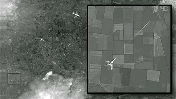
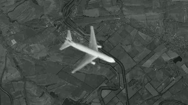
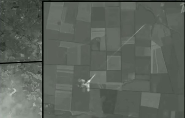
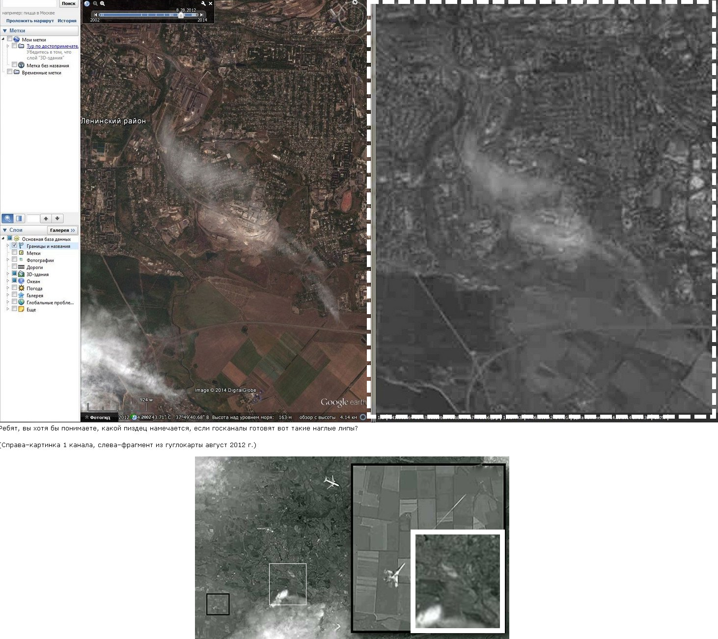
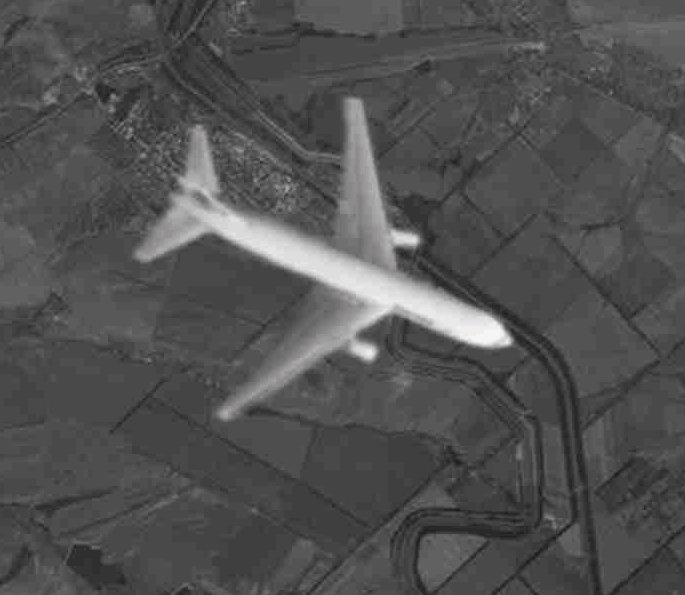
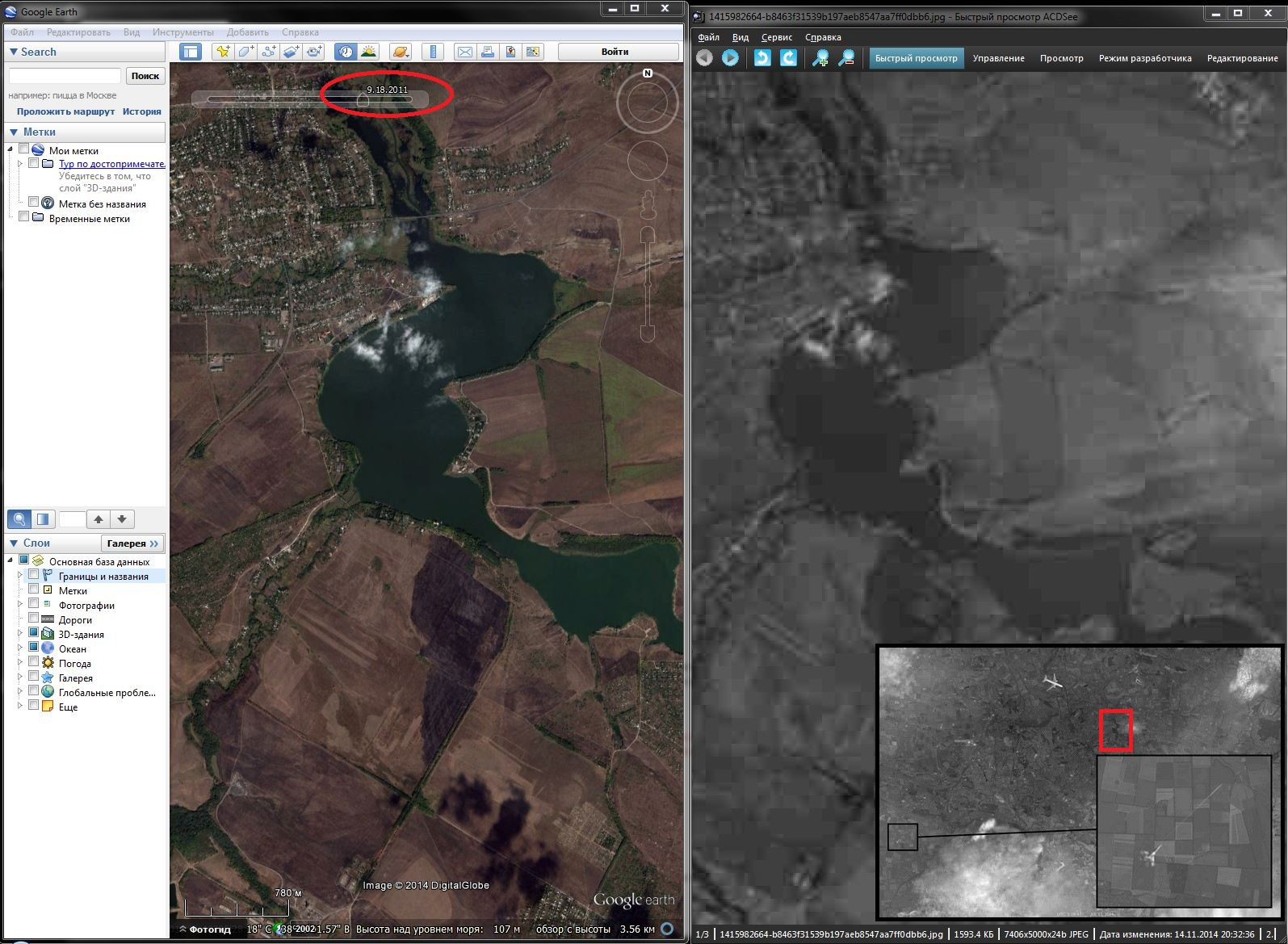
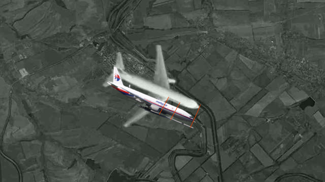
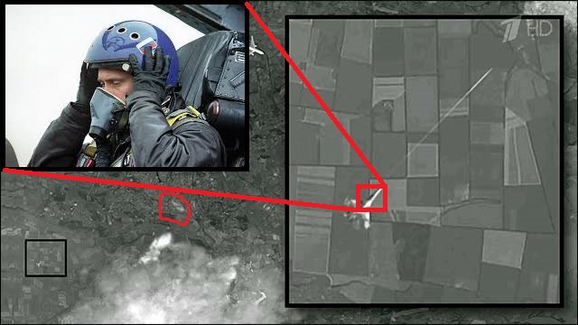
Debunked: this photo shows a Ukraine Mig-29 shot down MH17

Can you post translated sections of the article that describe where they got it?

The article is a transcript of the video. It says that the photos were attached to the following email, signed by a George Bilt:
Screen shot 2014-11-14 at 17.10.31.png

The presenter suggested that these photos possibly were taken by an American or British spy satellite.
 
If they pumped cannon rounds into the cockpit and the cockpit fell off the plane, then why would they need to blow up the engine to cause it to crash?
 
On image is Su-27 and not MIG-29 how its said in article.

Su-27

I'm not sure that can be confidently stated. I think the angle of the tail section more resembles a MIG than the SU
upload_2014-11-15_7-37-0.png
upload_2014-11-15_7-36-18.png
But this is the first time that a MIG and not an SU has been mentioned in connection to the incident.
 
I'm not sure that can be confidently stated. I think the angle of the tail section more resembles a MIG than the SU
upload_2014-11-15_7-37-0.png
upload_2014-11-15_7-36-18.png
But this is the first time that a MIG and not an SU has been mentioned in connection to the incident.

Look at front, Su-27 is more narrow shaped.
 
Hello. I am from Russia and here it is what I found.

Pucture from right is a satellite photo from Russian News. Picture from left is a Google Earth photo for 28.08.2012. The same cloud after some years? NOWAY~

 
debunked by many people. See this blog for many evidences this is a fake by an amateur http://www.whathappenedtoflightmh17.com/proof-the-russian-tv-satellite-photo-of-mh17-is-fake/
Not all those points seem solid (no contrails behind the plane doesn't prove it's not in flight for one) but the map photo showing fields with no change from 2012 (or 2002, it's not clear) is the simplest and most obvious debunk.
I couldn't find the exact same image on google earth, the one closest resembling the pattern in one of the fields was a black and white photo from 2011. I think the yandex map may be an original image then not used by google, not sure how to check their image dates though.
 
The airport image (thin horizontal rectangle) is definitely post-2012 as the runways weren't finished before then
But what's weird on google earth is what looks like a wrecked plane in the parking area, between the images 4/28 and 6/19.
Screen Shot 2014-11-15 at 10.56.48 am.png
.Screen Shot 2014-11-15 at 10.57.04 am.png
 
Last edited:
Anyone else think the "missile trail" is a photoshopped airplane contrail..err..I mean chemtrail :eek:
 
From post #3: Photo of English-language transcript. (Paragraph three):

"...aiming right and sharp at the pilots' abdomen region." Nonsense. Their heads are the most obvious targets, through the windows.

On further reflection, one might wish to 'argue' that the "abdomen region" of the two pilots was guessed at...this type of accuracy is also not believable. In addition, in any case "IF" it is as claimed in that transcript? I.E., "(To silence killing them instantly - not even a scream)". Just wrong. People hit in that manner may well cry out in pain, and thus the CVR would have recorded it. Only way to NOT hear a pilot make a sound is when the main electrical power for the whole airplane is shut off, thus stopping the CVR recording capability.

So agree, this is a hoax.
 
Last edited:
Another feature debunked ('cause this is kind of fun)...
Detail from claimed 'sat image' from July 17th.
Screen Shot 2014-11-15 at 11.49.12 am.png
This feature on July 16th.
Screen Shot 2014-11-15 at 11.49.49 am.png
The last time it looked like the claimed image.Screen Shot 2014-11-15 at 11.48.49 am.png
 

Attachments

  • Screen Shot 2014-11-15 at 11.49.12 am.png
    Screen Shot 2014-11-15 at 11.49.12 am.png
    63.4 KB · Views: 551
Last edited:
Ivan Adrievskiy, vice president of Russian Engineers Union, said: 'We see a photograph taken from space from a low orbit. Usually such images are taken for the sake of general reconnaissance of the air and the ground.

'The coordinates of the photograph mean we can suppose that the image was taken by an American or British satellite.

'We have studied this picture in detail and did not find any sign proving it to be fake
.'
Content from External Source
:p
At least no-one official is endorsing this.
 
Another feature debunked ('cause this is kind of fun)...
Detail from claimed 'sat image' from July 17th.
Screen Shot 2014-11-15 at 11.49.12 am.png
This feature on July 16th.
Screen Shot 2014-11-15 at 11.49.49 am.png
The last time it looked like the claimed image.Screen Shot 2014-11-15 at 11.48.49 am.png
What is that a couple of bridges that were built after 2010?
 
The airport image (thin horizontal rectangle) is definitely post-2012 as the runways weren't finished before then
But what's weird on google earth is what looks like a wrecked plane in the parking area, between the images 4/28 and 6/19.
Screen Shot 2014-11-15 at 10.56.48 am.png
.Screen Shot 2014-11-15 at 10.57.04 am.png
Presumably damage from the battle at the end of May?

http://en.m.wikipedia.org/wiki/First_Battle_of_Donetsk_Airport

That airport (which was only rebuilt a couple of years ago) has since been more or less completely destroyed by fighting.


http://www.dailymail.co.uk/news/art...says-331-killed-month-s-ceasefire-agreed.html
 
Last edited:
Well, maybe not so weird when you take it being an active warzone into account then. :)

Thirty-four of the dead insurgents were Russian nationals and Donetsk insurgents claimed the bodies were returned to Russia.[30] It was later revealed the bodies were returned covertly to hide the fact that they were Russian, eventually ending up in a Rostov-on-Don morgue in the Russian Federation.[31]
Content from External Source
 
Seems to be debunked. A couple of thoughts, the US spends almost a 100 billion dollars on intelligence, isn't it logical that unless they're only spying on the western world, that they would have genuine images of the shootdown? Also how reliable is Google Earth? This image has been out there for a while and the head of Google is very close to the US government, I've heard. Could the images simply be altered at google?
 
Seems to be debunked. A couple of thoughts, the US spends almost a 100 billion dollars on intelligence, isn't it logical that unless they're only spying on the western world, that they would have genuine images of the shootdown? Also how reliable is Google Earth? This image has been out there for a while and the head of Google is very close to the US government, I've heard. Could the images simply be altered at google?
It's not exactly logical that $100 billion on intelligence = they must have footage of the moment of attack.

You'll have to flesh out your thinking a bit more on your second point. Reliable in what way? Why would google alter the images in google earth to include parts of the fake picture, and what does 'being close' to the US government mean exactly and why does it have any bearing on this fake?
The one conspiracy theory in regard to this that might have some merit is that it was an obvious fake put out to discredit the report it supposedly was in support of, but I don't really think it requires any effort like this to do that.
 
Seems to be debunked. A couple of thoughts, the US spends almost a 100 billion dollars on intelligence, isn't it logical that unless they're only spying on the western world, that they would have genuine images of the shootdown? Also how reliable is Google Earth? This image has been out there for a while and the head of Google is very close to the US government, I've heard. Could the images simply be altered at google?
First claim: what are the chances that a spy satellite would just happen to be in exactly the right position at exactly the right moment to take a photo of such an event? Pretty astronomically tiny! However large the US government spying budget is, they don't have a live view of the planet that they can just zoom in on any spot at any time. Spy satellites don't work like that.

As for the claim of altered images at Google. Well there is no evidence that it has been altered. And Google doesn't generate its own satellite imagery, of course. All the satellite images on Google Earth are from commercial image providers, and can be checked with the providers, so if anyone is doing the altering, it wouldn't be Google.

And there are plenty of other reasons it is fake. For one, the size of the plane is ridiculously huge. If you measure the plane on the image, then plug in the altitude of the satellite that took the image and the altitude of the plane, the airliner would have to be about two and a half miles long!
 
Last edited:
It's not exactly logical that $100 billion on intelligence = they must have footage of the moment of attack.

You'll have to flesh out your thinking a bit more on your second point. Reliable in what way? Why would google alter the images in google earth to include parts of the fake picture, and what does 'being close' to the US government mean exactly and why does it have any bearing on this fake?
The one conspiracy theory in regard to this that might have some merit is that it was an obvious fake put out to discredit the report it supposedly was in support of, but I don't really think it requires any effort like this to do that.
By seems to be debunked, was agreeing it was probably fake. I wasn't claiming that google had faked pictures, I was asking whether that possibility shouldn't be considered. After all, Google Earth was a program named Keyhole until the CIA sold it to them and they are partnered with the CIA in Recorded Future.Their head agrees with the government that there should noI didn't come here to argue. privacy for anyone. I don't agree that it is improbable that we were keeping close watch on Ukraine.
 
Back
Top