Earth curvature refraction experiments - debunking flat/concave Earth

That error reminds me of an Apollo hoaxer trying to use absolute speeds rather than velocity changes

I think I know that guy. His calculation was for the fuel needed for Lunar Orbit Insertion. I told him the rocket equation was the proper way to calculate fuel requirements but he said the rocket equation only applied to acceleration and it did not apply to deceleration!
 
A general problem here seems to be doing geometry with words rather than pictures.

As Astrobrant2 has put it, 'math is kryptonite to flat Earthers.' FE fans unanimously confuse curvature "dropoff," with bulge height, as they only cling to the simple "8 inches per mile squared" as the be-all and end-all of bulge calculation. I use this diagram to clearly illustrate their mistake without going into the trig they have no patience for, which has been working wonders for getting thru to them.

 
As Astrobrant2 has put it, 'math is kryptonite to flat Earthers.' FE fans unanimously confuse curvature "dropoff," with bulge height, as they only cling to the simple "8 inches per mile squared" as the be-all and end-all of bulge calculation. I use this diagram to clearly illustrate their mistake without going into the trig they have no patience for, which has been working wonders for getting thru to them.


That's basically like in my interactive version, although maybe I should add the 8 inch thing for clarity:
 
Is it just me or is Flat Earth theories trending within the conspiracy community right now? I keep seeing them being mentioned more and more frequent. According to Google Trends, "Flat Earth" is trending on their search engine.

Yes, there is an explosion of thousands of new flat Earth videos on YT since February. I suspect it started with the news story of the Saudi cleric questioning the spinning Earth in a videotaped lecture, that I think made sense to a lot of people who were inspired to search the subject. http://www.dailymail.co.uk/news/art...nt-sun-rotates-Earth-planes-not-able-fly.html Variations of the question, "why dont we feel Earth rotating?" are by far the most common comments posted on my flat Earth debunk vid, where the number of views have only risen since I happened to upload it on the same day the Saudi cleric story broke.
 
Last edited:
That's basically like in my interactive version,...

Which is wonderful, I forgot to add! I always link to that post at the same time as my illustration.


...although maybe I should add the 8 inch thing for clarity:

I do wish there were a version of it representing maybe 100 miles wide, with values in meters/feet that anyone may use to figure Earth bulge in the most common examples that continually come up in curvature debates. I know the curve wont be as apparent (is a larger version possible?), and I am not sure of the difficulty in setting it up, but I think would be very useful in settling abounding mistaken bulge claims.
 
I do wish there were a version of it representing maybe 100 miles wide, with values in meters/feet that anyone may use to figure Earth bulge in the most common examples that continually come up in curvature debates. I know the curve wont be as apparent (is a larger version possible?), and I am not sure of the difficulty in setting it up, but I think would be very useful in settling abounding mistaken bulge claims.

The curve is barely visible at 100 miles, as the bulge is only 1/3 of a mile.
 
The curve is barely visible at 100 miles, as the bulge is only 1/3 of a mile.

Thanks, but yeah, that wont work. When I started this thread, I searched for a site that would allow a user to enter observer height and target distance, and would then calculate bulge height and target obscuration height, so the user does not have to figure the math that FEers are immune to (I suck at too). A flat Earther just provided a site link that at least calculates the 'target hidden height.' http://dizzib.github.io/earth/curve-calc/index.html But it does not also show bulge height or horizon distance, so he still argued that the bulge and obscuration height should be the same value.
 
Thanks, but yeah, that wont work. When I started this thread, I searched for a site that would allow a user to enter observer height and target distance, and would then calculate bulge height and target obscuration height, so the user does not have to figure the math that FEers are immune to (I suck at too). A flat Earther just provided a site link that at least calculates the 'target hidden height.' http://dizzib.github.io/earth/curve-calc/index.html But it does not also show bulge height or horizon distance, so he still argued that the bulge and obscuration height should be the same value.

Try this:
https://www.metabunk.org/curve/
 
Hi, Mick. You formula is good, but only works for distances where the length "d" is very close to the arc length that defines the ground distance between the objects - which is the actual distance that people will be giving.
Over longer distances, your formula will fall apart - but it is a very good approximation for most calculations done for observers near the surface of the Earth, due to its large scale.

Once you gain significant altitude, however, it doesn't hold water.

I have a blog post here, which goes through all the geometry involved, and gives the precise formulas involved in figuring out the "drop off" of the spheroidal Earth, the amount of an object that will be obscured by the horizon (and thus the minimum height an object must be to lie level with the horizon), and the relative distance below the horizon line of sight a point on the surface of the Earth will be, all with only the variables of the ground distance to the object, the height of the observer and the radius of the Earth:
https://chizzlewit.wordpress.com/2015/05/13/working-with-the-curvaure-of-a-spherical-earth/

The only thing is that the results are all based on the pure geometry of a perfectly spheroidal Earth, without refraction - largely because the Earth is close enough to a perfect sphere (the equatorial bulge is only 1/300th the mean radius of the planet, after all), and because refraction is not an exact thing since it depends on the weather conditions for the day.

Whilst the formulas are more involved, they are complete and will produce precise results for every value of any of the variables.
However, as I say, your approximate formula is good for short distances and observers close to the surface. The problem, though, will come from anyone using that formula to figure out more extreme values.

I encourage you to check out the blog post.
 
Hi, Mick. You formula is good, but only works for distances where the length "d" is very close to the arc length that defines the ground distance between the objects - which is the actual distance that people will be giving.
Over longer distances, your formula will fall apart - but it is a very good approximation for most calculations done for observers near the surface of the Earth, due to its large scale.

Yeah, it's intended for the use cases described in the thread - like sighting across a lake. It has the advantage that the math is relatively straightforward. Unfortunately to illustrate the math in a diagram I have to end up essentially showing a situation where it really does not work.

I'll see if I can shoehorn your equation into my calculator.
 
It can be represented as a relatively short single equatioin,

amount obscured = r/cos( d/r - asin(sqrt(h*(2*r+h)) / (r+h) ) ) - r

Where h = height of the observer, and d = distance between points (as a great circle), and the trig functions use radians

I've updated the calculator.
https://www.metabunk.org/curve/
 
Last edited:
I've been having a conversation concerning this elsewhere, and to be clear there is no question to the fact that the formula you used gives incredibly accurate results for every day observations, is it is intended to do.
As a rule of thumb it is extremely good, given the caveat that it breaks down for more extreme values, which is just a note I would have suggested putting on the calculator, just in case people try to use the formula for more extreme situations.
The formulae I use are unnecessarily unwieldy for those not well versed in geometry, for whom a rule of thumb for every day observations will do, and the difference in accuracy in these cases would be negligible. Other than dealing with more extreme cases, they of interest really to people with more of an understanding of geometry than possibly the average person, or someone learning geometry, because they show the geometric identities of the trigonometric functions (sine, cosine, tangent), and also of some of the more obscure functions that have fallen out of use (much to the chagrin of many geometers), such as the secant, exterior sexcant (exsecant) and the versed sine (versin) functions. It demonstrates that these aren't just obscure functions on a calculator, but that they have actual geometric identities and exist as things that can be drawn and shown to be true.
The exsecant of the angle of the arc length from the horizon to the target height level with the horizon is the exsecant, and the bulge height (or the arc height) between observer and target is the versed sine of the angle of the arc length of the ground distance from observer to the target, for instance. Not much use to your every day person, but illuminating to those interested in geometry.
Beyond that, they are cumbersome, I must readily agree. Their beauty comes from what they demonstrate about geometry, which is something that won't come from a calculator as it is, so one could argue that it is academic (or that I am pedantic ;) ).

It can be represented as a relatively short single equatioin,

amount obscured = r/cos( d/r - asin(sqrt(h*(2*r+h)) / (r+h) ) ) - r

Where h = height of the observer, and d = distance between points (as a great circle), and the trig functions use radians

I've updated the calculator.
https://www.metabunk.org/curve/

Yep, that equation, as you say is absolutely correct. My original equations only use the sine function, to keep things simple.

If you wanted the simplest equation,but involving the more obscure trig function of exsecant, it would be:
r * exsec( (360*d/(2pi*r) ) - ( arccos(r/(r+h) )

The Exsecant function is simple the Secant of the angle minus 1, making this equation expand out to:
r * ( sec( (360*d/(2pi*r) ) - ( arccos(20903520/ (20903520+35) ) ) ) -1 )

Because most calculators don't have things like versin and exsecant on them (BOO!), so you have to use the secant function instead.

(And importantly, the trig functions here use degrees in this equation - I had a heart attack and thought I'd broken trig until I realised I hadn't reset the calculator to degrees, lol.)
However, due to the obscurity of even the secant function to most people, it is best to use the more familiar functions of sine, cosine and tangent.
As I say, I just like showing the relation between the equations, because it gives the functions geometric identities that can be visualised, rather than just being abstract functions on a calculator. All that will fly over the heads of flat Earthers though ;)

As a last point, whilst a link to this thread for further clarification is great, the calculator may benefit from a short description involving the equation and a short write up of what is going on within it - just to help people see the equation and get some kind of visualisation as to what's going on. But it is a great tool - thanks for putting it up ;)
 
Mr. Ziller; we were exchanging comments at your YT channel last week - I go by the handle "zomby woof" over there. You said you would check my math for me if I asked. I am asking. Or at least check my logic, since I don't do any actual math.

I'm going back to this video again, because the kid who posted it has accidently found a striking proof that the Earth is not flat. You don't often get a view like this of an object that is so identifiable. We can see exactly how much of it is hidden. If the Earth were flat, none of it should be hidden.

We can also see that no matter how much the camera is zoomed in, no more or less of the tower is visible. Which disproves some common ideas about perspective FE's have.

And we can also refute atmospheric extinction in this case.

I've added some simple geometry below and want to see if it checks out.


This is a video taken from a bluff or escarpment called The World's Edge, near the town of Edneyville, NC. You can see the top of the tallest tower in Charlotte, NC about 80 miles away.

We have to look at the elevations along the line of sight between The World's Edge and Charlotte. If there were no hills or ridges between The World's Edge and Charlotte, and if the world were flat, we would see all of Charlotte. He is implying that there is a ridge which is blocking the view, and just allowing the Duke Energy Center tower to peek over that elevation.


What is the line of sight between those two points? We can ignore all the closer ridges and hills we can see, because obviously they are not blocking our line of sight. It's that last ridge that we have to look at. The compass heading from The World's Edge to Charlotte is 97 degrees; 7 degrees south of east. The line of sight passes over Gastonia, NC. - (we can see the ridge get higher toward King's Mountain on our right). This is the last high elevation to the west of Charlotte. On the east side of this ridge is a low area around the Catawba River. Charlotte is 20 miles east of the ridge and is slightly higher than the river and its lakes.


That last ridge around Gastonia is 20 miles west of Charlotte and is about 850 feet above sea level. Charlotte is 748 feet above sea level. Which means that ridge is only 102 feet higher than Charlotte. And 682 feet lower than the top of the Duke Energy Center tower.


The World's Edge is 2,880 feet high (It's actually 2,975 feet as far as I tell, but I'll let that slide.)

World's Edge is 80 miles west of Charlotte

The last ridge is 850 feet high and is 20 miles west of Charlotte.


Draw two right triangles. The base of each triangle will be at Charlotte's altitude so we can get a corner of the triangle on Charlotte's street level. Call that corner A. The hypotenuse of each triangle will be the line of sight between Edge of the World or the Gastonia ridge to Charlotte.

Then compare the interior angles of these triangles at corner A. The hypotenuse of the triangle with the greater interior angle at A will be exterior to the hypotenuse of the triangle with the lesser interior angle. In other words, the line of sight will be higher. If the Edge of the World line of sight is higher, it will pass over the Gastonia ridge.


1. World's Edge: Subtract the altitude of Charlotte from the altitude of the World's Edge so that we can establish the base of the triangle at Charlotte's altitude

2,880 - 748 = 2,132 feet
This is the vertical side of the triangle


The base of the triangle is 80 miles

5,280 feet x 80 miles = 422, 400 feet


I cheated and just used this calculator to find the interior angle at A.

http://www.mathportal.org/calculators/plane-geometry-calculators/right-triangle-calculator.php

The interior angle at A is 0.2892 degrees


2. Gastonia ridge: Subtract the altitude of Charlotte from the altitude of the ridge so that we can establish the base of the triangle at Charlotte's altitude


850 - 748 = 102 feet
This is the vertical side


The base of the triangle is 20 miles

5,280 feet x 20 miles = 105,600 feet


Using the same calculator

The interior angle of A is 0.0555 degrees

A smaller angle. This means that the line of sight from Charlotte will pass over the ridge on which Gastonia sits. Easily. Which means if the Earth were flat we shouldn't see the Duke Energy Center Tower just peeking over that ridge. We should see all of Charlotte.


And because we can see the tower, the clarity of the atmosphere is good enough that we would be able to do so. Especially at night. Are the lights of Charlotte visible at night from the World's Edge? Atmospheric extinction can't explain this away.


If someone wants to argue that the last ridge we see is not in fact the ridge on which Gastonia sits, but instead is a much higher ridge that's closer to the camera and is hiding the area around Gastonia... Where is that ridge on the map? If it were closer to the camera it would have to be taller than the ridge on which Gastonia sits to block the line of sight. The closer to the camera it was, the higher it would have to be.


Where on the map is that tall ridge along the line of sight between The World's Edge and Charlotte?


You also have to look at the video and count the towns (water towers) and ridges that we can see. We're seeing a long, long way to that last ridge. The theoretical ridge has to be in between those ridges and towns and the ridge on which Gastonia sits. Where is it?

I've identified several of those towers and I think we can rule out the mystery ridge. We could also check with a local expert, of course.

Thanks
 
Last edited:
Quick question - how do flat-Earth proponents explain trans-Pacific flight?

It's NASA lies, they don't exist. ;)

In all seriousness though I'm right there with you. The existence of Qantas flight QF28 and the fact that thousands of people (who are not NASA employees) have flown it, and it didn't take them 2 days to do it, is conclusive and undeniable proof that the earth is NOT flat as per the thread below.

https://www.metabunk.org/flat-earth...lights-from-australia-to-south-america.t6483/
 
T...

Do I believe the Earth is flat? No. Do I believe it is necessarily a ball? No. As far as I'm concerned, why commit to something I haven't personally verified. No point, really. Could be a ball, could be flat...seen some interesting questions either way.

1. The flat Earth. Nothing debunks the flat Earth model like seeing it in action (duration 3m22s)-


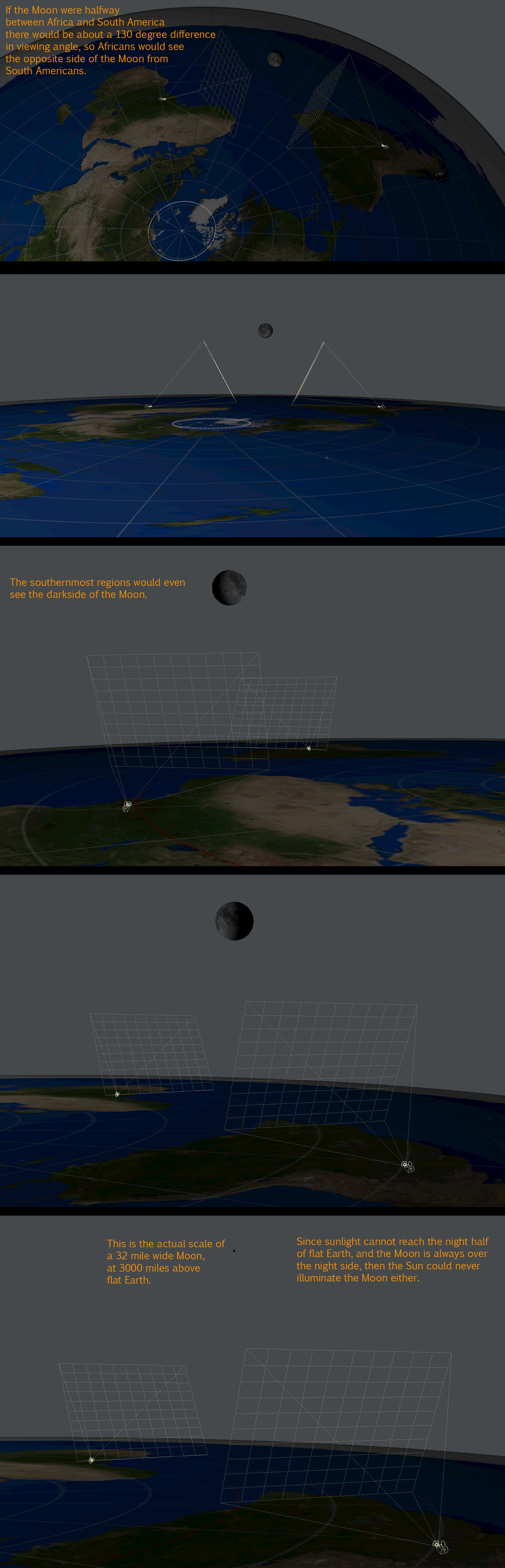
2. The tidal locked Moon. According to flat Earth consensus, the Moon circles 3,000 miles above a flat Earth. In which case we would have to see every side of the Moon each day, and the phases would cycle every 24 hours. Example illustration-
On flat earth, Africans could simultaneously see the opposite side of the Moon from South Americans. And when the Moon is over the same time zone as Quebec, Canadians above the Tropic of Cancer would see the front of a nearly full moon, while Chileans in the same time zone below the Tropic of Capricorn would simultaneously see the dark backside of the Moon. But here in reality, we all only ever see the same side of the Moon, with an insignificant change in orbital viewing angle because it is 238,900 miles away. This point alone is an irrefutable debunk of flat Earth.

3. Star Trails. If Earth is flat, how can billions of people see two different sets of constellations rotating in opposite directions, around two opposite poles? How can people in the southern hemisphere essentially stand in a circle with their backs to each other, and all be facing the same southern constellation? Illustration-


Anyone in the Southern Hemisphere may observe how stars rotate clockwise around the South Celestial Pole, where Polaris, Ursa Minor, Ursa Major, and Cassiopeia are absent - while anyone in the Northern Hemispshere sees stars rotating counter-clockwise around the North Celestial Pole, where Crux, Centaurus, and Carina are absent - On flat Earth, it is geometrically impossible to see these two completely different skies, rotating in opposing directions around two different poles.

Google "star trails" to see thousands of photo and video examples from around the world, and the star rotation direction always corresponds with the polar hemisphere. From the Equator, you can see stars rotating simultaneously around both, opposite poles. Here is a 360 degree panoramic timelapse showing stars simultaneously rotating clockwise and counter-clockwise-

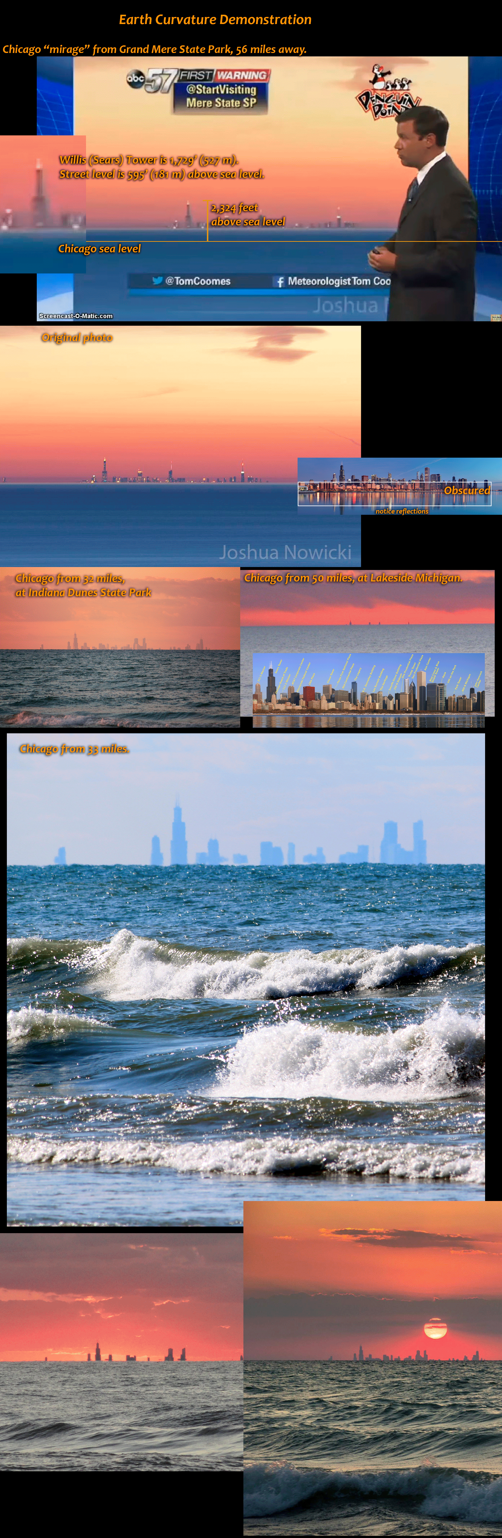
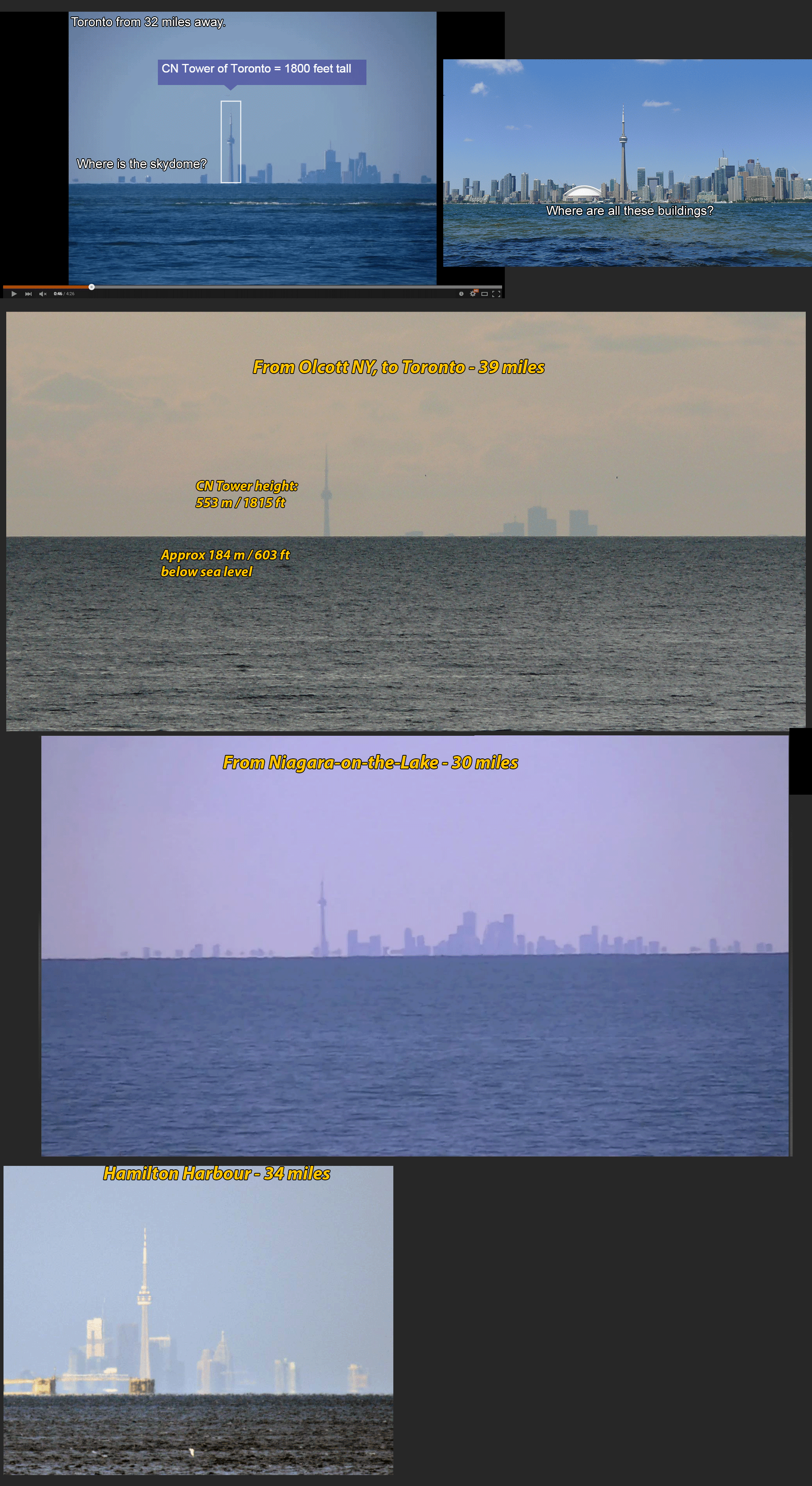
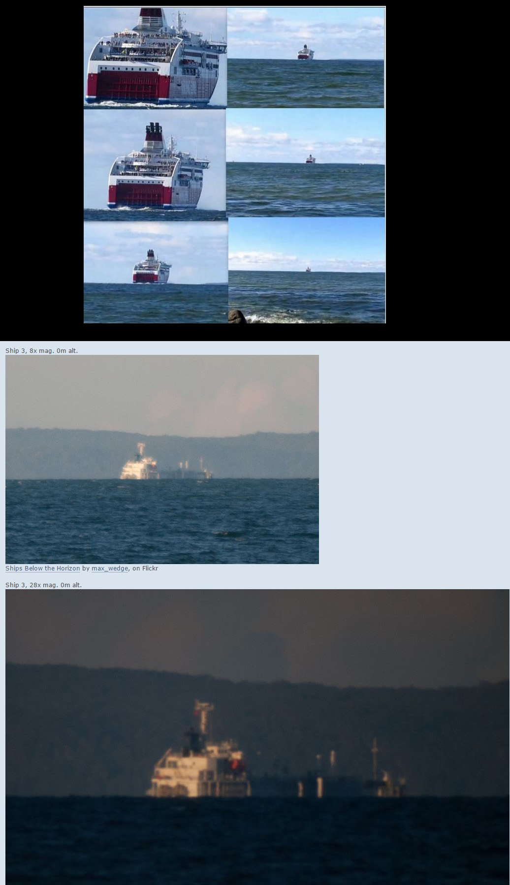
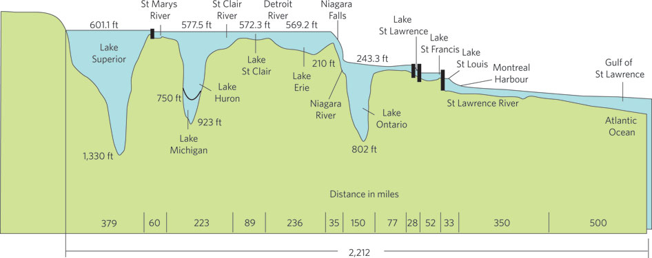
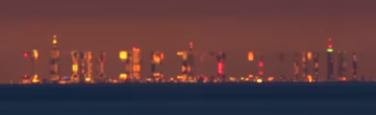
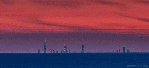
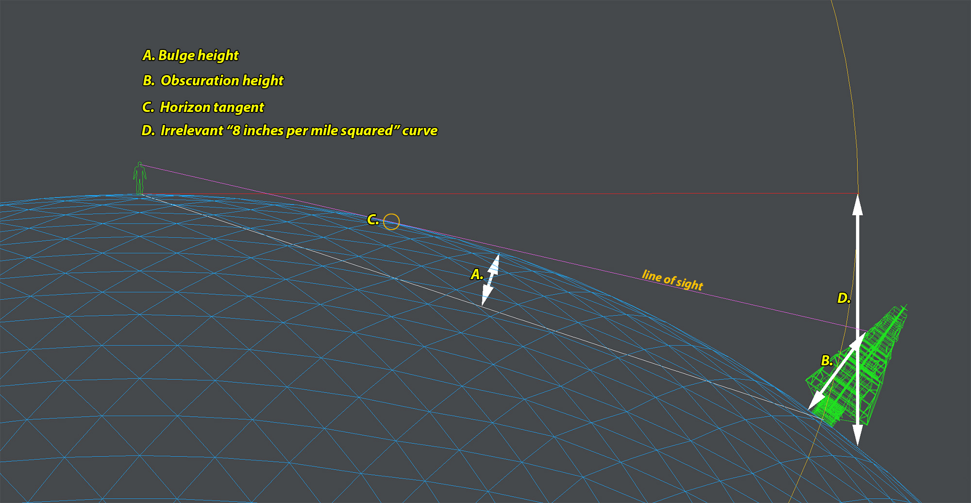
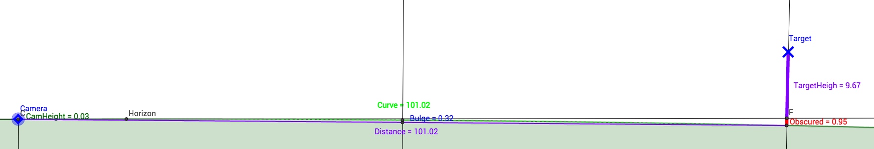
4. Earth bulge. Anyone may observe Earth curvature at sea level depthwise (going away from you) by viewing thru a telephoto/zoom which greatly flattens depth. It is why Toronto appears hundreds of feet below sea level from across Lake Ontario-

Chicago appears hundreds of feet below Lake Michigan-


The CN Tower appears over 600 feet below lake Ontario-


For thousands of years, humans have observed that all ships sailing over horizon always disappear bottom first -

If you think this was cheated by "editing," here is an uncut example-

And _no, "perspective" has nothing to do with objects appearing to sink below sea level. Perspective merely means that objects appear smaller and closer together with distance, and will not cause bottoms of distant objects to appear to flatten into nothing near horizon. "Parallax" is why objects may appear to slide up and down behind the horizon, as a result of changes in viewing angle, which only proves Earth curvature. On a flat Earth, there is no reason for a calm sea level to appear to rise up hundreds of feet between observer and a target. Animated illustration-

And no, increasing magnification will not ccontribute to a parallax shift, because there is no change in physical distance between observer and target. Magnification will only enlarge your view, and will not allow one to magically see behind the horizon. Here are photo examples of ships over horizon where increased magnification does not cause them to appear taller-

5. Sunsets. Billions of people observe the Sun set below horizon daily, like this - If this occurred on flat Earth, the entire world would be cast in darkness at the same second, and there could be no time zones.

6. No accurate flat earth map. If Earth were relatively 2-dimensional geometry, then well-established geographical dimensions should appear proportionately correct on a 2-dimensional map. But they do not at all. The flat Earth map grossly distorts continents, and inexplicably stretches longitude and latitude lines to fit. Russia is known to be 6,000 miles long, and Australia is about 2,500 miles long, but on the flat map, Australia is as large as Russia! How would you account for this discrepancy? Here is a flat Earth map with continental dimensions preserved- https://wharferj.files.wordpress.com/2011/04/dymaxion-map-large1.png It is geometrically impossible to accurately fit Earth geography into a 2D disc shape, because Earth is a sphere. It is like trying to make a deflated basketball lay flat with all of the skin facing up.


7. Flight durations. Already discussed. Even a former flat Earth advocate admitted Earth cant be flat due to polar flights from Johannesburg to Sydney travel time of 12 hours- and he commendably deleted all his flat Earth vids.

The same flight distance on flat Earth would take FIVE times longer- https://www.youtube.com/watch?v=myBcAUAtF34


8. The ice wall of doom! Anyone may book a flight to or over Antarctica, just as tens of thousands of people do annually.

A380 takes the polar route to Sydney. http://videos.airbus.com/video/iLyROoafIlXu.html *"The crew takes in spectacular views of Antarctica"*

Antarctica tourism and South Pole flights - http://www.adventure-network.com/

Antarctica flights- https://www.youtube.com/watch?v=UZVFan7jL80&feature=youtu.be

Tours in The Antarctic http://www.lonelyplanet.com/antarctica/tours
"over 45 thousand people visited Antarctica during the recent Argentine summer: it's a seven times growth in the last 16 years. " (2009)

Discover Antarctica http://www.hurtigruten.com/us/explorer-voyages/antarctica/

Antarctica Voyages- http://www.hollandamerica.com/cruise-destinations/grand-south-voyages-cruise
"A complete circumnavigation, from Incan empires to Brazilian beaches, icy Antarctica to the steamy Amazon — all roundtrip from Ft. Lauderdale aboard ms Prinsendam."

Best Antarctica Cruises http://www.cruisecritic.com/articles.cfm?ID=1327

*Tourism in Antarctica* - http://en.wikipedia.org/wiki/Tourism_in_Antarctica

Antarctica flights- http://www.antarcticaflights.com.au/

First skiers in Antarctica- http://www.explorersweb.com/polar/news.php?url=south-pole-update_1415554800

U.S. Department of State- Open Skies Treaty- http://www.state.gov/t/avc/trty/102337.htm
"...is one of the most wide-ranging international efforts to date promoting openness and transparency of military forces and activities. "

Antarctic Treaty System http://en.wikipedia.org/wiki/Antarctic_Treaty_System "establishes freedom of scientific investigation and bans military activity on that continent. " "in the interests of all mankind that Antarctica shall continue forever to be used exclusively for peaceful purposes and shall not become the scene or object of international discord."

http://www.usap.gov/jobsAndOpportunities/ the USAP deploys roughly 3,000 people to Antarctica every year to conduct scientific research, or provide support to researchers through the operation and maintenance of the research stations and vessels.

Jobs in Antarctica- http://www.coolantarctica.com/Community/find_a_job_in_antarctica.php

9. Space travel. All space travel must be fake. Debunked in my video (linked to start at 7:41)- https://youtu.be/_YzeGRFDIms?t=461 The interior Skylab footage at 9:32 is irrefutable evidence of astronauts weightless in space. Wires could not possibly accommodate their intertwining motion without becoming tangled, the shot is too long to take place in a diving plane where reduced gravity only lasts 25 seconds, and this was the cutting edge of photoreal computer animation in 1972- https://vimeo.com/16292363 Therefore astronauts have traveled into space.

10 illustrated disproofs of flat Earth by Astrobrant2. http://s813.photobucket.com/user/astrobrant2/library/Disproofs of Flat Earth?sort=6&page=1

11. List of historic circumnavigations. https://en.m.wikipedia.org/wiki/List_of_circumnavigations

12. More meteors seen after midnight because your local part of the Earth is facing the direction of its orbital motion around the Sun http://www.astronomynotes.com/solfluf/s3.htm

13. Implausibly mammoth conspiracy requiring involvement of over 50 space agencies around the world, and every news agency, all telecommunications companies, and shipping companies, and universities, and millions of dedicated professional physicists, engineers, meteorologists, pilots, navigators, oceanographers, cartographers, are all lying, bribed or threatened into participating in a global super conspiracy of the last century, along with their families, without any clear motive, and without a single leak or whistle blower, not one single, deathbed confession or drunken admission ever.

14. Coriolis Effect. There would have to be an awful lot of confused experts.

FIELD ARTILLERY, VOL 6, BALLISTICS AND AMMUNITION http://www.uscrow.org/downloads/Ammunition-Guides/Ballistics-and-Ammunition.pdf"The next important factor in drift is *Coriolis acceleration.* ... It would be present if the projectile were fired in a vacuum. It does, however, depend on the latitude and gearing of the gun and on its range. Its effect is opposite north and south of the equator. For long range guns it is sometimes almost as great as the gyroscopic effect."

Marine Corps Manual- Field Artillery Manual Cannon Gunnery- "Deviations From Standard Conditions. - *Rotation of the earth."* http://fas.org/man/dod-101/sys/land/docs/fm6-40-ch3.htm

*Modern Exterior Ballistics* (McCoy, Robert [1999]) _a comprehensive text covering the basic free flight dynamics of symmetric projectiles._

Coriolis effect of a 7.62mm Ball M80 Bullet.
500 yards - .6 inches
1000 yards - 2.8 in
1500 yards - 7.6 in
2000 yards - 15.9 in

"The basic principles of ballistic science are developed from a comprehensive definition of the aerodynamic forces that control the flight dynamics of symmetric projectiles. The author carefully starts with the basic vacuum point mass trajectory, adds the effects of drag, discusses the action of winds, simple flat fire approximations, *Coriolis effects* and concludes with the classic modified point mass trajectories."
http://riflemansjournal.blogspot.com/2011/03/book-review-modern-exterior-ballistics.html

The Paris Gun - "The distance was so far that the Coriolis effect — the *rotation of the Earth* — was substantial enough to affect trajectory calculations." https://en.wikipedia.org/wiki/Paris_Gun

INS for Guided Missile Systems - http://techdigest.jhuapl.edu/TD/td2804/Bezick.pdf Pg 2 "Moreover,the desired navigation solution typically is formed relative to a second, *rotating Earth-centered* Earth-fixed (ECEF) coordinate frame, (ie, je, ke), having angular velocity ie, relative to the inertial frame. If the position vector of the missile, r, over the Earth’s surface is desired (latitude, longitude, and altitude), then a model for the ellipsoidal shape of the Earth’s surface must be used.

Nat Geo Encyclopedia on Coriolis- "Military aircraft and missile-control technology must calculate the *Coriolis effect* for similar reasons. The target of an air raid could be missed entirely, and innocent people and civilian structures could be damaged. " http://education.nationalgeographic.com/education/encyclopedia/coriolis-effect/?ar_a=1

From Principles of Guided Missiles and Nuclear Weapons - "The CORIOLIS FORCE must also be compensated for. It is *caused by the earth's rotation,* and tends to deflect a missile to the right in the northern hemisphere, and to the left in the southern hemisphere." http://archive.hnsa.org/doc/missile/index.htm "The amount of deviation produced by the *coriolis force* depends on the latitude, length, and direction of the missile flight. "

Arms Guide, "Coriolis effect affects everything not firmly attached to the Earth’s surface." , "the vertical component of the trajectory is called Eötvös Effect. " - http://thearmsguide.com/5329/external-ballistics-the-coriolis-effect-6-theory-section/

Long Range Shooters "Coriolis makes the projectile appear to curve" - http://longrangeshooter.com/2008/05/coriolis-effect/

Applied Ballistics, "There are horizontal and vertical components to Coriolis acceleration." - http://www.appliedballisticsllc.com/spindrift.html

Ballistics calculators that incorporate coriolis must be wrong? - at JBM, http://www.jbmballistics.com/ballistics/calculators/calculators.shtml

Gunwerks, lang range ballistics manufacturer and instruction (in my video)- http://www.gunwerks.com/Long-Range-University/Videos/Long-Range-Ballistics-Videos

An airplane's Inertial Navigation Systems (INS) "must continually correct for a plane's tendency to drift off course because of _Earth's rotational acceleration,_ a consequence of the so-called _Coriolis force."_ From *Inertial Navigation And Flight* - http://science.jrank.org/pages/3581/Inertial-Guidance-Inertial-navigation-flight.html

From Newton's Laws Applied to Navigation - "A firm understanding of four concepts is required to obtain (velocity) from Newton's Laws: gravity, attitude, Earth-referenced velocity and the _Coriolis theorem."_ https://books.google.com/books?id=4...tial navigation system earth coriolis&f=false

And from Institude of Flight System Dynamics - "In a sequential process of levelling and gyro compassing the initial orientation could be derived, when the Earth’s rate of _rotation_ can be sufficiently resolved..." http://www.fsd.mw.tum.de/research/sensors-data-fusion-and-navigation/inertial-navigation/

----------------------------------------------------------------
METEOROLOGY and CORIOLIS:

Wind patterns have _everything_ to do with coriolis effect, illustrated here- https://youtu.be/RT6WwNmDfEQ?t=396 Flat Earth theory has no explanation for trade winds, westerlies and easterlies- http://www.weatherwizkids.com/globalcirculation.gif

http://www.weatheronline.co.uk/reports/wxfacts/Coriolis-effect.htm
" In meteorology, the horizontal component of the Coriolis force is of primary importance, "

American Meteorological Society- "The Coriolis force is defined as always acting perpendicular to the direction of motion; to the right in the Northern Hemisphere to explain rightward turning, and to the left in the Southern Hemisphere to describe leftward turning. It is all necessary *because Earth turns!"*

Hong Kong Observatory- "The apparent deflection of a moving air mass caused by the Earth's rotation is called the Coriolis effect." http://www.hko.gov.hk/education/edu01met/wxphe/ele_geostrophicwind_e.htm

Meteorology. By Professor of Atmospheric and Oceanic Sciences University of Wisconsin-Madison -
"... in the midlatitudes, the Coriolis force is strong; thishas important implications for how we understand midlatitude weather." https://books.google.com/books?id=q...CDgK#v=onepage&q=meteorology coriolis&f=false

Univ of Illinois- "As air moves from high to low pressure in the northern hemisphere, it is deflected to the right by the Coriolis force. " http://ww2010.atmos.uiuc.edu/(Gh)/guides/mtr/fw/crls.rxml

----------------------------------------------------------------
OCEANOGRAPHY and CORIOLIS:
https://en.wikipedia.org/wiki/Physical_oceanography#Coriolis_effect

"Each successive layer of water underneath is effected further by the Coriolis effect (but the foward movement of water is less) creating an Ekman spiral" http://science.kennesaw.edu/~jdirnber/oceanography/LecuturesOceanogr/LecCurrents/LecCurrents.html
"Winds drive surface currents in the ocean, and these currents are effected by the Coriolis effect. "

A Laboratory Demonstration of Coriolis Effects on Wind-Driven ocean currents- http://www.tos.org/oceanography/archive/21-2_beesley.pdf

Oceanography: An Invitation to Marine Science - https://books.google.com/books?id=B...nepage&q=coriolis effect oceanography&f=false

geostrophic ("Earth turning") currents.
http://www.britannica.com/science/ocean-current/Geostrophic-currents "On a nonrotating Earth, water would be accelerated by a horizontal pressure gradient and would flow from high to low pressure. On the rotating Earth, however, the Coriolis force deflects the motion,"

Ocean in Motion: Geostrophic Flow Background-
"A balance develops between the Coriolis force and the force arising from the horizontal water pressure gradient such that surface currents flow parallel to the contours of elevation of sea level. This current is known as geostrophic flow."
http://oceanmotion.org/html/background/geostrophic-flow.htm

Coriolis and Ekman Transport, Penn State Dept of Geosciences, https://www.e-education.psu.edu/earth540/content/c4_p3.html

TX A & M Univ- Geostrophic Equations- http://oceanworld.tamu.edu/resources/ocng_textbook/chapter10/chapter10_02.htm
Cornell Univ- http://www.geo.cornell.edu/ocean/p_ocean/ppt_notes/15_GeostrophicCurrents.pdf "The force balance is between the centripetal force and Coriolis force"
Early Astronomer Described Coriolis Effect Centuries Before Coriolis
http://www.technologyreview.com/vie...ed-coriolis-effect-centuries-before-coriolis/

-----------------------------------------------------------------
CORIOLIS EFFECT ON SATELLITES:
Explaining the Coriolis Effect on the Tethered Satellite
http://www.nasa.gov/audience/foredu...istbytype/Explaining_the_Coriolis_Effect.html

Orbital mechanics- http://physics.info/orbital-mechanics-1/

"Objects orbiting around L4 and L5 are stable because the Coriolis force keeps them spinning around the Lagrange point."
 
My ex-wife used to work in Antarctica, and one of her jobs was to transport supplies from McMurdo to other outposts on the continent. The fact that it didn't take her months to get there seems to indicate to me that that map isn't all that accurate.
 
So how far is it to the horizon if hl in the above diagram = 0?

As you are then drawing the tangent to a circle it is indeed, as Mick said, also 0.
 
Sorry Mick, It was a point from a post much earlier in this thread from Trailspotter which for some reason I thought was the latest comment. Fingers, browser or tiredness . :(
 
@david Ridlen, here is yet another topic you can add to your long list on the Coriolis effect: Celestial Navigation

The Coriolis effect had to be corrected for when using a bubble sextant in a fast moving aircraft in the days of old. A bubble sextant was a sextant with a bubble level installed or attached so the navigator could take sights of celestial bodies if he could not see the horizon. The Air Almanac included a table for correcting for the Coriolis effect: https://docs.google.com/viewer?a=v&...nxmcmVkaWVub29uYW58Z3g6NzgxZjk1NGUxZTI1ODRiOQ
 
Chicago appears hundreds of feet below Lake Michigan-

In the top image, you note that Chicago is 595' above sea level. While this is true, it's irrelevant here, as Lake Michigan at Chicago is 577 feet above sea level.


The street level around Willis Tower is, as you say 595 feet. But that only adds 18 feet to the height of the tower relative to the opposite shoreline, so 18+1729 = 1747 feet.
 
Joshua Nowicki has several photo of Chicago from across the lake, this time lapse video shows the effects of refraction. This is from the dunes at Sawyer, 52 miles away.


Last edited:
On August 4 and 5, I see Mick West and Mark Ziller posted equations for computing the obscured height of an object. A simpler equation using only the Pythagorean formula can be derived and this may be easier for a flatlander to understand.

We are asked to determine the height (above the earth's surface) of the lowest visible point on an object being viewed, given a specified line-of-sight viewing distance , the height of the observer's eye above the earth's surface, and a known value for the earth's radius.

To begin, we know that the Line Of Sight is tangent to the earth's surface at its point of contact with the earth (let's call it the obscuration point) and is by definition, perpendicular to a radial line from the earth's center to the tangent line's point of contact (obscuration point). Given this, we can construct a diagram with two right triangles, where;
1) The earth's radius (the line from the earth's center to the obscuration point) is common to both right triangles.
2) A radial line from earth center to the viewer's height is the hypotenuse of of the 1st triangle.
3) A radial line from earth center to the lowest visible height of the viewed object is the hypotenuse of the 2nd triangle

We need to first calculate the length of the third side of both triangles.

The first triangle consists of a radial line from earth center to the viewer's height (V), the earth's radius out to the obscuration point (R), and the line of sight distance from the viewer to the obscuration point (L1). We can calculate the line of sight distance using the Pythagorean theorem. L1 = (V1^2 - R^2)^.5

The second triangle consists of a radial line from earth center to the lowest visible point of the viewed object (H), the earth radius out to the obscuration point (R), and the line of sight distance from the obscuration point to the lowest visible point of the viewed object (L2). Given that the total viewing distance (L) is specified and we've just calculated L1, determining the length of L2 is trivial. L2 = L - L1. As with the first triangle, we now know two sides of a right triangle and can use the Pythagorean theorem to calculate the third. H = (R^2 + L2^2)^.5

Some minor details in using this approach.
1) Since we want an answer in feet, convert all distances into feet. (e.g. 4000 mile earth radius = 21120000 feet)
2) Add 21120000 to the specified viewer's height (e.g. for 100 foot view height, V = 21120000 + 100)
2) Subtract 2112000 from 'H' in order to get the net height above earth's surface.
 
Thank you for the info. I found Metabunk a couple days ago, as it was referenced in the comments of a 'Flat Earth' video. I wonder if you've yet encountered and possibly even addressed two of the more bizarre claims. 1) Telescopes cannot be trusted because they're made with curved mirrors or curved glass, and their curvature gives the illusion of planets being spherical. 2) If the earth is a spinning globe, the year-round positions of the sun each day at noon (The Analemma: https://en.wikipedia.org/wiki/Analemma) would form a straight line. With respect to #2, is anyone aware of a mathematical model which yields the sun's azimuth and declination as a function of latitude, date, and time?
 
Thank you for the info. I found Metabunk a couple days ago, as it was referenced in the comments of a 'Flat Earth' video. I wonder if you've yet encountered and possibly even addressed two of the more bizarre claims. 1) Telescopes cannot be trusted because they're made with curved mirrors or curved glass, and their curvature gives the illusion of planets being spherical. 2) If the earth is a spinning globe, the year-round positions of the sun each day at noon (The Analemma: https://en.wikipedia.org/wiki/Analemma) would form a straight line.

I have not heard of those. But the first seems to be in the "not even wrong" category, and the second is just a geometry failure.

I try to stay away from Flat Earth debunking, as the people who repeat the theories are generally either trolling or hopeless. For more details on my thoughts on this, see:

https://www.metabunk.org/what-to-do-about-the-flat-earthers-debunk-or-ignore.t6707/
 
You can test point 1 with a magnifying lens or even a pair of glasses. Do they make flat objects appear spherical? No? Ok then. You do get some distortion with lenses, but it's in the image as a whole, not separately on individual objects within it - in an extreme case like a really bad dollar store magnifying glass, several flat objects will look like they're stretched out over the surface of a single large sphere, but they will not each appear to be a sphere themselves or stretched over the surface of different spheres (as you see in pictures of planets alongside their moons).

Additionally, astronomical instruments are created to much finer tolerances than a pair of glasses specifically to control lens distortion.

You can also test it by looking at pictures of nonspherical objects in space - nebulae, galaxies, planetary rings, etc. Space is just full of all kinds of weird shapes that don't even remotely resemble any kind of conic section that could even hypothetically be the result of lens distortion.
 
I have not heard of those. But the first seems to be in the "not even wrong" category, and the second is just a geometry failure.

I try to stay away from Flat Earth debunking, as the people who repeat the theories are generally either trolling or hopeless. For more details on my thoughts on this, see:

https://www.metabunk.org/what-to-do-about-the-flat-earthers-debunk-or-ignore.t6707/

I might be optimistic that I persuaded one or two people to at least consider an alternative to a flat world, and one where there is a worldwide conspiracy to hide it. But having only recently stumbled into the flat earth morass, I'm quickly learning that what you said pretty well sums it up - It is a waste of time.
 
I might be optimistic that I persuaded one or two people to at least consider an alternative to a flat world, and one where there is a worldwide conspiracy to hide it. But having only recently stumbled into the flat earth morass, I'm quickly learning that what you said pretty well sums it up - It is a waste of time.

I think it's a good learning experience to do the calculations. A "real world" geometry exercise for youngsters. But unfortunately it seems many of the actual FE proponents seem a bit stuck there, unable to proceed beyond simple math like the Earth "dropping" so many inches every mile. And then you can't tell if they are deliberately misunderstanding.
 
Just playing around with Google Earth and got a better full view image of Chicago to make the comparison with the entire skyline:


And attached is a KMZ file with various viewpoints
 

Attachments

  • Flat Earth - Chicago Photos.kmz
    3.3 KB · Views: 887
Just playing around with Google Earth and got a better full view image of Chicago to make the comparison with the entire skyline:


And attached is a KMZ file with various viewpoints
Using your KMZ file, I measured the distance between the two marked points (Chicago & Grand Mere) at 56 miles. Are these the correct points for your photograph? If they are and I make a guess that the obstructed height is 400 feet, the 'Curve' calculator estimates the viewer's height at 662 feet. In order to compare measured versus computed values, do you have measured values for both heights?
 
I think your obscured height is about a hundred feet short based on the proportion of the Hancock Tower (far right, 1,128') obscured.

That said, Mick's calculator doesn't take refraction into account, which would obscure less than expected.

The picture is consistent with a Gran Mere Inn location; it's very similar to the view we get from just south of Warren Dunes.
Thanks for the estimate. Since the 'Curve' calculator is symmetrical (either the viewer or viewed height can be entered to find the other value), I entered 56 miles and 500 feet. Ignoring refraction, the viewer then is at 546 feet. If we only knew the height at which the photo was taken, we could then discover how much difference refraction makes across such a distance.
 
Thanks for the estimate. Since the 'Curve' calculator is symmetrical (either the viewer or viewed height can be entered to find the other value), I entered 56 miles and 500 feet. Ignoring refraction, the viewer then is at 546 feet. If we only knew the height at which the photo was taken, we could then discover how much difference refraction makes across such a distance.

In the KMZ the "Height Match" is from a viewpoint where the result visually matches the photo. That's at an eye alt of 695 feet, the lake surface is about 580 feet. So 115 feet above the lake level. This gives a "hidden amount of 1225 feet.

The dunes at Grand Mere go up to 740 feet, so there are plenty of locations that can give this view with zero atmospheric distortion.

Edit: Although I see, 1225 feet is too high .... hmm
 
Last edited:
It's not symmetrical, if you put in 1 foot, then you have 2000 feet hidden at 56 miles.

In the KMZ the "Height Match" is from a viewpoint where the result visually matches the photo. That's at an eye alt of 695 feet, the lake surface is about 580 feet. So 115 feet above the lake level. This gives a "hidden amount of 1225 feet.

The dunes at Grand Mere go up to 740 feet, so there are plenty of locations that can give this vie with zero atmospheric distortion.
I must not have chosen the correct word to describe what I meant by symmetrical. What I meant by symmetrical is that I am not limited to only entering the viewer's height and distance in order to calculate the obstructed height. But by 'symmetrical' I mean that I can enter the obstructed height instead of viewer height and have it calculate the corresponding viewer height. What's a better word for describing this...'Inversability'?
 
Back
Top