Earth curvature refraction experiments - debunking flat/concave Earth

When it comes to refraction I found this interesting video. I think this mountain is the furthest object I found that can be seen.

9cc10b50015cb98cfbdb58374f8b9822.jpg
It is being discussed here right now:
https://www.metabunk.org/observatio...re-of-the-earth-atmospheric-refraction.t8688/
 
9cc10b50015cb98cfbdb58374f8b9822.jpg


Here is the data on it.

Mt. Height - 2784m
Mt distance - 263km
Observer location - Notre Dame du Château
Observer height - 310m
Neatly matches the curvature calculator with a little bit more refraction though (1.22 in stead of 1.16, nothing unusual)
 
If they think this is evidence, then why don't they do 100 miles, at 3 feet elevation?

Arguing with flat earthers (or concave earthers) is generally a waste of time. Many of them are essentially just trolling - arguing a case as a funny intellectual exercise. Then there are some who take it more seriously who use the work of the first group, but often don't really understand it.

But back to this, it seems like a variation of the eponymous "Bishop Experiment"
http://wiki.tfes.org/Experimental_Evidence
External Quote:

California Monterey Bay is a relatively long bay that sits next to the Pacific Ocean. The exact distance between the extremes of the Monterey Bay, Lovers Point in Pacific Grove and Lighthouse State Beach in Santa Cruz, is 33.4 statute miles. See this map.

On a very clear and chilly day it is possible to see Lighthouse Beach from Lovers Point and vice versa. With a good telescope, laying down on the stomach at the edge of the shore on the Lovers Point beach 20 inches above the sea level it is possible to see people at the waters edge on the adjacent beach 33 miles away near the lighthouse. The entire beach is visible down to the water splashing upon the shore. Upon looking into the telescope I can see children running in and out of the water, splashing and playing. I can see people sun bathing at the shore and teenagers merrily throwing Frisbees to one another. I can see runners jogging along the water's edge with their dogs. From my vantage point the entire beach is visible.

IF the earth is a globe, and is 24,900 English statute miles in circumference, the surface of all standing water must have a certain degree of convexity--every part must be an arc of a circle. From the summit of any such arc there will exist a curvature or declination of 8 inches in the first statute mile. In the second mile the fall will be 32 inches; in the third mile, 72 inches, or 6 feet, as shown in this chart. Ergo; looking at the opposite beach 30 miles away there should be a bulge of water over 600 feet tall blocking my view. There isn't.
Actual images of people playing on a beach would be much more significant evidence than some flashes of light. So why not simply take a photo of someone standing on the Antioch Pier, from the Benicia viewpoint?

And given that there are literally millions of combinations of locations in which you could do this simple experiment with a telescope, and millions of people who own telescopes, then why is the internet not flooded with millions of examples of this evidence?

If I still lived near the sea, I'd pop down an try to take photos of the beach at Point Dume (20 miles from Venice).

I was looking into this so-called "Bishop experiment". It seems pretty clear that he was looking in the wrong direction.

This post on the FE Society forum sums it up (although the references to "west" should read "east")

External Quote:
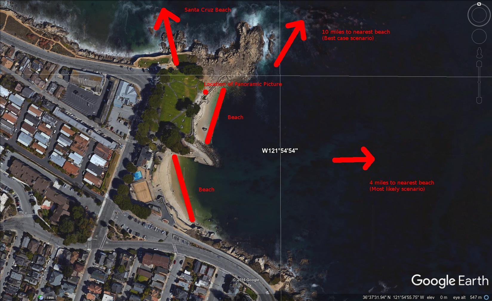
1. The beach Tom claims to be able to see is 23 miles to the North.
2. The beach he provided a picture of is 4 miles to the West. [NB west should read east here, and in 3 and 4]
3. The beach 4 miles to the West is the only beach visible from his specified location, due to a rock outcropping obstructing the view.
4. Even if you circumvent the rock outcropping, the beach 4 miles to the West is the only beach visible in all the user-uploaded panoramas of that location. Remember, Tom claimed he could see the beach with the naked eye.
5. It is doubtful that a telescope can provide the details that Tom claims to see over a distance of 23 miles. Tom avoids providing any details of the telescope he uses.
https://forum.tfes.org/index.php?topic=5431.20

18dc2f7bb5c25287b91f92f408c6a607.png


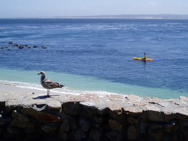
This is the beach that Tom Bishop refers to seeing with the naked eye, and being able to see people splashing in the water through a telescope:

8bdff17dd51394307a6044025e05d6ec.jpg


Clearly this photo is taken looking eastwards towards the prominent dunes at Sand City about 4 miles away:

upload_2017-5-31_10-44-7.png


upload_2017-5-31_10-48-53.png


This piece of "evidence" still seems to be circulating, but it doesn't pass the most basic fact checking.
 
Last edited:
"Drop is the amount the curve of the earth drops away from level, it can be calculated in various ways
which are all about the same for under 100 miles distance
Drop as r-sqrt(r^2-d^2); drop = 784.85 meters (perpendicular to level line)
Drop calculated as 8 inches per mile squared = 8 * d*d / 12; = 6.67 km (6666.67 m)
Drop calculated with trig = r/cos(d/r) - r; = 784.89 meters (perpendicular to target surface)"I've

Something went a bit wrong here for d=100 km., metric units.
Also it would be good if the dip calculation included refraction.

ps. I would be tempted to make the planet, and it radius a constant, to make it more foolproof. I've been caught out!

The "8 inches per mile squared" equation was being used without converting to metric. The metric versions is the somewhat less handy "0.07845590756046217 meters per kilometer squared". I've fixed that. I suppose you could use a different approximations of "about 78mm per km squared" or even in a pinch "about 8cm per km squared"
 
The "8 inches per mile squared" equation was being used without converting to metric. The metric versions is the somewhat less handy "0.07845590756046217 meters per kilometer squared". I've fixed that. I suppose you could use a different approximations of "about 78mm per km squared" or even in a pinch "about 8cm per km squared"
Thanks. One would not want metric FEers getting the wrong answer.
 
Also it would be good if the dip calculation included refraction.

Done:
External Quote:

Distance = 100 km (100000 m), View Height = 120 meters Radius = 6371 km (6371000 m)

Results ignoring refraction
Horizon = 39.1 km (39103.13 m)
Bulge = 196.2 meters
Drop = 784.85 meters
Hidden= 291.03 meters
Horizon Dip = 0.352 Degrees, (0.0061 Radians)


With Standard Refraction 7/6*r, radius = 7432.83 km (7432833.33 m)
Refracted Horizon = 42.24 km (42236.17 m)
Refracted Drop= 672.72 meters
Refracted Hidden= 224.45 meters
Refracted Dip = 0.326 Degrees, (0.0057 Radians)

I don't have a "refracted bulge", as I'm not sure it really makes sense. Maybe I should just move "Bulge" into the advanced section?
 
Mick West, I find the curve calculator very useful when arguing with flat earthers, thank you.:)
If I may ask for improvements, it would be to
* Use consistent terms. x/Hidden/Obscured seems to mean the same thing
* Augment the diagram at the bottom so that in includes lines showing what is meant by "drop"
This. I was just going to say the same.
The 'a', 'b', 'd', 'x' never come back in the summary at the top.
The user has to guess what 'obscured' is.
if 'hidden' is obscured, then what is 'drop'.
These things are not clear.

Also, display the math used. Don't just show the answer, show how you got to that answer. (EDIT: ah, 'advanced' shows them, title is not clear)

Also, and I know I am pushing it now, perhaps, it would be super cool if you could show the answer... in the diagram. Some people are really visual. They barely read numbers. Showing the actual angles and sizes could help. A lot. For visually understanding what is going on. 'Just' draw the answer out, zoom in on the relevant part. Scale misconceptions are one of the things that keep flat earth going. (Keep the old diagram too, for when the data makes a very very thin triangle, people can still see which parameters are where.) To make things more visible when needed you could have some 'stretch/shrink horizontal/vertical 10times' buttons. Add current magnification on the axis in the diagram. It is worth the effort. Many people use this calculator, and the impact would be much larger if the answers where given in a visual observable way.

Make the length of the curved line between observer and object known.

Allow for other combinations of data input: for example, if 2m is obscured, with eyes at 1.4 meter, give all the other numbers. Or: Of the bulge is 20cm, and eyes are at 3m, give all the other numbers. Etc.
Only doing 'distance' and 'eye' as input is a bit very restrictive.

Distance is almost never the thing you actually have available to put in: people put in the curved line between the two points as 'distance' mostly now I guess. If I walk 2 km besides a canal, I am not walking distance (d) I am walking the curved line...

Make distance between top of both objects known. This way people can check things like bridges and fences being longer at the top then at the bottom.

One thing that really bugs me at the moment is tiny distances. The granularity of the numbers is just a bit too large, IMHO. Take for instance (metric) distance 1.6km, eye height 0.1m, obscured: 0.02 meter (aka 2 cm). Plus or minus 1 cm. But I need 0.020 meter, plus or minus 1 mm for the calculations of my experiment:

The smallest scale visible curvature. To do this take a small brightly colored object (like a matchbox), and measure its side as exact as possible. Say it is 2.00 cm, plus or minus half a millimeter.
Calculate how much water would be needed to hide the object behind the curvature of the earth. (eyes at 10 cm up, +/-0.5cm would be closest to the ground that is practically): About 1.6km.

Find any odd shaped lake where the water does not move (or at least not much). Or canal.

On google maps, find two pieces of beach on the lake that are 1.6km away.
This lake for example would do just fine https://www.google.nl/maps/dir/51.7...m0!1m3!2m2!1d5.8232206!2d51.7460769!3e2?hl=nl

Put matchbox on the waterline. Go the other side. Put eyes at 10 cm. Matchbox gone. Stand up. Matchbox appears. Use goggles or telescope or naked eye: same thing.


So to be on the sure side I can round everything up roughly to the safe side. But I want to know the smallest possible scale, pretty exact. Lakes with 1.6 km are far more common then lakes with 2.6 km open water. The smaller the lake, the easier^2 it is to repeat this experiment.

(Would mirages superior be able to mess with things significantly on that scale? Perhaps?!)
 
Last edited:
Also, and I know I am pushing it now, perhaps, it would be super cool if you could show the answer... in the diagram. Some people are really visual. They barely read numbers. Showing the actual angles and sizes could help. A lot. For visually understanding what is going on. 'Just' draw the answer out, zoom in on the relevant part. Scale misconceptions are one of the things that keep flat earth going. (Keep the old diagram too, for when the data makes a very very thin triangle, people can still see which parameters are where.)

Make the length of the curved line between observer and object known.

Allow for other combinations of data input: for example, if 2m is obscured, with eyes at 1.4 meter, give all the other numbers. Or: Of the bulge is 20cm, and eyes are at 3m, give all the other numbers. Etc.
Only doing 'distance' and 'eye' as input is a bit very restrictive. Distance for example is almost never the thing you actually put in: people put in the curved line between the two points as 'distance' mostly. If I walk 2 km besides a canal, I am not walking distance (d) I am walking the curved line...

One thing that really bugs me at the moment is tiny distances. The granularity of the numbers is just a bit too large, IMHO. Take for instance (metric) distance 1.6km, eye height 0.1m, obscured: 0.02 meter (aka 2 cm). Plus or minus 1 cm. But I need 0.020 meter, plus or minus 1 mm for the calculations of my experiment:

Mick posted this simulator a while back, although it is not integrated with the meta calculator.. (but I swear there was a slightly different one that existed on this forum linked in another spot // EDIT: There was but I cant find it.. you could drag the grid around, [not just the earth], and you could also access a menu by right clicking, enabling the grid, labels, other geo points, zooming in, etc //).. anyways:

https://www.metabunk.org/earth-curv...g-flat-concave-earth.t6042/page-5#post-186342

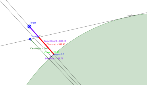
Have a look at this interactive simulator. Move the "Camera" and the "Target" around:
https://www.geogebra.org/material/iframe/id/1153831

You can move the camera very close to the Earth's surface to make the "Obscured" value approximate "drop" calculations. But note also the "Bulge" value.
View attachment 20123

View attachment 20124

Really though you are not laying down with your eye one inch above the surface. So your height does come into play.
View attachment 20125
 
Last edited:
Yeah that is very good. It still needs something more.

We need to opensource the code somehow.

-The distance camera target should be on it.
-Zooming with mouse scroll wheel in and out.
-It already can position: camera, target and earth by dragging, but it also needs a way to input two numbers by hand then push button: calculate the rest.
-Dimensions: metric? Meter? Dunno. Has to be on it.
-switch metric/imperial
-'show me the math' button
-Remove bug: only count as 'hit' if target line crosses camera line after horizon. Before horizon, 'Obscured' should be zero:
bug01.png

Then we have to think about implementing refraction I guess... hmmmm..
 
Last edited:
Hi Mick,

I didn't know how to post in this general thread without replying to a specific posting so I am just doing it here. I have a question regarding the image at the bottom of the page with the calculator that you built. https://www.metabunk.org/curve/
Is the secant line labeled "distance" just drawn from the point where the person is standing to some arbitrary point on the circle or is there some significance to that other point?

The other point is where the object being viewed is. Like, for example an island, a distant shore, a ship or a lighthouse.
 
The other point is where the object being viewed is. Like, for example an island, a distant shore, a ship or a lighthouse.
Apologies if this has been covered, but something strikes me as a fundamental missed assumption of the calculator: the distance is not the linear distance between the two points. It is actually the length of the ARC between the two points. Maps are drawn by measuring the Earth's surface, the geoid, and will give the distance between two points as the length of the Earth's arc between them. Your calculator will consistently underestimate the blocked-off amount of the object as the linear distance is always less than the arc length, and this will get very much worse as distance increases.
 
Apologies if this has been covered, but something strikes me as a fundamental missed assumption of the calculator: the distance is not the linear distance between the two points. It is actually the length of the ARC between the two points. Maps are drawn by measuring the Earth's surface, the geoid, and will give the distance between two points as the length of the Earth's arc between them. Your calculator will consistently underestimate the blocked-off amount of the object as the linear distance is always less than the arc length, and this will get very much worse as distance increases.
For under 200 miles it's a negligible difference. And if you click on "advanced" it will give you both numbers.

e.g. 200 miles, from 20 feet elevation:
https://www.metabunk.org/curve/?d=200&h=20&r=3959&u=i&a=a&fd=60&fp=3264
External Quote:
Hidden is the amount of the distant object hidden by the curve of the Earth
Hidden = sqrt(a*a - 2*a*d + d*d + r*r)-r = 4.78 Miles (25217.41 Feet) 4.776025247845488 Miles (25217.413308624178 Feet)

The following is the hidden amount calculated using slightly more complex trig
And assuming the 'distance' is the distance across the surface of the earth
This is more accurate for large distances and heights
But essentially the same for distances under 100 miles
True hidden = r/cos( d/r - asin(sqrt(h*(2*r+h)) / (r+h) ) ) - r = 4.78 Miles (25258.03 Feet)
 
I don't think this has been posted yet: a genuine mirage of the Chicago skyline, where the buildings appear upside down:

b2427b51c53fb65c5805de077bf33de4.jpg

Source: https://eu.freep.com/story/news/loc...irage-chicago-skyline-lake-michigan/70902190/

I know this thread is all over the place, and probably getting ready to be shut down - but can I just recommend a browse through as a nostalgia trip? It's so sweet to go back to the days when so many of us were flat earth novices and the now famous curve calculator was little but a glint in its daddy's eyes. :)
 
Last edited:
In this thread and elsewhere it has been mentioned that the curvature of the horizon was visible from the Concorde airliner, flying at over 50,000 feet. Just to confirm this, I was watching the BBC's Antiques Roadshow yesterday, in an episode filmed at the aerospace museum in Bristol. At around 13 minutes into the programme the presenter, Fiona Bruce, interviewed Captain Les Brody, the last British pilot to fly the scheduled Concorde services. Fiona Bruce asked Captain Brody if he could see the curvature of the earth from the cockpit, and he replied 'You certainly could'. For those who can access it, the programme is available here for the next month. https://www.bbc.co.uk/iplayer/episode/m0002twy/antiques-roadshow-series-41-9-aerospace-1
The relevant passage is at about 13min30 seconds.
Of course, there is nothing new or surprising in this, but it may be useful to record this definite 'witness statement'. Someone more techy than me might even make a little video meme out of it!
 
I often use that on laptop, just scrolling it up to the bottom or top of a window. A good way to check to see if an image needs levelling up too.

Also noticed looking at the above that there is a bit of distortion at the right of Wolfie's image, where the curve appears to level up a bit.
 
Last edited:
The days of curved CRTs are over, you can just hold a ruler (or the edge of a piece of paper) up to the screen. No computer skills required, though it helps when you're doing it on something bigger than a smartphone.
image.jpeg

I know they make curved LCDs now, shut up.
 
Last edited:
Back
Top