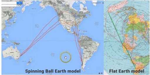
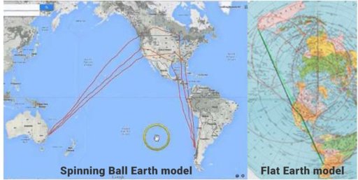
Flat Earth Theory Debunked by Short Flights (QF27 & QF28) From Australia to South America

Could you explain what you mean by this, and what you think the LoA means for the flight we are talking about? Metabunk deals with claims of evidence, not vague innuendos.

How does this have any bearing on the length of the flight between Australia and South America?
Yes, I would like an explanation for that little comment too. I would just like to point out that this LoA was in 2005. Qantas having been flying from Sydney to San Francisco since 1959. so what is the relevance of NASA?
 
Yes, I would like an explanation for that little comment too. I would just like to point out that this LoA was in 2005. Qantas having been flying from Sydney to San Francisco since 1959. so what is the relevance of NASA?

NASA is lying to the world and convincing them the world isnt flat, because NASA is the only space agency on the disk world.
 
Here is what I found. Supposedly they flight based on FE is almost twice the distance as the globe model. Nonstop flight being 12h 40m long. Same flight with one layover on the way is a total of 14h 15m (FLIGHT TIME) Thats enough time to land and depart. I'm strictly talking flight time.

So where NASA comes into play, they are showing a direct nonstop flight through the Southern hemisphere via their little seat TV's where in fact the are using the Flat Earth map as the actual route. Please chime in.


6:45p to 11:55p 3h 10m
Sydney to Auckland
Kingsford Smith Intl. (SYD) to Auckland Intl. (AKL)
Qantas Airways 149 operated by Qantas - Jetconnect
Economy / Coach (S)
BOEING 737-800 (WINGLETS) PASSENGER
layover 18h 20m stop Auckland (AKL)
6:15p to 2:20p 11h 5m
Auckland to Santiago
Auckland Intl. (AKL) to Arturo Merino Benitez (SCL)
Qantas Airways 321 operated by Latam Airlines Group
Economy / Coach (S)
BOEING 787-9

It's not at all clear what you are talking about here. This thread is about QF27 and QF28 which are direct flights between Sydney and Santiago:
https://flightaware.com/live/flight/QFA27
20170330-111320-ivkag.jpg

https://flightaware.com/live/flight/QFA28
20170330-111358-8900k.jpg

It's about 12 hours flying to Sydney, and 14 hours back, due to winds.

There are other flights (or connecting routes) that make a stop in Auckland. The Auckland to Santiago leg is still a long great circle route.

So what's your point?
 
So where NASA comes into play, they are showing a direct nonstop flight through the Southern hemisphere via their little seat TV's where in fact the are using the Flat Earth map as the actual route. Please chime in.

If they used the "Flat Earth map as the actual route" (by which I assume you mean a straight line on the Flat Earth map) then the route would head northeastwards up the coast of Australia instead of southeastwards towards New Zealand, then across the USA and Central America, then over the Andes, heading roughly southwards down South America. Don't you think the passengers might notice if they were flying over, say, Oregon when the seatback TV told them they were near Antarctica?

The white line is the great circle route. Are you suggesting it actually flies the red route?

upload_2017-3-30_19-26-59.png
 
So in conclusion, studying the FE map, the travel is decreased the closer you fly to the North Pole. The globe model is simply the FE model presented in 3d and appears to make the distance points much farther away. Could this possibly be an indicator that both maps are incorrect? Or does the theory of flying closer to the North Pole seem more logical?

Side note, flight Q27 is never tracked on flighttracker radar.

Flat Earth South America To Australia Flight Path.jpg

You are not making any sense at all. Have a look at the routes on a globe.

QF27 IS tracked. It flies the expected great circle route.
20170330-113802-hwpx6.jpg
 
So in conclusion, studying the FE map, the travel is decreased the closer you fly to the North Pole. The globe model is simply the FE model presented in 3d and appears to make the distance points much farther away. Could this possibly be an indicator that both maps are incorrect? Or does the theory of flying closer to the North Pole seem more logical?

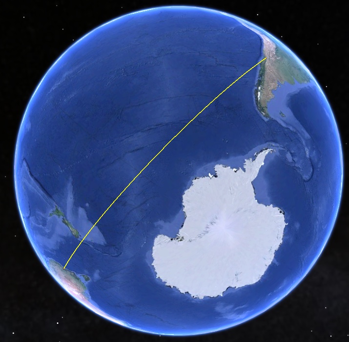
If you are flying from Australia to South America, both of which are in the southern hemisphere, then you don't want to fly anywhere near the North Pole! The map on the left is not a "Spinning Ball Earth model". It is a Mercator projection. If you want to see the shortest distance on the globe, use a globe:


Side note, flight Q27 is never tracked on flighttracker radar.
It is untracked for part of the route, like lots of flights. That's because it is flying across the Southern Ocean. Who would be tracking it?
 
You are not making any sense at all. Have a look at the routes on a globe.

QF27 IS tracked. It flies the expected great circle route.
20170330-113802-hwpx6.jpg

Not only that, but if you live in the South Island of New Zealand, you can watch it (or its return flight QF28) flying overhead, following the great circle route. Like this:

upload_2017-3-30_19-43-15.png

(Source on Flickr)


Checking the playback on Planefinder.net shows that QF28 did indeed fly right over Christchurch at about 16:40 local time (UTC+13) on March 20 last year:

upload_2017-3-30_19-51-41.png
 
Last edited:
You are not making any sense at all. Have a look at the routes on a globe.

QF27 IS tracked. It flies the expected great circle route.
20170330-113802-hwpx6.jpg

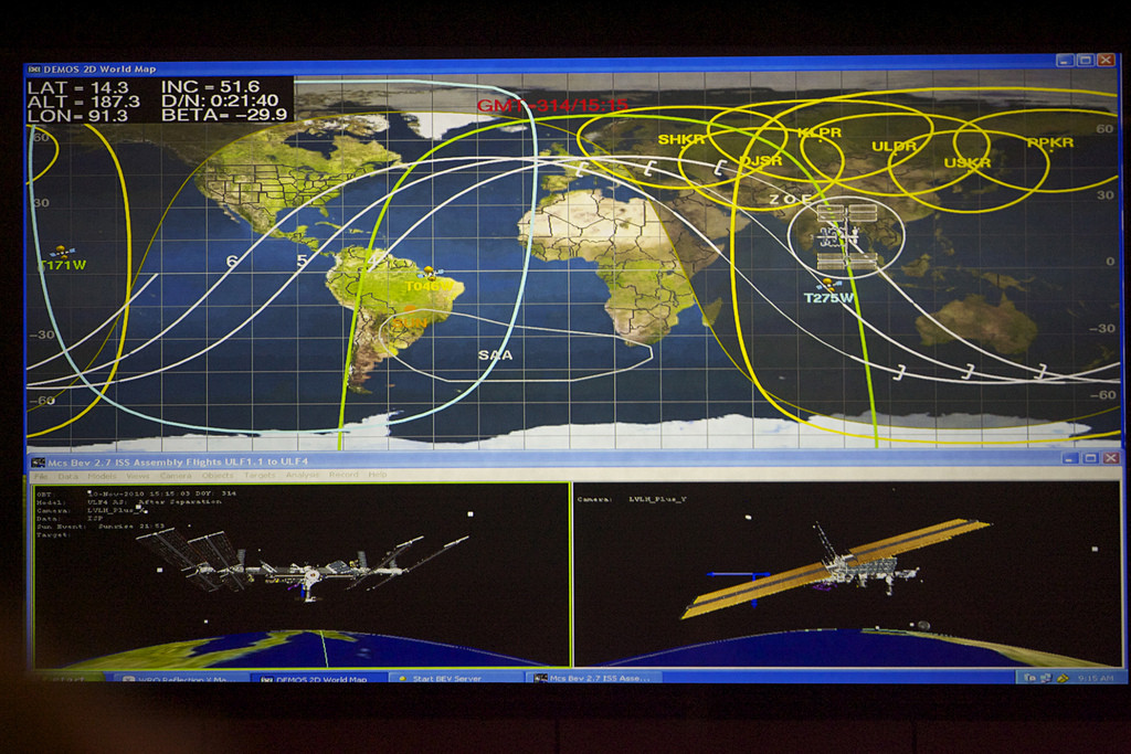
Mick, are you aware of any animations or software that could animate a flat object ( like the map you have here with the track) that could curl and show how the curved line "straightens" on a curved surface? I think part of the misunderstanding is why the track line is always shown as a curve rather than an actual line when its on a flat map. I could be mistaken but I think the NASA confusion is also coming from the wavy lines you see on the flat maps of Earth in Mission Control that plot the projected course of orbiting craft (see below).

 
Mick, are you aware of any animations or software that could animate a flat object ( like the map you have here with the track) that could curl and show how the curved line "straightens" on a curved surface?

Well you can use the "Measure distance" tool on Google Maps to plot the line between Sydney and Santiago:

upload_2017-3-30_19-58-23.png

Then if you switch to "Earth" view it shows the globe instead of the Mercator projection:

upload_2017-3-30_19-59-7.png

Which you can then zoom in on and rotate to see that it is indeed the shortest distance between the two points.

upload_2017-3-30_20-0-9.png

I get that, but what Im looking for is an actual visual show the mechanics behind the curved line, why it exists and why a curved line on a globe is, in reality, a "straight" line. Does that make sense?
 
I get that, but what Im looking for is an actual visual show the mechanics behind the curved line, why it exists and why a curved line on a globe is, in reality, a "straight" line. Does that make sense?
I don't really see how it can be made plainer than plotting a great circle route on a globe and looking at it from different angles. When you place your eye directly over the line (i.e. the line passes between your eye and the centre of the globe) then the line looks straight. That's just perspective, really, rather than anything mysterious.
 
I don't really see how it can be made plainer than plotting a great circle route on a globe and looking at it from different angles. When you place your eye directly over the line (i.e. the line passes between your eye and the centre of the globe) then the line looks straight. That's just perspective, really, rather than anything mysterious.

Yes, but we're also thinking of it in terms of someone that takes for granted 3 dimensional plotting on a globe as a given. To someone that believes the earth is a disk, a curved line makes no sense. We can show them globes and -explain- why it happens, but a visual representation of taking a plotted curved line and applying it to a sphere would re-enforce the explanation. Most humans are visual.. showing them something rather than explaining it generally has a deeper impact. Im not trying to be obstinate I promise, Im just thinking lowest common denominator.
 
Yes, but we're also thinking of it in terms of someone that takes for granted 3 dimensional plotting on a globe as a given. To someone that believes the earth is a disk, a curved line makes no sense. We can show them globes and -explain- why it happens, but a visual representation of taking a plotted curved line and applying it to a sphere would re-enforce the explanation. Most humans are visual.. showing them something rather than explaining it generally has a deeper impact. Im not trying to be obstinate I promise, Im just thinking lowest common denominator.

Maybe you could draw a diagram showing what this would look like?
 
Side note, flight Q27 is never tracked on flighttracker radar.

Flat Earth South America To Australia Flight Path.jpg

Yes it is. We get tracked when we leave Sydney. We often fly over New Zealand where we get tracked and when we reach South America we get tracked again.

Side note: Flight trackers don't use radar. They use the ADSB system.
 
Maybe you could draw a diagram showing what this would look like?
Ive tried making animations in Blender or in Autodesk and they never turns out well, which is why I was hoping youd seen or knew of something that was already rendered that could provide the example. Drunk monkey paintings make more sense.
 
FE MAP AUSTRALIA 2.png Well with all due respect I understand many of you have taken this flight and it has been a huge thorn in the side of the FE community, however the common end factor is the flight is too long and wouldnt have enough fuel. The actual flight is roughly 7,200 miles. Here is the distance on a FE map using proper Equi-Distance measurements. Your flying the same route minus the NASA created globe GPS nonsense. The purple line shows the FE flight path

"We get tracked when we leave Sydney. We often fly over New Zealand where we get tracked and when we reach South America we get tracked again."
The flight is too long? Then how does the flight get there? Happens every day.
 
FE MAP AUSTRALIA 2.png Well with all due respect I understand many of you have taken this flight and it has been a huge thorn in the side of the FE community, however the common end factor is the flight is too long and wouldnt have enough fuel. The actual flight is roughly 7,200 miles. Here is the distance on a FE map using proper Equi-Distance measurements. Your flying the same route minus the NASA created globe GPS nonsense. The purple line shows the FE flight path

"We get tracked when we leave Sydney. We often fly over New Zealand where we get tracked and when we reach South America we get tracked again."
It's not even clear what you are trying to say here. Are you suggesting the plane flies the purple route, or the series of three straight lines (3 x 2,600 miles = 7,800 miles according to your map, but you don't explain how you measured this), approximating the great circle route?

If you claim the flight takes the purple route, then can you explain why it passes over New Zealand, as confirmed both by passengers and by people on the ground photographing it flying overhead? Your purple line goes nowhere near New Zealand, it heads almost northwards out of Sydney and passes closer to Papua New Guinea than NZ!
 
FE MAP AUSTRALIA 2.png Well with all due respect I understand many of you have taken this flight and it has been a huge thorn in the side of the FE community, however the common end factor is the flight is too long and wouldnt have enough fuel. The actual flight is roughly 7,200 miles. Here is the distance on a FE map using proper Equi-Distance measurements. Your flying the same route minus the NASA created globe GPS nonsense. The purple line shows the FE flight path

"We get tracked when we leave Sydney. We often fly over New Zealand where we get tracked and when we reach South America we get tracked again."

Like others, I find it hard to work out what you are claiming, and what evidence you have for your claims, for example that the flight at issue would be impossibly long.

However, the flat earth map you show clearly contradicts the everyday experience of people living in the southern hemisphere. For example, it shows Australia to be nearly 3 times as long east-west as it is north-south. I've never found any Australian or foreign visitor who would believe that!


The same with Africa on your favoured FE map. Measure the distance across the waist of the continent from Namibia to Maputo. According to your FE map,Africa from north to south is only this East west distance is only about 1.8 times this east-west distance. In reality, travellers confirm that it about 5.5 times as far N-S as E-W! How can we even begin to use a map with such obvious errors to discuss distances?

http://roundearthsense.blogspot.co.uk/2016/03/ifthe-earth-were-truly-globe-then-every.html

By the way, on your flat earth map, a person standing on the southern tip of Africa and looking South would be looking "rimwards" at an angle of about 70 degrees (or towards 2 o'clock if we take your map as a clock face) .

But someone looking southwards while standing at the southern tip of South America on your map would be looking rimwards at about 160 degrees (roughly 5.30 on a clockface).

The problem is, they see the same stars and constellations in front of them in the southern skies. Yet your proposed flat earth maps says that they are looking in different directions by around 90 degrees!

How can the southern skies appear the same when viewed in two horizontal directions at right angles to one another?
 
and mark Sydney to Perth, 2,444 miles while drawing a line from the Atlantic coast of Brazil to what looks like somewhere in Southern Chile. Wrong continent. Geography is obviously not your strong point.
 
Last edited:
Because the map is not the map of FE, but, in fact, a very special projection of the globe?
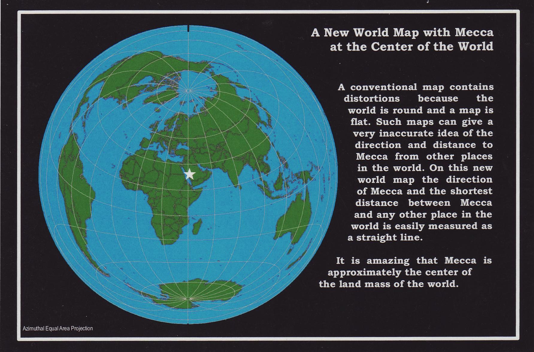
https://en.wikipedia.org/wiki/Azimuthal_equidistant_projection

It's one of he simplest polar projections of the globe (in terms of creating it on a computer, or even by hand). Although arguably it's a projection of a equirectangular projection of a globe.

I'd just read this paragraph a few minutes ago:


azimuthal equidistant projection of the Earth, with the North Pole as the origin point [...] [is]
nearly the model proposed in Zetetic Astronomy (though Rowbotham was more careful and corrected the land mass distortions, opting for distorted distances between the continents

Brooks, Gordon S. (2016-02-06). The Earth Is Not Flat (Kindle Locations 84-85). . Kindle Edition.
Content from External Source
Rowbotham's map is this:
20170420-083725-uaihi.jpg
Correcting the land mass shapes so they are roughly the correct size relative to the northern hemisphere fixes problems like the distance from Perth to Sydney. It introduces loads more problems, of course, but in the context of this thread it just makes the flight even longer.

There's a few more versions of Rowbotham's map n Zetetic Astronomy:
20170420-084144-4tx3k.jpg

I don't think this was a particularly rigorous attempt at a map, but it illustrates on the of the fundamental issues with the FE theory - you can't draw a flat map that matches reality.
 
FE MAP AUSTRALIA 2.png Well with all due respect I understand many of you have taken this flight and it has been a huge thorn in the side of the FE community, however the common end factor is the flight is too long and wouldnt have enough fuel. The actual flight is roughly 7,200 miles. Here is the distance on a FE map using proper Equi-Distance measurements. Your flying the same route minus the NASA created globe GPS nonsense. The purple line shows the FE flight path

"We get tracked when we leave Sydney. We often fly over New Zealand where we get tracked and when we reach South America we get tracked again."

Quick question... If the actual flight you're showing is accurate, why dont passengers see Mexico or the Coast of Southern California.. Like San Diego? US Marine Boot Camp is in San Diego, and can be seen by aircraft flying over head (you can see and hear flights taking off from the nearby airport as well). Why dont air traffic controllers in San Diego squawk the flights from NZ and Australia as they fly into their airspace?
 
A better way is to debunk flat earth is to explain you can't chase a setting sun via flat earth. Only if the Earth had curvature, would it be possible to chase the said setting sun. Ps. Done it on flight from perth to sydney. Longest sunset ever in my life. It was beautiful.
 
Yeah exactly. Here I have broken it down to show true Equi-Distance compared to the full map.FE MAP AUSTRALIA 2 FINAL.png

Here I have plotted that approximate path (purple line) on a map of the real world. That route is about 14,000 miles long, or roughly twice as far as the actual Sydney to Santiago route.

upload_2017-4-21_11-56-22.png


Looking at it from the south shows how inefficient this route would be:

upload_2017-4-21_12-0-56.png

Compared to the actual great circle route:

upload_2017-4-21_12-3-54.png
 
Last edited:
I think maybe @camosy meant Sydney to Perth?

Yes, any westward flight is where this happens.
Twice I have taken off about a minute after sunset and had the sun rise in the west as we climbed and headed towards Perth. The second sunset took almost an hour to occur. That can only happen with curvature.

Psilguy, this is all fascinating but it doesn't match reality. I operate the direct flights to Chile and back. None of what you say is what happens in real life. We head towards the south polar regions and the flight is well within the range of a 747-400.

That is the reality.
 
A better way is to debunk flat earth is to explain you can't chase a setting sun via flat earth. Only if the Earth had curvature, would it be possible to chase the said setting sun. Ps. Done it on flight from perth to sydney. Longest sunset ever in my life. It was beautiful.

As far as I can tell from the geometry, the sun doesn't set at all on a flat earth.
 
Has anyone ever flown non-stop from Perth, AU to Buenos Aires, AR? This trip would be approximately 7800 miles and would cross very near the South Pole. This distance is shorter than a great circle route, non-stop flight from Bangkok to LAX (which used to be an every day occurrence).

Perth to Buenos Aires.jpgAlso, is there any video (time lapse) of a satellite going right over the South Pole?
 
Is there a flight that follows that route?
I asked that same question and the answer I ended up with was no. There's all kinds of laws (ETOPS law) and regulations about flying in antartica. For example
Planes flying below 72 degrees latitude need special survival equipment on board.
https://aviation.stackexchange.com/questions/33938/do-any-flights-go-over-the-south-pole
Content from External Source
And from what I can find no one flies non-stop Perth to Buenos, but I may not be looking hard enough.
 
Last edited by a moderator:
Back
Top