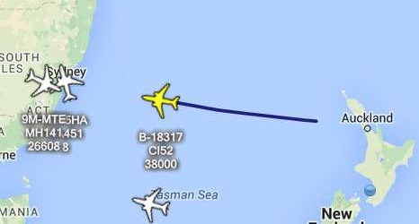
Flat Earth Theory Debunked by Short Flights (QF27 & QF28) From Australia to South America

Mick West

Administrator
Staff member
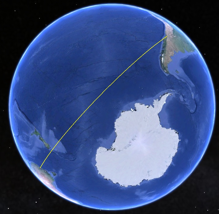
To debunk the Flat Earth theory, you can just use Sydney to Santiago, Chile, Quantas flight 27, 7000 miles. 12 hour flight. This flight would be impossible on the Flat Earth model, requiring the plane to travel at twice the speed of sound.
20150703-122854-zamuk.jpg


20150703-123118-xt1h9.jpg


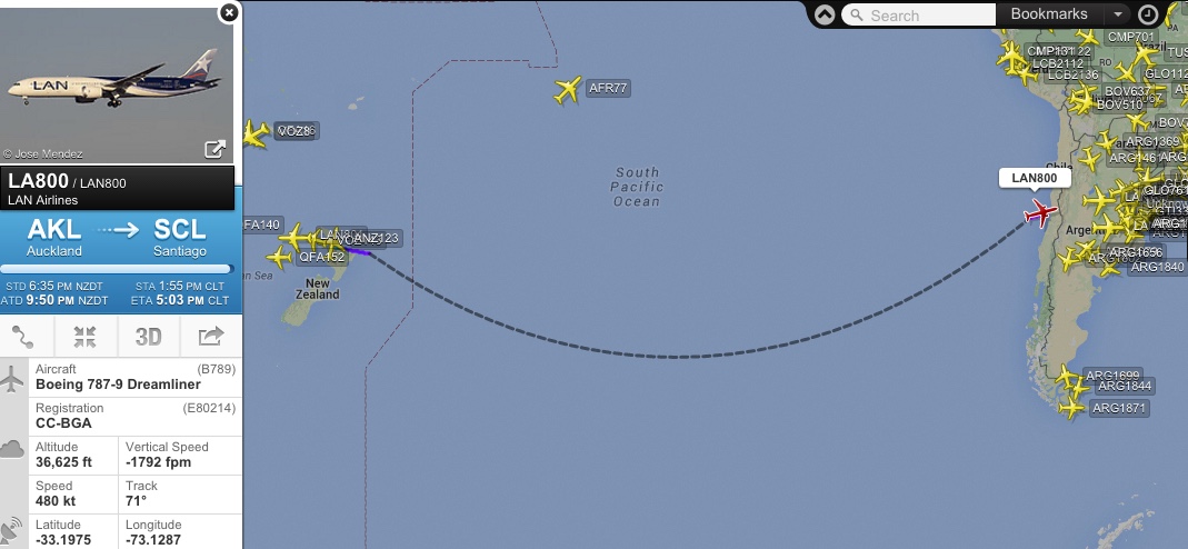
Santiago is the furthest south South American city with direct flights to Australia. There are also flights to and from New Zealand.
20160203-113851-obmug.jpg


A similar thing is Johannesberg, South Africa, to Perth, Australia. A short 9 hour flight in the real world, but impossibly long on a Flat Earth.


View attachment 19396

View attachment 19397

Yet people don't realize there are these flights, and claim this as evidence.
External Quote:
The misunderstanding here is the idea that the flights "Stop Over" in Dubai. They don't. You make a connection in Dubai (or other places) - i.e there are two different flights. There is simply not that much call for flights from Johannesburg to Perth, so you (mostly) have to get there with connecting flights via a larger hub airport.

There are really only four cites that have flights near Antartica:
  • Sydney, Australia
  • Auckland, New Zealand
  • Santiago, Chile
  • Johannesburg, South Africa.
Sydney and Auckland are fairly close, and so the three regions form a triangle around the South Pole.
ScreenFlow.gif


See also this practical demonstration, where the pilot of a Quanta jet videoed the sea ice, and then matched it with satellite images.
https://www.metabunk.org/a-flight-over-the-antarctic-sea-ice-from-chile-to-australia-qf28.t8235/
 
Last edited:
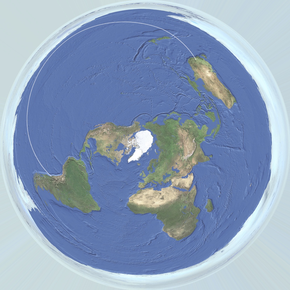
It's even worse than a simple straight line on the flat surface would suggest. If you take the great circle route (which they would have to take to "pretend" to be on a globe), then the route looks like this:
20150703-151608-1j9wq.jpg


About three times as long as Santiago to London, when it's actually a much shorter flight.
 
I fly for Qantas Chris, although not on the 747 which does that route. The flat earth does not work for people like me.

I can tell you that the QF28 (Santiago to Sydney) is airborne as I write this. It has a planned flight time of 13 hours 27 minutes and a planned distance 6347 nautical miles.

Here is the planned route, currently the aircraft would be approaching the 70 degree South waypoint. The guidance system is linked to GPS receivers and inertial systems. I fly over a globe, otherwise none of what I do would work. Simple as that.

image.jpg
 
The flights exist in the system but when I tried to book them I could not. I tried with 3 different companies online, untill I resorted to phoning them. Although there are nonstop flights inside the database on booking they are not available. Everyone most make a pitstop.

Also to counter-debate the argument made that we would have to fly longer. Actually that's pretty illogical sounding to me, why would you need to fly a curve on a flat plane? Just flying straight wouldn't matter - you are above the clouds. They always fly in predominantly a straight line for majority of the flight also on all flights because point to point is the fastest most fuel efficient way to fly.

Thanks
 
The flights exist in the system but when I tried to book them I could not. I tried with 3 different companies online, untill I resorted to phoning them. Although there are nonstop flights inside the database on booking they are not available. Everyone most make a pitstop.

Please provide screenshots demonstrating this.
 
Actually that's pretty illogical sounding to me, why would you need to fly a curve on a flat plane?

To keep up the illusion that the Earth is not flat. Otherwise you'd leave Sydney heading north instead of east and during your journey pass over/near land that looks strangely like California instead of the Antarctic.
 
Also to counter-debate the argument made that we would have to fly longer.

Flying longer is just the natural consequence of believing in a flat model of the earth which has two and a half times the surface area of the spherical model.
 
I was having a discussion with someone who claimed that the LAN flights between Auckland and Santiago are "always cancelled two days before the flight".

But there are videos of people flying the route on YouTube, for instance:


and


There is one flight a day in each direction and the scheduled duration is 11 hours 20 minutes:

upload_2015-11-26_19-21-1.png


Looking at the most recent flight, on Nov 26:

Actual time of departure, 1921 NZDT (UTC +13) = 0621UTC.
Actual time of arrival, 1411 CLT (UTC -3) = 1711UTC.

Actual flight time was 10 hours 50 minutes.

The great circle distance is 6,005 miles, giving an average speed of 554mph. The cruising speed of a Dreamliner is 567mph.


Edit: note that this LAN flight (including the Sydney-Auckland leg) is the same one as QF321 in the screenshot in post 7 above: it's a codeshare.
 
Last edited:
http://www.travelandtourworld.com/news/article/qantas-celebrates-3-years-flying-santigo/

External Quote:
"Qantas today celebrates the third anniversary of its first service from Sydney to Santiago, with more than 430,000* Qantas passengers travelling on the route since launch.

Initially operating three times per week, Qantas began services from Sydney to Santiago in 2012 and increased to four services per week last year in response to strong passenger demand.

Qantas Executive Manager Global Sales, Stephen Thompson said thousands of customers were taking advantage of Qantas' vast South American network every year.

"Demand for flights between Australia and Santiago has exceeded our expectations and forward bookings are looking very strong," said Mr Thompson.

"The strong business market, which makes up around two thirds of our customers, together with the growing family, student and leisure segments makes Santiago a very important hub.

'Qantas offers the fastest non-stop route between Australia and South America, and our recent expansion with oneworld partner LAN enables customers to travel to more destinations in South America, more opportunities to earn frequent flyer points and have their luggage checked through to their final destination.' "


http://www.airnewzealand.co.nz/press-release-2014-air-new-zealand-to-fly-direct-to-argentina

External Quote:
"Air New Zealand has today announced it will launch direct flights between Auckland and Buenos Aires, Argentina - the airline's first ever scheduled service to South America.

An Air New Zealand Boeing 777-200 aircraft will operate three return services a week on the route all year round.

Air New Zealand Chief Executive Officer Christopher Luxon says the new destination, the airline's 28th international port, opens up an exciting new world for travellers from both New Zealand and Australia.

"South America was once the domain of the intrepid explorer, but the direct service to Buenos Aires, with a flight time of around 12 hours, means a quick and action packed getaway is now a reality."


http://www.flysaa.com/us/en/flyingSAA/NewsLetters/archive/January2010.html

Daily non-stop flights between Johannesburg, South Africa and Sao Paulo, Brazil

South African Airlines January Newsletter

"SAA would like to wish all our subscribers a Happy New Year! And what a year this promises to be, with the world landing on our doorsteps for the much anticipated 2010 FIFA World CupTM. With more flights and a wider network than any other local carrier, we look forward to what will probably be our busiest year ever. Why not start the year on a good note and plan ahead, booking your flights well in advance? Did you know that if you book early, our Saver option often proves to be the most affordable flight, with the added benefit of an all inclusive ticket cost

The long-lasting impression most visitors leave Brazil with is of carefree, colourful people dancing and celebrating in the street parades at Carnaval, and of a passion for life and exuberance of spirit that charms visitors from around the world. Tourists descending on the country's fabulous cities, such as hedonistic Rio de Janeiro, can enjoy the five-star hotels, shopping malls, beautiful beaches, sunny skies and inspirational restaurants without really having to confront the hundreds of shantytowns (favelas) where the poorest of the poor eke out a living in the shadows of the skyscrapers.

Did you know?

SAA offers direct flights from Johannesburg to Sao Paulos Guarulhos International Airport DAILY


Non-stop flight SA222 departs Johannesburg daily at 10h30 and arrives in Sao Paulo at 16h00 local time the same day, permitting very good connections to the main South American destinations.


SAAs return non-stop flight from Sao Paulo departs at 18h00, returning travelers to Johannesburg at 07h30 the following day.


SAA operates the Airbus A340-600 on the route, with individual, on-demand entertainment systems, a pillow, blanket and amenity kit in every seat4 additional regular weekly flights to SAO from 02 June 2010 with A342 aircraft. Flights will operate on Mondays, Wednesdays, Fridays and Sundays."
 
Last edited by a moderator:
In the end, they will say that YOU have to PROVE those vids of flights aren't fake. :rolleyes:

I wonder if we could take a trip that works in a long-distance flight, that can prove the world is a globe, AND finish the flight in South Africa to visit @Rongram and witness his free energy device and collect his $20k bet at the same time :P :P :P.

Two birds, one expensive, round the globe, stone.
 
It's even worse than a simple straight line on the flat surface would suggest. If you take the great circle route (which they would have to take to "pretend" to be on a globe), then the route looks like this:
20150703-151608-1j9wq.jpg


About three times as long as Santiago to London, when it's actually a much shorter flight.

In any case those making this claim must explain why every long haul airline in the world wastes enormous amounts of fuel flying great circles when a straight line would be the shortest route on a flat planet.
 
There are 100's of compliments and complaints on this flight so it must be real. Unless all those complaints sites are fake.. Easy answer to any problem they cant solve.. ITS FAKE! LOL
 
There are 100's of compliments and complaints on this flight so it must be real. Unless all those complaints sites are fake.. Easy answer to any problem they cant solve.. ITS FAKE! LOL
Oh and a friend of mine lives in Australia and has flown Johannesburg to Sydney more than once in around 13 hours, with flat earth this wont be possible in 13 hours unless they have special conspiracy planes which fly double the speed...
 
For 34 years, until April 2014, Aerolineas Argentinas had a transpolar flight from Ezeiza [Buenos Aires in Argentina] to Sydney.


Unless tens of thousands of people had been recruited to lie about taking that flight, the earth is a sphere.
 
Last edited by a moderator:
For 34 years, until April 2014, Aerolineas Argentinas had a transpolar flight from Ezeiza [Buenos Aires in Argentina] to Sydney.


Unless tens of thousands of people had been recruited to lie about taking that flight, the earth is a sphere.


Not quite transpolar, but still the point stands.
20160221-121723-mj0jm.jpg
 
Hmmm if I fly west all northern hemi... i can go around the world 1/2 way in 21 hours with stops and I arrive 16,000 odd miles and 12 hours later then I left ....the way home 21 hours traveling, but I arrived 3 day's later... flat earth explain please
 
One of the claims is that GPS is actually carried out by ground based transmitters instead of satellites.

NEXRAD in the US had 160 radars that give almost 100% coverage of the CONUS landmass.

At approximately 1.6% of the Earth surface, this works out rather neatly that approx 10000 fixed based GPS transmitters would be required for global coverage.... 7700 of them in the oceans.

On land you need to take into account the terrain masking of signals as well so more needed.

Apart from the obvious point that no photos of these installations exist or that there is any evidence of an organisation that maintains them, it must be remembered that GPS is primarily a weapons targeting system that has a useful secondary function that is easily interruptible by the US military, that of civilian navigation.

That is why the Russians, Chinese Indians, Japanese and Europeans are creating their own GPS systems.
 
Not really. LORAN C covered most of the world with only 75 stations (each with 2 or more slave stations). OMEGA covered the entire would with 8 stations but it required a big VLF antenna that would not fit inside any GPS receiver. But both of those systems relied on very sloppy ground wave propagation so were no match for GPS' accuracy no matter how technologically advanced your receiver was.

The biggest shortcoming of the "ground-based GPS" claim of the flat earthers is the determination of altitude. An aircraft would have to be fairly close (within 50 miles for cruising altitude) to a ground-based transmitter just to get a rough altitude. GPS provides accurate altitude in the middle of the ocean, something only a satellite-based system could provide.
 
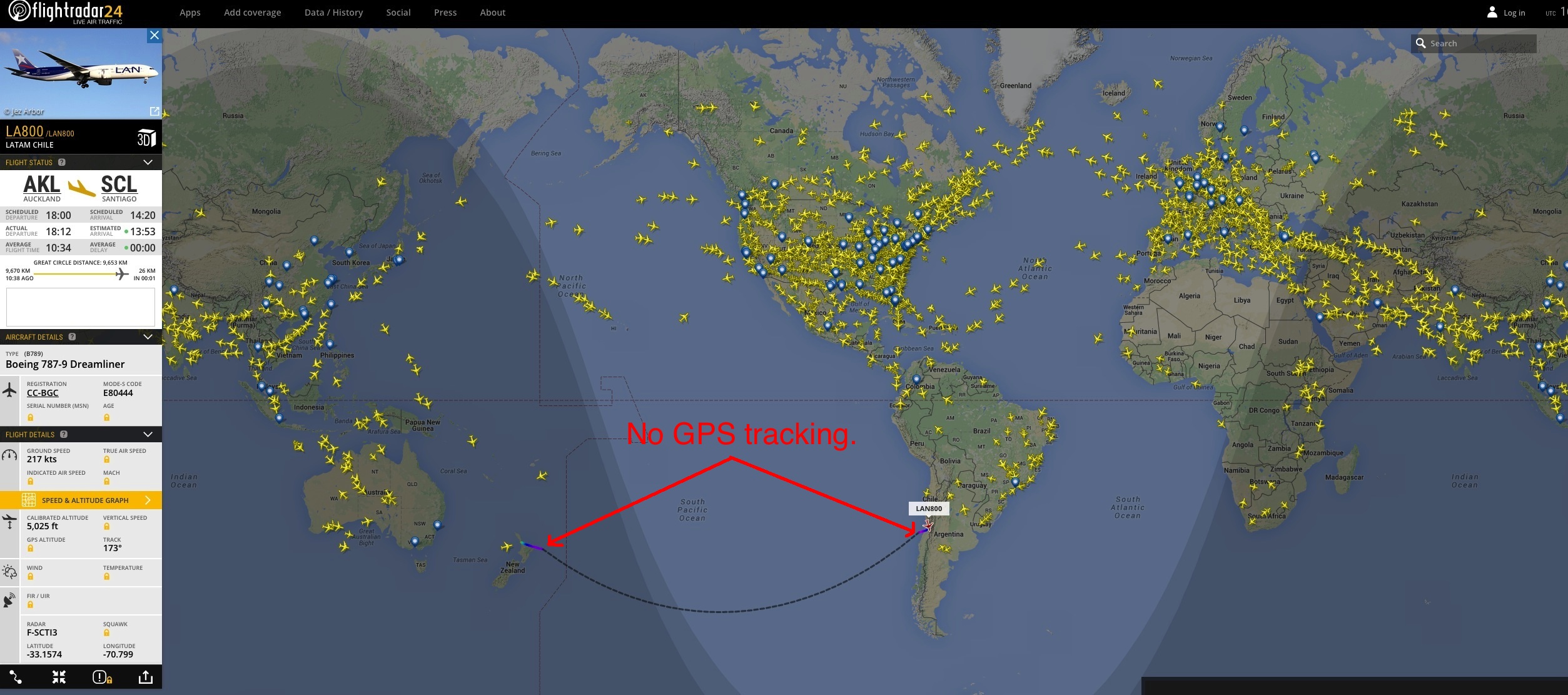
So my question is, why are those oversea flights not tracked by flightradar24 or others?

Is there maybe no GPS "coverage"?

Above the equator the oversea flights are well tracked.

4bbf6520abfca801a2ea4ba43bd1d81c.jpg
?
 
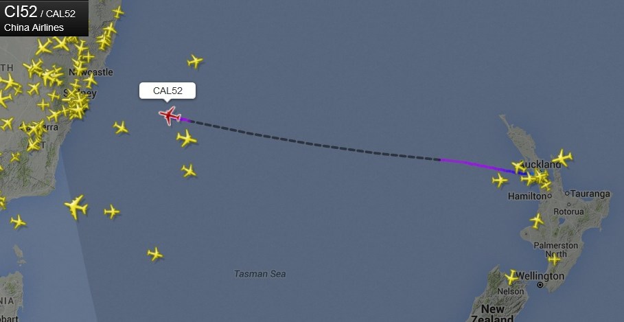
FR24 works mostly by a network of ADS-B receivers, which have limited range, and are all land based. So the flights are recorded over land, and just estimated elsewhere. Look at this track of qf24 from yesterday (click for full size)
https://www.flightradar24.com/data/flights/qf27/#9acc803
20160511-121028-l85yw.jpg


Notice it has recorded data over Australia, New Zealand, and Chile, but not over the ocean.

In the Northern hemisphere you see similar sections of the path with no data,
20160511-121545-ek8yn.jpg


however there are also sections of recorded data over open water. These do not use ADS-B, and presumably use Radar data, which is not available in the South:

https://www.flightradar24.com/how-it-works
External Quote:
North America Radar Data
In addition to ADS-B and MLAT, we also receive additional live data for flights in the North America. This data is based on radar data (not just aircraft equipped with ADS-B transponders) and includes most scheduled and commercial air traffic in the US and Canadian airspace, as well as parts of the Atlantic and Pacific Ocean.
 
Last edited:
They'll brief you on the deception. I bet that's part of the training.

At risk of feeding a troll…

Why don't you tell us what the deception actually is, and why every airline in the world that does long-haul flights buys into it at great cost?

Forget these particular flights for a couple of paragraphs. On a sphere, the shortest distance between 2 points is a great circle. Airlines use these to plan routes, give or take other constraints like areas where overflying is not allowed or safe. If every airline flying great circles converted to flying straight lines, they would save truckloads of fuel. If flatties are right and the rest of us wrong.

You would have to have an extraordinarily strong motive for this to be the case. So what is the motive? A conspiracy that costs airlines a huge amount of money? How can that possibly make sense? It obviously doesn't so perhaps you would be so kind as to post a link to someone who argues the case, as this takes us a bit away from the topic of the thread.

My wife BTW has been on one of these flights and it took exactly the advertised time (± the usual minor variation in flight times).

Oh and one more thing: how are we able to get satellite data if the physics required to place them in orbit and the very concept of an orbit is all wrong?
 
FR24 works mostly by a network of ADS-B receivers, which have limited range, and are all land based. So the flights are recorded over land, and just estimated elsewhere.

This might start changing soon. I've just read recently about software written by a hobbyist called JAERO which can be used to decode SatCom AERO signals, the same ones being received by companies like Inmarst for example. It's quite interesting and hopefullly will start being adopted by sites like FR24.

Since it's satellite based, the messages aren't as frequent as ADS-B but here's an example where he was able to track an aircraft in the FR24 "blackout" zone. Maybe it could finally put an end to the FE stuff or is that just wishful thinking?

http://jontio.zapto.org/hda1/c-band-planes-on-maps.html

6dd3be0824bca63113ab0e0ea24d11c2.jpg


cdc01ada8f83079700e657bee76786fa.jpg
 
Last edited:
I will be operating those particular flights in the near future. If anything fishy happens, I'll let you know!
Yeah, something fishy will happen. At local sunset, the surface below you will turn dark. Yet your plane will be in the sunlight for quite a few minutes, depending on your HAAT. Ask a flat Earther how that can happen. Hilarity ensues.

Seems like the more mathematically inclined could develop a formula to deduce the radius of the earth using the time difference. I'm sure somebody already has.
 
At risk of feeding a troll…

Why don't you tell us what the deception actually is, and why every airline in the world that does long-haul flights buys into it at great cost?

Forget these particular flights for a couple of paragraphs. On a sphere, the shortest distance between 2 points is a great circle. Airlines use these to plan routes, give or take other constraints like areas where overflying is not allowed or safe. If every airline flying great circles converted to flying straight lines, they would save truckloads of fuel. If flatties are right and the rest of us wrong.

You would have to have an extraordinarily strong motive for this to be the case. So what is the motive? A conspiracy that costs airlines a huge amount of money? How can that possibly make sense? It obviously doesn't so perhaps you would be so kind as to post a link to someone who argues the case, as this takes us a bit away from the topic of the thread.

My wife BTW has been on one of these flights and it took exactly the advertised time (± the usual minor variation in flight times).

Oh and one more thing: how are we able to get satellite data if the physics required to place them in orbit and the very concept of an orbit is all wrong?

The only reason why it cost so much is simple Fuel cost to fill that jet to make the trip.
 
Can you elaborate? It's hard to tell if you're agreeing or not.
I'm only stating that the cost for a flight is over 2k. Normal operation of any jetliner is very high with Jet A fuel costing over $4-$6 per gallon. So take that X 20,000 gallons per trip. It gets up there. So for taking direct flights is not that common.
 
Back
Top