Flat Earth Theory Debunked by Short Flights (QF27 & QF28) From Australia to South America

I'm only stating that the cost for a flight is over 2k. Normal operation of any jetliner is very high with Jet A fuel costing over $4-$6 per gallon. So take that X 20,000 gallons per trip. It gets up there. So for taking direct flights is not that common.

I'm still unsure whether you're arguing for or against FE. Are you saying that direct flights (Shortest FE route, across the Hub) are not common, which increases fuel costs, or simply making a general statement about how much fuel is used on transpolar flights?

If the first, what prevents an airline from cutting costs and time by using the direct route?

The 747-400s used on these flights can hold almost 50k gal of fuel, BTW.
 
A similar thing is Johannesberg, South Africa, to Perth, Australia. A short 9 hour flight in the real world, but impossibly long on a Flat Earth.


20160607-101226-msprw.jpg

20160607-101534-jtqli.jpg

Yet people don't realize there are these flights, and claim this as evidence.

CkTHyNLUgAA5NRf.jpg
Content from External Source
The misunderstanding here is the idea that the flights "Stop Over" in Dubai. They don't. You make a connection in Dubai (or other places) - i.e there are two different flights. There is simply not that much call for flights from Johannesburg to Perth, so you (mostly) have to get there with connecting flights via a larger hub airport.

Consider if I wanted to fly from Sacramento to Kansas City, MO. There are no direct flights, so these are my options:
20170430-120825-y8vr5.jpg
 
Last edited:
Any flight in the southern hemisphere with an appreciable east-west component disproves the flat earth model due to the complete absence of sonic booms that must accompany each flight. Flights from Sydney to Perth take a little over 5 hours. The FE distance between them is 4468 nmi. For those flights to arrive on time would require an average speed of Mach 1.53.
 
lights from Sydney to Perth take a little over 5 hours. The FE distance between them is 4468 nmi.

Isn't Australia roughly the actual shape in FE models? though they just had really big oceans in the south (outer disk)
 
Isn't Australia roughly the actual shape in FE models? though they just had really big oceans in the south (outer disk)

Yeah. I've seen one flat earther modify the azimuthal equidistant projection to make the width of the southern continents match the spherical model. Of course that just makes the Sydney/Santiago/Johannesburg flights even more ridiculously longer.
 
Yeah. I've seen one flat earther modify the azimuthal equidistant projection to make the width of the southern continents match the spherical model. Of course that just makes the Sydney/Santiago/Johannesburg flights even more ridiculously longer.

Yes I was going by the OP map, on the left here, compared with an azimuthal equidistant plot I made (from an equirectangular projection converted to polar). Compare Australias. 20160607-160449-41dpo.jpg
 
Yes I was going by the OP map, on the left here, compared with an azimuthal equidistant plot I made (from an equirectangular projection converted to polar). Compare Australias. 20160607-160449-41dpo.jpg
Two quick questions if i may. First, are planes allowed to perform flights over so large areas that they dont get to contact land services? Second, the FE flight route seems to be extremely close to antarctica, meaning that flatearthers on this flight would expect to see ice underneath them,right? So the route you show here must be wrong either way. Moreover, flat earth-wise, if its all sea, why not perform a shorter flight route, still making sure that only water would be visible from the plane? Then people would still think the earth is a sphere and the flight would take much less time, flat earth-wise again
 
Two quick questions if i may. First, are planes allowed to perform flights over so large areas that they dont get to contact land services?
Yes, like over the Pacific, or the North Atlantic.

Second, the FE flight route seems to be extremely close to antarctica, meaning that flatearthers on this flight would expect to see ice underneath them,right?
Yes, like in this video of the flight.

Source: https://www.youtube.com/watch?v=UaIiw0uKE-s


So the route you show here must be wrong either way.
Why?

Moreover, flat earth-wise, if its all sea, why not perform a shorter flight route, still making sure that only water would be visible from the plane? Then people would still think the earth is a sphere and the flight would take much less time, flat earth-wise again

Because in the flat earth model even the shortest route (which would be over the land of South and North America) would be longer than then actual route.
 
I'm doing that particular flight in a little over a week from now. If you have any questions, please ask.

Four engine aircraft have no restrictions on how far from land they can fly. I just completed a Sydney-Johannesburg-Sydney trip where, for large periods we were probably the most isolated people on the planet.

Increasingly neither do modern twin engine aircraft have practical restrictions as the distances they are allowed to be from an "adequate" airport gets ever larger as their documented statistical reliability is improved.

I have a friend who flies over the Pole going from Hong Kong to New York in a twin engined 777. It is routine now.

And why does he go so far to get to NY?
 
And why does he go so far to get to NY?

Because it is the shortest route.

The fall of the Soviet Union eventually opened the airspace over Russia, allowing new circumpolar routes to come into use for commercial airlines.[4] On March 1, 2001, Continental Airlines launched a 13,578-kilometre (7,332 nmi) non-stop service from Newark to Hong Kong—the first non-stop long-haul route for any airline with flying duration exceeding 16 hours.[4] A few days later, United Airlines started their own New York to Hong Kongservice, adding 3 kilometers to the distance.[4]
Content from External Source
https://en.wikipedia.org/wiki/Non-stop_flight


The advantage of the North Pole as a shortcut is evident but technical and geopolitical changes prevented the full usage of polar routes for commercial transportation. With the introduction of long range aircrafts such as the Boeing 747 and 777 and the Airbus A340, which have ranges exceeding 13,000 km, nonstop transpolar flights became a possibility. It is however the collapse of the Soviet Union and the end of the Cold War in the early 1990s that marked the geopolitical possibility to use the arctic as an intercontinental air route.
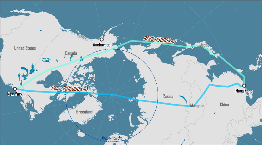
The older, more circuitous routings between Asia and North America, typified by R222, came at the cost of either a reduced payload or a refueling stop en route; commonly Anchorage. New polar routes, like Polar 2, were opened in 2001 and permitted fuller payloads, nonstop flights and shorter trips. The comparative difference between R222 and Polar 2 is about 2,000 km in favor of Polar 2, resulting in a reduced flight time of more than 2 hours, excluding the refueling stop.
Content from External Source
https://people.hofstra.edu/geotrans/eng/ch3en/conc3en/NYHKpolarroutes.html
 
It is easy to work out the shortest route between 2 cities. Either go to Google Earth and use the line measuring tool, or if you have a globe of the earth get a piece of string and use it to determine what path is the shortest.

It is counterintuitive because we don't realise that maps are a 2D representation of a 3D object.
 
When I first read the "no direct flights in the southern hemisphere" I thought I'd have a look and found 72 per week, flying between:

Johannesburg and Perth
Johannesburg and Sydney
Johannesburg and Sao Paolo
Santiago and Auckland
Santiago and Sydney
Perth and Mauritius
Auckland and Buenos Aires
 
When I first read the "no direct flights in the southern hemisphere" I thought I'd have a look and found 72 per week, flying between:

Johannesburg and Perth
Johannesburg and Sydney
Johannesburg and Sao Paolo
Santiago and Auckland
Santiago and Sydney
Perth and Mauritius
Auckland and Buenos Aires
Can you please list flight numbers (flight codes) for some of those flights, for future references.
 
Can you please list flight numbers (flight codes) for some of those flights, for future references.

Johannesburg - Perth - Johannesburg
South African Airways
SA280/281 (SAA280/281)
Departs Johannesburg every day at 21.10
Departs Perth every day at 23.50

Sydney - Johannesburg - Sydney
Qantas
QF63/64 (QFA63/64)
Departs Sydney every day at 10.50
Departs Johannesburg every day at 19.10 (usually)

Johannesburg - Sao Paolo - Johannesburg
South African Airways
SA222/223 (SAA222/223)
Departs Johannesburg every day at 11.10 (sometimes more than one flight per day, also departing 21.35)
Departs Sao Paolo every day at 18.00 (ditto, with extra flight departing 23.35)

Auckland - Santiago - Auckland
LATAM Airlines
LA800/801
Departs Auckland every day at 18.10
Departs Santiago every day at 00.55

Sydney - Santiago - Sydney
Qantas
QF27/28
Departs Sydney Sunday, Tuesday, Wednesday, Friday at 12.30
Departs Santiago Sunday, Tuesday, Wednesday, Friday at 14.30

Mauritius - Perth - Mauritius
Air Mauritius
MK440/441
Departs Mauritius Tuesday and Saturday at 22.40
Departs Perth Wednesday and Sunday at 13.05

Auckland - Buenos Aires - Auckland
Air New Zealand
NZ30/31
Departs Auckland Sunday, Tuesday, Friday at 20.05
Departs Buenos Aires Sunday, Tuesday, Friday at 23.59

>>>>

So I make that 74 flights every week, and more on occasion.

There may be differences in departure times on certain days, or other flights I'm not aware of. Corrections and additions welcome. :)
 

I tried watching this video....then I started skipping through it.
I like the first part how they try to explain why the petition only has 2k odd signatures. It reminded me of a video where two American TV preachers explain why they fly in private jets - because you never know when god is going to contact them etc. and being on a commercial flight would not be appropriate lol
Sorry if this is OT.

PS Their explanation of why they have only got 2k+ would tie in well with the thread titled 'The Majority Illusion'
 
Last edited:
Air New Zealand flies direct from Auckland to Bueno Aires each day over Antarctica, flight time is 11 hours 40 min..
Flight 30 i think it was..
Funny thing that they don't crash into "the barrier"..It would be kinda costly to send plane after plane and their passagers to crash inte "the barrier"..Not to even mention that 200 ppl or more would die each day..
I asked these guy for distances but between places cross oceans but the answer i get is that i'm a goverment spy that get payed to sabotage their treads in forums..They produce a map and can't tell distances on their own map..
[..]
 
Last edited by a moderator:
Johannesburg - Perth - Johannesburg
South African Airways
SA280/281 (SAA280/281)
Departs Johannesburg every day at 21.10
Departs Perth every day at 23.50

Sydney - Johannesburg - Sydney
Qantas
QF63/64 (QFA63/64)
Departs Sydney every day at 10.50
Departs Johannesburg every day at 19.10 (usually)

[...]
I’ve travelled several times between Perth and Johannesburg and Sydney and Johannesburg but didn’t ever realise I was unflattening the Earth.

Thanks. I feel validated. (Or rather, the unflat Earth is.)
 
Air New Zealand flies direct from Auckland to Bueno Aires each day over Antarctica, flight time is 11 hours 40 min..
Flight 30 i think it was..
Funny thing that they don't crash into "the barrier"..It would be kinda costly to send plane after plane and their passagers to crash inte "the barrier"..Not to even mention that 200 ppl or more would die each day..
I asked these guy for distances but between places cross oceans but the answer i get is that i'm a goverment spy that get payed to sabotage their treads in forums..They produce a map and can't tell distances on their own map..
[..]
That would be a cool flight to have a window seat!
 
Shot from the flight deck of the QF27 last December. Not my video.
At 32secs a black shape appears roughly in the centre of the shot, then tracks downwards and goes off screen, bottom centre at 35secs....

What is it?

what  is it.jpg
 
Last edited:
At 32secs a black shape appears roughly in the centre of the shot, then tracks downwards and goes off screen, bottom centre at 35secs....

What is it?

what  is it.jpg

Water. It looks like it's moving because the clouds above it are moving (and so are their shadows), compare it to the other very dark areas.
 
Water. It looks like it's moving because the clouds above it are moving (and so are their shadows), compare it to the other very dark areas.
Yup, your right, and there's a cloud right by it that looks like a shadow that and gives the impression of it standing out from the ground / ice.

but it had me baffled for a minute, In a fit of pareidolia my first thought was a nazi dinosaur ;)
 
Last edited:
Any idea where that is?

We have a limit of 72 degrees South for these flights, mainly for satellite communications reasons but also because terrain elevation is not accurately known, making it impossible to plan for a depressurisation event any further south.

So pick a point halfway between Sydney and Santiago at 72 degrees south and that's probably where it was.:)
 
I was having a discussion with someone who claimed that the LAN flights between Auckland and Santiago are "always cancelled two days before the flight".

But there are videos of people flying the route on YouTube, for instance:


and


There is one flight a day in each direction and the scheduled duration is 11 hours 20 minutes:

upload_2015-11-26_19-21-1.png

Looking at the most recent flight, on Nov 26:

Actual time of departure, 1921 NZDT (UTC +13) = 0621UTC.
Actual time of arrival, 1411 CLT (UTC -3) = 1711UTC.

Actual flight time was 10 hours 50 minutes.

The great circle distance is 6,005 miles, giving an average speed of 554mph. The cruising speed of a Dreamliner is 567mph.


Edit: note that this LAN flight (including the Sydney-Auckland leg) is the same one as QF321 in the screenshot in post 7 above: it's a codeshare.

If you actually follow open the video in YouTube you can see in the description that it was not a direct flight and took between 19 and 24 hours.
 
If you actually follow open the video in YouTube you can see in the description that it was not a direct flight and took between 19 and 24 hours.
What's your point? are you saying the continents move around all the time? or are you saying the "layover" is in a timewarp which causes people to lose track of time?

x.png
 
If you actually follow open the video in YouTube you can see in the description that it was not a direct flight and took between 19 and 24 hours.

They are direct flights and they don't take 19 and 24 hours. (You missed the "including layover").

In any case, I am an airline pilot who route structure includes flying the Sydney-Santiago-Sydney and the Sydney-Johannesburg-Sydney direct flights.

Happy to tell you all about them any time.
 
If you actually follow open the video in YouTube you can see in the description that it was not a direct flight and took between 19 and 24 hours.
As I said in my original post, it's the Santiago to Auckland segment that I was interested in. That is a direct flight, and it takes about 11 hours, which is far less than would be required on a flat Earth. The fact that the flight continues on from Auckland to Sydney is neither here nor there.
 
So after reading through all of this I was ready to scrap years of FE theory away. This flight was always the smoking gun. Well, then I came across this:

"In August 2005, Airservices Australia (Airservices) and the United States National Aeronautics and Space Administration (NASA) signed a Letter of Agreement (LoA) to undertake collaborative research on Air Traffic Management (ATM) decision-support automation, communication, navigation and surveillance. One project completed under the LoA focused on validating the Automatic Dependent Surveillance-Broadcast (ADS-B) In-Trail Procedure (ITP), a new airborne procedure that leverages the benefits of ADS-B to provide a means for pilots to make more informed requests of Air Traffic Service Providers (ATSPs) and enable altitude changes that previously would not have been approvable. Intended for use in non-RADAR (radio detection and ranging) airspace that employs procedural separation, the ITP uses airborne ADS-B data, onboard tools, and a new separation standard based on these data and tools to provide ADS-B-equipped aircraft with better access to preferred flight levels in oceanic and other remote airspace."

NASA cant be trusted.
 
NASA cant be trusted
Could you explain what you mean by this, and what you think the LoA means for the flight we are talking about? Metabunk deals with claims of evidence, not vague innuendos.

How does this have any bearing on the length of the flight between Australia and South America?
 
Back
Top