Debunked: this photo shows a Ukraine Mig-29 shot down MH17

Well, though Severed's post (#39) is kind of a word salad of potentially ominous sounding stuff...
there's definitely some truth in there--somewhere--but the reality is not particularly mysterious or scary:

The CIA has a pretty cool--out in the open--tech venture called "In-Q-Tel." https://www.iqt.org

In-Q-Tel has helped develop tech projects like Google Earth & Recorded Future https://www.recordedfuture.com
advance technology in ways that the CIA believes will help them do their job.

Surprisingly transparent for the cloak & dagger realm, and the improved technology trickles down to us peons.
 
I don't agree that it is improbable that we were keeping close watch on Ukraine.
Which I never said so there's no need to disagree on that. I was countering your 'it is logical to assume the attack was caught on camera by the US because of $100 billion spent on intelligence' - there is small chance but it doesn't mean it should be assumed.
 
First claim: what are the chances that a spy satellite would just happen to be in exactly the right position at exactly the right moment to take a photo of such an event? Pretty astronomically tiny! However large the US government spying budget is, they don't have a live view of the planet that they can just zoom in on any spot at any time. Spy satellites don't work like that.

As for the claim of altered images at Google. Well there is no evidence that it has been altered. And Google doesn't generate its own satellite imagery, of course. All the satellite images on Google Earth are from commercial image providers, and can be checked with the providers, so if anyone is doing the altering, it wouldn't be Google.

And there are plenty of other reasons it is fake. For one, the size of the plane is ridiculously huge. If you measure the plane on the image, then plug in the altitude of the satellite that took the image and the altitude of the plane, the airliner would have to be about two and a half miles long!
Correct, most of the imagery for Google earth comes from digital globe satellites like quick bird. So it's all readily available from them. Or at least with the digital globe account any ways.
 
Please provide evidence of this claim. It is very interesting (if true).
Well keyhole is part of Google Earth, because it was originally called Keyhole Earth View or something like that before it was Google Earth. Thats why Google Earth files are called KML/KMZ files (stands for keyhole markup language) the type of source code they used to program the original earth view. So it wouldn't surprise me if it was originally a CIA program or something like that.
 
Well keyhole is part of Google Earth, because it was originally called Keyhole Earth View or something like that before it was Google Earth. Thats why Google Earth files are called KML/KMZ files (stands for keyhole markup language) the type of source code they used to program the original earth view. So it wouldn't surprise me if it was originally a CIA program or something like that.

The Keyhole that Google purchased in 2004 was founded in 2001. According to the Wikipedia entry on Keyhole, Inc., the name was chosen, in part, in homage to the KH ('Keyhole") series of reconnaissance satellites. However, In-Q-Tel *was* an early investor in Keyhole.
 
Seems to be debunked. A couple of thoughts, the US spends almost a 100 billion dollars on intelligence, isn't it logical that unless they're only spying on the western world, that they would have genuine images of the shootdown? Also how reliable is Google Earth? This image has been out there for a while and the head of Google is very close to the US government, I've heard. Could the images simply be altered at google?
so let me get this straight. You are suggesting that instead of scenario a)
Someone faked this by getting a picture from Google Earth (clouds match exactly)and photoshopped planes into it, (which appear at least to be a 767 and a Su27 and NOT a 777 and a Mig 29) and faking in a picture that does not even match the profile in the video and letter (at the point the su27 is firing the missile, the cockpit appears to be completely intact AND this is NOT a classic fighter attack scenario as for a sure shot,especially if no-one is firing back, you would prefer to be actually behind and slightly above the target.

You seriously think we should entertain Scenario B)
it's a REAL satellite image (that just happens to have been in exactly the right place at the right time, bearing in mind spy satellites move with respect to the Earth and their position changes all the time). showing the shoot-down of the plane, but military analysts mis-identified the type of aircraft doing the shooting, AND despite the cockpit being shot off it looks intact from above AND the pilot picked a pretty poor angle to take the shot from.
THEN, just so they could discredit this information that was obtained from wherever, the CIA sent the picture to Google,presumably after editing the planes out of the picture, asking/telling them to replace their previous image with this one, keeping it backdated to August 2012.

Really?
 
. After all, Google Earth was a program named Keyhole until the CIA sold it to them
That's not right. Keyhole was a private firm, although it did have funding from the CIA.

Initially launched as a spin-off of Intrinsic Graphics, first round funding came from a Sony venture capital fund and others, additional capital came from an NVIDIAbundling deal, from the CIA's venture capital arm In-Q-Tel,[1] with the majority of In-Q-Tel' funds coming from theNational Geospatial-Intelligence Agency,[2] and from angel investor Brian McClendon[citation needed] (who later came on as a board member and VP).
Content from External Source
http://en.m.wikipedia.org/wiki/Keyhole,_Inc
 
I'm interested in the process that determines how the scale is wrong, ie, how high would that fighter have to be flying to appear that size? Or conversely if it were flying at 30,000 feet what would its size be?
If there is math involved can someone break it down for me?
 
I'm interested in the process that determines how the scale is wrong, ie, how high would that fighter have to be flying to appear that size? Or conversely if it were flying at 30,000 feet what would its size be?
If there is math involved can someone break it down for me?

This page gives a brief explanation:

http://www.whathappenedtoflightmh17.com/proof-the-russian-tv-satellite-photo-of-mh17-is-fake/


The plane appears to be 4.5km long as measured between markers on the ground: I have verified this here:

upload_2014-11-16_20-32-15.png


So to appear this big, it would have to be very close to the altitude of the camera - in this case a mere 145 metres below it.

The maths is just based on "similar triangles" - the ratio of height to base is the same in the small triangle at the top (with the plane as the base) as it is in the whole triangle (with the ground as the base).

upload_2014-11-16_20-13-42.png

So you can solve for the unknown (the height of the satellite above the aircraft, which I will call X) as follows:

(10000+X)/4500 = X/64

multiply both sides by 64

(10000+X)/(4500/64) = X

rearrange:

X = (X+10000)/70.3

70.3X = X+10000

69.3X = 10000

X = 144.

Whereas a satellite would typically be at a height of about 450km (for QuickBird satellites), which makes the distance between the plane and the ground fairly negligible. So from a satellite at a genuine altitude, the plane should only be concealing a distance very slightly longer than its actual length on the ground.

So applying the same maths to the real altitude of the plane, how big should it appear to be "on the ground"? I'll call that distance Y

Height of satellite above ground = 450000m
Height of satellite above plane = 440000m

So:

440000/64 = 450000/Y

Y = 64 x (450000/440000)

Y = 65.5 metres.

In other words, becuase the satellite is so far away, the plane should only appear a factor of 450/440, or about 2.3%, longer than its real length.
 
Last edited:
Hi! New member here.
Thanks for the great site.
I recently started a blog at
https://auitto.wordpress.com/

One of my very first articles was this story about the Russian claims for "Satellite image" and the following rebuttals from Metabunk, Bellincat and whathappenedtoflightmh17.

I was sent today some pics that the sender claims to prove that there would be a mismatch between the alleged satellite image and the picture that has been used to refute it.

Please see this article:

https://auitto.wordpress.com/2014/1...claims-to-have-a-leaked-satellite-image-mh17/

and there the section "Alleged problems with the rebuttals".

As I have no experience in image manipulation and such related arts, I'd be grateful if you guys would take a look at those images and give me your comments if this concern is legit at all. Or is there an obvious explanation?

I wonder how much this matters now that there is so many things but still... If you know the answer to this one, please tell me so that I'll become wiser. :)

Thank you for you time.

Antti
 
Hi!

Here are the images I got today:


Then this comparison


And the claim that came with them was that the plane used in the refuting material and the plane in the original "Satellite image" would not match and some image manipulation would have been used to make them match in the rebuttals.

Thanks!

Antti
 
I don't think it's the same plane. But there are literally hundred of images to choose from in Google Earth.

It's entirely besides the point which plane it is, as the image is proven fake by the clouds (from Google), and the size of the plane.
 
It's entirely besides the point which plane it is, as the image is proven fake by the clouds (from Google), and the size of the plane.

Exactly. If this was a genuine satellite image from, say, a Quickbird (DigitalGlobe) sat, then the plane would only appear about 1.5% as long as it does in this picture.

Does Google Earth give the source of the original picture? I don't have it installed on this machine.
 
Pete Tar, I understand that the main point of the complaint is that the length of the planes is different. In the switching image the tails of the plane are aligned but the noses then do not match.

Mick West, I agree with you on both points. However, when I got these pictures, it made me think that it is a shame if someone had used photoshop magic to make them "match". That seems a bit redundant.

Thank you for your answers!
As I mentioned, look at the images in post #19, they are not the same.
 
auitto,

Here is the original image from Дюк on this Russian forum, on Oktober 15 :
http://obkon.ucoz.com/forum/59-1403-1#6869

This image made to via George Belt, and was signed off by the Union of Russian Engineers (who could not find anything wrong with it) to 1tv.ru (Russian state TV network).

Here is a cut-out from that image of the plane :

9771894-1.jpg

and here is an image of the Boeing 767-200 original :

767200-fa129119.jpg
Now if you look closely, you will see that in order to match the outline of these two images, you need to BOTH change the angle AND the length of the plane (in Photoshop or so).

If you do that properly, you will get the animated gif match as TEEJ showed in post #19.

It seems that your animated gif you ONLY adjusted the angle, but not the length.

Either way, I wonder if it is useful here on Metabunk to now start to reverse engineer the actions of not just the original guy who faked the image, but also some new fake images by yet some anonymous editor ; images that are not even aligned by length...
 
Last edited:
It seems to me that the most obvious problem with this supposedly "satellite" picture as presented by Russian state TV channel 1 is that the plane appears to be 4 km long !

And that neither tv1.ru editoral staff noticed that blatently obvious problem with this image,
nor the "experts" that tv1.ru pulled in to give their story any form of credibility, most notably :

George Bilt (an supposedly MIT graduate, and supposedly an aviation expert with 26 years of experience),

and even the Union of Russian Engineers, whos first VP declared :
"We can assume that the photograph was taken by an American or British satellite,"
and even more embarrassing :
"we have studied the photograph in detail and found nothing suggesting that it is fake."
http://www.bbc.com/news/world-europe-30064374

This picture is not just proven to be a crude fake, but since it is shown on Russian TV, while the "experts" of the Union of Russian Engineers can't even find anything wrong with it, and even use it to allege that Ukraine shot down MH17, it is also a despicable insult.

An insult to reason, an insult to honesty and an insult to the 298 people that perished in this catastrophy.
 
On the Bellingcat link there is a reply from someone claiming to have contacted George A Bilt.


Void2002 - November 17th, 2014
I contacted mr. George A Bilt and confronted him with this story and here is his answer:

“I think owe you an explanation or possibly a disclaimer if you will.
Here comes my side of the story. First, explaining my motivation.
The war in Eastern Ukraine is a huge tragedy but as many people I was totally shocked by MH17 crash. I do believe.that this is our Christian and civic duty to fully pursue and embrace the truth – for those 300 innocent victims – but ultimately for our own moral and civilizational survival. Because this is a very bad world indeed where they murder 300 innocent people in a broad daylight and go unpunished. This is not about Ukraine or Russia, or the rebels. This goes beyond and above of any petty geopolitical or political games or even (!) wars. This is the ultimate choice between the good and the evil. This is about our own self-preservation from the moral and possibly physical Armageddon. Truth is the only way of our survival.
Second, trying to understand what happened with MH17 and trying to help.

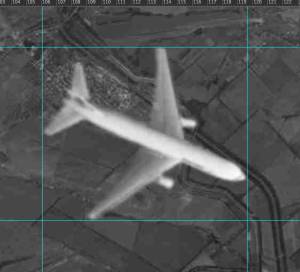
Since July 17 I have been collecting various MH17 related and investigation pertinent materials, links and information (in various languages). I passed it first of all to the Dutch Safety Board, including this specific satellite (?) photo which unexpectedly hit the news yesterday and its source reference (the original forum message and link dated October 15, 2014). Recently I also came across the MH17 crash analysis prepared by RUE (Russian Union of Engineers / Mr. Andrievsky), conveniently posted both in German and English. Their analysis seemed to me as one of the more systematic and quality attempts available by now to investigate this crash. I also believe that MH17 was more probably shot down by a jet fighter than any anti aircraft missile system.

I am not taking any sides in this conflict. I have no idea why and who did it. Suffice it to say that any war is a source of immense chaos and confusion. Quite often people do lose control and minds at war. Any men with arms and sense of power could present risks, violence and danger. This is not ethnic – this is human. Anything could have happened. There is no way to know.

Third, reaching out to RUE / Mr. Andrievsky. Having read their analysis, I contacted RUE / Mr. Andrievsky via email. Giving my version of the possible or probable jet fighter attack and sending them the (possible) satellite photo in question (again found via social networks however reliable) as a potential hint or tips for their further investigation, if any with the following source reference (sent to them via a followup email / see below verbatim):

QUOTE

The source of the below attached satellite photo is http://obkon.ucoz.com/forum/59-1403-1

As per messages 14 through 17. It says in essence there (in Russian) that this photo was received from the Russian Wikileaks / specific source not indicated and as per the UTC time format it could have been made by some American (read Western, commercial, non Russian etc) or intelligence satellite. It was definitely not made by any Russian satellite. Possibly more information could be obtained from the person who posted this file on the forum.

UNQUOTE

I had no knowledge or means of proving and researching if this was an authentic satellite photo or not (it was clearly available online since mid October – not really such a new discovery too). RUE seemed to possess such research means and resources. I do not know if this was my mistake in evaluation.

Fourth, an unexpected outcome.
What I definitely completely did not expect to see is both this email (sent in implicit confidence) and (unconfirmed!) satellite photo from social networks suddenly popping up in mass media. Without the above properly provided source reference, without my permission and with a statement that this photo was basically done or found by me. Even though This is either a clear misrepresentation and / or cultural misunderstanding. I never knew and never stated if this was an authentic or unique photo.

I again believe based on the available information that MH17 was more probably shot down by a jet fighter. Do I know it? No. Could I be wrong? Yes (now more than ever!). Am I an investigation professional (quite unique skills)? Again no. As a minimum this is an option which needs to be fully exhausted and studied.
Indeed, it appears that the MH17 investigation is going slow, tight and hard due to
many reasons. The official details are quite scanty so far too. This is frustrating for many more people. That is why I sincerely tried to do something about it, to possibly help moving it.

Hoping to come closer to finding out the truth about this horrible tragedy.
I am quite unhappy that my bona fide informal attempt possibly became a source of yet another battle in a media war. Possibly via a misunderstanding. This was definitely not my intention. I am also not looking for a cheap fame. This tragedy is simply too awful to gain from it.

I am sorry for all those people I might have indirectly and unintentionally misled or disappointed by this unexpected mess in anyway. My takeaway lesson – this is more complex and confusing than it seems. This is important to be discreet, humble and patient. Let us all calm down. I do believe that the Dutch Safety Board will find the truth as 200 of their compatriots were killed in this tragedy.
Personally and professionally, I will not continue with this amateurish investigation effort due to the rather insane highly confrontational situation prone to escalation and with the elements of media war.

You are welcome to publish this.

Best Regards,”

Content from External Source
https://www.bellingcat.com/news/201...on-shares-fake-images-of-mh17-being-attacked/
 
I think a quite obvious clue for a fake is overlooked. How did the clouds that covered the whole area 17th July magically disappear from the satellite shot?

Page 17 of the preliminary report of the Dutch Safety Board:

Analyses of ground observations show that in the vicinity of the occurence mutiple thundershowers were reported. Just to the west- south-west of the last known position of the aircraft, culumonimbus (CB) clouds were reaching up to FL350 were present at the time
Content from External Source
http://www.onderzoeksraad.nl/upload...3acad0ceprem-rapport-mh-17-en-interactief.pdf


In addition, just one of the many available videos from the crash site just after impact. Take a look at the sky:

 
Last edited:
The claims of Ukrainian aircraft involved in the MH17 shoot down just goes on and on. Now people are claiming that they can name the pilot of the Su-25! December has seen an upsurge in Russian media reporting. Earlier this month they were showing eye witness interviews who claimed to have seen the fighter fire on the Boeing 777.

Note that the reporter is still pushing "bullet holes"

See from 2:14

Local "It flew towards the passenger plane and when the two were at the same
level ... it shot onto the engine of the other aircraft. There was immediately a flash.

Reporter "So you saw with you own eyes that the other fired at the plane?"

Local . "Yes"

Another local follows this interview. She claims that the fighter was firing flares.


The most recent claim of naming the pilot of the Su-25!


Ukrainian Air Force Captain VLADISLAV VOLOSHIN Accused of Shooting Down Malaysian Boeing MH17

"In the afternoon [July 17], about an hour before the shoot down of the Malaysian Boeing, three Su-25 took off on a mission. The precise time I don't recall. One of the aircrafts was equipped with a missiles of class air-to-air. The planes were Su-25's " said the witness, whose name has been withheld by the publication.

"Only one of the aircrafts made it back to the base - the one that had initially been armed with the air-to-air missile, which was now missing. The other two planes, I learned, had apparently been shot down."

The witness is then asked whether he recognized and could name the pilot.
"It was Capt. Voloshin. Vladislav, I think, is his first name. He seemed very scared, frightened and appeared to be acting inadequately. With the other two planes getting shot down, he might've mistaken the Boeing for an attacking combat aircraft."

According to the witness - immediately upon exiting the cabin, Voloshin was heard saying "Not the right plane." Later in the same day, on the issue of the aircraft, he replied, "Wrong place, wrong time".
The witness also said that the missiles installed on the Su-25 had previously been written off, but a week before the disaster, their service was extended to "urgently".

Content from External Source
http://www.kp.ru/daily/26323.5/3204312/
 
Last edited:
The sat pic wasn't published yestereday, it's from Nov 15.
Make sure you're not confusing the current date which some sites run as a banner with the publishing date.
 
You write: Yesterday three different Version were published through Russia Media.

I thought you were saying that the sat pic hoax was put out again yesterday.
 
Back
Top