Spectrar Ghost
Senior Member
What does the 0.159 refer to?
Based on context I'd presume it's a reduction in surface temperature of 0.159C.
What does the 0.159 refer to?
A 1905 book on clouds has been uploaded to Project Gutenberg, the scans of the illustrations are not perfect, but the show quite clearly that clouds back then look like clouds now.
Cloud Studies by Arthur W. Clayden (1905)
Result: Every single book on clouds that I could find for the last 70 years says that contrails can persist for hours.
can persist for hours - --
I'm not sure that a few hours, but I'm sure that I watched 30-40 minutes ..
everything depends on the weather and the airplane.
There are many things to consider when talking about contrail formation. Just off the top of my head, and not in any particular order:One problem I have in telling people that contrails can actually persist, and can even spread out to cover the sky, is that people tend to be suspicious of random people on the internet. So I decided to simply let 70 years of books on clouds speak for themselves.
It's interesting because even back then, in the very first few times that planes had flown at that altitude, the causes of contrail cloud formation were broadly understood.External Quote:
Cloud Formation by Supercharged Plane
An altitude flight was made in the morning at McCook Field, recently, by Lieut. J. A. Macready in a LePere with supercharged Liberty. When the airplane reached a height of 26—27,000 feet at 11.50 a. m., a long feathery white streamer was observed forming behind a rapidly moving dark speck. The cloud was of the cirrus variety, well defined at its edges and apparently ten to fifteen times the width of the plane. The sky behind the first portion was clear blue with no other clouds in the near neighborhood. The first streamer seemed perhaps two miles long. Then a gap of one-quarter mile. The second streamer formed with a background of light cirrus cloud and after two or three miles the plane seemed to go into the cirrus background for the streamer formation ceased while an apparent path of blue continued beyond for a way in the cirrus cloud. The whole streamer may have been three miles long. After twenty minutes the streamer had drifted and spread until it merged indistinguishably with the other cirrus clouds visible. The weather conditions at the time were generally very clear, warm, with perhaps 0.1 of the sky in cirrus clouds.
The observer reported as having observed nothing unusual; occasionally the motor would give a burst of black exhaust gas. The pilot thought he remembered having passed through a stratum that felt damp. Clouds at this altitude are necessarily ice crystals, or needles, and it is difficult to determine the cause of the cloud formation under consideration. Possible contributing causes are: Water in exhaust; dust and carbon particles in exhaust serving as cloud nuclei; convective currents due to disturbance caused by passage of plane. Conditions of humidity were undoubtedly ideal for the formation of cloud at that altitude.
This has been posted before, but the version I saw before was the reprint without the last paragraph
One problem I have in telling people that contrails can actually persist, and can even spread out to cover the sky, is that people tend to be suspicious of random people on the internet. So I decided to simply let 70 years of books on clouds speak for themselves.
Result: Every single book on clouds that I could find for the last 70 years says that contrails can persist for hours.
The problem is that we're seeing persistent contrails in the dead heat of summer which is nowhere near -40 C.
This was the temperature around 33.000ft in early July 2019The problem is that we're seeing persistent contrails in the dead heat of summer which is nowhere near -40 C.
Many passenger airliners have information displays on the TV screens on board which show the current altitude, speed, location and often the external air temperature. Have a look next time you are on a plane. No matter how hot it is on the ground, chances are it will be somewhere in the -40C range or below when you are at cruising altitude.The problem is that we're seeing persistent contrails in the dead heat of summer which is nowhere near -40 C.
What that's saying is that in the course of that particular study, that the areas around a tropical storm were producing more ice at altitude than regular thunderstorms, despite the temperature at altitude being the same. The higher water and surface temperatures under a tropical storm are lofting more moisture up to the level where ice can form, because there's a higher rate of evaporation.External Quote:Flights 12 and 13 were the only flights to be performed in the same long-lasting quasi-stationary system, a tropical storm, and for these two flights, the concentrations of large ice particles were found to be higher than in all other clouds sampled at the same temperature level. MMDs mostly exceed 500 μm and even reached 2 mm. Moreover, in these flights MMD tended to increase with increasing TWC, the opposite trend found for the classical shorter-lived oceanic MCS.

From 1973 to 1993 I worked at a company that was not far from a major airport (Cleveland-Hopkins). Views like this were often visible throughout these years, depending on the weather conditions.
I've found people tend to think "chemtrails" started when the first noticed some persistent contrails and heard about the theory. A classic example being J. Marvin Herndon, who is convinced they started ove San Diego in 2014. Yet there were many pages from a local Chemtrail group that proved otherwise.As new people discover the chemtrail theory all the time, so the date when it supposedly started shifts until it becomes more and more recent. There are lots of claims that it started around 2019 – or even as recently as 2021 (when air traffic started returning to normal after the pandemic).
So here we have the most well credentialed scientist ever to back the chemtrail movement, someone with a Ph.D. and several published papers to his name, claiming that "chemtrails" in San Diego only started in 2014, and that before that you were luck to see one contrail a day, in the distance, maybe.
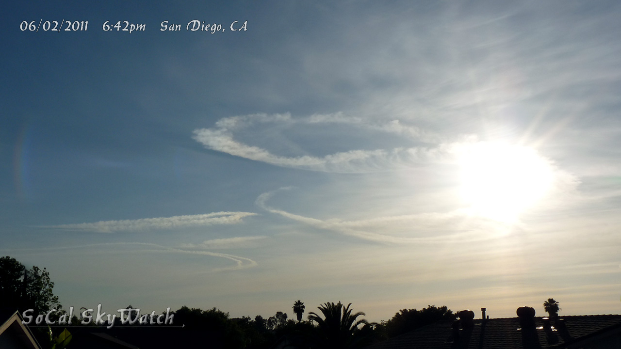
The problem with this, and the reason it disproves the more general "the skies don't look like I remember" claim of evidence, is that he is demonstrably and inarguably mistaken. Many people, including many chemtrail activists have seen persistent trails in San Diego prior to 2014. And there's documented evidence, from chemtrail activists that far more than one trail has been observed over San Diego, on many days of the year, dating back decades.
For example, take the chemtrail site "SoCal Skywatch", based in San Diego, has many images of multiple spreading contrails, very like the ones that Herndon first noticed in 2014, dating back several years to when the site was set up in 2010.
https://www.google.com/search?es_sm=119&biw=1066&bih=803&tbs=cdr:1,cd_max:2013&tbm=isch&sa=1&q=san+diego+contrails+site:socalskywatch.wordpress.com&oq=san+diego+contrails+site:socalskywatch.wordpress.com

