Debunked: MH17 - 10 Previous Flightpaths Different From 17-7

Ezswo

New Member
A "rumor" that keeps popping up on various websites is that the flightpath of MH17 on the day of the crash is significantly different than the previous 10 flightpaths of MH17. The image seems to originate from a Twitterer called Vagelis Karmiros who placed the following tweet on the 17th of July:


See for example the following websites:
http://www.zerohedge.com/news/2014-07-17/was-flight-mh-17-diverted-over-restricted-airspace
http://www.wanttoknow.nl/politiek/o...eersleider-en-kiev-vluchtdata/comment-page-1/ (dutch article, scroll down for the same, modified image).

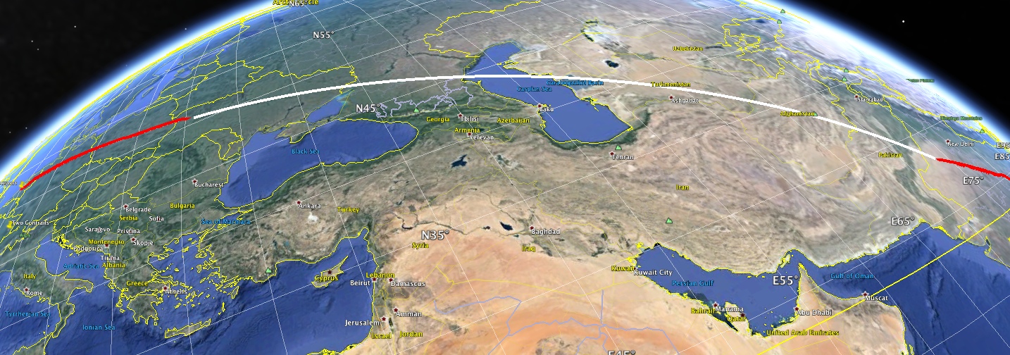
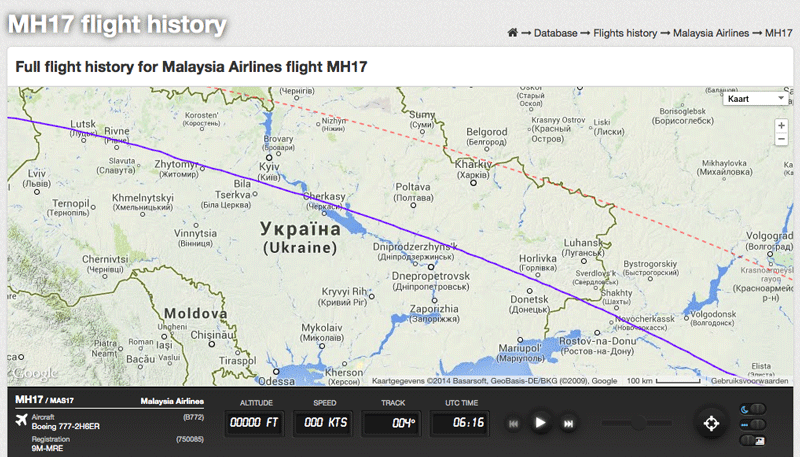
This "fact" is then used to create suspicion on why this particular MH17-flight was diverted over restricted air space and into the area between Donetsk and Luhansk. Whereas the previous flights allegedly flew far south from Donetsk, away from this area.

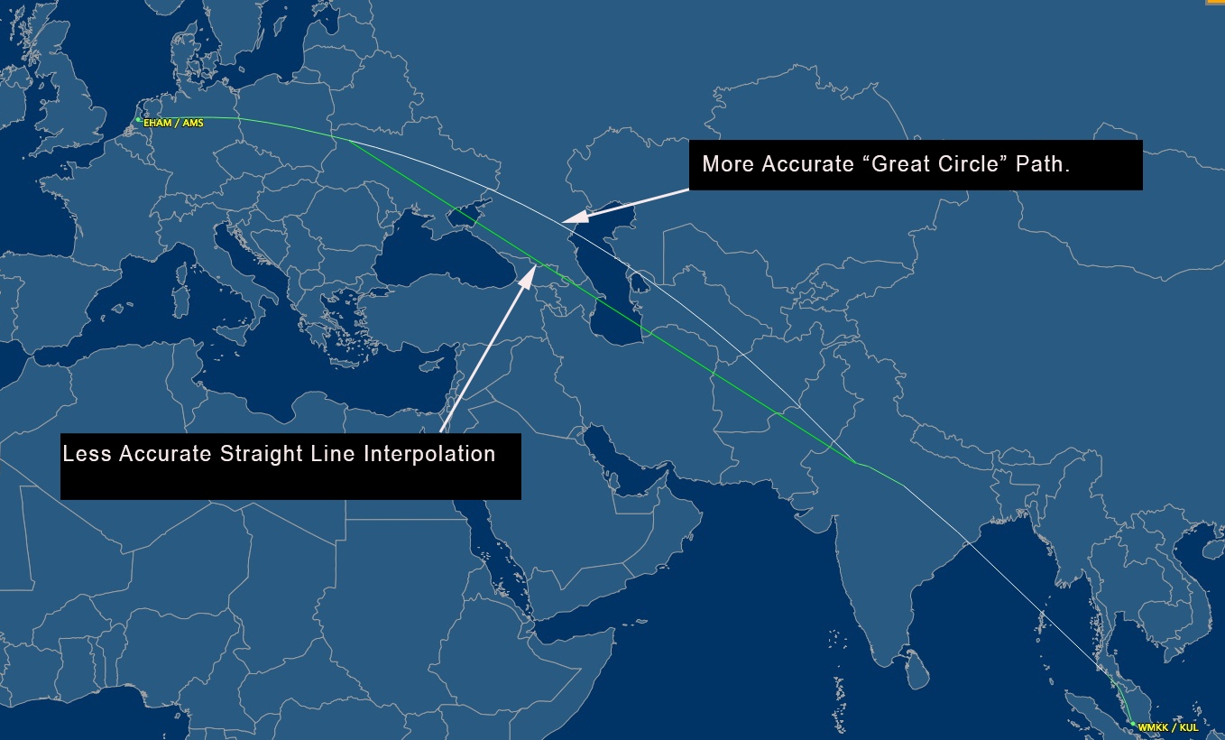
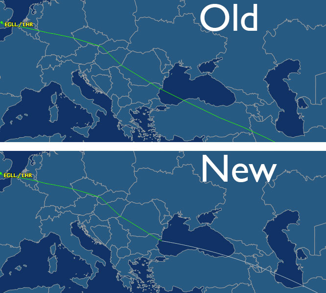
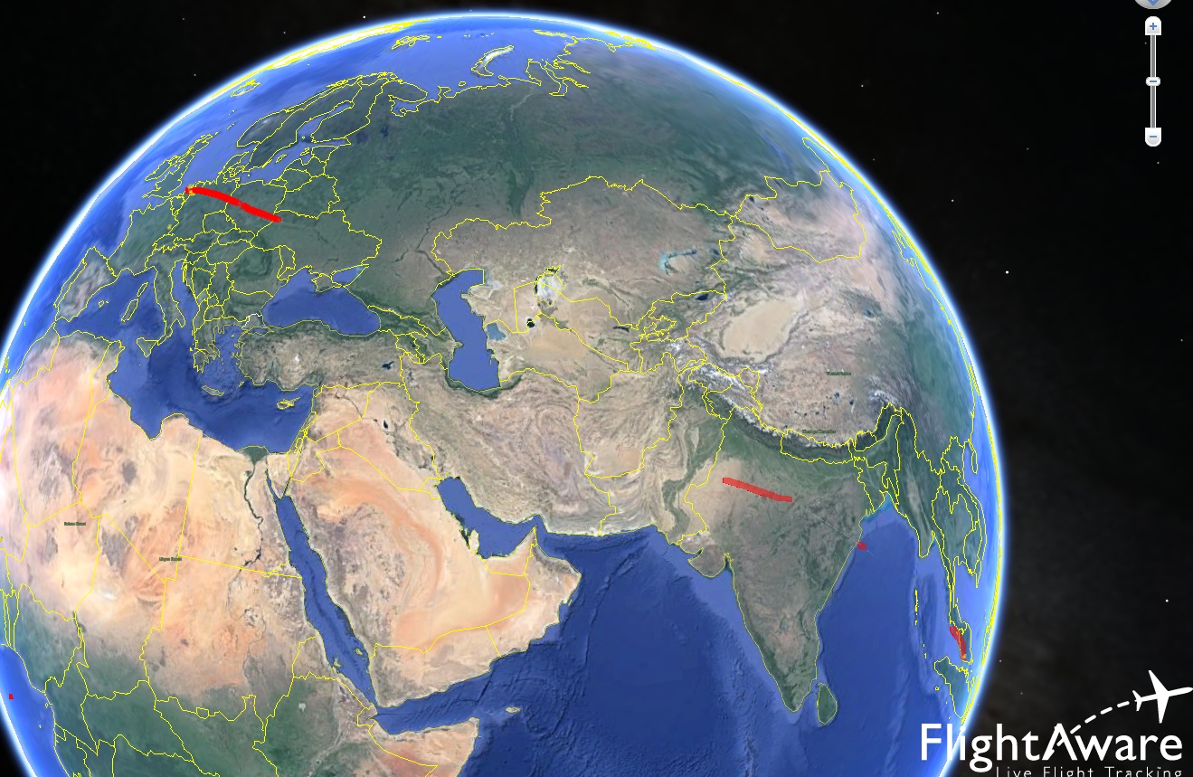
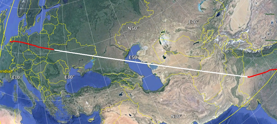
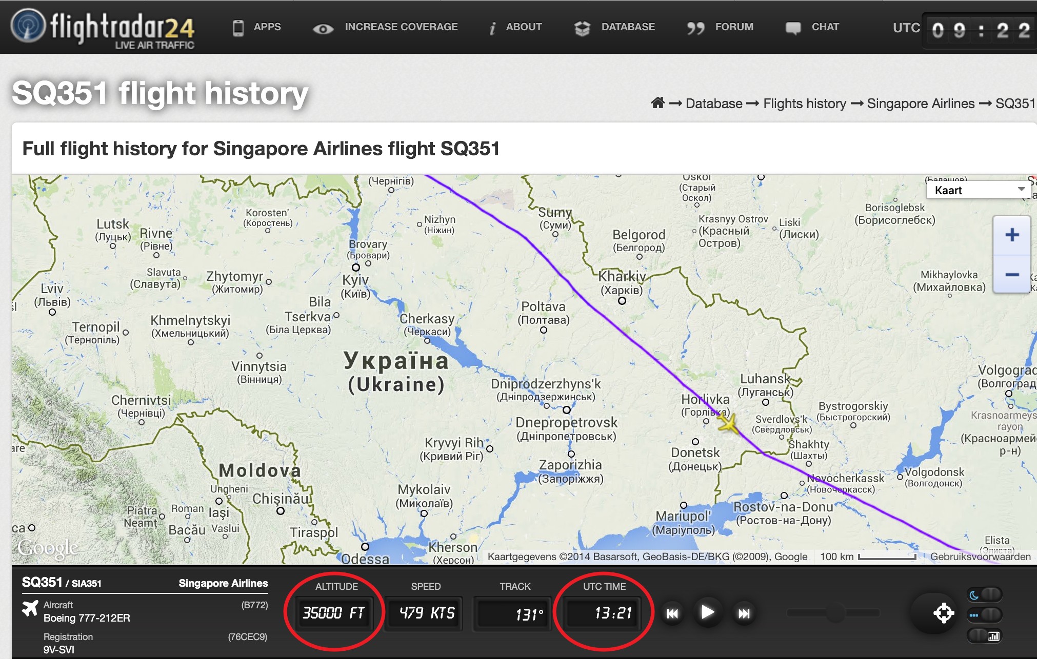
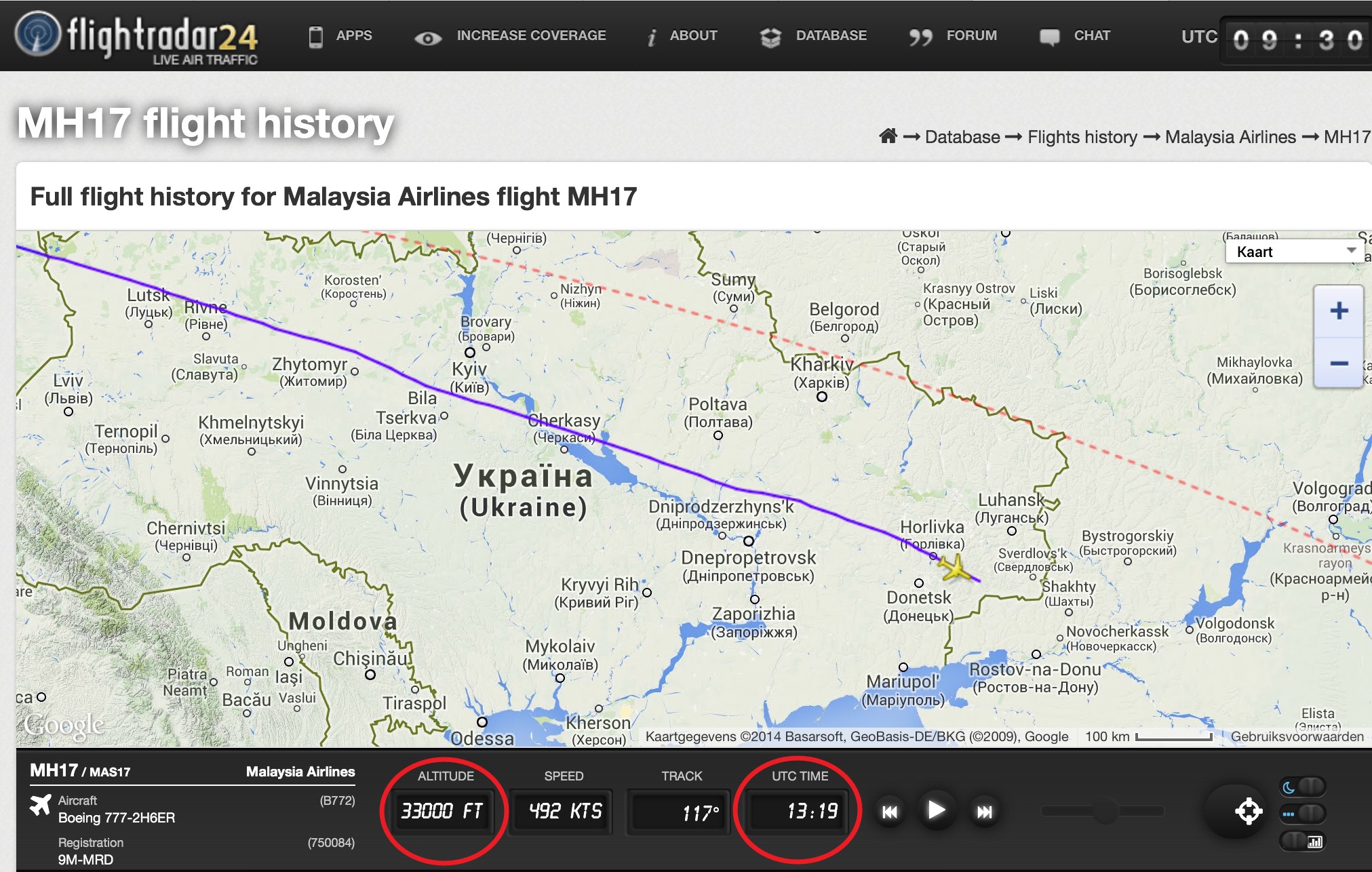
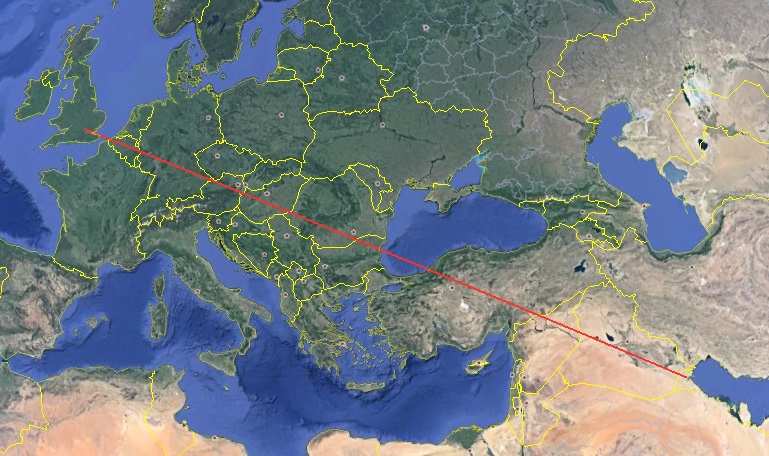
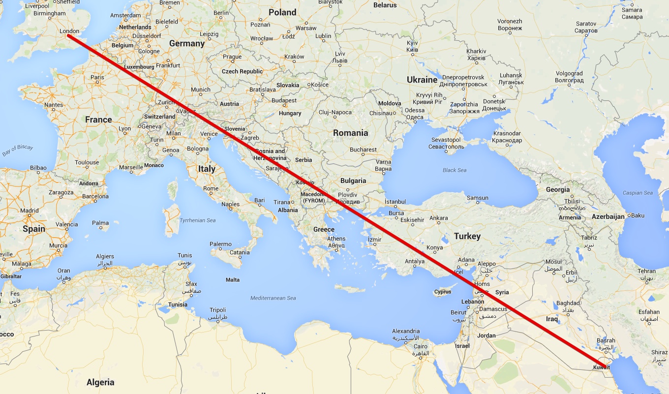
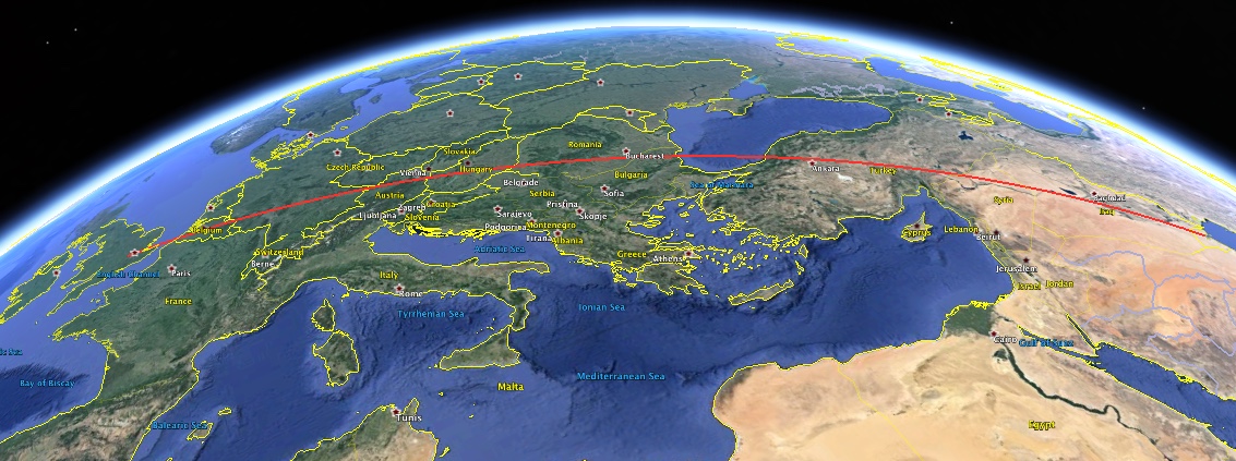
When we check the flight history database of flightradar24.com, his claim doesn't stand up to scrutiny. I made the following animation of the flightpaths of MH17 from 8 July - 17 July and as you can see the flightpath (with one exception) always crossed the area between Donetsk and Luhansk. This area is on the right side of the image close to the border of Ukraine.


Can we call this debunked of am I missing something?
 
The reason this happened is because people were combining the FlightRadar24 data, which was accurate up to the crash area, with the FlightAware route history, which was only estimate in that area.

Flightaware does not have coverage in that area. It stops shortly after entering the Ukraine, and only resumes over India. At the time the claims were made, FA would simply link up the segments with a straight line on the map. This leads to errors, as the plane flies a route more like a great circle, and it does not account for any changes in course between the two points.


So the original claims were in good faith, just wrong.

This was explained on the FA site:
http://flightaware.com/news/article/Improvements-to-FlightAware-Maps--Understanding-Map-Behavior/196


  • In areas of limited coverage (for example, over an ocean or a rural part of the world), it is possible for FlightAware to not receive position updates from the airplane for an extended period. When tracking an airborne flight that has left our coverage area, you'll notice that the airplane icon changes from green to hollow white, a range ring is drawn around the airplane, and the word "ESTIMATED" is written next to the airplane icon. Once we receive the next position update, we suppress the estimated positions from the map and draw a line from the last known position to the next position. We've made two changes to improve how we handle this situation:
    1. When there's a coverage gap, we now draw the track gap in white, not green, so it's clear which part was out of range.
    2. When we draw the coverage gap, we no longer draw a flat, straight line on the image; we now project the great circle route that takes into account the curvature of the earth and the route an airplane will fly.

    These changes will make it much easier to understand FlightAware maps and the changes are retroactive, so flight maps that you've looked at in the past might appear slightly different, although the underlying data hasn't changed. You can always click "track log & graph" on any flight to see the raw data, or click the Google Earth icon to export the positions to a KML file.

  • Of course, it's still important to understand that the white line reflects a lack of data and you can't draw any conclusions from it, since it may suggest that, for example, a flight flew through a country that it really deviated around. We are constantly working to improve our coverage and more data sources are added almost daily.
Content from External Source


And if you look at the flights in Google Earth, you will see they don't even have any interpolated points in the missing segments.


And here is what is meant by a "great circle". If you join two points on a globe then the shortest distance between them is always part of a circle that goes all the away around the world. It looks like a straight line viewed from edge on:


But it's actually a curve, as it's on the surface of a sphere:
 
Last edited:
Thanks Mick for the further clarification on the workings of Flightaware, I wasn't aware of that (pun intended).

There's actually another claim that's made about the flightpath of MH17 on July 17th in comparison to other flightpaths of earlier flights. And that has to do with altitude. There's much rumor in the Netherlands about an “extraordinary” order that was given to MH17 to lower his altitude to 33.000ft instead of the "normal" 35.000ft. In the Netherlands (where I live) a politician asked questions about this in our parlement, which questions were answered by our minister of foreign state affairs, Frans Timmermans. Timmermans stated the following [translated by me, Dutch original here]:

"The only deviation of the flightpath in comparison to the flightplan, is the altitude above the eastern part of Ukraine (in the Dnepropetrovsk Flight Information Region). According to the flightplan flight MH17 should have flown at an altitude of 11km (flight level 350), but the Ukrainian air-traffic control allocated an altitude of 10km (flight level 330). This deviation in altitude had an operational background: this way there was enough distance secured between flight MH17 and another plane that already flown at an altitude of 11km.”

Naturally this explanation of our minister of foreign affairs was discarded as a lie as part of this supposed MH17 false flag operation. As you can see from the two screenshots below this notion van easily be debunked. Flight SQ351 (Singapore Airlines from Copenhagen to Singapore) was almost at the same time (13:21 UTC) at the same spot as flight MH17 (13:19 UTC). Flight SQ351 flew at an altitude of 35.000ft, so there’s nothing abnormal about an flight altitude of 33.000ft of flight MH17.

So yes, it was a deviation from the flightplan, but with proper reason I would say.


Last edited:
There's much rumor in the Netherlands about an “extraordinary” order that was given to MH17 to lower his altitude to 33.000ft instead of the "normal" 35.000ft.

The minister was correct. European airspace is complex with many intersecting air-routes. It is not unusual to be given an instruction to climb or descend away from an aircrafts optimum flight level in order to accommodate traffic separation.
 
Thanks Mick. Exellent post.
(I've had a lot of discussion about it)

It's also interesting to look at the flightpaths of MH16 in that period. Which were the same planes, but flying in opposit direction (on their way to Amsterdam from Kuala Lumpur)
The same aircraft (9M-MRD wich was shot down) flew earlier that day (july 17 about 01:28 UTC) also over seperatist-controled area. It passed some kilometers north of the spot where it went down 12 hours later.
 
And on a related note, this video shows the air traffic in the region for 90 minutes before the crash, showin it was not at all odd for planes to be flying in the area.
 
Thanks Mick for the further clarification on the workings of Flightaware, I wasn't aware of that (pun intended).

There's actually another claim that's made about the flightpath of MH17 on July 17th in comparison to other flightpaths of earlier flights. And that has to do with altitude. There's much rumor in the Netherlands about an “extraordinary” order that was given to MH17 to lower his altitude to 33.000ft instead of the "normal" 35.000ft. In the Netherlands (where I live) a politician asked questions about this in our parlement, which questions were answered by our minister of foreign state affairs, Frans Timmermans. Timmermans stated the following [translated by me, Dutch original here]:

"The only deviation of the flightpath in comparison to the flightplan, is the altitude above the eastern part of Ukraine (in the Dnepropetrovsk Flight Information Region). According to the flightplan flight MH17 should have flown at an altitude of 11km (flight level 350), but the Ukrainian air-traffic control allocated an altitude of 10km (flight level 330). This deviation in altitude had an operational background: this way there was enough distance secured between flight MH17 and another plane that already flown at an altitude of 11km.”

Naturally this explanation of our minister of foreign affairs was discarded as a lie as part of this supposed MH17 false flag operation. As you can see from the two screenshots below this notion van easily be debunked. Flight SQ351 (Singapore Airlines from Copenhagen to Singapore) was almost at the same time (13:21 UTC) at the same spot as flight MH17 (13:19 UTC). Flight SQ351 flew at an altitude of 35.000ft, so there’s nothing abnormal about an flight altitude of 33.000ft of flight MH17.

So yes, it was a deviation from the flightplan, but with proper reason I would say.

Actually, reading the preliminary report of the Dutch Safety Board (DSB) which was published this week, at page 11 it says that the aricraft was flying at FL330. It was flying in Control Sector 2 controlled by Dnipro Control. At that time Dnipro Control asked if MH17 was able to climb to FL350 according to the flight plan as of that point, also to avoid a conflict wth another plane flying at FL330 and approaching from behind. The crew was unable to comply (no explanation is mentioned however) and the other jet climbed to FL350.

Furhtermore, 7 minutes after, the crew asked to divert 20 NM to the left because of the weather.

I was not able to copy the text because it was quoted from a secure/locked pdf file:

http://www.onderzoeksraad.nl/upload...3acad0ceprem-rapport-mh-17-en-interactief.pdf
 
Maybe related:
On that Russian presentation on july 21 by Lt. Gen. Andrey Kartopolov and Lt. Gen. Igor Makushev, there was suggested that flight MH17 followed a certain flightcorridor, and that it left that flightcorridor above Donetsk with a sharp turn to the North. But that doesn't match with the flight path according to flightradar24.(transponderdata)

In the image below I added a purple line which was the flight path according to flightradar24.

kartopolov.jpg

The first two questions of the ten new Russian questions from the Russian militairy to the Ukraine about the MH17 crash are referring to this "leaving of that flightcorridor". (which have not happened like they suggested)
 
Flightaware does not have coverage in that area. It stops shortly after entering the Ukraine, and only resumes over India. At the time the claims were made, FA would simply link up the segments with a straight line on the map. This leads to errors, as the plane flies a route more like a great circle, and it does not account for any changes in course between the two points.

Here is a link to a Flightaware coverage image:

http://nl.flightaware.com/adsb/coverage

(click the 2nd option for the coverage map)

As you can see the biggest part of Ukraine is covered and based on this coverage I do not see how the initial MH17 Flightaware data could have been wrong because there was coverage almost up to the area it was shot down.

Any thoughts?

I also wonder why Flightaware changed their initial data after the fact. Was this their standard practise with all flights that flew over an area "without coverage"?

The reason this happened is because people were combining the FlightRadar24 data, which was accurate up to the crash area, with the FlightAware route history, which was only estimate in that area.]

That doesn't make sense. How does this explain why Flightaware had the ten previous flights flying different routes, before even reaching that area, and showing this in the ten days prior to the crash?

It has nothing to do with Flightradar24 data.
 
Last edited by a moderator:
That doesn't make sense. How does this explain why Flightaware had the ten previous flights flying different routes, before even reaching that area, and showing this in the ten days prior to the crash?

It has nothing to do with Flightradar24 data.

The only public data from that area at that time for MH17 is the Flightradar24 data. There is NO Flightaware data, and for the other flights it's just an interpolated path (where they drew a straight line on a map, which ended up wrong because of the curvature of the earth).

They explained this at the time, and they changed it because of the confusing it caused with MH17.
http://flightaware.com/news/article/Improvements-to-FlightAware-Maps--Understanding-Map-Behavior/196

If you'd like to contest this more, please be very specific about exactly what data you are talking about, with links to the original data.
 
The only public data from that area at that time for MH17 is the Flightradar24 data. There is NO Flightaware data, and for the other flights it's just an interpolated path (where they drew a straight line on a map, which ended up wrong because of the curvature of the earth).

Like I pointed out, they actually had coverage right up to Donetsk so there is no reason why their data would not be correct or non existent.

Where did you get the notion that there was no coverage in that area or that there was no Flightaware data?

They explained this at the time, and they changed it because of the confusing it caused with MH17.

They were talking about areas where they had no coverage. Their map clearly shows they had coverage there, so that point is moot. Where did you get the notion that they changed it because of confusion with the MH17 case?

If you'd like to contest this more, please be very specific about exactly what data you are talking about, with links to the original data.

The original data does not exist because they removed it and changed the flight paths afterwards. I saw the original flight paths with my own eyes days after the crash and none of the ten flights prior to that day flew across the warzone, and that map showing the ten flights in your initial post is what it showed.

The excuse that they changed the flightpaths because their data was incomplete because of a lack of coverage is debunked by their own coverage map.
 
Here is a link to a Flightaware coverage image:

http://nl.flightaware.com/adsb/coverage

(click the 2nd option for the coverage map)

As you can see the biggest part of Ukraine is covered and based on this coverage I do not see how the initial MH17 Flightaware data could have been wrong because there was coverage almost up to the area it was shot down.

Any thoughts?
The coverage map shows only four stations in the Ukraine, all of which were added after the MH17 crash (17 July 2014)


So at the time there was no coverage.
 
The coverage map shows only four stations in the Ukraine, all of which were added after the MH17 crash (17 July 2014)

All the icons on that map that I clicked, including those in Western Europe, say they are added in the last five months, so after the MH17 crash.

So using the same logic I can say that they didn't have coverage anywhere at the time, which is clearly not the case.

How do you explain that. I would say my original point still stands.

edit: after some more clicking it looks like 95% of their transmitters were added since July last year, with only a few existing before that date.

That is a big increase in one year. Weird.
 
Last edited:
All the icons on that map that I clicked, including those in Western Europe, say they are added in the last five months, so after the MH17 crash.

So using the same logic I can say that they didn't have coverage anywhere at the time, which is clearly not the case.

How do you explain that. I would say my original point still stands.

Flightaware only recently (September 2014) started using ADS-B data, the majority of their data come from ATC, government bodies, like the FAA, and other sources. They don't have any such sources over the Ukraine. At the time of the crash they only had 500 ADS-B stations worldwide. See:
http://flightaware.com/about/history
 
edit: after some more clicking it looks like 95% of their transmitters were added since July last year, with only a few existing before that date.

That is a big increase in one year. Weird.

A big part of this is the introduction of the PiAware project in Aug 2014 where they give free premium access to people who set up a cheap ADS-B station using a Raspberry Pi computer.
Those are the white stations here:


I did this myself:
https://www.metabunk.org/threads/bu...mium-flightaware-or-flightradar-service.4604/
 
Ok, thank you guys.

There is one thing that still bothers me though, the fact that they did remove their original data and replaced it with the updated data, showing the previous flights flying over the warzone.

Were they constantly updating all their flightdata of all tracked flights, a week later, or weren't they and felt the need to just update the MH17 data?

edit: There are actually some more things about some of the explanations that bother me, but I will get back on that.
 
Last edited:
There is one thing that still bothers me though, the fact that they did remove their original data and replaced it with the updated data, showing the previous flights flying over the warzone.

Were they constantly updating all their flightdata of all tracked flights, a week later, or weren't they and felt the need to just update the MH17 data?

There was no change to the data because it does not exist. The only thing that FlightAware changed is what they do (draw on the map) where there is a gap in the data. This is clearly stated in the link that Mick posted above (post #10)

  1. When there's a coverage gap, we now draw the track gap in white, not green, so it's clear which part was out of range.
  2. When we draw the coverage gap, we no longer draw a flat, straight line on the image; we now project the great circle route that takes into account the curvature of the earth and the route an airplane will fly.

These changes will make it much easier to understand FlightAware maps and the changes are retroactive, so flight maps that you've looked at in the past might appear slightly different, although the underlying data hasn't changed....

Of course, it's still important to understand that the white line reflects a lack of data...
 
Flightaware does not have coverage in that area. It stops shortly after entering the Ukraine, and only resumes over India. At the time the claims were made, FA would simply link up the segments with a straight line on the map. This leads to errors, as the plane flies a route more like a great circle, and it does not account for any changes in course between the two points.


    1. When there's a coverage gap, we now draw the track gap in white, not green, so it's clear which part was out of range.
    2. When we draw the coverage gap, we no longer draw a flat, straight line on the image; we now project the great circle route that takes into account the curvature of the earth and the route an airplane will fly.


[/ex]


I don't get this. The flightaware maps of MH17 I am talking about are just 2d maps, not a 3d Google Earth map. The same goes for these maps above. Why would you have to take in account the curvature of the earth on a flat map? On such a map a line between two ADS-B locations should be a straight line, it seems to me.

Am I being incredibly dumb here?

No, it's a common misunderstanding. A "flat map" can only be created be stretching the actual surface of the earth to fit a flat surface. So any "flat" map is not actually the real shape of the land that is represents. So any straight line you draw on that map, is not actually the shortest path between two points.

A good way of looking at this is to use Google Earth. Use the ruler tool to draw a line between two points, like say London and Kuwait. (like you knew a plane flew directly from London to Kuwait along the shortest path)


Then draw the same line on a flat map.


Notice how the "flat map" straight line version goes through a very different set of countries. This is incorrect.

The problem is that the shortest distance between two points on a globe is not a straight line, it's part of a "great circle"


But calculating what great circles look like on a flat map is complicated, so it's easier just to draw a line - and that's what led to the problem.
 
Last edited:
...Why would you have to take in account the curvature of the earth on a flat map? On such a map a line between two ADS-B locations should be a straight line, it seems to me.

Am I being incredibly dumb here?
A million years ago I taught Geography...
I kept a number of inflatable globes in my classroom for fun and reinforcement...
occasionally one would pop...rather than just toss it in the trash,
I'd cut it up, to post it flat on the wall...

3d globe as 2d.jpeg

It really does look like this when you cut up a globe...
the white, of course, in no way exists, even though we "see" distance there.
Simply stated: no flat map can accurately represent a sphere...which is why we have globes...

(and students understood the concept better, since they experienced the same globe in 3, then 2 dimensions)
 
But the maps I am talking about are flat maps. There is no need to convert to a great circle because it only applies to a 3d map.
 
But the maps I am talking about are flat maps. There is no need to convert to a great circle because it only applies to a 3d map.

You are not converting to a great circle, you are converting to an equirectangular projection of segment of a great circle.

When you say "need" here, the need is that the points under the line are the points a plane would fly over if it flew the shortest distance between the two points.

Now if you just draw a straight line on a flat map, then you are not meeting this need. You draw the line, it connects two points, but it does not follow the path the plane takes.

Try it yourself. Draw the line on the flat map of Europe between London and Kuwait. Is that the line a plane would fly along? Is that the shortest distance?
 
Here's the flat map, and the old (straight line) and the new (great circle) paths:


Notice the plane is flying along the great circle (the shortest path) at the start. Then under the old scheme it makes this unnatural change in direction to the "straight line on a flat map", when really what it would do is continue to follow the great circle.
 
But the maps I am talking about are flat maps. There is no need to convert to a great circle because it only applies to a 3d map.
Look at Greenland in these flat maps. In one Greenland is squashed and small, in another it's stretched the size of South America.

projections.jpg

Flat maps are distorted because they are 2 dimensional representations of a 3 dimensional object. Imagine making a map out of the entire peel of an orange. Trying to flatten it is impossible. The orange peel would need to be stretched and pulled to make it into a rectangular flat map. Cartographers have different ways of doing that stretching. The flat maps above are examples of just a few.

The important aspect is that a straight flight path on a globe is a curved line on a "flat map", because the flat map is a deformed representation of a globe.

That's how it was explained to me in a cartography course. Hope that helps and doesn't make things more confusing.
 
Yeah I get it now. I am amazed that I wasn't aware of the distorted map thing. Not that I am supposed to be omnipotent but one would expect to hear about this issue more often.

Anyways, thanks to everybody here for bearing with me and for the information.
 
Flightaware had no coverage over Ukraine at that time. It is a pity i didn't made a screenshot of their coveragemap in july when i checked it.

There is still a way to 'proof' it.
Check the history of a flight:
in this link you will see the history of flight MH17 on july 16th 2014.
http://nl.flightaware.com/live/flight/MAS17/history/20140716/1000Z/EHAM/WMKK/tracklog
At the time 13:55:48 the location was at the coordinates: 51.1730 - 24.3985 which is according to Google maps roughly 30 km from the Polish-Ukrainian border inside Ukraine. The next 'readings' are marked with the word 'estimated'.
The next real reading is at 19:02:10 with the coordinates: 27.4877 - 74.3889 which is a few hundred km inside India.

The link for the 17/07-2014:
http://nl.flightaware.com/live/flight/MAS17/history/20140717/1000Z/EHAM/WMKK/tracklog
Shows of course not the same, as there was no new reading in India and therefor interpolation could not be executed.
Still this history shows some interesting points:
Last location read after crossing the Polish-Ukrainian (at 14:11:13) is 51.2265 - 24.8316 which is roughly 15km deeper inside Ukraine then on the 16/07. This could mean two things:
- the device the receiver can be on or off
or
- the receipt of data is depending on weather conditions
(if anybody has an other suggestion, let me know, these two were the only ones i could think off and seem most logic to me)
The very last reading of MH17 on 17/07 at 15:19:59 at the coordinates: 48.1350 - 38.5030 that is the exact time and location when MH17 was hit.

Other interesting point:
In many stories it is said ATC Kiev ordered MH17 to lower its altitude. From this history you can see it has been flying at an altitude of 31.000 when flying over the Netherlands, Germany and Poland. At the coordinates: 51.5199 - 23.2496 (roughly 20km before crossing Ukrainian border, it actually climbs to a new flightlevel of 33.000 (=FL330). FL330 is also the altitude at which MH17 flew when it was hit.

The Flightaware-case is a very interesting one, as it will tell you very obvious who is trolling around MH17 or who is really interested in the truth.

The truth is out there!
 
Flightaware had no coverage over Ukraine at that time. It is a pity i didn't made a screenshot of their coveragemap in july when i checked it

Follow up:
i have found a pic showing flightaware coverage. The article in which i have found is published on 21/09/2014, so the shown coverage will be from a few days before.

It shows 90% of Ukraine has NO coverage at all and the 10% that had coverage were mostly from single device in the West of Ukraine and one in Russia which covered just a few km inside Ukraine for Donbas region and roughly halve of Crimea.flightaware-coverage.jpg
 
Back
Top