Debunked: HAARP rings/scalar squares, etc. validated in paper from Stanford

Derecho is pretty generic term for long duration straight line winds associated with thunderstorm complexes. The winds are generally caused by downbursts or clusters of downbursts. Serial derechos involve multiple bow echos associated with an elongated squal line such as is associated with spring and fall weather fronts. Progressive derechos are the sort we are seeing now pin-wheeling around the periphery of big high pressures.

Microburst got Delta 191. Microbursts are a type of downburst that are small in spatial scale but that can be very violent. That particular phenomenon was one of the big motivators for deploying the NEXRAD network around airports. NEXRAD, using the doppler effect, allows meteorologists and flight control to detect vertical wind sheer near the airport whereas previous versions of weather radar could only detect precipitation. Microburst can occur with just about any intense convection.
 
Dutch has now done his "running of the trolls," unblocking everyone after 6 months. I won't comment on his Facebook post, but keep in mind some of the reactions he has had over perfectly sane, civilized criticism discussed in this thread and others with his name plastered on it.

Oh how time does fly ! Today.. is the semi-annual "running of the trolls"... the day where I unban everyone who was blocked over the past 6 months..

This will be time number THREE that I have unbanned every single troll and jerk... Im always one to turn the other cheek.. and to give people 2nd, 3rd, 4th chances to be civil and discuss topics like an adult.

We shall see how many repeat offenders accrue over the next 4-6 months..

Sigh. I wonder what his definition of adult is.
 
I have never insulted him but have had three seperate accounts blocked. Each time he mis-characterized my posts in his responses to me but only after he deleted my comments and blocked me from further response. One time he sent a rather nasty message through private message at the same time that he blocked me. That is dishonest and childish behavior.

An example was my last banning. He was showing visible satellite loops of controlled burns and insisting that it was impossible that so many fires could erupt by the afternoon and then die down by the following morning. I provided burn reports from the southeast region that catalogued all of the burns in the region (up to hundreds per day on the good burn weather days). I also provided area forecast discussions from several weather offices that specifically noted for the days of his videos that the weather was particularly good for burns in the Arkansas and Missouri areas that he showed in his videos. His response was to insult me, delete my comments, and ban me. I did not once in that exchange address him in a derogatory or aggressive manner.

His tactic is good as keeping valid information from his fans. It also serves to anger otherwise reasonable people to a point where they do just start to attack him. He will leave the less coherent and fact free attacks up to illustrate how hostile and illogical are his detractors. Therefore I urge people to be polite in comments. Also do what I failed to do, save screen shots of your and his posts in the comments for future use after he deletes you.
 
Behold, the latest Dutchsinse bunk:

https://www.facebook.com/photo.php?...7073092.106418.296574443728320&type=1&theater

Simply captioned "Minot North Dakota," it shows a radar feed from Minot AFB. Given that we've already discussed this anomaly in this thread, I won't comment. It is worth pointing out that this was likely a test of clear air mode after repairs on the radar. A quick visit to the NWS Bismarck page who uses the radar site has the following statement:

PUBLIC INFORMATION STATEMENT
NATIONAL WEATHER SERVICE BISMARCK ND1113 AM CDT WED AUG 1 2012 /1013 AM MDT WED AUG 1 2012/...MINOT RADAR MAINTENANCE...THE MINOT AIR FORCE BASE DOPPLER RADAR KMBX WILL BE OUT OF SERVICEFOR MAINTENANCE UNTIL APPROXIMATELY 2 PM CDT.$$JV
 
Follow-up: His claim that Minot produced damaging winds and hail.

http://sincedutch.wordpress.com/201...rp-ring-produces-damaging-winds-2-days-later/

1) A cold front produced that little complex, so that already blows his entire theory out of the water.
2) No damaging winds reported in the screenshot. In fact, not a single severe thunderstorm warning for damaging winds was in the region.
3) Intellicast's storm tracking algorithims are inaccurate - read previous posts for details.

Interesting that Dutch decided to not make a video about this. Also interesting at how easy it is to debunk everything he comes up with, simply by referring to older posts. ​He's not trying anything new.
 
Not only are Intellicast's algorithms inaccurate, Dutch misinterprets their "Strong Cell" tracking label as his so-called strong cell thunderstorms, likely on purpose to make it sound more ominous. What Intellicast labels as strong cells are nothing more than convective cells which often don't even develop into heavy rain, much less a severe storm. Lately dutch has been putting out videos making it sound like most of the entire CONUS is being hammered with severe weather when in fact there's usually one or two isolated areas of severe weather with the rest a smattering of "Strong Cell" labels that are short lived and don't produce severe weather.

He made a new vid where he mentions Minot.

http://www.youtube.com/watch?v=6p-KWPcQeWQ

He claims the "epicenter got hit" when the radar shows nothing more than some moderate rain passing through the area... oh, but Intellicast does have one of those "Strong Cell" label's in there, which is what he uses as confirmation of a "hit". Forget ground truth, he's got pretty pictures on the interwebz so it must be true.

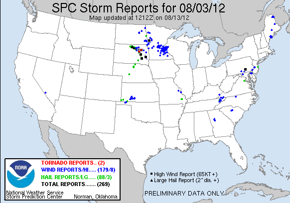
The NWS Storm Reports show a couple of isolated incidents of strong wind well east of Minot and some bona fide severe storms in north central SD, much farther than 50 miles from the radar at Minot, ND. So while dutch claims a successful haarp ring forecast hit that really wasn't, he totally failed to forecast severe weather for the areas that really did get hit with actual severe weather far to the south and east of Minot.


In the vid, he also spends some time talking up his "steam plumes" (debunked a thousand times over by now) erupting in select arid regions. He seems to try to make his audience think it never rains in places like AZ and NM in an attempt to brush off diurnal convection. Fact is, most locations in those states receive an average of 8 to 10 inches of rain a year, most of it falling during the summer monsoon season.

There's a little discussion in comments about birds on radar that started with somebody not believing an article about non-precipitation returns from the Northern Indiana NWS office.

Many non-Weather Features Visible on Radar this Morning.

Here's the comment:

look at the nws -northern indiana page (sorry but yt is a pita about linking so hopefully you find it) anyhow its the second news item titled "Many-Non weather features visible on radar this morning." While it is a complete bit of hogwash it is their spin on the very clear rings seen over indiana ohio and illinois. Notice they are forming concentrically around radars (which must be in the middle of lakes, because they blame the rings on birds taking to flight in the morning at sunrise)
keepItGoingg in reply to MeInTheCornfield (Show the comment) 2 days ago

The only hogwash is in that comment.

One last thing. Here's what dutch wrote in the description for the vid:

took TWO hours for this to upload?! 221pm cdt now.. and still have 51minutes upload time to go?! wtheck is going on.

Everything's a conspiracy to this guy.
 
Last edited by a moderator:
Yeah, thanks for your analysis. As a resident of Grand Forks who was tracking that system all day, I can atest as a personal witness that besides a few gusty winds across town early that evening, the real severe weather didn't start until the storms had passed well into Minnesota.
 
While it is a complete bit of hogwash it is their spin on the very clear rings seen over indiana ohio and illinois. Notice they are forming concentrically around radars (which must be in the middle of lakes, because they blame the rings on birds taking to flight in the morning at sunrise)

This illustrates something that is maddening. The conspiracists are utterly clueless about how radar works but they KNOW that the meteorologists and everybody else not "awake" are either lying or stupid.

Those concentric rings near water bodies are most likely purple martin pre-migratory colonies. Once they are done nesting they flock up in to huge colonies that can number into the millions. They are the only bird species that I know of that regularly fly high enough and in big enough numbers to be detected by the radar like that and that dispersal pattern in concentric rings is unique to martins. Interestingly, Mexican free tailed bats have a similar radar signature except that they are nocturnal so their appearance on radar occurs near sunset.

'Large-scale Mapping of Purple Martin Pre-Migratory Roosts,"

http://elibrary.unm.edu/sora/JFO/v069n02/p0316-p0325.pdf

The following link is a bird watchers blog post from 2010. Notice the location of the roost rings then and in screen capture in that recent post by the NWS in Indiana. Purple Martin roosts can shift around from year to year but the good spots are re-used for many consecutive years.

http://mypurplemartinblog.com/2010/08/purple-martin-roost-rings-on-radar/

Here is another paper on tracking purple martins with radar:

http://www4.uwsp.edu/cnr/faculty/russell/images/purple martins.pdf

Furthermore, if you web search "purple martin roost ring" or loose terms like purple martin radar, you'll get abundant hits on web pages by bird watchers and professional ornithologists alike that have been using weather radar for over a decade to track movements of martins. Same thing for bat enthusiasts.

Now these "roost rings" are different from the overnight broad clutter as I depicted in posts #51 and #52 in this thread. Those are also non-precipitation returns caused by the radar detecting birds but the behavior and species composition of the birds detected differs.
 
As for Dutch. I've challenged him to plot his rings on the map ahead of time and them overlay subsequent SPC reports. Never happens. Never will.

He says that only he names towns and that 100% will be hit and that SPC just operates in vague generalities. The thing is, the named towns are rarely actually hit and the SPC is much more specific than the 1 to 3 day time windows that Dutch gives. Comfirmation Bias and Shoehorning are the only things that keep his "success rate" from being essentially zero.
 
8/7/2012 -- HAARP ring / Circle Sweep forecast (2am Aug 7, 2012) = Central South Texas

http://www.youtube.com/watch?v=dMFs4xK9QSA&feature=channel&list=UL


I didn't need to watch the video to know that this was going to be the Mexican Free Tailed Bats causing ground clutter. I did watch the video and it was. Classic roost ring returns show around the major colonies in the area right as sunset (sunset spike is visible in the unfiltered displays). There was one "flash" do the southeast of Austin that was not bats but it looked more like the type of return that is cause when super-refraction bounces the radar signal off the ground.

So here we have emerging bats showing up on radar that are supposed to be predictive of severe weather occurring within 24-48 hours (maybe up to 72). There is a slight chance of dirunal convection every day but no widespread or unseasonal weather is likely.

I did not make any statements about his forecast. I simply pointed out in comments what the "frequency explosions" really were with suggested search terms so my explanation can be checked. The following are my four posts (I hate the way that youtube comments are ordered and that you cannot link in them). I just used the colors to separate the posts. Each color is a separate post.

Once the bats have dispersed you get generic diffuse clutter throughout the radar's coverage. I don't know what the later pulse was but the "frequency explosions" that occurred at sunset (note the sunset spike) were definitely bats. I have several of the colonies marked in Google Earth if you'd like to do an over-lay.

Here is a study from the 1990's where bats where radar was used to study bats in that area. It has a couple of example screen shots of the typic radar signature of emerging bats.
VOLUME 14, NO. 3 Fall 1996
Bats Aloft: A Study of High-Altitude Feeding
An ongoing research project is demonstrating that Mexican free-tailed bats go to great heights to intercept some of North America's most costly agricultural pests . . .
McCracken, Gary F.

I am assuming you will dismiss my explanation of the "frequency explosions" around Austin so I encourage you to seek third party information. Google Search "Mexican Free Tailed Bats" and "weather radar" together. Or search for "bracken bat cave radar" without quotes. There are numerous papers by biologists on the topic where bat emergence was noted on radar and the observation ground-truthed by going to the site and observing the animals that were showing up on radar.

If you look at the unfiltered data you will see that the clutter on the intellicast maps here comprises individual "clumps" that spread in a radial fashion right around sunset. The Plymouth loop you show at 3:41 illustrates this well. If you use Google Earth to find the center of what your refer to at 3:41 as "frequency explosions" you will see that the returns are centered on features like Bracken Cave and Congress Avenue Bridge. It's Mexican Free Tailed bats emerging to feed.


I think I was reasonably polite. We shall see how he responds and if he is honest in his response after he deletes me and blocks me from defending my position.
 
I am probably just going to cause a backfire effect with too much data posted too quickly but I added the following comment to that vid anyway:
=AkJ6PKa-r20

In the next vid, skip to the 2:15 mark or so for radar info.
=fAZ87Lz6rBU

Purple Martins show up in almost the same way on radar except they emerge at first light. August is peak season for both due to this year's fledgelings joining the flocks.
=s3gcCUzSbhY

Also, check out "SOAR" or "Surveillance of Aerial Ecology Using Weather Radars"
 
Last edited by a moderator:
Remember in July Dutch claimed that Derecho was a new made-up term? (an easily debunked claim).

Well I was just doing a search for "HAARP Florida" to see if there were any recent videos about the conspiracy generated from my home state and ran across this video.

http://www.youtube.com/watch?v=kCnP8MrzPFk

A comment to Dutch reads:

in continuation the ring you point out in citrus is an outflow boundary , the bow shape on the leading edge of the squall line id called a DERECHO a band of thunderstorms causes this its a natural common meteorological occurrence

So he should have been aware of the term prior to this year's news-making derecho.
 
Dutch has posted a link that he feels has completely validated his theory. I have not had the chance to read every page but I hope we can get some discussion going over this. By what I've seen this company uses microwave beams directed at clouds to lessen the intensity of storms. Although this may show that weather modification is possible using weather radar, it still directly contradicts Dutch's theory that radar creates or intensifies storms. So as far as I'm concerned, right now this page is just a bad misinterpretation on Dutch's part to attempt to validate his beliefs.

http://www.aquariusradar.com/index.html

The web page is very amateurish, it looks like the guy designed it himself. Half of the internal links are broken. According to whois, I believe it's owned by one Thomas Maxwell an "Old Homeboy Scientist thinking outside the box." Here's his Twitter account: https://twitter.com/tmax123_tom

AquariusRadar.com claims that radars can induce small temperature changes in a cloud base that can then have some kind of multiplying effect on the whole storm. The hypothesis has never been tested. Probably because it requires the use of defence department radars.:rolleyes: If this idea had any validity, then wouldn't radars accidentally wreak havoc on the weather all the time and everywhere?


One amusing note is that Aquarius Radar seems to be getting attention from the lunatic fringe. So much so that the home page has the following disclaimer:

This website has nothing to do with HAARP?, ionosphere heating?, ChemTrails?, weather warfare, or any of the myriad nonsense sites devoted to government conspiracy theories concerning weather modification!
Content from External Source
It looks like the HAARP disclaimer was added within the last two years or so as it does not appear in the WayBack Machine archive from Feb 10 2011.
 
Amateurish and totally devoid of any real science.

Much of what is covered on these pages are the result of observations by the site author over a span of several years as an operator of high powered pencil beam radars.

I just about fell over when I saw this one:

Microwave energy is a new form of weather modification difficult for many to understand.

LOL... Lay it on me, pal.

The choice of radar debunks the foundation of the hypothesis, which is that the radar heats up water droplets. The radars of choice are radars designed for precision missile tracking and were used in the apollo program. So here's where the science fails. First, the term "microwave" covers a broad range of wavelengths/frequencies from 1mm to 1m/0.3 GHz to 300 GHz. Only certain frequencies will heat water, one of them is 2.45 GHz used in microwave ovens because that frequency is partially absorbed by water in the liquid phase. The other frequency in the microwave range that heats water is 22 GHz but that heats water in the vapor phase only. It's such a narrow effective bandwidth that even a tiny deviation from the absorption frequency will be transparent or scatter off water depending on waters phase. WSR-88D NEXRAD radars transmit at between 2.8 and 3.0 GHz, far enough outside the absorption band as to be virtually ineffective at heating water. Even if radar transmitted at 2.45 GHz there are other reasons such as beam spreading and the inverse square law, among others, that would make even short range transmissions ineffective at heating water droplets in the open atmosphere. The radars that AquariusRadar wants to use transmit at 5.4 to 5.9 GHz, and you can't just change the frequency on those things like turning a dial on your radio. Those radars are designed for long range tracking of small high speed objects, if the frequency range used were absorbed by water at all the attenuation would render those radars useless for their designated mission. Same goes for weather radar.

http://en.wikipedia.org/wiki/Microwave#Heating_and_power_application

http://en.wikipedia.org/wiki/AN/FPQ-6

Radar Ground Station Characteristics
------------------------------------

AN/FPS-16 AN/FPQ-6
--------- ---------
Frequency band (MHz) . . 5400-5900 5400-5900
Peak power (MW) ...... 1.3 3.0

The FPQ-6 class of instrumentation radar and similar DOD radars destined for retirement are the best candidates for the AquariusRadar job.

http://www.aquariusradar.com/idealcandidate.html

WRONG.

The claim is made that a "radar rain shadow" is evident in rainfall distribution.

The powerful radar is located in southern Walton county. The eastern boundry of Walton is common to the western boundry of Holmes and Washington counties. Prevailing storm tracks are SSW to ENE, placing Holmes county directly downwind. For the 8 year period from 2001 to 2008, a dramatic decline is noted in the rainfall reported by the Florida Department of Forestry between the recording stations of Walton and Holmes counties. A significant change is noted in Washington and Jackson counties as well. As the distance from the radar increases and the microwave intensity decreases, the rainfall amounts increase back towards normal. Bay, Calhoun and Gulf county rainfall amounts progressively increase to the levels of the upwind Santa Rosa and Okaloosa counties.

A link to a cheesy amateurish map here:

http://www.aquariusradar.com/rainshadowmap.html

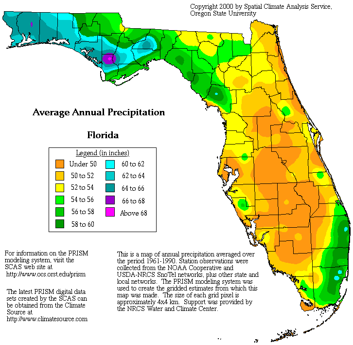
However the rain distribution described matches almost exactly the rainfall distribution averaged from 1961 to 1990. The rainfall distribution pattern used as "evidence" is pretty much the way it is in that part of Florida.


http://www.worldatlas.com/webimage/countrys/namerica/usstates/weathermaps/flprecip.htm

The references to NEXRAD are only for the purpose of collecting rainfall data, because one of the things NEXRAD does is calculate the quantity of precipitation. The proposal has absolutely nothing to do with NEXRAD being used to modify the weather.

Fortunately, the NexRad data and the associated software and the widespread CoCoRAHS network that has been developed to work with rainfall data can now be used to develope the data base to show the water transport over a period of time. The hydrology transport concept cannot be proven without long term NexRad/CoCoRAHS data trends.

Of course dutchsinse would latch onto the pseudo-scientific dribble presented on that website.

Perhaps Debunked: AquariusRadar.com should have its own thread?
 
Last edited by a moderator:
Dutch has found a new documentary (one of your typical conspiracy shows) that he has misinterpreted as solid proof that those radar rings is HAARP. This is the first documentary I've seen that actually talks about these various radar returns.

http://www.youtube.com/watch?v=esuCgvQEQRk

Regardless, there is nothing new to debunk in this video.
 
That "documentary" was so bad I wrote to the producers. Not a one of their guests had any expertise in any of the related fields, they just regurgitated some crap they read on the internet. The very first incorrect statement actually relates to this thread where the first guest, Bill Birnes, says that HAARP transmits VLF waves up into the atmosphere but as the paper highlighted in this thread demonstrates, HAARP actually transmits in the HF band and with a few specific techniques can cause a small region of the ionosphere to produce VLF "whistler waves". The rest of the so called "documentary" is just all downhill from there.

Thought I might as well toss the following into the mix as another example of how little Dutch understands, especially since rezn8d (Jim Lee) alerted him to it.

Proof HAARP & RADARs can manipulate the atmosphere , not just observe it…

Thanks to Jim Lee for this… his description when sending this to me : “Proof HAARP radars modifying climate for geoengineering!”

full story here:
http://rezn8d.net/2013/01/15/radio-...plication-to-atmospheric-methane-destruction/

After reading all the information, I agree, for sure this is proof beyond any shadow of a doubt, that RADAR and HAARP can be used to manipulate the atmosphere, not just “observe” it…. In case there is any question what kind of RADAR I’m referring to, I am talking about NEXRAD RADAR or other facilities which can target a MHz or GHz signal.

In my opinion, this is amazing proof that the use of frequency in the single MHz spectrum, can be used to ignite , or better put in their own words ‘ DESTROY ‘ methane in the atmosphere.


The source is an article from a climate blog that has a disturbing pseudo-scientific alarmism to it.

http://arctic-news.blogspot.com/201...ation-to-atmospheric-methane-destruction.html

In a nutshell it's a proposal from someone named Malcolm P.R. Light, apparently more of an activist than a scientist. The article/proposal is full of unsupported claims, some of which include that the Arctic will be totally ice free year round by 2015 and another is that all life on Earth will be extinct by 2050... but his idea can save us. The author claims that transmitting radio waves into the atmosphere at 13.56 MHz will "destroy" methane.

I'm pretty sure he's just making that up, but oddly enough I couldn't find a reference in the article/proposal to any papers involving a commonly used industrial deposition process using radiofrequency methane plasmas such as Particle Collecting in a 13.56 MHz Radiofrequency Methane Discharge. But that process uses an RF modulated high voltage discharge in a vacuum chamber, a far cry from transmitting 13.56 MHz radio waves into the atmosphere, or even the ionosphere, to achieve the same result.

Oh, and nearly all the references are self-citations to the authors own blog and a geo-engineering blog the author is also associated with. Not a single reference about using radio waves to decompose methane, but there is a lone reference to the spectroscopy of methane, like absorption bands and such.

Apparently Mike Janitch and Jim Lee think this is happening and is therefore proof that the weather is being manipulated. Well dutch you might have read it, but you don't have the background to understand it, much less scrutinize it and realize that it's bunk too... just like you.

So rezn8d told dutch about some stuff some guy made up on some blog. Three blind mice, anyone?

Heh, dutch really steps in it this time when he says:

An amazing find here. all skeptics who said RADAR cannot be used to manipulate the atmosphere will need to re-assess their positions, and issue retractions where necessary.

Think we'll ever get a retraction of any sort from one Michael Janitch?
 
He thought that smoke from prescribed fires showing up on visible satellite in the south during the burn season was volcanic plumes. Burn plans and burn reports were provides to him as well as explanations for why the burns were occurring when they were and how prescribed burning is conducted (timeing etc...) and the natural tendency of fires to flare during the early and mid afternoon when mixing is greatest and relative humidity is lowest.... His subscribers that lived in the area even provide eye witness reports of woodland fires. He stuck to his story and disappeared all contrary information. He was blatantly wrong and refused to retract his claims. He also refused to ground truth his claims himself even though he lived very near many of the "plumes".

If he can't get something as simple as identifying smoke on visible satellite (or the fires themselves at night on infrared imagery) then there is no hope that he'll understand all the different types of radar technology.

He's got a video right now where he's freaking out about chaff deployments around Key West. He thinks the colors on the radar are "frequencies" and can't figure out why there's nothing on the visible or infrared satellite. If he understood the technology of NEXRAD at all he'd know that he could go to Weather Underground and look at the individual tilt angles and using a little trig. figure out the elevation and fall rates of the stuff that is showing on radar. He would then be able to estimate particle size and know that the stuff showing on radar isn't "frequencies" or nano particles but is really big bits of stuff that are deliberately really reflective of radar signals. None of that reality fits his narrative though.
 
Dutchsinse's theories and understanding of weather radar are so laughably uneducated and silly, it would be sad if not for all the followers he has that buy into his crap. I work for the NWS - as an electronics technician - and part of my responsibilities include maintenance and repair of the WSR-88D radar. I often go to his Facebook page and try to explain to his fans what they are actually seeing versus his nonsensical gibberish, only to have my comments either deleted or completely ignored. Normally, I would not care - to each their own - if they want to believe that crap, fine, let them believe it. But lately, I am noticing a growing anti-government rhetoric spreading along with a lot of sanctioning of violence against federal entities and that scares the heck out of me as a federal employee, especially one who works for an agency that is, essentially, being accused of murder by these people. My feeling is it is just a matter of time before one of them gets in their head to act upon their growing mistrust of federal agencies.

Someone asked the question somewhere in one of these threads wondering if NWS employees have been bothered by these people? Yes, they have. I know a couple meteorologists that have taken calls from angry citizens asking about chemtrails. A co-worker of mine was approached at a local university by what he described as a rather odd young man who wanted answers as to what we were doing with that "big white ball on top of that tower". It's scary.

On a technical note, as has been discussed numerous times here before, the WSR-88D CANNOT see "HAARP". A WSR-88D transmitter is tuned to a site specific frequency between 2.7-3.0 gigahertz. Each radar site has its own site specific frequency somewhere in that range. For example, let's say a particular WSR-88D's operating frequency is 2725 MHZ. Another site might operate at 2775 MHZ. Those sites will ONLY operate at or very near that frequency - it never changes. Their receiver circuitry is set up to filter out EVERY incoming type of RF energy that is not operating at or near those frequencies. Just like your car stereo only receives the particular channel you are tuned to, a radar will only "see" energy that is at or near its own frequency.

Good old Dutch seems to think the 88Ds can "see" HAARP because, according to him, they "pulse" at 12.4 MHZ. Not sure where he gets that from, but the closest thing I can think of is somewhere along the lines he saw specifications referring to the output pulse spectrum width and mistakes that for that actual output pulse frequency.

In addition, he loves to quote the maximum output power of the WSR-88D at 750KW and claims that is enough to reach the ionosphere where all the shady, underhanded manipulation of the weather takes place (apparently). First off, that is a measurement taken at the neck of what is called the klystron inside the transmitter assembly. Second, that is maximum power rating - the 88Ds never run that "hot". More typically, we keep them around 650-700 KW. And lastly, he obviously has no understanding of what is called path loss - the attenuation of that power as it travels through waveguides and other cabling to reach the antenna feedhorn in the radome (white ball). By the time the pulse is actually sent out into the atmosphere, it is typically around 400-420 KW, where it is quickly attenuated even further as it travels outward. By the time any returned energy makes it back, it is in the microwatt range - so much so that the antenna and receiver have circuitry built into them to significantly amplify the returned signals so they can even be made use of.

My points being, the WSR-88D cannot see HAARP; it does not have nearly enough output power to reach the ionosphere, and it certainly is NOT being used to control and or modify the weather! Now about that retraction, Mr. Dutch??
 
Thanks for your input ssfor27. I share your concerns. Another thing that disturbs me is some of his followers have advocated violence against radar stations such that any radome is a potential target. Scary stuff.

The following reply dutch made to one of my comments is priceless...

timsolrey wrote:
Any radar technician or meteorologist can tell you dutch doesn't know what he's talking about. For example, silver iodide is dispersed as a vapor, not powder, because in vapor form its size and shape are close to that of ice crystals so it's used specifically for ICE nucleation. Those strips of chaff aren't "gel", they're vapor deposited aluminum on mylar. He got the idea that 13.56 MHz radio waves could destroy CH4 in the atmosphere from a proposal on a blog but the idea is total nonsense.

This is his reply:

dutchsinse wrote:
tim.. you're 100% wrong.. silver iodide.. lol.. its an element.. not a vapor dude..
the gel like chaff strips... appear rubbery...
and the 13.56 comes from scientists and experiments not from a Blog..
you're such a dipshit stalking denier.. if anyone wants to have fun..
search Timsolrey dutchsinse on google.
You'll see a forum of denier fools who said last year RADAR cannot heat the atmosphere
Hey tim.. aren't you the guy who accused me a FRAUD and HOAXING the RADAR?
Yep.. thats you! lol

wow... just, wow.
 
Thanks for your input ssfor27. I share your concerns. Another thing that disturbs me is some of his followers have advocated violence against radar stations such that any radome is a potential target. Scary stuff.

The following reply dutch made to one of my comments is priceless...


This is his reply:


wow... just, wow.

He's been calling for his followers to donate to his cause just to annoy the "haters." He's already made up his mind that HAARP rings are real, and he's so far into the delusion at this point that nothing will make him look at the actual science.
 
He's been calling for his followers to donate to his cause just to annoy the "haters." He's already made up his mind that HAARP rings are real, and he's so far into the delusion at this point that nothing will make him look at the actual science.

Speaking of too far into a delusion....OMG...the guy has seriously "jumped the shark" this time.....now he has discovered a "HAARP Ring heater".......wow....


http://sincedutch.wordpress.com/201...ional-airport-radar-causes-real-time-heating/
 
And his followers are reposting it.

I am getting concerned that some nutter is going to try to stop a plane or a radar, and folks will die.
 
And his followers are reposting it.

I am getting concerned that some nutter is going to try to stop a plane or a radar, and folks will die.

That is my biggest fear also, especially being an employee of the NWS who works on the WSR-88D and spends a lot of time in government vehicles as well as the radome of the radar. Out of those two (weather office or aircraft), the easier of the targets would be a stationary, ground based weather office.

The violence and mistrust of the government in this country has really ramped up lately. It continues to be my belief that it is only a matter of time before someone with a less than stable mindset decides to act upon their beliefs that they are being attacked if people such as Dutchsinse continue with this reckless and nonsensical course of action. I fear someone is going to get hurt or killed as a result.

I joined the NWS because of my interest in the weather and because I wanted to contribute to PROTECTING people and property, not harming them. Dutchsinse's accusations are incredibly offensive to me.
 
I've seen a few of his followers make threats against pretty much anything that looks like a radome or antenna, and against anyone associated with the NWS. I think we should start posting those kinds of threats.

Speaking of too far into a delusion....OMG...the guy has seriously "jumped the shark" this time.....now he has discovered a "HAARP Ring heater".......wow....


http://sincedutch.wordpress.com/2013...-time-heating/

Double wow.

And now for yet another demonstration that dutch has nary a clue.

In his blog post he says:

For sure its radio frequency heating of some kind, however NO RADAR at this Airport.

If not RADAR heating then some other HF signal causing it…

From what I can find.. there is a 123.00 MHz radio transmitter as well as a LASER CEILOMETER at the location …

It turns out there is a giant antenna at the ring epicenter. here is the antenna information

KPE801
Callsign: KPE801

Location: UNINCORPORATED, LA SALLE, IL

Owner: MENDOTA BROADCASTING, INC

License ID #: 1118734

That 123.00 MHz transmitter at the airport is the UNICOM channel.

Unicom has the same function at small and large airports. It's used for contact with the Fixed Base Operator, who sells fuel, supplies, and services to aircraft passing through. The only difference at uncontrolled airports is that the Unicom frequency (if it has one) also functions as the CTAF. For years all Unicom at uncontrolled airports was found on 122.700, 122.800 and 123.000. More recently, 123.050, 123.075 and 122.725, and 122.975 have become available to relieve frequency crowding. Other frequencies in the 136 MHz range may come available as well.

http://www.qsl.net/n4jri/apt_unc.htm

Official FAA data for the airport here:

http://skyvector.com/airport/VYS/Illinois-Valley-Regional-Walter-A-Duncan-Field-Airport

A laser ceilometer just bounces a laser beam off the bottom of the clouds in order to measure the ceiling, which is important information for pilots flying VFR (Visual Flight Rules) into uncontrolled airports.

http://en.wikipedia.org/wiki/Ceilometer

What he calls a "giant antenna at the ring epicenter", Callsign KPE801, isn't even at the airport, it's a couple of miles south. It's just a plain old radio tower in the middle of a field. The callsign KPE801 is licensed as a "Broadcast Auxiliary Remote Pickup" for an FM radio station owned by Mendota Broadcasting, Inc. KPE801 at a frequency of 450.02 MHz, is just a low wattage relay located between two towns with radio stations owned by Mendota Broadcasting.

http://wireless2.fcc.gov/UlsApp/UlsSearch/license.jsp?licKey=1118734

http://wireless.fcc.gov/services/index.htm?job=service_home&id=broadcast_auxiliary

http://www.interceptradio.com/fcc.php?scall=KPE801&cmap=1&cfreq=1&cpl=1&z=1

Of course he doesn't bother to check other providers to ensure it's not just a glitchy Intellicast software thing.

Debating this guy would be like shooting fish in a barrel.
 
http://www.youtube.com/watch?v=RNyNEnfN9L0

He's declaring victory in a giant Gish Gallop that ends in calling out "the skeptics". It repeats many of his previous errors. And since he still cannot tell the difference between smoke, steam, and convective thunderstorms on a satellite image (he posted the other day that smoke from a fire in the Kisatchie National Forest in Louisiana was a steaming plume from a fracking well) I'm not going to waste my time. I'll just share his post.

This is a profound release, just put out by the US Naval Research Lab on Feb. 25, 2013...

...Any skeptic who said it could not be done, (for instance those at Realist News, or Metabunk just to name a few) NEED TO ISSUE FULL RETRACTIONS AND CORRECTIONS --- assuming of course they really are into science and not trying to just protect their egos

Edit: I didn't know this had already come up in another thread.

https://www.metabunk.org/posts/29345
 
Last edited by a moderator:
A discussion of dutch's take on that NRL experiment is on another thread starting at the following post:

https://www.metabunk.org/posts/29345

The portion of the ionosphere described in the experiment by the green line emission at 557.7 nm is for atomic oxygen, which would be a marker for the lower ionosphere at altitudes above around 90 km. One set of telescope images of the glow discharge from the experiment is time-stamped on 12 Nov. 2012 at 02:26 GMT, which would make it 5:26 pm (17:26) local Alaska Standard time (GMT -9:00), or about an hour or two after sunset when there would still be plenty of residual free electrons in the lower portion of the ionosphere for 4.34 MHz transmissions to interact with. When the press release mentions the "neutral" atmosphere they're talking about the portion of the lower ionosphere where ionization dissipates at night, however some residual ionization does remain. The emission of atomic oxygen puts the approximate altitude squarely within the ionosphere, but dutchsinse just doesn't understand this stuff.

http://www.nrl.navy.mil/media/news-...ificial-ionospheric-plasma-clouds-using-haarp

http://link.springer.com/article/10.1134/S0016793211070139?LI=true#page-1

http://onlinelibrary.wiley.com/doi/10.1029/JZ054i001p00007/abstract

http://en.wikipedia.org/wiki/Ionosphere
 
Last edited by a moderator:
Dutchsinse has fallen for the Aquiess scam/hoax:

3/9/2013 — Using frequency to perform Weather Modification over Texas — Spring 2012 operations — Aquiess and Sci-Blue

http://sincedutch.wordpress.com/2013/03/09/392013-using-frequency-to-perform-weather-modification-over-texas-spring-2012-operations-aquiess-and-sci-blue/


SMOKING GUN on an active program using frequency to control the weather in the continental United States.
Anyone saying it could not be done, (weather modification using smaller stations over the United States) well.. it would appear there are already some fairly large companies DOING IT.
In April 2012 — two companies using RESONANCE to perform weather modification over Texas– Confirmed by Aquiess and Sci-Blue ..

https://web.archive.org/web/2015090...eblog/permalink/aquiess_weather_modification/
 
Last edited by a moderator:
He doesn't want to understand. I've seen him insult and argue with every expert in every discipline he mucks about in. He [...]

He's also promoting as proof one of his youtube cohorts that stuck a bunch of rods on the end of a puny truck mounted CB antenna then boosted the power way beyond what the antenna can handle, melting some of the rods while producing a corona discharge. I get the impression that they actually think they've "discovered" something. [...]

http://www.youtube.com/watch?v=gm6qV2uL2tw
 
Surprise, surprise... I've been blocked by the owner of that video. So I thought I'd post the following totally foolish comment by one of dutch's sheep because it demonstrates just how [...] his followers really are.

timsolrey 12 hours ago
You obviously don't have a working knowledge of radar nor do you know how to interpret radar signatures. How many years did you study and work with radar?
Reply · in reply to Annie Wyers


Annie Wyers 10 hours ago
I read the specs for the manufacturer of Radome's. And I read Tesla's Patents for Radar. That's all I need to know.
The manufacturer claims that they can send "Any Wave", at "Any Frequency" back-and-forth between Radome's.
Reply · in reply to timsolrey

Whoa.

To top it off, [...] dutch makes snarky comments, which are received in email, then deletes them from the video so his [...] followers can't see his true colors.

Dutchsinse wrote:

mr. know it all ..

hey everyone.. did you know tim is from a forum which has dozens of people dedicated against me?!

LOL...

He's with the same bunk website that claims to have "debunked tesla"

quote you! "RADAR cannot be used to heat the atmosphere"

HAHAHAHAH

That's right, radio waves can not be used to heat the atmosphere, below the ionosphere that is. He doesn't realize that a corona discharge is non-thermal but the reason the rods that were haphazardly stuck to the antenna melted was because their current-carrying capacity was greatly exceeded.
 
I'm concerned this is getting a little too heated and personal. Metabunk has a politeness policy to facilitate communication. You can expose the falsehoods of someone without calling them names. I have edited some of the posts above with this in mind, and would appreciate it if people could keep the politeness policy in mind

https://www.metabunk.org/threads/1224-Politeness-Policy
 
Last edited:
Agreed Mick. I am trying my best to avoid getting sucked into personal attacks. I advise anybody the communicates with Dutchsinse to avoid any personal attack so as to disallow him that distraction from the argument. Also, save copies of the correspondence in the case that he goes on a deleting spree and then makes incorrect statements about your claims or position afterward.
 
Sorry about that Mick. No excuse, but those people just push my buttons sometimes.

Such as when one cannot respond to outright lies when one is blocked.

dutchsinse 11 hours ago
annie.. watch out.. tim (the guy speaking to you) has "debunked" Tesla with his other denier buddies.. lol.. riiight
Silly us for believing in tesla.. the skeptics claim he is a nobody who didn't invent anything of importance... and they say he was quote "just a really good self promoter"
HAHAH
Thats the guy going off on you... that the quality of his character and the level of his intellect is low -- although hes a great parrot.. when it comes to innovative ideas, he's in the stone age.

I've never posted a comment to the Tesla Overrated, Debunked thread. The only comments I've made regarding Tesla, here or anywhere else, have been to address the myth that Wardenclyffe was to produce "free" energy. I think he was a great inventor, but he was just one of many great inventors at the time. It's widely acknowledged that along with his various innovations he was also a showman, a mediocre scientist, a lousy businessman and likely suffered from obsessive compulsive disorder. As I see it, what's being debunked are the mis-conceptions.

Dutchsinse makes a lot of assumptions, but he doesn't know me so how could he know that I've designed and built several buildings, a pedal powered washing machine, a solar powered cooling system for our house, designed constructed wetland grey water systems, or won awards for original processes and designs both in business and academics. Nah, never had an innovative idea in my life.

You're right Mick, no need to insult people like that, their own words are all that's necessary.
 
Just wanted to point out a few things I noticed yesterday that Dutch found significant, in case people were wondering:

1) Dutch pointed out a quick drop in temperatures here in the Upper Midwest that occurred last night.

WOW @ the temps dropping quickly up north.. we're talking -24F / -31C

I'm not sure if he finds this strange or something that can't really happen in "normal" weather. It's called radiational cooling, and in a landlocked flat locale such as the Dakotas, it can have quite an impact on temperatures, assuming:

- Clear skies
- No wind

Temperature here dropped to -23 last night in a matter of hours in an environment free of clouds, and with winds at 3 knots or less. It's not the most common event around here, as we usually have a good bit of wind most of the time, but it has been noted before and is indeed impressive on a scale such as yesterday.

2) A new pulse/HAARP ring/Scalar Square video, but lacking any voice-over. There is a lot of gesturing around with the mouse at various radar anomalies. I am assuming he is suggesting the same thing he has always had, which has already been mentioned several times in this thread and in others.

http://www.youtube.com/watch?v=65VskrFCCz8

Explanation of video can be found here:
http://sincedutch.wordpress.com/201...-ring-confirmation-springfield-nixa-missouri/

Interestingly, he did mention the "professionals" have forecast severe weather across the South today (Monday), which is the first time I've seen him give a nod towards whom I can only assume is the Storm Prediction Center. Although we already know what his explanation for that forecast is, here is the technical discussion from SPC:

...THERE IS A SLGT RISK OF SVR TSTMS ACROSS PORTIONS OF KY AND TN
SWD INTO THE SOUTHEAST...

...SYNOPSIS...
BROAD CYCLONIC FLOW ALOFT WILL CONTINUE TO PREVAIL ACROSS MUCH OF THE U.S. THIS PERIOD...AS A TROUGH CENTERED INITIALLY OVER THE PLAINS STATES TAKES ON A MORE NEGATIVE TILT AS IT SHIFTS EWD/NEWD ACROSS THE GREAT LAKES/MIDWEST REGION.

AT THE SURFACE...A LOW INITIALLY INVOF THE LOWER OH VALLEY IS PROGGED TO MOVE NNEWD WITH TIME...EVENTUALLY MERGING WITH A SECOND/MORE NRN LOW AND RESULTING IN A DEEP CYCLONE OVER THE UPPER GREAT LAKES REGION BY THE END OF THE PERIOD. AS THIS LOWER OH VALLEY LOW DEVELOPS NNEWD...A TRAILING COLD FRONT IS FORECAST TO SWEEP ACROSS THE LOWER OH/TN/LOWER MS VALLEYS THROUGH THE DAY. OVERNIGHT...THE FRONT SHOULD CROSS THE APPALACHIANS...AND APPROACH THE ATLANTIC COAST BY THE END OF THE PERIOD. CONVECTION ALONG/AHEAD OF THIS FRONT WILL POSE A THREAT FOR SEVERE WEATHER ACROSS THE MID SOUTH/SOUTHEAST REGION.

...ERN KY/MIDDLE AND ERN TN INTO THE CENTRAL GULF COAST REGION...
SCATTERED SHOWERS AND THUNDERSTORMS ARE FORECAST TO BE ONGOING ACROSS WRN PORTIONS OF THE RISK AREA EARLY IN THE PERIOD...AHEAD OF THE DEVELOPING COLD FRONT. THE CONVECTION IS PROGGED TO SPREAD EWD ACROSS THE RISK AREA THROUGH MIDDAY/EARLY AFTERNOON...AFFECTING TO SOME DEGREE THE POTENTIAL FOR WARM SECTOR HEATING/DESTABILIZATION. HOWEVER...GIVEN LIKELIHOOD FOR AT LEAST MODEST HEATING AND DEWPOINTS INTO THE 60S ADVECTING NWD ACROSS THE AREA...MIXED-LAYER CAPE OF 1000 TO 2000 J/KG SEEMS LIKELY AT LEAST LOCALLY. ALONG WITH INTENSIFICATION OF THE ONGOING STORMS WITHIN THE DESTABILIZING WARM SECTOR...A BROKEN LINE OF CONVECTION SHOULD ALSO DEVELOP FROM THE ERN KY VICINITY SWWD ACROSS THE TN VALLEY AREA IN CLOSER PROXIMITY TO THE FRONT DURING THE MID TO LATE AFTERNOON.

DESPITE THE UNCERTAINTY REGARDING CONVECTIVE EVOLUTION/MODE...DEEP-LAYER WIND FIELD EXHIBITING WEAK VEERING/INCREASING MAGNITUDE WITH HEIGHT WILL YIELD SHEAR SUPPORTIVE OF ORGANIZED/ROTATING STORMS. ALONG WITH POTENTIAL FOR LOCALLY DAMAGING WINDS -- PARTICULARLY WHERE STORMS CAN ORGANIZE INTO SMALL-SCALE LINES/BANDS...A FEW MORE CELLULAR STORMS WILL LIKELY BECOME SUPERCELLS -- CAPABLE OF PRODUCING LARGE HAIL. WHILE TORNADO POTENTIAL APPEARS SOMEWHAT LIMITED DUE TO SOMEWHAT MODEST LOW-LEVEL SHEAR EXPECTED ATTM...A TORNADO OR TWO MAY BE POSSIBLE WHERE LOW-LEVEL BOUNDARIES -- INCLUDING THE RETREATING DAMMING FRONT ACROSS THE NRN GA/WRN SC REGION -- COULD LOCALLY ENHANCE THE LOW-LEVEL SHEAR.

OVERNIGHT...STORMS SHOULD DIMINISH IN INTENSITY -- PARTICULARLY WITH NWD EXTENT WHERE LESS AFTERNOON DESTABILIZATION WILL TAKE PLACE. LIMITED SEVERE THREAT MAY LINGER ACROSS THE SOUTHEAST...AS THE FRONT
MOVES ACROSS THE SRN APPALACHIANS THROUGH THE END OF THE PERIOD.
 
Back
Top