J
Joe
Guest
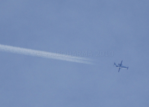
found it on flightaware landed in Cuba and returning to toronto flightradar made it look like it was going in circles didnt show Cuba landing . ") thanks
thanks
thanks thanks
we have a complete haze out spreading trails . nasty crap
Yes I am here to learn . Once i seen that a flight was going to Montego Bay and it just ended I figured I check another source .Oh I think I see what you mean. It looks like it's flying in a big u-turn south of Florida.
It actually Flew from Toronto, Canada, to land at Vilo Acuna, Cuba, then to land at Antonio Maceo, Cuba, then Back to Toronoto. Look at the FlightAware history.
Flights in Cuban airspace are not tracked, so it looks odd if you look at just the recorded track.
[Edit] See you figured it out already, cool.
N607PH flightradar ???
Wasn't there a case on the west coast where duplicate flight #s simultaneously in the air made the apparent position of the craft jump all over the place on the tracking sites?
Joe,
Scott Stevens has an advantage over you, since he is already at 8000 ft, but he has started to identify photographically ordinary commercial planes making what have historically been called "chemtrails". Have you been able to find any commercial planes making persistent contrails which would be considered "chemtrails"?

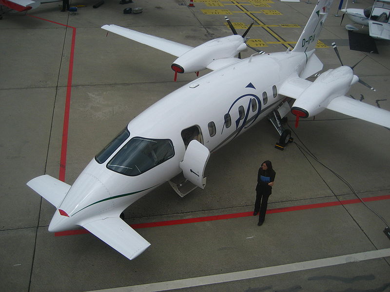
He was wondered that "a propellered Plane" makes contrails. But the P180 has two Turboprop-Engines, they are a kind of combination of both technologies, Propelered and Jet-Engine. So this plane can make "normal" contrails, and there are enogth pictures available from a P180 making contrails.
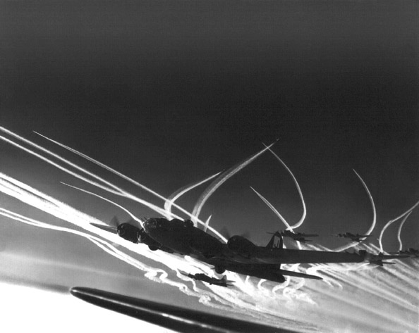
Besides which, ordinary propeller planes can also leave persistent contrails.
Yes. Most members of this forum should know that :-D. And we can distinguish "normal" contrails from aerodynamic contrails like these from your WW2-Picture...
The detail of propulsion is not really important... Older low-bypass jets, newer high-bypass jets, turbine-propeller (turbo-prop), piston engine and propeller, even ramjet (no moving parts).
They all burn hydrocarbon fuel and produce a water-rich exhaust. They will all make contrails in the right conditions. That condition being if the mixture of exhaust gas and the environment reaches water saturation at some point.
The WWII contrail producing planes were all piston engined (and had propellers).
External Quote:
The next most successful interceptors were the Mosquito (623 victories),[21] Spitfire XIV (303),[22] and Mustang (232). All other types combined added 158. Even though it was not fully operational, the jet-powered Gloster Meteor was rushed into service with No. 616 Squadron RAF to fight the V-1s. It had ample speed but its cannon were prone to jamming, and it shot down only 13 V-1s.[23]

Notice how far off shore the contrails extend. Those contrails were created over/near the coast over the course of several hours and have moved that far in 2 hours.
I can confirm from the ground, loads of contrails and natural cirrus over Gainesville today (after almost perfectly clear skies yesterday). Storms possible from tomorrow through Wednesday. Some chemtrails believers have noticed that "spray days" tend to precede rainy weather, but unfortunately they tend to get the causality confused, and think that the trails are causing the weather.The extensive trails over the Gainesville area that are oriented from SE-NW were created over the gulf in the MIA-HOU corridor (Hatrickpenry and Harold Saive are probably having fits today). The whole point of the illustration is how the cirrus and contrail cirrus are predictably present in the moistening atmosphere ahead of a storm system.
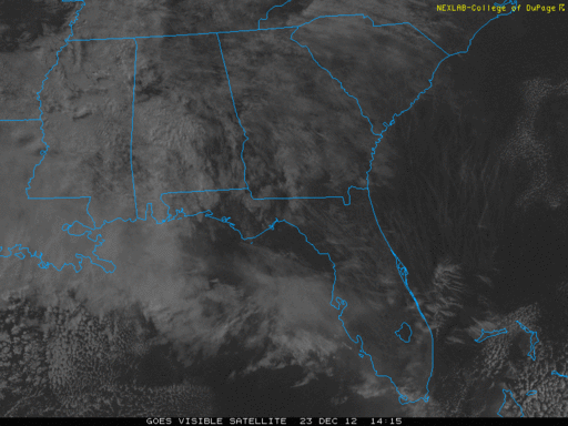
you got that rightExample of prime contrail weather. I've attached a visible satellite capture of the southeast US from 23 December 2012 at 0915 EST. There is a low pressure approaching from the west. The upper level winds are vigorous out of the west with calm cool high pressure in place at the surface (9AM observation from Jacksonville Florida is calm winds and a temperature of 39F). As is typical with a fast moving low pressure approaching from the west you get over-running moisture such that the atmosphere moistens from the top down. The extensive contrail field in the attached image is part of the cirrus clouds that are running ahead of the low pressure. Notice how far off shore the contrails extend. Those contrails were created over/near the coast over the course of several hours and have moved that far in 2 hours. The apparent sheet of contrails is primarily created by repeated flights along the east coast corridor with the newest trails being nearest the coast in this image.
View attachment 1233

Nice site . Looks like its all contrails ? Looks like crap makes it even colder without the sun .And check the Worldview
http://earthdata.nasa.gov/labs/worl...nd&time=2012-12-23T12:00:00&switch=geographic
Zoom out for the big picture

If i look south its a complete white out , north is blue and white some trails and sunny so guess im right on the edge . Compared to yesterday that had complete blue skies . Well at least i had a clear BirthdayIn some areas probably most of the cloud cover is from contrails, but if you zoom out to the bigger picture, that's quite a small amount of the total cloud cover nationwide. It varies though. Certainly has an effect.
a lot of trails off Georgia and the Carolina s
There was no Cirrus clouds Just Contrails that spread out . the sky started exactly as the top picture with blue skies and contrails as they continued all day leaving a total whiteout . I lived in Long Island for years and we did see many days of overcast conditions . Ive been in Florida for 20 years and only the past two years has it looked like this .This type of weather is very common in the eastern US, especially fall, winter, and spring when fronts move though once every 5 days or so. In active patterns like the present in winter we get low pressures every 2-3 days with maybe one day of sun. Here in southeast VA it will rain today, clear off tomorrow, weak high pressure will wedge in for Friday. Subsidence behind the departing low and downsloping off the Appalachians will mean clear skies for Thurs with maybe come diurnal puffy cumulus. Cirrus and contrails will prevail again Friday ahead of the yet another low that will cross the area on Saturday. The sky here in Virginia yesterday looked the same as in treasurecoastskywatch's Christmas post. There was a fairly shallow high pressure wedged down the east coast with the present storm system approaching. Ripping jet stream winds were advecting sheets of cirrus over top of the surface high pressure so the entire coast from Maryland to Florida has cirrus and contrails yesterday. That is the norm and not the exception in winter around here.
Maybe Germany but not sunny S Florida . I would say most other places you wouldnt notice it . But drier and tropical areas you would .We see this kind of weather rather often in Western Germany; humid warm fronts coming in from the Atlantic and meeting the edge of high pressure areas generally sitting more to the East, on the continental landmass.
Maybe people here are used to it more than elsewhere
I disagree on all counts. I've lived in Florida for about 9 years now. Although overcast conditions are not as common here as in some other places I've lived, they do happen and have happened before the past couple of years (I always take notice, because it reminds me of the weather back "home" - also in New York State). I noticed up here in Gainesville that there was a lot of natural cirrus cover first thing in the morning yesterday, and gradually persistent contrails adding to it as the day wore on.There was no Cirrus clouds Just Contrails that spread out . the sky started exactly as the top picture with blue skies and contrails as they continued all day leaving a total whiteout . I lived in Long Island for years and we did see many days of overcast conditions . Ive been in Florida for 20 years and only the past two years has it looked like this .
Well I guess Im Blind and didnt see the contrails spread causing the overcast conditions ? I believe Iv heard the BBC calls them Contrail Cirrus Clouds ? Today No Contrails at all ? Plenty of cumulus clouds and even rain but not 1 trail ?I disagree on all counts. I've lived in Florida for about 9 years now. Although overcast conditions are not as common here as in some other places I've lived, they do happen and have happened before the past couple of years (I always take notice, because it reminds me of the weather back "home" - also in New York State). I noticed up here in Gainesville that there was a lot of natural cirrus cover first thing in the morning yesterday, and gradually persistent contrails adding to it as the day wore on.
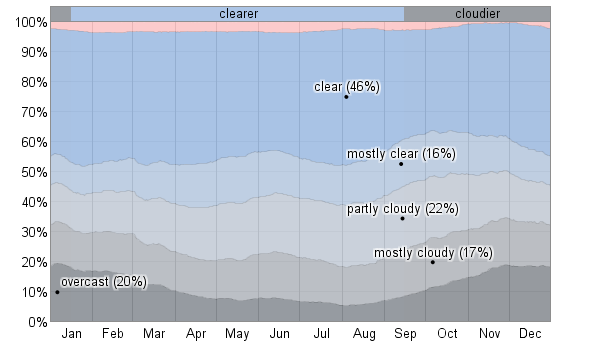
Edit: According to weatherspark.com, we are right about in the time of year when your part of the state gets these conditions most often: