But everyone sees contrail covered skies from time to time, very few of them go on to believe in scientifically wrong conspiracy theories about those contrail covered skies. What's are the factors that separate the conspiracy theorists from regular folk?
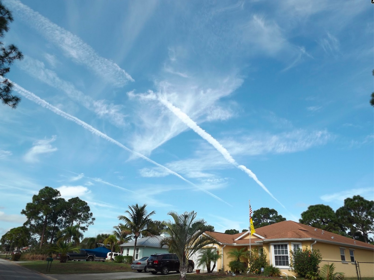
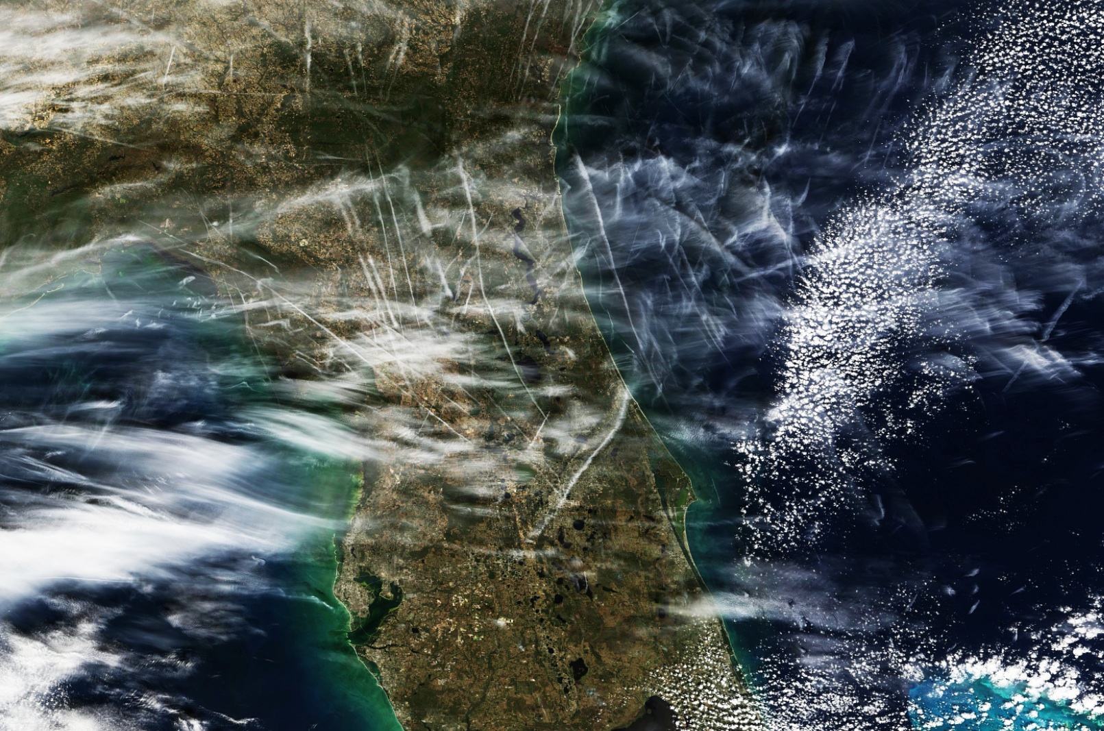
Maybe where you live they do . Only been almost 2 years since I seen this much . Have you ever surfed Mick ? Or at least in Florida where you sit waiting for a swell with nothing to look at but the sky ? Have you ever seen a rocket launch from Cape Canaveral from sixty miles away ? What I saw yesterday was much worse then Iv seen in quite a while . Too much air traffic in a short time to be airliners . Im sure more are coming to Florida this time of year but Flightaware doesnt support or show this amount of activity. IOt really doesnt matter much we could have a massive alien invasion (not from Mexico ) and the American Public wouldt care or even notice . Not that I belive in Space Aliens .
Maybe where you live they do . Only been almost 2 years since I seen this much . Have you ever surfed Mick ? Or at least in Florida where you sit waiting for a swell with nothing to look at but the sky ? Have you ever seen a rocket launch from Cape Canaveral from sixty miles away ? What I saw yesterday was much worse then Iv seen in quite a while . Too much air traffic in a short time to be airliners . Im sure more are coming to Florida this time of year but Flightaware doesnt support or show this amount of activity. IOt really doesnt matter much we could have a massive alien invasion (not from Mexico ) and the American Public wouldt care or even notice . Not that I belive in Space Aliens .
"Too much air traffic in a short time". Let's try to put numbers on that. How much air traffic? In what time?
Looking at your photo:
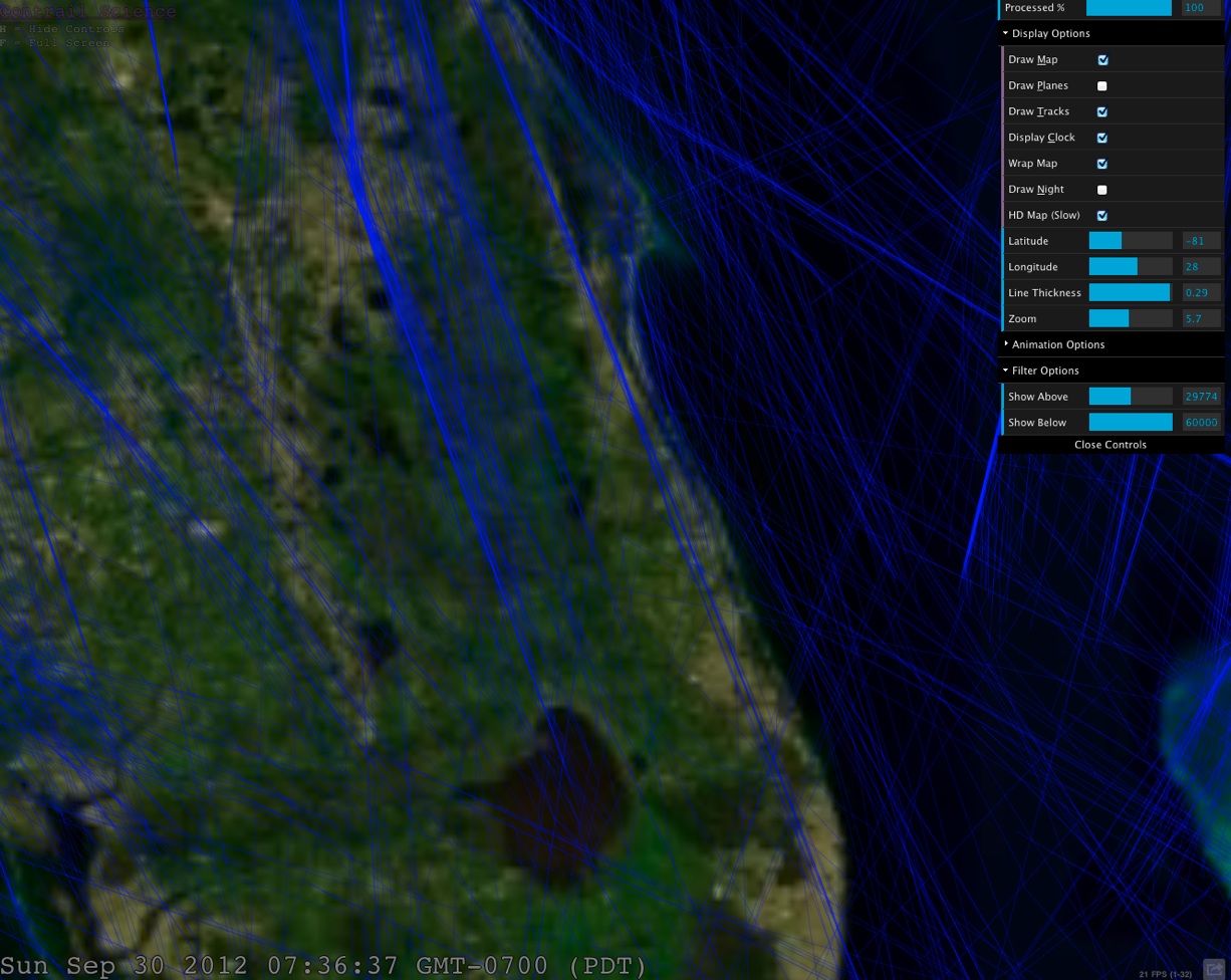
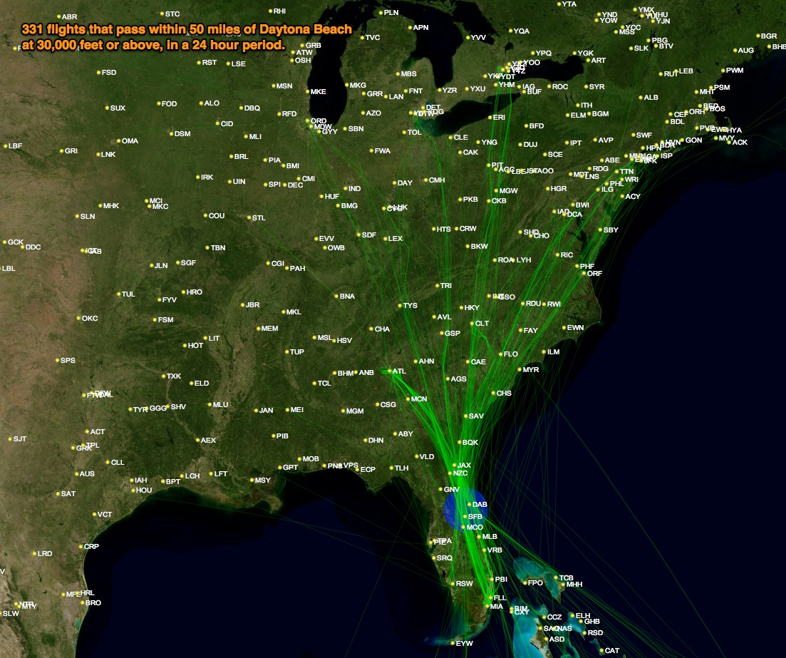
I see about seven trails, maybe ten tops. Probably laid within an hour of each other, based on their size. Now you live in Indian River County, right? (based on your blog). Well here's 24 hours of traffic in the general area. All the blue lines are ABOVE 30,000 feet, and hence potential contrails.
correct the southern edge of indian river county less then a mile of st lucie . why do most of the aircraft not show up on flightaware ? I know there is a delay of a few minutes
correct the southern edge of indian river county less then a mile of st lucie . why do most of the aircraft not show up on flightaware ? I know there is a delay of a few minutes
Iv tried going back to Sunday on Flightrader and even though ours skies were quite busy that day . It didnt look that way at all on Flightrader ? I do like the view from the cockpit that works nice with Google earth . Seems from what I see there seems to be more activity above then shows up . Does it track Military Flights ?
Iv tried going back to Sunday on Flightrader and even though ours skies were quite busy that day . It didnt look that way at all on Flightrader ? I do like the view from the cockpit that works nice with Google earth . Seems from what I see there seems to be more activity above then shows up . Does it track Military Flights ?
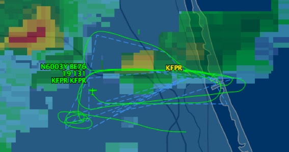
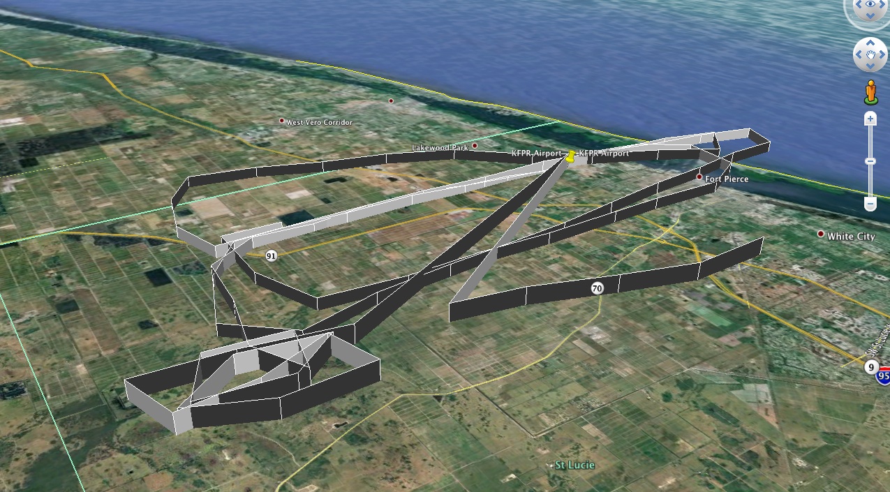
Thanks . Does it track all of them ? The Non Military ? Im watching this guy in a Beechcraft flying around in circles for the past few hours . must be training ? N6003Y
Thanks . Does it track all of them ? The Non Military ? Im watching this guy in a Beechcraft flying around in circles for the past few hours . must be training ? N6003Y
I think it tracks anything that would file a flight plan. But I'm not entirely sure. I know it does not track all the small general aviation planes flying visual flight rules.
N6003Y:
Looks like flight training to me. Some flying around in loops, and what looks like 2 or 3 landings at KFPR. That's the kind of thing I did when flight training.
I've lived on the east coast of Florida for 9 years. I'm still amazed at how much clearer the air is here on average than back home in Virginia. By clearer I mean much less particulate haze because of the maritime influence on our airmass. Summer high pressure up north means lots of pollution trapped under the cap. High pressure here in summer usually puts us in a maritime subtropical airmass. There have been tons of contrails since I've been here and the contrails were/are typically N-S oriented since most of our commercial traffic heads up to the hubs north of here. I haven't seen a change in frequency or duration of trails. I surf. I surfski. Surfski is 1-2X per day 5-7 days per week. I'm also a biologist and do field work a couple of days per week. I watch the sky a lot.
Too much air traffic in a short time to be airliners .
I just did a search for one way non-stop from South Florida (primarily WPB, MIA, FTL to JFK, Newark, LGA for next Sunday between 6AM and Noon. I got 39 flights. That's one way. There will be reciprocal going the other way so there will be 80 flights along that corridor in that 8 hour block. That also doesn't count flights to the NYC area that make stops. If I include those the search engine I use pegs out at 250 flights, a huge number of which are Delta to Atlanta and US Airways to Charlotte with connections to the NYC area.
That's a lot of flights and not inconsistent with the contrails along the east coast of FL last Sunday.
So im guessing you work for a university or the govenment ? ("That's a lot of flights and not inconsistent with the contrails along the east coast of FL last Sunday. )" I tried looking for those flights and didnt see what in saw in the sky ?
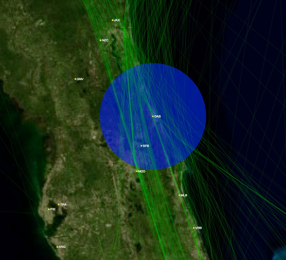
For a start though, here's the 24 hours of flyover traffic (above 30,000 feet). 181 flights within 50 miles.
Note the two fairly thick lines just to the left of VRB, thats a lot of flights on the same tracks. They go between PBI (Palm Beach) and MLB (Miami), but are not all from those airports, just using them as navigation points.
yes it seems that AA and delta along with many other airlines use that thick line or corridor on the path going south .so ive noticed . Between I-95 and the coast .
yes it seems that AA and delta along with many other airlines use that thick line or corridor on the path going south .so ive noticed . Between I-95 and the coast .
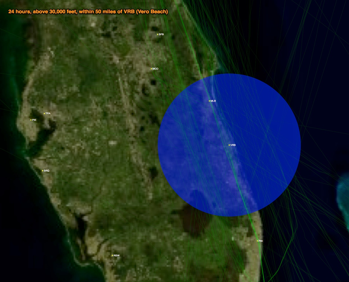
Here's the traffic within 10 miles of VRB, most of which is along the PBI-MLB track. I've sorted them by time, which is PST, so add 3. 10-12 EST would be 7-9 EST, which I've bolded.
00:11 Flight from null to null came to 9.150886 miles, at 37000 feet, at 30/09/2012 00:11:0701:28 Flight DAL146 from SCL to ATL came to 2.270393 miles, at 36000 feet, at 30/09/2012 01:28:03 03:34 Flight TA591 from IAD to SAL came to 1.4959974 miles, at 34250 feet, at 30/09/2012 03:34:20 05:09 Flight AAL701 from JFK to MIA came to 8.153371 miles, at 33500 feet, at 30/09/2012 05:09:56 05:17 Flight AA2129 from PHL to MIA came to 8.568564 miles, at 32350 feet, at 30/09/2012 05:17:12 05:24 Flight AAL873 from DTW to MIA came to 5.8931975 miles, at 33400 feet, at 30/09/2012 05:24:59 05:32 Flight AA2141 from EWR to MIA came to 1.9865572 miles, at 33000 feet, at 30/09/2012 05:32:16 05:36 Flight EGF3539 from CMH to MIA came to 6.3546743 miles, at 33800 feet, at 30/09/2012 05:36:02 06:08 Flight EGF3554 from RIC to MIA came to 1.9840847 miles, at 30100 feet, at 30/09/2012 06:08:57 06:14 Flight EGF3513 from CVG to MIA came to 6.7162743 miles, at 32300 feet, at 30/09/2012 06:14:27 06:17 Flight AAL1409 from YYZ to MIA came to 2.3802645 miles, at 32400 feet, at 30/09/2012 06:17:57 06:27 Flight AA2279 from LGA to MIA came to 6.118374 miles, at 31225 feet, at 30/09/2012 06:27:25 08:23 Flight AWE1019 from CLT to MIA came to 9.766798 miles, at 31300 feet, at 30/09/2012 08:23:28 08:27 Flight DAL317 from ATL to MBJ came to 6.4649973 miles, at 38000 feet, at 30/09/2012 08:27:43 08:55 Flight UA1050 from EWR to CUN came to 8.646036 miles, at 36000 feet, at 30/09/2012 08:55:04 08:57 Flight FL1068 from MCO to MBJ came to 5.828069 miles, at 34200 feet, at 30/09/2012 08:57:54 09:04 Flight TRS1068 from MCO to MBJ came to 5.9818344 miles, at 34200 feet, at 30/09/2012 09:04:18 09:06 Flight AAL1985 from ORD to SJU came to 5.615669 miles, at 36100 feet, at 30/09/2012 09:06:09 09:09 Flight N117LR from BQK to MIA came to 6.095153 miles, at 30500 feet, at 30/09/2012 09:09:25 09:29 Flight ACA916 from YYZ to MIA came to 4.5768485 miles, at 32000 feet, at 30/09/2012 09:29:30 09:51 Flight WS2702 from YYZ to MBJ came to 3.5402114 miles, at 36275 feet, at 30/09/2012 09:51:52 09:57 Flight WJA2702 from YYZ to MBJ came to 3.591507 miles, at 36000 feet, at 30/09/2012 09:57:40 10:18 Flight AAL1497 from YYZ to MIA came to 3.5958645 miles, at 33900 feet, at 30/09/2012 10:18:55 10:20 Flight AWE1831 from CLT to MIA came to 2.751193 miles, at 30800 feet, at 30/09/2012 10:20:55 10:27 Flight FL1056 from ATL to MBJ came to 3.5509522 miles, at 40425 feet, at 30/09/2012 10:27:53 10:32 Flight TRS1056 from ATL to MBJ came to 3.0965903 miles, at 40000 feet, at 30/09/2012 10:32:23 11:02 Flight WS1140 from YYZ to MIA came to 0.9861633 miles, at 32075 feet, at 29/09/2012 11:02:04 11:07 Flight WJA1140 from YYZ to MIA came to 1.0407977 miles, at 32800 feet, at 29/09/2012 11:07:39 11:23 Flight AA1623 from EWR to MIA came to 6.97712 miles, at 32400 feet, at 29/09/2012 11:23:55 11:37 Flight AA643 from RDU to MIA came to 3.2726011 miles, at 34575 feet, at 29/09/2012 11:37:28 12:07 Flight DAL930 from LGA to FLL came to 7.497039 miles, at 38000 feet, at 29/09/2012 12:07:32 12:23 Flight EGF3546 from CLT to MIA came to 9.415609 miles, at 33000 feet, at 29/09/2012 12:23:17 15:21 Flight SWG4746 from CVG to MBJ came to 3.5194414 miles, at 37975 feet, at 29/09/2012 15:21:55 16:01 Flight EGF3536 from CLT to MIA came to 5.19924 miles, at 35900 feet, at 29/09/2012 16:01:54 16:21 Flight from to came to 3.5237758 miles, at 36350 feet, at 29/09/2012 16:21:07 16:26 Flight CJA708 from YYZ to HOG came to 3.679229 miles, at 36000 feet, at 29/09/2012 16:26:16 16:28 Flight ASH3739 from IAD to MIA came to 7.031756 miles, at 30800 feet, at 29/09/2012 16:28:32 16:43 Flight AAL1388 from SEA to ORD came to 6.2645793 miles, at 31800 feet, at 29/09/2012 16:43:31 19:02 Flight DAL87 from VCE to JFK came to 3.915436 miles, at 36000 feet, at 29/09/2012 19:02:03
10 miles is pretty much overhead though, you can easily see contrails up to 50 miles, which gives us 181 flights, and here are the 10-12 flights
07:36 Flight FL1803 from MCO to AUA came to 20.662355 miles, at 31575 feet, at 30/09/2012 07:36:45 07:42 Flight TRS1803 from MCO to AUA came to 19.150137 miles, at 30400 feet, at 30/09/2012 07:42:42 08:23 Flight AWE1019 from CLT to MIA came to 9.766798 miles, at 31300 feet, at 30/09/2012 08:23:28 08:27 Flight DAL317 from ATL to MBJ came to 6.4649973 miles, at 38000 feet, at 30/09/2012 08:27:43 08:29 Flight UAL1442 from EWR to LIR came to 33.941746 miles, at 38000 feet, at 30/09/2012 08:29:48 08:32 Flight US1229 from CLT to MBJ came to 43.063694 miles, at 36350 feet, at 30/09/2012 08:32:35 08:34 Flight AA1552 from MIA to YYZ came to 37.036877 miles, at 34550 feet, at 30/09/2012 08:34:27 08:41 Flight AAL1185 from BNA to MIA came to 35.08183 miles, at 38900 feet, at 30/09/2012 08:41:26 08:51 Flight FL808 from TPA to SJU came to 42.80896 miles, at 39000 feet, at 30/09/2012 08:51:22 08:52 Flight WG686 from YQB to VRA came to 15.835777 miles, at 38025 feet, at 30/09/2012 08:52:12 08:55 Flight CAY793 from JFK to GCM came to 36.472603 miles, at 31900 feet, at 30/09/2012 08:55:53 08:55 Flight UA1050 from EWR to CUN came to 8.646036 miles, at 36000 feet, at 30/09/2012 08:55:04 08:56 Flight DAL1604 from FLL to DTW came to 38.78703 miles, at 30800 feet, at 30/09/2012 08:56:33 08:57 Flight FL1068 from MCO to MBJ came to 5.828069 miles, at 34200 feet, at 30/09/2012 08:57:54 09:00 Flight WS2600 from YYZ to KIN came to 28.822018 miles, at 38050 feet, at 30/09/2012 09:00:08 09:03 Flight ACA1764 from YYZ to GGT came to 20.772203 miles, at 38000 feet, at 30/09/2012 09:03:13 09:04 Flight TRS1068 from MCO to MBJ came to 5.9818344 miles, at 34200 feet, at 30/09/2012 09:04:18 09:06 Flight AAL1985 from ORD to SJU came to 5.615669 miles, at 36100 feet, at 30/09/2012 09:06:09 09:06 Flight TRS808 from ATL to SJU came to 43.301468 miles, at 39000 feet, at 30/09/2012 09:06:09 09:06 Flight WJA2600 from YYZ to KIN came to 28.68924 miles, at 38000 feet, at 30/09/2012 09:06:09 09:09 Flight N117LR from BQK to MIA came to 6.095153 miles, at 30500 feet, at 30/09/2012 09:09:25 09:10 Flight DAL802 from CCS to ATL came to 48.08695 miles, at 37000 feet, at 30/09/2012 09:10:10 09:11 Flight CM357 from IAD to PTY came to 23.631468 miles, at 38000 feet, at 30/09/2012 09:11:55 09:16 Flight WS2788 from YYZ to GCM came to 29.206924 miles, at 38025 feet, at 30/09/2012 09:16:45 09:21 Flight EGF3534 from CLT to MIA came to 24.795927 miles, at 30400 feet, at 30/09/2012 09:21:48 09:22 Flight WJA2788 from YYZ to GCM came to 28.85556 miles, at 38000 feet, at 30/09/2012 09:22:33 09:27 Flight JBU1691 from JFK to LIR came to 35.316307 miles, at 38200 feet, at 30/09/2012 09:27:40 09:29 Flight ACA916 from YYZ to MIA came to 4.5768485 miles, at 32000 feet, at 30/09/2012 09:29:30 09:37 Flight TAI571 from JFK to SAL came to 48.090885 miles, at 32000 feet, at 30/09/2012 09:37:35 09:39 Flight ACA982 from YYZ to MBJ came to 43.330685 miles, at 37000 feet, at 30/09/2012 09:39:05 09:39 Flight DAL1752 from MIA to DTW came to 48.851143 miles, at 30900 feet, at 30/09/2012 09:39:45 09:42 Flight from to came to 41.31989 miles, at 35000 feet, at 30/09/2012 09:42:13 09:46 Flight FL633 from DTW to ATL came to 44.890137 miles, at 31625 feet, at 30/09/2012 09:46:39 09:46 Flight N453TM from HYA to OCA came to 26.915304 miles, at 37800 feet, at 30/09/2012 09:46:00 09:51 Flight WS2702 from YYZ to MBJ came to 3.5402114 miles, at 36275 feet, at 30/09/2012 09:51:52 09:52 Flight TRS633 from DTW to ATL came to 46.7074 miles, at 30600 feet, at 30/09/2012 09:52:35 09:53 Flight SWA2016 from FLL to JAX came to 41.801754 miles, at 35000 feet, at 30/09/2012 09:53:50 09:57 Flight WJA2702 from YYZ to MBJ came to 3.591507 miles, at 36000 feet, at 30/09/2012 09:57:40 09:59 Flight AAY937 from TYS to FLL came to 48.531353 miles, at 30600 feet, at 30/09/2012 09:59:37
Interesting there's only 2 flights in the 7 range (10AM), then a lot more in the 11AM and 12AM ranges.
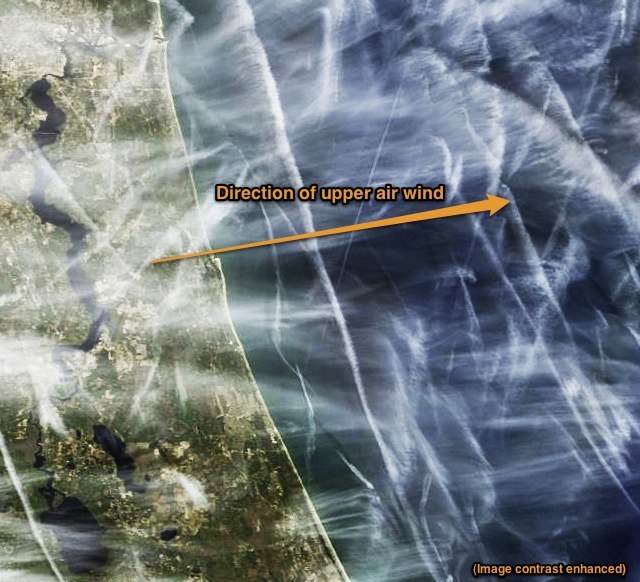
Thanks for the DAB info. Note that some of our best contrail days over the peninsula are when the subtropical jet stream is vigorous and trails are rapidly advected from west to east. I'm 25 mile inland of DAB. Trails laid over the Tampa area by flights between Miami and Houston (busy route) area visible in the western sky and will pass overhead within 90 minutes while trails created overhead will pass off shore quickly.
To me this data highlights just how much air traffic there is- traffic that most people are probably oblivious too...and how easy it would be, if conditions permit, to create a grid of contrails.
TreasureCoast- I am curious, have your opinions regarding "chemtrails" changed at all since you have participated in this forum? Am I correct in recalling that you were very convinced of some type of spray campaign at one point? Didn't you participate at AirCrap.org at times? or was that someone else?
Thanks for the DAB info. Note that some of our best contrail days over the peninsula are when the subtropical jet stream is vigorous and trails are rapidly advected from west to east.
To me this data highlights just how much air traffic there is- traffic that most people are probably oblivious too...and how easy it would be, if conditions permit, to create a grid of contrails.
TreasureCoast- I am curious, have your opinions regarding "chemtrails" changed at all since you have participated in this forum? Am I correct in recalling that you were very convinced of some type of spray campaign at one point? Didn't you participate at AirCrap.org at times? or was that someone else?
My opinions have changed slightly . Iv look into both chemtrails and geoengineering and always tried to stick with the geoengineering aspect only. The fact that there are trails over the Whitehouse would lead me to belive that there isnt threat to my health at the time . That would rule out all the diseases and sicknesses that would come with spraying . They are persistant ugly contarils and the only health threat to me is my daily dose of Vitamin D . Iv always tried to stick with facts and consider my self a skywatcher not a chemtrailer . I like when I am engaged with facts on this site . Insults which I do get from time to time on this site however are counter productive . Mick has always been civil and engages with science and facts . When others learn to do the same it would only help the cause . In the end if I find out that it has always been like this and my skies will always look like crap . I will stop looking up .
My opinions have changed slightly . Iv look into both chemtrails and geoengineering and always tried to stick with the geoengineering aspect only. The fact that there are trails over the Whitehouse would lead me to belive that there isnt threat to my health at the time . That would rule out all the diseases and sicknesses that would come with spraying . They are persistant ugly contarils and the only health threat to me is my daily dose of Vitamin D . Iv always tried to stick with facts and consider my self a skywatcher not a chemtrailer . I like when I am engaged with facts on this site . Insults which I do get from time to time on this site however are counter productive . Mick has always been civil and engages with science and facts . When others learn to do the same it would only help the cause . In the end if I find out that it has always been like this and my skies will always look like crap . I will stop looking up .
IMO there is no reason to have so much crap in the sky . . . a 2 - 3% increase in fuel costs on persistent contrail optimal days would dramatically reduce their frequency . . .
28TH INTERNATIONAL CONGRESS OF THE AERONAUTICAL SCIENCES
UNCERTAINTY QUANTIFICATION IN THE DEVELOPMENT OF AVIATION OPERATIONS TO REDUCE AVIATION EMISSIONS AND CONTRAILS
Banavar Sridhar*, Neil Chen*, Hok K. Ng**
*NASA Ames Research Center, Moffett Field, CA 94035-1000
**University of California, Santa Cruz@Moffet Field Keywords: Aviation operations, Environmental impact,
Simulation and optimization, Contrails, Models
. A 2-3% additional fuel usage reduces the surface temperature change to its lowest value. Any reduction in contrails beyond this point is negated by the increase in CO2 emissions. The results suggest that to limit the amount of excess fuel usage while minimizing the environmental impact of aviation operations, it is cost-beneficial to limit contrail reduction maneuvers to days with medium or high amount of contrail formation.
IMO there is no reason to have so much crap in the sky . . . a 2 - 3% increase in fuel costs on persistent contrail optimal days would dramatically reduce their frequency . . .
UNCERTAINTY QUANTIFICATION IN THE DEVELOPMENT OF AVIATION OPERATIONS TO REDUCE AVIATION EMISSIONS AND CONTRAILS
Banavar Sridhar*, Neil Chen*, Hok K. Ng**
*NASA Ames Research Center, Moffett Field, CA 94035-1000
**University of California, Santa Cruz@Moffet Field Keywords: Aviation operations, Environmental impact,
Simulation and optimization, Contrails, Models
. A 2-3% additional fuel usage reduces the surface temperature change to its lowest value. Any reduction in contrails beyond this point is negated by the increase in CO2 emissions. The results suggest that to limit the amount of excess fuel usage while minimizing the environmental impact of aviation operations, it is cost-beneficial to limit contrail reduction maneuvers to days with medium or high amount of contrail formation.
Id have to agree . Could it just be theyve changed the fuel so that there are persistant contarils ? I remember living near LAX as a kid (1972) how you could see the blackness coming out of the jet engines as they landed along the 405 freeway . They seemed to get cleaner over the years . But i still dont remember Contrails everywhere even then . Did they remove sulphur like they did in diesel fuel only to add it later again ?
I came upon this study and find it interesting . . . the research indicates that Cirrus Cloud reductions (through a type of high tropospheric cloud seeding) could result in slowing global warming and that commercial aviation could be the easiest and cheapest way to accomplish such geoengineering without much of the side effects of sulfur injection for example . . . the amount of cloud seeding material would be small in comparison to the sulfur injected into the stratosphere . . .
Modification of cirrus clouds to reduce global warming
David L Mitchell and WilliamFinnegan
Desert Research Institute, Reno, NV89512-1095, USA
E-mail: david.mitchell@dri.edu
Received 1 April 2009
Accepted 12 August 2009
Published 30 October 2009
Abstract. Greenhouse gases and cirrus clouds regulate outgoing longwave radiation (OLR) and cirrus cloud coverage is predicted to be sensitive to the ice fall speed which depends on ice crystal size. The higher the cirrus, the greater their impact is on OLR. Thus by changing ice crystal size in the coldest cirrus, OLR and climate might be modified. Fortunately the coldest cirrus have the highest ice supersaturation due to the dominance of homogeneous freezing nucleation. Seeding such cirrus with very efficient heterogeneous ice nuclei should produce larger ice crystals due to vapor competition effects, thus increasing OLR and surface cooling. Preliminary estimates of this global net cloud forcing are more negative than–2.8 W m–2 and could neutralize the radiative forcing due to a CO2 doubling (3.7 W m–2). A potential delivery mechanism for the seeding material is already in place: the airline industry. Since seeding aerosol residence times in the troposphere are relatively short, the climate might return to its normal state within months after stopping the geoengineering experiment. The main known drawback to this approach is that it would not stop ocean acidification. It does not have many of the drawbacks that stratospheric injection of sulfur species has. http://m.iopscience.iop.org/1748-9326/4/4/045102/fulltext/
Id have to agree . Could it just be theyve changed the fuel so that there are persistant contarils ? I remember living near LAX as a kid (1972) how you could see the blackness coming out of the jet engines as they landed along the 405 freeway . They seemed to get cleaner over the years . But i still dont remember Contrails everywhere even then . Did they remove sulphur like they did in diesel fuel only to add it later again ?
The fuel is pretty much the same. The higher efficiency engines create more contrails because of the cooler exhaust. The biggest factor of course is the increase in flyover traffic. None of the local LAX traffic would have made contrails in 1972, but now there's a lot more North-South traffic over LAX for San Diego and Mexico.
We still get very few contrails in Los Angeles (I'm just 4 miles for LAX, so, again, get no contrails from LAX traffic). Contrail season picks up when the rains do.
Id have to agree . Could it just be theyve changed the fuel so that there are persistant contarils ? I remember living near LAX as a kid (1972) how you could see the blackness coming out of the jet engines as they landed along the 405 freeway . They seemed to get cleaner over the years . But i still dont remember Contrails everywhere even then . Did they remove sulphur like they did in diesel fuel only to add it later again ?
Persistence is caused by a few factors since the 1970s
1) More efficient and larger engines
2) Increased number and frequency of air traffic above 30,000 feet where air is more optimal for persistence
IMO there is no reason to have so much crap in the sky . . . a 2 - 3% increase in fuel costs on persistent contrail optimal days would dramatically reduce their frequency . . .
A small groupe around a german researcher named Prof. Peter Spichtinger trying to make these ideas popular - he often mentioned that flexible flight-ranges could sink the rate of contrails.
suddenly, most of his work is only available in german.
The paper I´d read was "Spichtinger, P., 2004: Eisübersättigte Regionen. DLR-Forschungsbericht FB-2004-21, pp. 211. (PhD Thesis)"
There is also a radio-podcast in english from him:
Last month I spoke with Dr. Peter Spichtinger at the ETH in Zurich about his work studying cirrus clouds in the upper atmosphere and the need for more complete cloud models:
Persistence is caused by a few factors since the 1970s
1) More efficient and larger engines
2) Increased number and frequency of air traffic above 30,000 feet where air is more optimal for persistence
"More efficient and larger engines" is not a cause of contrail persistence.
Also, the air above 30,000 feet is no more "optimal for persistence" than the air below 30,000 feet. Where did you read that?
Perhaps you had better re-think and clarify your statements.
On persistent contrail mitigation, I have seen research that says that a change in altitude of 1000 feet will get you out of the ice-supersaturated layer on most occasions that you find your self in one - or something like that. I will find the reference and post it.
Another point why more contrails are seen is, that smaller commercial airlines are using more Jets instead of propeller-driven airliner. Actually most European Airlines replacing their Probs with modern Jets a planespotter sayed me.
IMO there is no reason to have so much crap in the sky . . . a 2 - 3% increase in fuel costs on persistent contrail optimal days would dramatically reduce their frequency . . .
It would be nice to think airlines would consider this however this article published in the London Guardian reveals that British Airways were spending 7 million GBP per day on fuel. ( 11,300,000 USD per day)
So with a 50 million pound fuel bill per week 2% would be another million per week in extra costs wouldn’t it.
This then means George that you the passenger may have to pay an extra £50 on the airline ticket which we assume you are quite OK about.
Dissipation of contrails with a powerful microwave beam aligned behind aircraft engines is being touted as a possible solution to help address air transport's effects on the climate.
Speaking on 19 November at the Towards Sustainable Aviation Propulsion event organised by the Institution of Mechanical Engineers, Cranfield University's Frank Noppel described how his research led sponsor Rolls-Royce to file a patent on what he believes could be a cost-effective contrail avoidance technology.
Noppel told delegates that ice particles could be prevented from forming, or be evaporated once formed, by remotely heating them, together with condensation nuclei such as soot in the exhaust plume.
Contrails form as the engine exhaust mixes with ambient air, the temperature drops and humidity levels reach super-saturation, leading to the formation of ice particles. Contrails are also more likely to form as a result of increasingly-efficient engine architecture.
An influential Intergovernmental Panel on Climate Change special report in 1999 on aviation and the global atmosphere attributed the second-largest climate effect of aviation-specific emissions to linear - or young - contrails, with contrail cirrus thought to have an even more significant effect.
"The remote heating of condensation nuclei could be achieved by applying electromagnetic radiation, such as microwaves," says Noppel. "Depending on assumptions made, calculation shows that the power required for such a device could be as little as 0.1% of the engine power."
"With theoretically low energy requirements and associated weight penalty, existing aircraft could possibly be retrofitted and new aircraft equipped with this technology," he adds.
Speaking at the same event, German aerospace centre DLR's Klaus Gierens agreed that manipulating the contrail composition of, for example, the number and size of emitted soot particles could produce fewer ice crystals - making the contrail optically thinner and reducing its lifespan.
"More efficient and larger engines" is not a cause of contrail persistence.
Also, the air above 30,000 feet is no more "optimal for persistence" than the air below 30,000 feet. Where did you read that?
Perhaps you had better re-think and clarify your statements.
On persistent contrail mitigation, I have seen research that says that a change in altitude of 1000 feet will get you out of the ice-supersaturated layer on most occasions that you find your self in one - or something like that. I will find the reference and post it.
I think you will find that more efficient engines have cooler exhaust which lead to higher Relative Humidity of the plume and greater chance of persistence in optimal air; the air above 30,000 has a higher liklyhood of being below -40 C and is above where most long haul aviation cruises . . .
I think you will find that more efficient engines have cooler exhaust which lead to higher Relative Humidity of the plume and greater chance of persistence in optimal air; the air above 30,000 has a higher liklyhood of being below -40 C and is above where most long haul aviation cruises . . .
It does not actually make a contrail more likely to persist, as that depends on the ambient air temp and humidity. It DOES make it more likely to be created in the first place, so it will increase the number of contrails, both short and persistent.
Persistence is caused by a few factors since the 1970s
1) More efficient and larger engines
2) Increased number and frequency of air traffic above 30,000 feet where air is more optimal for persistence
Well Fred . . . I think your estimate is way over the top for the following reasons . . . world wide persistent contrail optimal air (supersaturation for ice) is (if my memory is correct) 15 - 17% at cruising altitudes . . . one need only alter altitude or vector on those days . . . of course the UK may have more optimal days than say Spain for example . . . and you are so correct about fuel costs . . . it would be a universal burden all effected equally . . . and my gasoline costs vary more than 1-2% percent in one week . . . so no sympathy their either . . . LoL!!!!
This then means George that you the passenger may have to pay an extra £50 on the airline ticket which we assume you are quite OK about.
You'd also need to spend a few hundred million dollars on getting the system up and running, and then millions yearly in operating costs. Nobody want to pay that, so nobody is going to do it. Especially when the benefits are so uncertain.

") .
.