Sources of EMF Readings at Skinwalker Ranch

Mick West

Administrator
Staff member
Skinwalker Ranch is popular both in the UFO and the Paranormal communities as a place where supposed strange things happen - things that might be attributed to ghosts, aliens, tran-dimensional beings, or just something in the geology.

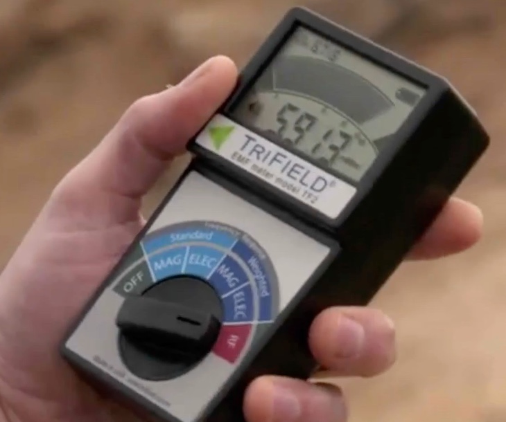
None of this is backed up by hard science, but one thing that is rolled out with some frequency is the presence of supposedly anomalous readings of EMF radiation. This comes up often in the History Channel's show The Secret of Skinwalker Ranch where they use a Trifield brand RF meter to show a variety of random readings.


About 25 minutes into Season 1, Episode 1, Travis Taylor says:
Out on the Mesa we are using the electrical field measurement devices called TriField meters ... and they measure three fields: magnetic field, static electric field, then it measures radio frequency and microwave which is an electromagnetic dynamic field ... There are always electromagnetic waves and microwaves bouncing around everywhere, we use that for WiFi, your cellphone communication, everything. The biggest thing that piqued my interest was the amount of energy in these microwaves measured was getting close to dangerous levels ... and the direction continued to change.
...
Skinwalker ranch is in the middle of nowhere and I couldn't see a cellphone tower as far as I could see. I barely was getting a signal on my phone. And there were no WiFi routers.
...
We went to the top of the mesa, what we found was , even more, the electromagnetic radiation that shouldn't be there. And at dangerous levels that could be harmful to humans.
...
The levels of microwaves that that we detected were much stronger than you get from your cellphone or your WiFi routers. Microwaves like that just don't exist in nature. So, where was this microwave radiation coming from? Because I've never seen it.
Content from External Source
Metabunk 2020-04-12 08-20-35.jpg
The highest reading I saw was 18.919 mW/m2. Current WHO exposure limits are 9,000 mW/m2.

So, where might this radiation be coming from? There's a number of possible sources to consider
  1. Their own cell-phones
  2. Wireless microphones (they are all wired for sound with lavalier microphones )
  3. Walkie-talkies
  4. Nearby radio stations
  5. Nearby airports (and airplanes)
  6. Nearby cell-phone towers
For 1 & 2, here's a shot of Travis with a cell phone and a wireless microphone transmitter (note the wires and antenna poking out)
Metabunk 2020-04-12 08-50-38.jpg

The closest radio station is KNEU, 4 miles away. broadcasting at 1250kHz, kw. 88 meter antenna. https://www.fccinfo.com/CMDProEngin...bSearchType=Appl&sAppIDNumber=310936&sHours=D
KNEUtower.jpg

There are a few airports. The closest is Roosevelt, 8.5 miles away, and a larger one at Vernal, but that's 23 miles away. (airports will be important for other things too, like lights in the sky)

The closest cell-phone towers I could find were two about 3 miles away to the north on Rt 40/Hwy 191
Metabunk 2020-04-12 09-55-49.jpg

Metabunk 2020-04-12 09-20-08.jpg

There does not seem to be a direct line of sight to these antennae from the location on the mesa where they were doing their readings, which has a viewshed mostly to the south.
Metabunk 2020-04-12 10-03-59.jpg

Any other suggestions?
 
Last edited:
In the U.S., the maximum RF output power for wireless microphones is limited to 250 mW.
Content from External Source
https://www.prosoundweb.com/understanding-wireless-rf-output-power/

CellphonePower.png
http://www.mobileworld.org/gsm_about_06.html
I would expect the phone to use a high output power level especially when the reception is bad; if you compared it to what it uses normally, it could be a lot more. The cellphone would send particularly strongly if there are no cell towers nearby, and if it had an internet connection, might be active without the user being aware.

The maximum legal CB power output level in the U.S. is 4 watts for AM (un-modulated carrier; modulation can be four times the carrier power, or 16 watts PEP) and 12 watts for SSB, as measured at the transmitter antenna connection
Content from External Source
https://en.wikipedia.org/wiki/Citizens_band_radio#Current_use
Though you'd hope they'd notice if one of the crew is using their walkie-talkie while they're taking measurements.

I don't think any external transmitters matter, the distance should attenuate the signal a lot. As you know, these transmitters are already at safe levels when you are nearby, and then diminish with the square of distance.
 
In the U.S., the maximum RF output power for wireless microphones is limited to 250 mW.
Content from External Source
https://www.prosoundweb.com/understanding-wireless-rf-output-power/

So what would this actually result in? I'd imagine it's more complicated, but let's say that's the maximum 250 mW at the antenna, then at a distance that has a surface area of 1 square meter, would that measure 250 mW/m2?

Sphere area formula = 4πr^2
Radius for and area of 1m2 = sqrt(1/(4π)) = 0.28m

At one meter away, about 3 feet, the surface area is 4πr^2, or about 12.5.

The maximum power of a lav mic transmitter is 250mW, so at 1 meter that would be 20mW/m2, which is the maximum reading on the meter.

However it seems like 50mW is the most you can do without a license. A simple surface area reduction to 20mW would happen at sqrt(20/50/4/π) = 0.18m (0.6 feet)
 
I don't think any external transmitters matter, the distance should attenuate the signal a lot. As you know, these transmitters are already at safe levels when you are nearby, and then diminish with the square of the distance.
For a ballpark, let's take KNEU, 4 miles away 5kW nondirection. A 4 mile radius sphere has a surface area of 4*π*4828^2 square meters

So power in mw = 5000000/(4*π*4828^2) = 0.017mW/m2

So yeah, that does not seem like something that would be a factor here.
 
Radar Altimeter
On a commercial aircraft, the radar altimeter sends predominantly straight down.
Radio altimeter transmitter power levels range from 40 milliwatts to 5 watts. Some pulsed radio altimeters used for Federal research and development programs (e.g., missile testing) have peak power levels between 100 to 500 watts; however, they are restricted to operating in specific geographic areas (e.g., 100 kilometer radius around a military base). The transmit and receive antennas are broad-beamed downward looking with a nominal gain of approximately 10 dBi to allow the operation of the radio altimeter at moderate pitch and bank angles of the aircraft.
Content from External Source
https://www.ntia.doc.gov/files/ntia/publications/compendium/4200.00-4400.00_01MAR14.pdf
The gain of 10 dBi is a property of the the antenna systems and means the radiated power in the main direction (down) is 10dB more (times 10) than the power for a theoretical isotropic antenna (generating a uniform spherical field), like the one you assumed in your computation above.
However, due to planes being fast and helicopters being loud, such an influence should be either transient or very noticeable.

For the wireless microphone transmitter, antenna gain plays a role as well, as does the fact that the body shields the back pocket from the radiation meter. Reflections could cause changes as they move around. Is the Trifield operator the only person wired for sound? Do they use a drone?
I did try to find the actual power of these systems, but the spec sheets I saw didn't have that information.
 
For the wireless microphone transmitter, antenna gain plays a role as well, as does the fact that the body shields the back pocket from the radiation meter. Reflections could cause changes as they move around. Is the Trifield operator the only person wired for sound?
I did try to find the actual power of these systems, but the spec sheets I saw didn't have that information.
They seem to commonly be in power setting of 50, 100, and 250mw, and the more professional models are switchable between the levels. Example:
https://www.performanceaudio.com/le...ck-transmitter-block-470-470-1-495-6-mhz.html
Metabunk 2020-04-13 10-39-27.jpg
selectable output power of 100 or 250 mW. A third selection at 50 mW is provided for some theatrical applications
Content from External Source
Note the antenna here seems somewhat similar to Taylor's.
Metabunk 2020-04-13 10-47-32.jpg
 
While it's unlikely to be an issue, I think it's worth pointing out the long-distance power-lines that run just under a mile to the north in an east-west direction. You can see them in this drone shot
Metabunk 2020-04-13 11-01-28.jpg
Metabunk 2020-04-13 11-12-55.jpg
Metabunk 2020-04-13 11-11-28.jpg

They make some EMF, but probably not a mile away?
 
ADS-B
The ES ADS-B message is a 120 bit transmission that contains the aircraft identification, position, velocity, and status. The message is broadcast with a period that ranges randomly between 0.4 and 0.6 seconds. This randomization function is designed to prevent aircraft from having synchronized transmissions on the same frequency, and thus obscuring each other's transmissions. Required transmitter power for the ADS-B signal varies with the aircraft category. For smaller aircraft, a minimum transmission power of 75 W is specified while larger aircraft require a minimum power of 125 W or 200 W with a maximum output power for all classes of 500 W [6]. Any aircraft that is capable of operating at altitudes greater than 15,000 ft (4570 m) above sea level (ASL), or with cruising speeds above 175 kts (324 km/h), are required to transmit at 125 W as a minimum [6]. Aircraft use a quarter-wave monopole antenna for ADS-B transmissions that transmit vertically polarized signals.
Content from External Source
https://www.hindawi.com/journals/ijno/2011/973656/
Because the antenna is mounted vertically, the radiation is directed mostly sideways and not straight down.

I looked for airports nearby; the closest is a Navajo airstrip that I couldn't actually recognize on Google Earth; all other airports are more than 10 miles away. That should rule out aircraft being nearby routinely.wrong state
 
Last edited:
When people are passing directly below a high voltage powerline, they can be exposed to an electric field between 2 to 5 kV/m and to magnetic fields of less than 40 µT. The strength of the electric and magnetic field diminishes rapidly with distance to the line.

Low voltage power lines cause much lower exposure (100-400 V/m and 0.5-3 µT), and buried cables virtually none. Power plants and distribution stations are off limits to most people and so are not considered a source of exposure for the general public. The same goes for railway power supply installations. The exposure levels in the areas that are accessible to the public are below the set limits.
Content from External Source
https://ec.europa.eu/health/scienti...romagnetic-fields07/l-2/7-power-lines-elf.htm
The issue with these is that the wavelength is on the order of 3000 miles -- a handheld device or the human body is a very ineffective antenna for this kind of radiation (as is the powerline).
 
Season 1, Episode 2, about 15 minutes in


Metabunk 2020-04-13 11-31-14.jpg

Metabunk 2020-04-13 11-30-46.jpgMetabunk 2020-04-13 11-39-19.jpg
The meter shows 1385.080 - but perhaps that's just editing (audio and video are often different with close-ups)

https://www.ntia.doc.gov/files/ntia/publications/compendium/1240.00-1300.00_01MAR14.pdf

The band 1240-1300 MHz is used by Federal agencies for operating various types of
long-range radar systems that perform missions critical to safe and reliable air traffic
control (ATC) in the national airspace, border surveillance, early warning missile
detection, and drug interdiction.
Content from External Source
So possibly a blip from being swept by ATC radar.
 
In Episode 3 they are seen with what looks like a wireless weather station. Metabunk 2020-04-15 08-35-48.jpg

The weather station itself is an Ambient Weather WS-2902A Osprey, which uses a 915Mhz connection to the base station. 300 foot range.
Metabunk 2020-04-15 08-50-31.jpg

Then there's a white dome next to this with an antenna. I don't know what this is. Maybe a WiFi extender.


Metabunk 2020-04-15 09-15-27.jpg
Later they take so readings of mysterious RF, quite close to this transmitter. This might account for some of their readings
Metabunk 2020-04-15 08-39-28.jpg
 
Last edited:
Camera operators working in difficult areas like this, would likely be equipped with an additional 1 or 2 transmitting signals.

One would be an separate audio intercom directly to the director and producers sitting at a nearby "base camp", wearing headsets..
Another transmission would be a wireless video signal from the camera(s) to the base camp video monitors.... so the recorded footage can be viewed "live" ...and where extremely long cables are not practical.

Systems like this.....
https://www.filmtools.com/cameradep...mo-600-wireless-hdmi-sdi-system-l-series.html
 
Last edited:
Another possible source is the Wifi cameras and access point set up on the cattle pen used to lure trans-dimensional werewolves.
Location of tower near pad.jpgCameras on tower wifi annotated.jpg
 
I bought a TriField TF2, and after some short experimenting, I think the most likely source of the RF is something very local to them as I suggested in the first post.

At my house, anywhere more than ten feet away from a WiFi hotspot gives a reading of less than 0.100, and outdoors this rapidly drops down to 0.002 or lower. My phone was in full airplane mode for the photos.

The highest reading at a spot away from the house I could find (without going for a drive) was 3 miles away from a cellphone tower. 0.030 mW/m2Metabunk 2020-04-25 16-07-02.jpg

My smart meter had momentary peaks above 20, but basically broadcast at 0.5 (1 foot away) for a second every minute.
Metabunk 2020-04-25 16-08-37.jpg

Highest readings were from my 4G-LTE hotspot antennas. 16 at about 2 feet
Metabunk 2020-04-25 16-10-27.jpg

I was also above to get reading around 10 with my iPhone on a skype video call, at about 2 feet.

Metabunk 2020-04-25 16-16-02.jpg

So I'd go with wireless microphones as the #1 possible source here.
 
So I'd go with wireless microphones as the #1 possible source here.
I'm curious how much your phone gives off if you use it in an area with poor reception, when it adapts the signal strength to compensate. Maybe something to try when not sheltering-in-place.
 
I'm curious how much your phone gives off if you use it in an area with poor reception, when it adapts the signal strength to compensate. Maybe something to try when not sheltering-in-place.
I tried experimenting with inside vs. outside - where outside normally give significantly better reception. I put my phone and the meter in a box to maintain constant spacing, with my phone on a Skype video call.
Metabunk 2020-04-25 22-14-28.jpg

Indoors it seems very high at 14.5+. I took it outside and it dropped to 1.3
Metabunk 2020-04-25 22-15-42.jpg

But then I came back inside, and it was just as low!

So it seems there are multiple factors at play.
 
Just an engineering thought or two from left-field. I read they have had an intruder problem there. I wondered is it possible that someone previously installed a microwave motion detector system there in the past? Kind of thing you could bury and run on a solar panel - which can be hidden. The commercial parts run on 5GHz / 1mW. If they were networked and concealed it would be easy to unknowingly walk into a grid and get a high radiation level also various nodes would pop up as it mesh networks its way back to some central receiver node. If this site ever had military security on it there is military tech that mesh networks exactly like that - ditto stealth microphones and vibration detectors. The folks who try to walk through the outer perimeter of military bases usually get caught by them. Further to all of that there is military security and detection tech known as 'mote networks' that is basically smart dust. Imagine a cluster bomb spitting out sensors over a few acres from 30,000 feet. The battery-less sensors mesh network to each other when triggered until they eventually jump to a larger TX/RX node and get a message out. There are audio, vibration and wavelength detectors so I hear. This is not particularly secret - the solid state battery company that powered the DARPA project is now a corporation selling the developed battery-like technology into ultra low power sensors. The systems rely on ultra slow communication and jumps of a few feet - therefore needing tiny amounts of power. I don't know the center frequency but if you could see the radio waves as you walked through smart dust your footsteps would create something like ripples on water as the trigger rippled from nearby receiver to receiver - this might indeed give a detected signal that changed direction erratically. Also on the subject of microwaves, these sensors can energy harvest - heat light and vibration. Microwaves are a ready way to supply power to energy harvesting systems. It might even be then that some system is charging its phone - like a massive wireless phone charger. I have a system in my home here that will charge a small battery from my Wifi signal (or my neighbor's) - if you wait long enough. If I was a military observer on a team charged with monitoring this space for strange events then all the tech mentioned above is things that I would probably spend my budget on. I am not military and none of the above is secret to the best of my knowledge. I am an engineer and all info I glean is by talking to corporations at electronics tradeshows. All real and all at least 15 years out of date I hasten to add. JC
 
Re: anomalous EM readings and phenomena at Skinwalker Ranch and area, it is perhaps interesting that the recent television show "Mystery At Blind Frog Ranch" - located in the same area - reports similar anomalies. A recent episode of of that show, indicated unusual ground-penetrating radar results at the site. Furthermore, the owner was able to smelt metallic objects from the topsoil.

XRF gun readings of that soil found a reading of "804,000" [units?], which was represented as being very highly elevated.

Mystery At 'Blind Frog Ranch’ ... Huge Rare Iridium Discovery
 
Last edited:
I looked for land for sale near this "Skinwalker Ranch" TV show mystery.
I found some, about 10 acres "near Skinwalker".
( https://www.landandfarm.com/property/South_Fork_Uintah_UT-14690176/ )
ABOUT THE PROPERTY:
10 acres located near Ballard, Utah in Uintah County. This property has 2 track dirt road access, and is flat so you can pull your RV up easily. Camping is allowed up to 16 days! This would make the perfect property for someone looking to get away from town for a long weekend or a few weeks, or that van lifer who needs a spot to crash for a few days while they explore beautiful Utah! Bring all your off grid toys, dirt bikes, ATVs, and ride all around this property. No neighbors means extreme privacy and flexible zoning allows for building, manufactured homes and RV camping.

....and some abilities to shoot lights in the sky, and scare people.
 
Last edited:
I believe the EMF that's being detected out in the field, the "triangle", the 2nd homestead, is due to the single-phase and neutral power lines that run through several of the pastures and at the "triangle" alongside the dirt road. The power lines appear to start at the road 4500 E by the campground, and through the ranch to the main building that's at the end of road with the no trespassing signs (E 3000 S), though it's possible that they might alternately be energized from a buried power cable on E 3000 S to the main building, but I consider that unlikely.

I was able to find several views that shows the power lines running across the property in the locations mentioned.

The first shows the power lines running through the pasture from a viewpoint that geolocated near the cattle pens by the main building.
Teaser Screencap showing the powerlines viewed through a gate with the Skinwalker ranch logo, with the mesa in the background.
Geolocation of above image in Google Earth, the approximate coordinates of the camera are 40 degrees, 15 minutes, 31.61 seconds north by 109 degrees, 53 minutes, 20.75 seconds west.

A clearer view of the same power lines.
View from a ranch security camera, providing a clearer view of the same powerlines.

The power lines running towards the second homestead. (Might be hard to see the actual lines in this one due to compression.)
View from a security camera showing the powerlines running towards the second homestead at dusk.

Geolocating where this security camera and the power poles are located was a bit difficult, until I realized the camera likely had a zoom lens. My best guess is that it was taken from a security camera located on top of the observation stand in the "bait pen" east of the second homestead looking west.
Geolocation of the security camera image in Google Earth, with the approximate location for the zoomed camera image marked. The approximate position of the security camera is 40 degrees, 15 minutes, 21.74 seconds north by 109 degrees, 53 minutes, 58.75 seconds west.

I haven't been able to spot any power lines running to the elevated stands in the "bait pens", but given the amount of equipment they have and the apparent lack of solar panels, I suspect the ones with equipment are powered via a buried cable from the closest utility pole.
 
Back
Top