• MH370 speculation has become excessive recently. Metabunk is not a forum for creating theories by speculation. It's a forum for examining claims, and seeing if they hold up. Please respect this and keep threads on-topic. There are many other forums where speculation is welcome.

MH370 Preliminary Report Released - Full Text and Files

I did find this about US spy satellites. http://www.hermetic.ch/crypto/echelon/sat.htm. The program started in putting satellites into orbit in 2005, so I have no idea where they are at with this project or if the project even went into action. But if they have the capability of getting eyes on any target in the world within a few hours thats pretty remarkable.
Anyone wondering where U.S. military investment is headed need look no farther than the next generation of spy satellites that are being built now and will start going into orbit in 2005.

The estimated 20-year price tag is $25 billion, making this program the most expensive venture ever mounted by U.S. intelligence services. In comparison, the Manhattan project, the World War II crash program to build the atomic bomb, cost $20 billion in inflation-adjusted dollars.

In the planned new system, the U.S. space-based cameras will collect from eight to 20 times more imagery than the present array, according to people at the Federation of American Scientists, a Washington-based group with access to some aspects of the secretive program. While performance details are classified, experts said that the modernized, miniaturized satellites would be able to identify objects one-tenth the size of those visible in commercially available satellite pictures.
Content from External Source
The truly revolutionary feature, however, is not in the sky but in the ground station computers that will capture the downloads of electronic imagery, process the data into usable intelligence and then distribute pictures to a growing throng of U.S. government agencies — the official consumers for the material. "Where the loop used to involve a half-dozen players, there are now scores of offices that want to put in orders for satellitecoverage and then get the data back fast, and all this traffic to be prioritized and the material processed," Mr. Pike said.
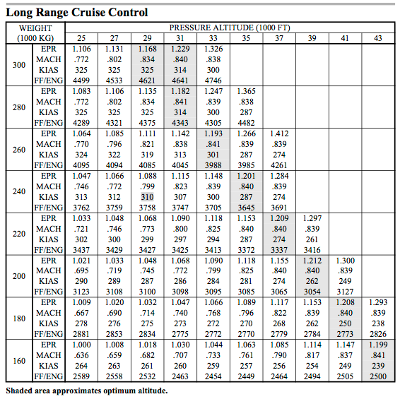
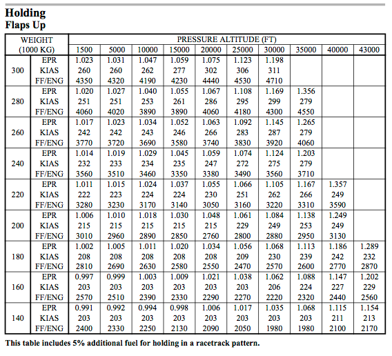
Content from External Source
 
No Landru, I have cited what I know and what I have read in good faith. I am not Superman.

It seems to me that if an Attorney at the US Bar publicly cites a public TV broadcast, then that would be the equivalent of a notarised statement and acceptable in a court of law. You seem to be placing the bar for evidence higher than a court would.

No, it doesnt.

Affidavit Definition
  • As West's Encyclopedia of Law states, an affidavit is "any written document in which the signer swears under oath ... that the statements in the document are true."
Notarized Statement (Affidavit) Definition
  • A "notarized" statement occurs 1.) when an affidavit is presented to a notary public and the affiant (the individual requesting notarization) swears under oath the facts contained are true; 2.) when other documents, such as employment identity verification forms, are notarized. Geographically distant employers may request notarized documents to verify employment eligibility.
Content from External Source
Citing a broadcast amounts to opinion and nothing more. As was pointed out, itd be no different than you walking into court and saying "Yes your Honor, I know there was a second gunman on the grassy knoll because Walter Cronkite was on the news last night and said he saw the guy." Itd get bounced out of court in a heartbeat. Scientifically backed facts, and not editorial/opinion, on the other hand would be accepted because it can/has been verified multiple times including peer review. Which is part of the reason it took decades to get DNA allowed as evidence in court.
 
Simon, the list of your poorly sourced/not credible/fictional leads is growing. For anyone to take you seriously, I feel you need to step back and verify that everything you use is reported by at least two independent, credible sources.

Now, you probably don't trust the Malaysian govt to be 100% forthcoming and I agree with you on that, but quoting beforeitnews in support of these theories doesn't help anyone's credibility.

With the exception of #56, whose observations (excluding the IGARI-VAMPI-GIVAL-IGREX quibble) I support, I agree the thread is beginning to dip too deeply into the gloriously slippery world of "internet truth".

Which brings me back to my (admittedly pet) theory.

While I feel I've proven beyond reasonable doubt - with reference only to uncontroversial data, and corroborated by pure logic - that the March 28 ATSB release contains a rationale diametrically at odds with its conclusions, I had hoped that a pilot or two might have by now taken up my challenge (#45), and either proven or disproven my theory by simulation.

This would have helped provide those who care about closure for victims' families a means by which to hold the Australian government accountable (which I consider a better approach than attempting the same feat with the Malaysian government), by forcing a bit more of the truth out into the public domain. Actual truth.

Oh, well.
 
A simulation requires the altitude/selected speed of the aircraft to be known and the performance data for the aircraft to be handy.

The second can probably be found somewhere on the net but it is useless without knowing the altitude/speed the aircraft was flying.

You can build a theoretical case using 5000 foot increases in altitude, but it won't be definitive without these inputs.

The DFDR needs to be found. It will answer all those questions.

#56 stipulated both a speed and altitude. To your point: I reconfirm this simulation test should be attempted at various speeds/altitudes, to test sensitivity.

Not given up on.
 
You don't need a simulator, just the performance data. If you can find it, I'll give it a go.

Huge thanks, TWC.

I'm not a pilot. To guide my search, which of these is closest in content (ignoring model) to what you need?

http://www.scribd.com/doc/210896551/BOEING-767-Airplane-Flight-Manual (what WW provided me)
http://www.allbookez.com/pdf/15xcxm/
http://www.performance737.com/
http://www.deltava.org/library/B777 Manual.pdf
http://www.airliners.net/aircraft-data/stats.main?id=106 (1-pager of key dimensions/performance stats)
http://www.boeing.com/assets/pdf/commercial/airports/acaps/7772sec3.pdf (Section 3 (performance) of Boeing's "detailed tech specs)
http://www.boeing.com/assets/pdf/commercial/startup/pdf/777_perf.pdf

I've contacted a pilot (Edward Baker) described in Duncan Steel's blog as having tested endurance at various speeds (and having reached conclusions similar to mine: no net endurance savings at 325 KTAS) - if he gets back to me, we may be in business.

I also found a pdf of a study which summarized altitude/speed data for hundreds of 200ER flights into scatter plots - can't find it today. Very interesting to me ("highest probability path" was an outlier on those plots), but not likely helpful to you.
 
I have a 777 pilot friend who is sending me the data for the RR powered -200. It is not the ER version but it should be close enough.
 
I have a 777 pilot friend who is sending me the data for the RR powered -200. It is not the ER version but it should be close enough.
Awesome - profuse thanks.

One more feeble attempt to help - my pilot did get back to me, but was traveling. Referred me to "posted pics" of the perf data - found a set captioned "Trent892" - the LRC and Holding tables of which are:


Closer? (academic, at this point, if your friend comes through.)
 
One more feeble attempt to help - my pilot did get back to me, but was traveling. Referred me to "posted pics" of the perf data - found a set captioned "Trent892" - the LRC and Holding tables of which are: {snipped images, to avoid clutter}

I'd say you have gold there. As long as you know how to interpret them? At least you can see all of the variables....LRC charts are only compiled at normally expected cruising flight levels of course.

The Holding chart gives you a wider altitude range, but those recommended weight/speed/altitude numbers (Flaps Up) are specifically suited for....well, holding patterns. Not for someone who wants to "Get There" as fast as possible at, say, 5,000 feet (and, doubting whether you'll find those types of burn charts). These sorts of charts are specific to normal airline operational performance planning.
 
Well, thanks to this site, I at least know what the acronyms mean - and should be able to convert from KIAS to KTAS. Three questions:

1) the weight is still unknown, but I've seen estimates of 223.5K kg, including fuel (which itself I've seen listed at 49.1K kg) at TO. Nowhere in the 180-220K kg weight range do I see 30,000 feet at anywhere near as slow as 325 KTAS = 203 KIAS. I'm no pilot: do the charts essentially mean that, once you have any two of [weight, altitude, speed], the third is essentially pinned down, or could I fly a 777 10,000 feet above what the charts list? (If so, how - point the engines at the ground? And how would I then estimate impact on fuel burn?)

2) just to dig a little deeper on "flaps up" - suppose I weigh 200K kg, and need to fly at 35,000 feet for 1 hour - and don't care how fast I go. If I fly cruise, I burn 3085 kg, but flaps up, only 2810 kg (listed 2950, less 5% discount for flying straight-line, per table footnote) - correct? If so, then

a) how can "flaps up" minimize drag (sure, you slow down 30%, but don't you, like, quadruple air resistance?), &
b) if it does, why wasn't the endurance record set "flaps up" (straight line, but otherwise holding pattern)?

3) Anybody out there able to independently corroborate these tables? They were images posted (separately) to a Twitter account, so I don't know whether they agree with each other, let alone to the actual MH370 configuration.

Thanks.
 
3) Anybody out there able to independently corroborate these tables? They were images posted (separately) to a Twitter account, so I don't know whether they agree with each other, let alone to the actual MH370 configuration.

Firstly, checking the specs, MH370 was fitted with RR ('Trent') 892 engines. The charts are typical of many similar that I have seen for many years.


2) just to dig a little deeper on "flaps up" ...

ALL charts above 20,000 feet (FL200) are presumed flaps up, since that is the maximum flaps extension altitude. In any case, it is extremely unusual to need slats or flaps at that high an altitude anyways.

a) how can "flaps up" minimize drag

Extending slats and flaps greatly increases drag.

b) if it does, why wasn't the endurance record set "flaps up" (straight line, but otherwise holding pattern)?

Not sure what this question means...basically, the "LRC" chart numbers are to maximize range...they derive the best speed for an altitude/weight combination to provide the best lift/over drag coefficient.
The "Holding" chart are meant for fuel calculations when adding fuel for anticipated holding situations, during pre-flight preparation. Also, when holding, there are certain speed limits within the Holding Pattern, and these vary by altitude...still the intent is to use the best lift/drag speed for your weight, and in cases where that speed might exceed the Holding Limit, you can ask ATC for a variance, to avoid the use of slats/flaps. (and the increased drag and fuel consumption).

...do the charts essentially mean that, once you have any two of [weight, altitude, speed], the third is essentially pinned down...

Nothing is really "pinned down" at all....these are the performance parameters derived from the flight test results, used as guides for fuel calculations, again, primarily in flight planning. BTW, the onboard FMC (Flight Management Computer) also will proved the crew a real-time LRC speed, and other choices can be inserted to see how options (changing speed/altitude) for the present weight will affect final fuel at destination.

I guess the point is ( and I probably got a little technically deep, and long-winded ;) ) that your endeavor of trying to find a set of possible range arcs for MH 370? There really are a vast number of variables, and the greatest unknown is....we just do not know what happened, and what sort of speed/altitude choices were made. (I say "choices" since nearly all the facts known so far point to altitude changes, which then rules out the autopilot continuing in cruise, with the presumption of all crew incapacitated).
 
Re NewAmericanCentury

I'm truly befuddled regarding what exactly it is you are hoping to accomplish by pulling up this data..It seems rather "John Nash"-esque (The Beautiful Mind). I hope you realize that whatever it is you think you will figure out, you can be rest assured that those in charge of the investigation have done it already. In other news relating to MH370, this rather informative fact sheet was just released which has some interesting information, some of which is fairly new to those outside of the investigation: http://www.atsb.gov.au/media/5205507/MH370_Considerations on defining_FactSheet.pdf
 
Firstly, checking the specs, MH370 was fitted with RR ('Trent') 892 engines. The charts are typical of many similar that I have seen for many years.


ALL charts above 20,000 feet (FL200) are presumed flaps up, since that is the maximum flaps extension altitude. In any case, it is extremely unusual to need slats or flaps at that high an altitude anyways.


Extending slats and flaps greatly increases drag.


Not sure what this question means...basically, the "LRC" chart numbers are to maximize range...they derive the best speed for an altitude/weight combination to provide the best lift/over drag coefficient.
The "Holding" chart are meant for fuel calculations when adding fuel for anticipated holding situations, during pre-flight preparation. Also, when holding, there are certain speed limits within the Holding Pattern, and these vary by altitude...still the intent is to use the best lift/drag speed for your weight, and in cases where that speed might exceed the Holding Limit, you can ask ATC for a variance, to avoid the use of slats/flaps. (and the increased drag and fuel consumption).


Nothing is really "pinned down" at all....these are the performance parameters derived from the flight test results, used as guides for fuel calculations, again, primarily in flight planning. BTW, the onboard FMC (Flight Management Computer) also will proved the crew a real-time LRC speed, and other choices can be inserted to see how options (changing speed/altitude) for the present weight will affect final fuel at destination.

I guess the point is ( and I probably got a little technically deep, and long-winded ;) ) that your endeavor of trying to find a set of possible range arcs for MH 370? There really are a vast number of variables, and the greatest unknown is....we just do not know what happened, and what sort of speed/altitude choices were made. (I say "choices" since nearly all the facts known so far point to altitude changes, which then rules out the autopilot continuing in cruise, with the presumption of all crew incapacitated).

I had inferred from the differences between the two charts (such as the one I referenced) that, if the Holding table was "flaps up" (as explicitly stated), then the LRC table must have been "flaps [not up]". So I misinterpreted "flaps up" as "flaps out", i.e. "flaps being used to increase lift/drag". From your reply, it seems I had it backwards.

So I retract most of my questions in #133, and replace them with one simple one: why, then, would there be ANY difference in fuel consumption between the two charts, if speed, weight and altitude are the same?!

But I will keep alive my last question from that otherwise misguided post: I still need independent confirmation that the tables I have posted are indeed what their provider CLAIMS they are. If they are, then I agree, they are the tables we need. I'm just hoping someone who has access to their own set of Trent892 tables can confirm the above are an exact match. Ideally, paper copies, printed well before the incident under investigation.
 
Re NewAmericanCentury

I'm truly befuddled regarding what exactly it is you are hoping to accomplish by pulling up this data..It seems rather "John Nash"-esque (The Beautiful Mind). I hope you realize that whatever it is you think you will figure out, you can be rest assured that those in charge of the investigation have done it already. In other news relating to MH370, this rather informative fact sheet was just released which has some interesting information, some of which is fairly new to those outside of the investigation: http://www.atsb.gov.au/media/5205507/MH370_Considerations on defining_FactSheet.pdf

While I appreciate the offer, CA, if it's OK with you, I'm just going to go right on ahead and NOT rest assured that everything that could possibly be done already HAS been done. Such LACK of assurance is (in my view) a perfectly natural response to an investigation that has to date been dangerously secretive, deplorably mismanaged, and utterly fruitless.

It is also the heart of the scientific process NOT to rest so assured - would not have thought I'd need to stress that point on a debunking website.
 
Last edited:
When reviewing the atsb.gov fact sheet, I noticed on Figure 4 something seemed off. I apologize for not being able to copy and paste and the picture. If you see the times each handshake occured you can see that the first one occur at 18:48, then 19:41, 20:41, 21:41, 22:41, then the next one happens at 00:11 and 00:19 hundred hours. Why are the first 5 handshakes almost exactly 1 hour apart except for the 2nd one which was 1hr and 7 minutes after the first one. But the last two happened 1hr and 30 minutes after the 5th one, and the 6th one happened only 8 minutes after the 5th one. I thought the handshakes were supposed to be exactly 1hr apart since they are "autonomous". Why the discrepancy?
 
LRC charts are predicated on Mach number.

Holding charts predicated on IAS.

But both list KIAS. Are you saying the Holding table's KIAS is solid, but that the LRC table's KIAS is derived, and thus not to be relied on...?

(If so, that may answer another head-scratcher I had, which was that the LRC's MACH and KIAS values did not always agree with each other within that table - I just assumed it was my fault for not having a sophisticated enough altitude-specific conversion formula.)
 
But both list KIAS. Are you saying the Holding table's KIAS is solid, but that the LRC table's KIAS is derived, and thus not to be relied on...?

No, the LRC chart is meant to show a Mach number to use, and the IAS is just a "reference".

Holding patterns are (as I mentioned previously) IAS-based in terms of altitude and the reason is for airspace limitations....IOW, too fast in a hold results in the turn radius (and the "straight legs") being excessive, and possibly exceeding the protected holding airspace area.
 
TWC: no need to run sims to invalidate "highest prob" path - per today's announcement, they've slunk away from it (big time).
Mick: please list the official story put out by the ATSB on March 28 as debunked.
All (esp. WW): thanks for your help explaining aviation to a rookie; I had the logic, but lacked the practicalities/jargon.

Maybe now - with search area expanded (from 850) to 60,000 sq. km (i.e. the entire Inmarsat arc) - they might actually FIND it.

Thanks, all.

Today's announcement: http://www.jacc.gov.au/media/releases/2014/may/mr048.aspx
 
Last edited:
(snip) Mick: please list the official story put out by the ATSB on March 28 as debunked. (snip)

A month ago, responding to my rejection of the official story, Mick linked me to Duncan Steel's take on MH370's path. Here's his expert opinion (emphasis mine):

"(Steel) believed that based on available information from the released raw data, it was most likely that the aircraft headed south at near 500 knots, and ended up much further south than the current search area."

Steel also lambastes the ATSB for misrepresenting (for nearly two months!) the authenticity of the sonar pings, which he describes as "obviously (to a physicist) not from the MH370 emergency locator beacon".

(source: http://www.nst.com.my/latest/font-c...-search-not-getting-more-complicated-1.610081)

Not directly addressed by Steel (though corroborated by his observations on the shady way in which they misled the public) is my central point: that the ATSB either erred in or lied about the fuel analysis that LED them to search in the wrong place. What could have caused such criminal negligence? As critical as that question's answer is to finding MH370, it does not, strictly speaking, involve a debunkable claim, so I will (reluctantly) pursue the answer via other channels. You've all been very nice to work with.

Parting shot: if the March 28 ATSB release is not a debunked claim by now, I don't know what the definition of debunking is. Debunkers are not scientists unless they pop the bubbles of establishment and anti-establishment tall-tale-tellers alike.
 
What could possibly be debunked in the March 28th report? There are no claims that warrant consideration of debunking..This is an ongoing investigation and we have absolutely no idea what exactly is known to the investigators. To try and debunk and report which doesn't actually contain any debunkable claims, without even knowing what information went into creating the report in question, is just asinine.
 
Is someone currently making a false claim that needs debunking?

Yes. Someone=ATSB, false claim="new fuel analysis suggests..." (per March 28 release).

It didn't so suggest, because it couldn't so suggest. We were busy (re-)proving this when on May 29 they formally reversed the decision ("let's search here") indicated by the false claim. (If you don't think it was reversed, just ask the ATSB for the approximate coordinates of the new 70km x 800km search area. Good luck getting an answer.)

To my knowledge, they have not yet formally withdrawn (nor explained) the claim itself. Yet we have the endurance record's average speed, the Delgado/Prats study, the performance data tables, the Inmarsat raw data (per Duncan Steel), and (as quietly implied by their May 29 release) the ATSB itself which all show this claim to be false.

If they have formally withdrawn it (with explanation), please ignore my request (with apologies).
 
Yes. Someone=ATSB, false claim="new fuel analysis suggests..." (per March 28 release).
How is it a "false" claim exactly? It's still an investigation. A false claim is declaring you know exactly what happened, and it turned out to be wrong. Investigators still admit they don't know what happened...
 
Seems like their analysis did suggest it to them. Maybe they were wrong. But it's not really a "debunkable" claim, as we don't know what analysis they did.
 
Please try not to be so quick to debunk statements in ongoing investigations. What exactly would be the goal of this? We know that they are making certain assumptions off of limited information and trying to put the pieces together. To debunk the March 28th statement would be to signal to the world that there is no use in looking at the statement because it is wrong and misguided. However, this is not the reality at all, and will actually do more harm than good, by pulling people's attention away from the most credible sources, and pushing them towards other, unconfirmed less credible sources. That would be like debunking the abstract/intro of a scientific study if the results disagree with their hypothesis. It would be counterproductive for the advancement of science, and in this case, the investigation (or at least people's perception of the investigation).
 
How is it a "false" claim exactly? It's still an investigation. A false claim is declaring you know exactly what happened, and it turned out to be wrong. Investigators still admit they don't know what happened...

From the March 28 release:

The new information is based on continuing analysis of radar data between the South China Sea and the Strait of Malacca before radar contact was lost. It indicated that the aircraft was travelling faster than previously estimated, resulting in increased fuel usage and reducing the possible distance the aircraft travelled south into the Indian Ocean.
Content from External Source
Their "continuing analysis of radar data..." could not possibly have "indicated" their conclusion: a 34% reduction in distance travelled. The evidenciary items listed in #148 all suggest the new search site would take MORE fuel to reach than would the OLD. The key point is that they did not (could not, per Inmarsat) change the TIME it crashed. This forces a 34% reduction in speed (as finally - and, of course, very quietly - confirmed a month later, when the preliminary report was issued). It takes more fuel to maintain altitude for six hours at THAT slow a speed (--> very low alt --> very dense air), than to fly for six hours at cruising speed (--> high altitude --> thin air).

If they are CLAIMING their evidence supports a decision it could not possibly have supported, they are making a false claim. It may well have been an honest error, but it is factually inaccurate, regardless.

If their release had articulated some variation on "we dunno", there would be nothing to debunk. But they were confident enough to move a hundred search ships/planes a thousand miles, to a precise location (at which the erstwhile corroborating sonar pings were conveniently waiting...). Your last sentence should read: "Investigators finally admit they don't know what happened." And that's the most charitable way their conduct can be described.
 
Please try not to be so quick to debunk statements in ongoing investigations...That would be like debunking the abstract/intro of a scientific study if the results disagree with their hypothesis.
With respect, that is a terrible analogy, if the study's conclusion ADMITS the disconnect.

A much better analogy would be if a team of scientists published a data-free executive summary whose conclusions were acted on by a government agency. If those conclusions were later discredited (by ACTUAL data) - and if the government body reversed course (after wasting much time and money) - yet the paper still stood, unwithdrawn, on the public record -wouldn't you call for a thorough debunking of its now-discredited-yet-still-asserted conclusion?

If the conclusion were anti-establishment, I suspect you would. Why hold the ATSB to a lower standard?
 
Seems like their analysis did suggest it to them. Maybe they were wrong. But it's not really a "debunkable" claim, as we don't know what analysis they did.

I await with bated breath your removal of the word "debunked" from all claims on this site for which the claimant's underlying analysis is not fully known.
 
I await with bated breath your removal of the word "debunked" from all claims on this site for which the claimant's underlying analysis is not fully known.
NewAmericanCenturySucks--How about instead, you provide us an example of a claim that was debunked on this site that fits your criteria for "claims on this site for which the claimant's underlying analysis is not fully known," and I will explain to you how the two situations are completely different.
 
I await with bated breath your removal of the word "debunked" from all claims on this site for which the claimant's underlying analysis is not fully known.

I think this is rude.

The situation that involves "MH370" has little in the realm of facts, and MUCH in the realm of speculation....at this point.

Many people have "chimed in" on this topic, and much of their "chiming" has been...AGAIN....pure speculation.

Maybe it's better to "sit back" and wait....just a bit....until verifiable facts come in??
 
To #155 and #156: #154 was merely pointing out a logical fallacy. But it was (uncharacteristically, I hope you agree) snarky - for that, I apologize.

The central point is that a simple "prudent person" test applies, here: even if the ATSB didn't know their analysis and conclusion were mutually exclusive, it is abundantly clear to me that they ought reasonably to have known. If a dummy like me figured it out a month ago, surely the ATSB did, too (or should have) - and much earlier than that.

Which in turn makes it abundantly clear (why keep dancing around this?) that the March 28-May 29 search location was a cover story. Either they suspected it was much further out to sea (i.e. 4x distance to port), and couldn't afford the added cost, or knew it was somewhere else, and couldn't afford to let us know where (or why they knew). I think victims' familes deserve transparency, and can't for the life of me understand why that is a controversial point of view.

But I understand your collective reluctance to challenge THIS tall tale. The tellers themselves are very, VERY tall. I don't know why that doesn't intimidate me - all I know is that it doesn't.
 
Their "continuing analysis of radar data..." could not possibly have "indicated" their conclusion: a 34% reduction in distance travelled. The evidenciary items listed in #148 all suggest the new search site would take MORE fuel to reach than would the OLD.
Continuing analysis of radar data seems to suggest to me that they are still investigating and looking at all possibilities.

The central point is that a simple "prudent person" test applies, here: even if the ATSB didn't know their analysis and conclusion were mutually exclusive, it is abundantly clear to me that they ought reasonably to have known. If a dummy like me figured it out a month ago, surely the ATSB did, too (or should have) - and much earlier than that.
And what if the plane isn't where you think it is. Then what have you? And don't sell yourself short, you're not a dummie...
 
NewAmericanCenturySucks--How about instead, you provide us an example of a claim that was debunked on this site that fits your criteria for "claims on this site for which the claimant's underlying analysis is not fully known," and I will explain to you how the two situations are completely different.
I wasn't going to take you up on your challenge, but then I thought it'd be fun to find a claim whose credibility was on par with that of the ATSB's March 28 release. I think I've found one:

Debunked: January 4th 2014 – Planetary Alignment Decreases Gravity – Float For 5 minutes!

The analysis ascribed to the CLAIMANT contains roughly the same level of detail (a couple of handwavy statements, with no actual data or math) as can be found in the ATSB release. My point was merely that such detail is not a pre-requisite of "debunked" status. If you disagree with me, you must track down and publish the math that led to the original claim. I'll wait right here.

(Aside: under the circumstances, I found the debunking to have been specTACularly thorough...;))
 
But I understand your collective reluctance to challenge THIS tall tale. The tellers themselves are very, VERY tall. I don't know why that doesn't intimidate me - all I know is that it doesn't.
@NewAmericanCenturySucks,
There is an unholy fear here of remotely resembling conspiracy nuts here. Accusing governments/authorities of failure or fraud is their staple. Accusing the authorities of misleading the public on #MH370 search is something nobody here is prepared to do. Debunk everything else, everybody BUT not a government (a Western government that is)
 
Back
Top