
Via:
http://www.straitstimes.com/news/as...ins-press-statement-mh370-may-1-2014-20140501
Audio logs
https://soundcloud.com/straitstimes/sets/audio-logs-from-mh370
http://www.straitstimes.com/news/as...ins-press-statement-mh370-may-1-2014-20140501
Malaysia's Acting Minister for Transport Hishammuddin Hussein on Thursday released a press statement on the search for missing Malaysia Airlines flight MH370. Below is the full text of his statement.
1. Release of information regarding MH370
Last week, the Prime Minister appointed an internal team of experts to review all the information the Government of Malaysia possesses regarding MH370, with a view to releasing as much as possible to the general public.
The Prime Minister set, as a guiding principle, the rule that as long as the release of a particular piece of information does not hamper the investigation or the search operation, in the interests of openness and transparency, the information should be made public.
The internal team has concluded its review. As a result, the following information regarding MH370 is being released:
The audio recordings of conversations between the cockpit of MH370 and Kuala Lumpur air traffic control (see notes to editors). The preliminary report into MH370, dated 9 April.
An additional document, which gives further information regarding the actions taken between the hours of 01:38 and 06:14 on Saturday 8 March.
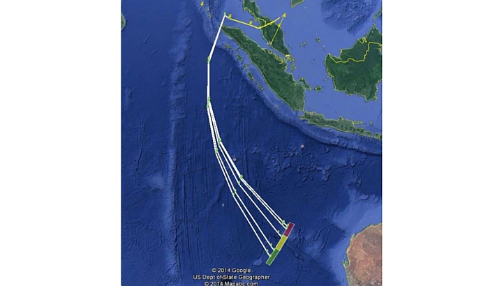
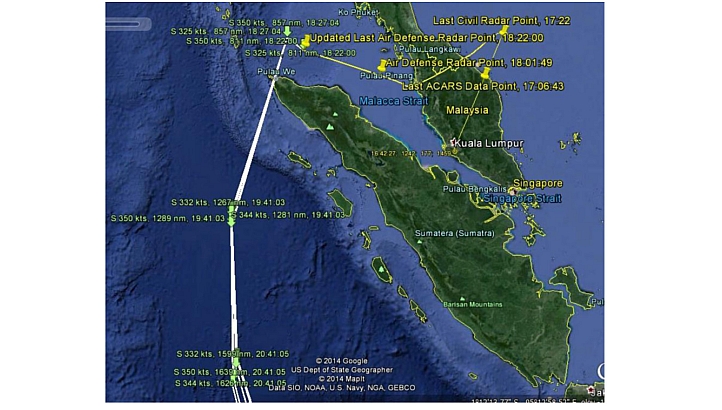
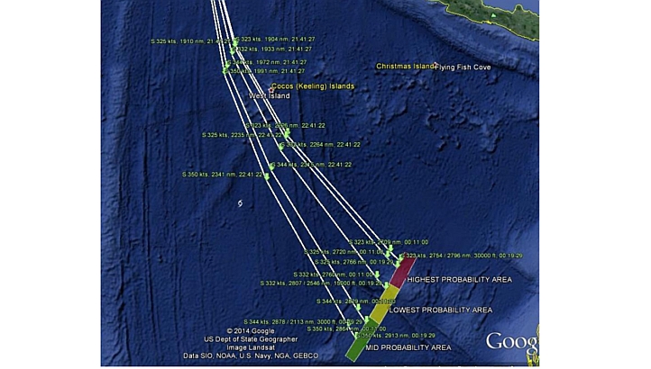
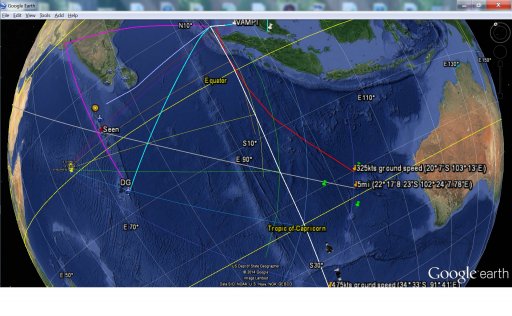
A map showing MH370’s flight path (also see notes to editors).
The cargo manifest for MH370.
The seating plan for MH370.
2. The military’s tracking of MH370
As stated previously, Malaysian military radar did track an aircraft making a turn-back, in a westerly direction, across peninsular Malaysia on the morning of 8 March. The aircraft was categorised as friendly by the radar operator and therefore no further action was taken at the time.
The radar data was reviewed in a playback at approximately 08:30 on 8 March. This information was sent to the Air Force operations room at approximately 09:00. Following further discussion up the chain of command, the military informed the Acting Transport and Defence Minister Hishammuddin Hussein at approximately 10:30 of the possible turn-back of the aircraft. The Minister then informed the Prime Minister, who immediately ordered that search and rescue operations be initiated in the Straits of Malacca, along with the South China Sea operations which started earlier in the day.
During this time, KD Mahamiru, the Mine Counter Measure Vessel and KD Laksamana Muhamad Amin, the Corvette Vessel of the Royal Malaysian Navy were already in the Straits of Malacca on patrol duties. They were immediately retasked to conduct the search and rescue operation. A military aircraft was then sent to join the two ships in the Straits of Malacca at 10:54 to search for MH370.
NOTES TO EDITORS
a. The audio recordings consist of five files which should be listened to in sequence.
b. The attached map shows MH370’s flight path, based on the best available knowledge of the investigation team. There are a number of possible flight paths to the southern Indian Ocean, and three boxes indicating where MH370 likely ended. These flight paths differ based on different projections of the aircraft’s speed, shown on the map in knots.
c. The attached preliminary report was drafted with the involvement of the NTSB, AAIB, ATSB, AAID and CAAC, as well as Malaysian officials
Audio logs
https://soundcloud.com/straitstimes/sets/audio-logs-from-mh370
Attachments
Last edited:
")