How Antarctica debunks the flat earth

I can, and have, verified drop heights of buildings over the horizon. I can see the starfield rotating around Polaris. I can see eclipses of the sun and moon. I can see meteors coming from a specific point. I can see seasons. I can see the effects of the Coriolis force. So many different things that point to globe earth. But we're off topic.

You are correct.. we are offtopic.. otherwise I would show to you every one of those things is false.. especially coriolis force.. if you put any unbiased research to it you would know that by now.
 
You are correct.. we are offtopic.. otherwise I would show to you every one of those things is false.. especially coriolis force.. if you put any unbiased research to it you would know that by now.
Oh, really - you mean this kind of research?

http://roundearthsense.blogspot.co.uk/search?q=coriolis

If coriolis is another thing that you have to reject to sustain a flat earth belief, how do account for the way that storm system consistently rotate in opposite directions in each hemisphere?

watch the animation in the first Youtube video linked above, or the second one). Of course, this shouldn’t happen on a flat, stationary disk Earth.

Why does Foucault's Pendulum always rotates clockwise in the Northern hemisphere, counterclockwise in the Southern hemisphere and at the equator it doesn't spin at all?

Why do snipers have to take it into account?
Snipers have to take coriolis into account.

Source: https://youtu.be/K8TEj4WeHuk


And military artillery manuals explain how to take it into account?

See Section 14 of this page:

https://www.metabunk.org/debunked-t...14-ways-the-flat-earth-theory-is-false.t7148/

Again, could we stay on topic now? If you want to raise other issues, either start a new post, or, if your new claim has already been discussed, find it and add to the existing discussion. Otherwise, it looks as though you are trying to distract attention for points you can't answer.
 
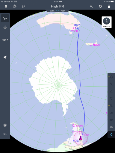
Abishua, I flew the QF28 flight from Santiago to Sydney a few days ago. I mean physically flew the aircraft, a 747.

We flew within sight of the Antarctic, down to 71.5 degrees south. We can go further south on that route but are limited to 71.5 south by lack of line of sight to the ATC communications satellites over the equator.

That in itself should tell you the world is not flat, however, can you understand that airlines are commercial entities, where containing fuel costs are paramount to maintaining profitability?

Santiago and Sydney are almost on the exact same latitude of 34'00 south. Sydneys Longitude is 151 deg East and Santiago is at 72 deg W. To fly between the two cities I must cover 137 lines, or degrees of longitude.. Correct?

The flat earth model has the distance between degrees of longitude becoming much larger as we approach Antarctica. This greatly increases the east-west distance the aircraft must fly to cover those 137 degrees of longitude. In this case the flat earth model makes it physically impossible to fly the distance on a full load of fuel.

Yet that is what we did. Because lines of longitude converge at the pole, the distance between them is shorter the closer you get to the pole. This is how great circle routes works and why airlines always fly an approximation of a GCR. The do get modified by winds and airspace restrictions.

Below are two representations of the route we followed.
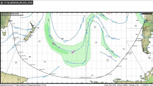

image.jpeg

image.png

The first does not depict the lines of longitude as they are or even as the FE model presents them. The do show the jets streams however.

The second is the actual route we flew, which was basically a straight line GCR modified for the winds on the day, and the 71.5S constraint. It depicts the lines of longitude converging at the pole, making this route the shortest way.

It may not be congruent with your beliefs, but that's the way we fly between these two cities, and we do it because any other way would cost too much fuel.

Sorry the FE does not exist. That's all there is to it.
 
Last edited:
can you understand that airlines are commercial entities, where containing fuel costs are paramount to maintaining profitability?
Beyond paramount, airlines exist on profit margins that are actually kind of scary when you see them on paper.
http://www.economist.com/blogs/economist-explains/2014/02/economist-explains-5
Despite incredible growth, airlines have not come close to returning the cost of capital, with profit margins of less than 1% on average over that period. In 2012 they made profits of only $4 for every passenger carried. Why has a booming business failed to prosper?
...
the outlook is brightening. America’s airlines are consolidating, passenger numbers are growing, especially in Asia, and forecasts suggest that global profits could hit nearly $20 billion in 2014, with margins of 2.6%—pitiful in other industries but stellar for airlines. Unless, of course, something unexpected causes the skies to darken once again.
Content from External Source
There's a lot of reasons for this (The article barely even gets into some of the more interesting ones), but the fact remains that light manufacturing in the US ran on a larger margin than this when it all but ceased to exist in favor of foreign imports. Airline execs have wild fever dreams about profit margins that other industries have just packed it in rather than face.

This is why airline food sucks, it's why you have to pay a fee for your carry on bags, it's why the drinks are so tiny, why there's no internet, why the in flight movies are all terrible flops from decades you don't remember happening. Because airlines operate on a margin so small that the showing fees for a better movie could actually cause a flight to incur a loss.
 
You are correct.. we are offtopic.. otherwise I would show to you every one of those things is false.. especially coriolis force.. if you put any unbiased research to it you would know that by now.
Start a new thread and show us how one of these things are false.
 
You are correct.. we are offtopic.. otherwise I would show to you every one of those things is false.. especially coriolis force.. if you put any unbiased research to it you would know that by now.
It takes math and science to understand coriolis. If we were in the flat earth fantasy world, coriolis would be a magical force, and can't be explained by reality base math and science.
Antarctica does debunk the flat earth model, and why would the flat earth model be surrounded by a flat earth "Antarctica". It makes no sense to argue flat earth using "Antarctica" as your anti-center of earth. Where is the center of earth, surrounded by an undefined massive all around earth "Antarctica". Does this mean the equations based on a flat earth version of coriolis will not be posted?
Got the distance around the flat earth "Antarctica", or a map of the flat earth? Better yet, can any flat earth person explain celestial navigation on a flat earth? No, just like coriolis and Antarctica.
 
Perhaps the most obvious way that Antarctica debunks the Flat Earth is that on the FE model, this place would be smeared out around the entire circumference of the disc:

upload_2016-11-24_11-41-15.png

I wonder where flat Earthers think it really is?
 
It takes math and science to understand coriolis. If we were in the flat earth fantasy world, coriolis would be a magical force, and can't be explained by reality base math and science.
Antarctica does debunk the flat earth model, and why would the flat earth model be surrounded by a flat earth "Antarctica". It makes no sense to argue flat earth using "Antarctica" as your anti-center of earth. Where is the center of earth, surrounded by an undefined massive all around earth "Antarctica". Does this mean the equations based on a flat earth version of coriolis will not be posted?
Got the distance around the flat earth "Antarctica", or a map of the flat earth? Better yet, can any flat earth person explain celestial navigation on a flat earth? No, just like coriolis and Antarctica.
Of cou you are right there. The problem is that many Flat Earth belivers live in a miraculous, prescientific word where they feel entitled to dismiss any phenomenon or finding of science if it conflicts eith their beliefs, without offering any depth of argument or evidence. To them, the word just is as a arbitrary God decrees it. Thats why those who claim to be Christian apologists are quite wrong. Christain mainstream thought has always beluved in a lawful universe governed by comprehensible Gods that can be understood by humans. FE denies that, to the extent thst msny leading Christians might have thought it blasphemous, an arrogant denial of God's authority, and of the reason that God gave us, in the Christian view.

@Abishua needs to think about this, to learn some theology, some history and philosophy of science.
 
"if some guy named Joe Shmoe did the timelapse.. hes a real person.. and uploaded it on youtube I would assume he has no special interest.. or is not financed by someone who does.. then I would have no reason not to beleive it..

I just want the truth.. flat or round.. so far.. seems flat to me.. but hey.. I guess time will tell.."


Hi, although I don't know a Joe Shmoe, I have seen a couple of personal time lapses taken from Antarctica. Because they're not professionals they didn't have the fancy rig that Anthony Powell developed for his sun tracking videos, but you can see the shadows move as the day progresses. Hopefully these will help clear up any confusion you were having about the 24 hour sun in Antarctica.
This first one is over a 2 week period filmed from the lounge window at Scott Base, skip to about 2.40 to see without cloudy skys:


Source: https://youtu.be/NdueeLWlWrw


This one was from McMurdo, from a scientist working in the Crary Building:


Source: https://youtu.be/D4lAVHiuvzg


The last one is another from Anthony Powell, it's interactive so you can choose where you look as the sun traverses the sky:


Source: https://youtu.be/8g3IbYcELDw
 
Even though it's been many months and it seems @Abishua has left the building after @TWCobra's epic mic drop post above, I'd still like to add that; why is it ok for FE's to show animation after animation of the sun circling a flat earth, but when real life video is shown of the sun circling the south pole, it is shunned and accused of being 'edited'? Do these people think those animations are real :confused:o_O:eek:???
 
Last edited by a moderator:
Here's a 24-hour time lapse taken about a kilometer from the South Pole. It was posted by Blaise Kuo Tiong, a scientist working on the IceCube Neutrino Observatory down there. The video was shot with a 185º fisheye lens, so you can see the Sun track across the entire horizon over the course of the day.


While a few structures are visible, the resolution is modest—anyone who thinks all the ISS footage is faked probably won't find enough pixels here to change their mind.

—Chris
 
Just thought of another way that Antarctica is shown to be a continent.

Every year planes fly from South America to McMurdo via the south pole (as well as other destinations). McMurdo is also reached by flying south from New Zealand. Flight times and distances obviously match the globe earth distances as well as the flight times. These flights happen every summer and there are many internal flights from base to base within the continent.

The planes that I'm familiar with are owned by Kenn Borek Air Ltd. ( http://www.borekair.com/services.html )
From their website:
ANTARCTIC

KBAL has been heavily involved in Antarctic operations for the past 27 years. In 2011 KBAL had a total of 17 aircraft on the Antarctic continent in support of scientific research.
Content from External Source
If anyone doubts this, then feel free to contact them via their website and let them know that their pilots can't navigate or don't actually know how fast they're flying!
 
From 1998 to 2013, Stanford operated a VLF receiver at the South pole: http://nova.stanford.edu/~vlf/Antarctica/SouthPole/SouthPole.html
At South Pole Station in Antarctica, the VLF group maintains a radio receiver system to measure natural VLF emissions in the 3 to 30 kHz frequency range. Two types of emissions which we often record at South Pole are chorus and auroral hiss. For more information on the VLF group's science objectives at South Pole, visit the AGO VLF Receiver homepage.

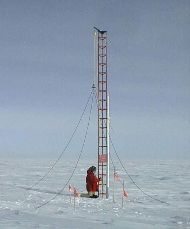
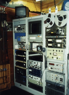
The VLF receiver system at South Pole records wave activity incident upon North/South and East/West crossed loop antennas shown in the picture below (left). A preamplifier is buried in the snow near the antenna. The remainder of the system is located in the Cusp Lab which is on the first floor of Sky Lab (the orange tower to the left of the main station dome pictured above). The racks containing the line receiver, GPS timing unit, mixer/moniter and analog recorders are picture below (right). Currently, we are recording synoptic broadband (1 minute out of every 15 minutes at 5, 20, 35, and 50 minutes after the hour) on the N/S antenna using the reel-to-reel AMPEX recorder. Continuous broadband from both the N/S and E/W antennas is recorded on Betamax tape for nine hours each day, 1300-1600 UT and 2000-0200 UT.

Note the cross-looped structure mentioned. What this means is that signals the antenna receives can have the direction of origin accurately measured. If antarctica was really an ice wall at the edge of the Earth, there should be no signals received from the "southwards" direction.

Pictures of the antenna system and signal processing units are attached.


This receiver was retired a few years back, but using wayback machine we can access the old website for the researching group: http://web.archive.org/web/20120709004524/http://www-star.stanford.edu/~vlf/Antarctica/AGO/ago.html

This page contains a number of data samples, as well as detailed reports of the calibration and signal processing done to the radio data received. The data obtained was the focus of a Stanford publicaiton from 2000 (http://onlinelibrary.wiley.com/stor...qe&s=5e90866add7a467ae5ec0ae51317549f487502af), which showed the low frequency waves detected lining up with satellite narrowband measurements of solar wind fluctuations.

A notable quote of interest from the publication:

During this period the WIND satellite was located at 213 RE sunward of the Earth while Geotail was located 13.5

RE behind the earth in the nightsidemagnetosheathregion. Figure 3 showsthe dynamic pressureand the magnetic field Bz component measured by the satellites, time aligned with the ground station data. The measurementsat Geotail are distorted with respectto thosemeasuredat WIND due to its position in the turbulent magnetosheath;however, promi- nent features are still visible. The travel time delay be- tween the satellites was estimated to be 55 minutes, and for alignment with ground data the WIND measurements were shifted +47 minutes and the Geotail measurements -8 minutes consistent with alignment of visible features and satellite measurementsof solar wind velocity.

These measurements would be impossible on a flat earth, where solar wind would reach all stations on Antarctica from a northwards direction.

The only way the Flat Earth model can be reconciled with this is if the entire Stanford VLF radio group, as well as all the teams managing the receivers and satellites involved, were in on the "conspiracy". This includes people I have personally worked with, and it would mean years' worth of data were entirely fabricated, all for a very obscure field of atmospheric sciences.
 
The only way the Flat Earth model can be reconciled with this is if the entire Stanford VLF radio group, as well as all the teams managing the receivers and satellites involved, were in on the "conspiracy". This includes people I have personally worked with, and it would mean years' worth of data were entirely fabricated, all for a very obscure field of atmospheric sciences.

Well, clearly you are part of the conspiracy too. The "conspiracy" is very, very large.
 
Yeah, I suppose nothing I mentioned is really convincing, but I thought it was an interesting area where my profession intersects some of the claims made here.
 
can you not see the footage has been edited? Look at the shadows of flags on the snow.. they cut the footage why..

let me see a real timelapse of 24hr sun..
That IS a real time lapse. Its a series of photos taken approx 20 mins apart.

The shadows move exactly as they should, as the sun is (from ground perspective) making laps around the horizon.
 
One more:


It's more than just one actually. It's a compilation of different timelapses from Antarctica.
 
I suspect they will just say it was filmed at the north pole.

EDIT: Hmm, but if the earth is flat shouldn't the length of the day be the same everywhere on earth? :/ i.e. no midnight sun on the north-pole either? That would be an easy way to disprove flat-earth hypothesis then, just observe that the length of day is different on different places on the earth.
 
Last edited:
Back
Top