Abishua, I flew the QF28 flight from Santiago to Sydney a few days ago. I mean physically flew the aircraft, a 747.
We flew within sight of the Antarctic, down to 71.5 degrees south. We can go further south on that route but are limited to 71.5 south by lack of line of sight to the ATC communications satellites over the equator.
That in itself should tell you the world is not flat, however, can you understand that airlines are commercial entities, where containing fuel costs are paramount to maintaining profitability?
Santiago and Sydney are almost on the exact same latitude of 34'00 south. Sydneys Longitude is 151 deg East and Santiago is at 72 deg W. To fly between the two cities I must cover 137 lines, or degrees of longitude.. Correct?
The flat earth model has the distance between degrees of longitude becoming much larger as we approach Antarctica. This greatly increases the east-west distance the aircraft must fly to cover those 137 degrees of longitude. In this case the flat earth model makes it physically impossible to fly the distance on a full load of fuel.
Yet that is what we did. Because lines of longitude converge at the pole, the distance between them is shorter the closer you get to the pole. This is how great circle routes works and why airlines always fly an approximation of a GCR. The do get modified by winds and airspace restrictions.
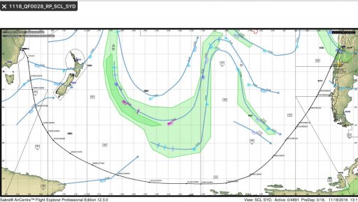
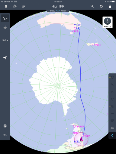
Below are two representations of the route we followed.


The first does not depict the lines of longitude as they are or even as the FE model presents them. The do show the jets streams however.
The second is the actual route we flew, which was basically a straight line GCR modified for the winds on the day, and the 71.5S constraint. It depicts the lines of longitude converging at the pole, making this route the shortest way.
It may not be congruent with your beliefs, but that's the way we fly between these two cities, and we do it because any other way would cost too much fuel.
Sorry the FE does not exist. That's all there is to it.


