Explained: How Mount Rainier helps demonstrate the shape of the globe

Rory

Closed Account
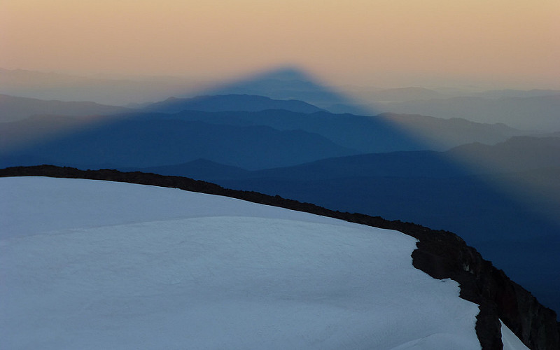
Here is a lovely shot of mountains in Oregon and Washington taken from the summit of South Sister in January 2007:

372202821_14e4920326_o.jpg
Source: https://www.flickr.com/photos/rhane/372202821/in/photostream/

The summit of South Sister is recorded as being ~10,360 feet above sea level (plus or minus 3 feet, depending on the source), and the GPS position of the photo, as well as I'm able to tell, is at or very close to 44.103500, -121.769250.

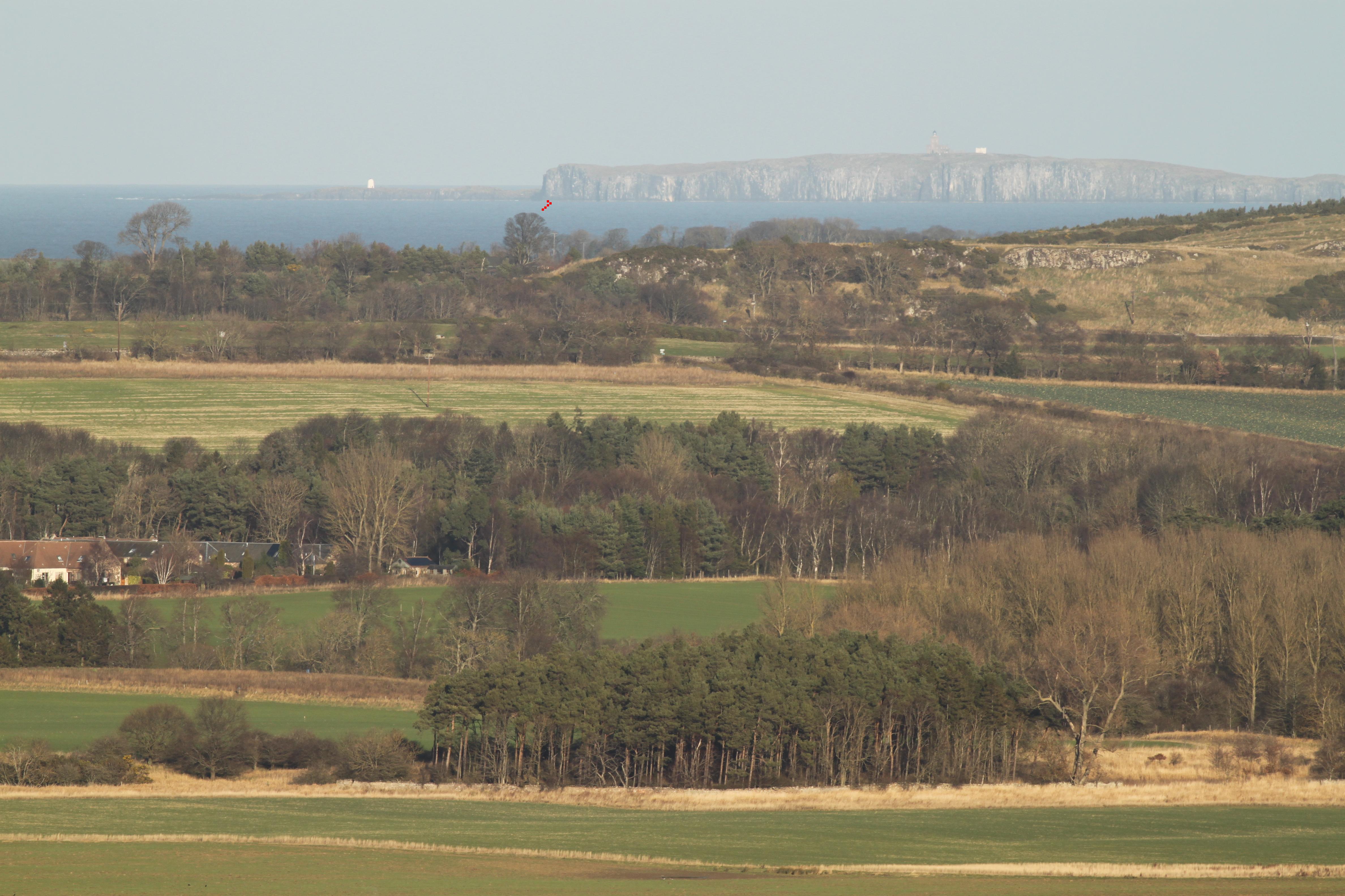
Here is the above image contrast-enhanced, cropped to the most relevant section, and with the mountain peaks labelled:

south sister to rainier.jpg

Elevations are taken from NAVD88. Other sources may vary up to 20 feet or so. These variations, however, make almost no difference to the results of the calculations, and zero difference to the conclusion.

This photo demonstrates that the Earth cannot be flat in a number of ways:

1. Everything in it aligns perfectly with a globe of radius ~3959 miles. Comparisons with globe-derived tools such as peakfinder, peakvisor, and Google Earth show no discrepancies.

2. A simple rule of perspective states that all points above one's eye level remain above eye level. If the earth were flat, Rainier should be the highest mountain in this photograph, with the viewer looking up to it. North Sister, however, which is lower than the camera, appears higher in the photograph than Mount Rainier.

3. If the earth were flat, Mount Rainier would be towering above Olallie Butte, rather than appearing at almost exactly the same apparent height.

4. Using simple pythagorean calculations, we can work out the apparent height order the mountains should appear in the photo if the earth was flat. They are (with their equivalent viewing angles):

upload_2018-12-26_11-48-56.png

(A positive angle indicates above eye level - i.e., looking up - while a negative angle indicates looking down.)


5. It's also possible to use the predicted angles to demonstrate even further the flat earth model's incompatibility with this photograph. Not only are the positions inaccurate, but the intervals between the predicted angles are wildly divergent from what is seen. Rainier, Olallie, Saint Helens, and Middle Sister, for example, are all at about the same apparent height in the photograph, whereas the flat earth model predicts that they would be spread apart at a range of over 1.2 degrees.

6. By calculating the viewing angles to these mountains for a spherical earth model, we can see that they agree to a very high degree of accuracy:

upload_2018-12-26_12-56-34.png

This time, the intervals between the angles agree with what is seen in the picture. The four mountains mentioned above - Rainier, Olallie, Saint Helens, and Middle Sister - are separated here by a difference of just 0.116 degrees, while the difference between Jefferson and Hood is about the same as the difference between Hood and North Sister.

The predicted order is also correct, apart from Olallie and Saint Helens, which are at exactly the same apparent height in the photo. This really is nitpicking, though: Olallie should probably appear only one or two pixels higher than Saint Helens, according to spherical calculations. A minute deviation of the camera from horizontal may explain this.

7. The angular size of the visible portions of the mountains are nothing like they should be on a flat earth, whereas they agree completely with a sphere earth.

8. Perhaps the most basic question for flat earth believers here is "where is eye level in this photo?" No matter where it is placed to align with two or more peaks, it will always be contradicted by others.

The rest of it is just gloss.
 
Last edited:
That's a beautiful graphic, thanks for doing that: looking at the difference between Olallie and Mount Rainier, which both appear at the same apparent height in the photo, really illustrates the point perfectly. :)

If you wanted to do one for how it would appear on a curved earth, the quickest way would be to lower each mountain by its respective drop figure. Though judging by your skills I'm guessing you already know a better and more attractive way.
 
Last edited:
Unfortunately, it is a lot harder to make an illustration for the globe Earth model, mainly because we need to have both x & y-axis using the same scale. But if we do that, then the distance to Mt. Rainer would be 70× its height, and we'll end up with a very long illustration horizontally. This is the same problem we cannot have a scale diagram of an eclipse in a single image, and still effectively convey the information.
 
Using simple pythagorean calculations, we can work out the apparent height order the mountains should appear in the photo if the earth was flat. They are (with their equivalent viewing angles):
upload_2018-12-26_11-48-56.png


i gotta tell you, checking your math is a royal pain :)

first i had to figure out how to do it (Khan Academy tutorial), then i had to find an online calculator with inverse tan (note to other laymen like me: you have to hit the function key)

then i had to subtract the camera height from all the mountain heights.
THEN i had to convert miles to feet.

sigh. i'm half way through and so far your calculations are all correct. I'm not even going to attempt to try to figure out how to do your angles on a sphere!! I might become a flat earther simply because the math is easier. :p
 
Lol. That sphere equation is a doozy, I know. ;-)

I made it slightly easier now. The attached spreadsheet has a column where it calculates the angle without factoring in for tilt, and the results are the same.

There's also an example section below to calculate for a hypothetical line of buildings, to show that the calculator does take perspective into account. This seems to be some flat earthers' prime objection. This one has an even simpler equation for the sphere earth - it's basically the same one as for flat, but also uses 'drop' (-2/3*d^2) and no refraction.

Well done you for getting stuck in! :)

Screenshot (505).png
 

Attachments

  • South Sister to Rainier.xls
    25.5 KB · Views: 583
but also uses 'drop' (-2/3*d^2)

globbety glib glob glee.

:) The truth is, when learning new science (or math) i can only process one thing at a time. I don't care what Sphere math is. I "get" that it is useful (to someone maybe) and it matches the photo but if i dont know how to verify what you are saying, then it doesn't help "me" much.

But on a Flat earth model, i COULD independently (after watching the Khan video..been a long while since i was in school) SEE the math formula needed and do that math myself, and see that Mt. Rainier would absolutely be the highest/tallest on a Flat Earth. Because the Elevation angle is just a fact of Mt. Rainier at a certain distance.

I did have to sketch it out for myself ,to fully grasp why "distance perspective" (the mountain looking smaller when further away) is already PART of the math. I don't excel at figuring out spatial problems in my head.

That's actually what the math IS specifically doing, figuring for "distance perspective".
for ex: if i pull Mt. Adams, at it's concrete real life size shown below, CLOSER to me it would obviously get BIGGER to my sight but that would change the elevation angle, as the green line would have to go up at a steeper angle. so your .231 does factor in perspective. and the ONLY way the green line would ever go higher than the pink line is if i physically move the mountain to a different location on Earth.

That's really the only question i was trying to figure out*, i dont care about sphere earth stuff or eye level. (i know you are right about those, but i personally need to focus on one concept at a time)


add NOTE: obviously my drawn mountains are not to scale. but an actual .231 angle is so tiny, and .143 even tinier that the angles would be too hard to see.
perspective.JPG

*well i also sketched out camera tilt, as i saw that in a FE video.. but that didnt change the colored lines because the slight change in distance that made, had to be applied to all the mountains. So my scene showed the same thing.
 
Last edited:
Well explained. What would you say the key is here to explaining to someone that the mathematics does take perspective into account?
 
Well explained. What would you say the key is here to explaining to someone that the mathematics does take perspective into account?

Seeing distance in the actual math formula was my first ah ha moment. In your OP you didnt show what formula you were using. Distance is the thing that makes objects appear smaller as the distance increases.
upload_2019-3-14_13-25-19.png

But still, for me its the example of sliding the green mt adams triangle in my picture around. like here i move it (and turn it aqua).. you can see the angle changes to a wider angle. let's say this wider angle is .201 ..the reason my new angle is bigger is because i made the mountain bigger by reducing the distance from me to it.

BUT i also sort of understand angles because i did take Geometry (badly :) ), but i do know other people that never got that far in Math. So i'm not sure what is "common knowledge" to me that others might not be understanding.

upload_2019-3-14_13-8-47.png


I will say that it took me quite a while to track down the math formula. and an easy tutorial explaining it and how to do it. https://www.khanacademy.org/math/ge...h-right-triangles/v/angle-to-aim-to-get-alien

But there they call it "angle of elevation". THAT i can grasp. when you guys talk about 'angular size" i have no idea what you are talking about. :)

I imagine what will resonate with people will vary depending on the person. Ultimately, even after i checked your math, i had to find my own way to figure it out (by drawing it). But to me "angle of elevation" kinda says the perspective is built in, because i can visualize that because i know if i move something closer the elevation angle changes. Probably what you were trying to say about looking at the ceiling or looking at a window.

if i built a scale model of the mountains and put them on my floor it would probably help too, but with a drawing i can draw the sight lines and quickly see the angle sight lines (the "angle of elevation" real meaning) and how they work. It's just what worked best for me.

Probably if i had seen your vid about the buildings first, i would have got that.. would help if you change your pen color and stop using the line tool :) Guessing the biggest issue is people need to know what formula you are using to arrive at your numbers. and if it is some funky formula like

(-2/3*d^2)
you have to tell me what that formula means. like is the 'd' in that "distance" or diameter? what is "-2" ? etc.
 
"Angular size" was also a fairly new term to me, and I don't think it's so helpful here, since to me (and others) it means the size of the whole mountain, whereas "angle of elevation" or my usual term "viewing angle" seem much more clear.

I think the drawing and sliding mountains around to raise the line is going to be very useful. That's good that this came up.

That last equation, by the way, is the dreaded "8 inches per mile squared" - to calculate the drop.

8 inches equals two thirds of a foot; multiplied by distance (in miles); and then ^2 is how to square something in excel (to the power of two).
 
The second one. ;)

It's a function of distance. So if you were looking at Rainier and there was nothing obstructing your view you'd have a triangle made up of: distance to peak; distance to base; and height of mountain. The angle formed by the two distance sides would be the angular size. For someone nearer than you, therefore, the angular size would be larger (it would fill up more of their field of view).

Mostly I come across it when people are talking about the sun or the moon. Their angular size (from earth) is ~0.5°.

This is quite a helpful little page:

http://astronomy.swin.edu.au/cosmos/A/Angular+Diameter
 
Last edited:
yea, thats what i can't grasp. if someone says "what is the angular size of Mt Rainier, do i say 14,411 feet? or
upload_2019-3-14_18-0-3.png
a size in feet is an actual size, or an absolute size. It tells you how big an object actually is.

angular size is the angle between a sight line to one edge and a sight line to the opposite edge.
It tells you how big an object looks like. This is perspective size.

angular size is actually proportional to pixel size for small-ish angles, so it is always proportional in zoom images.
for angles up to 10° off center the error is less than 2%, 10° is a 1:6 rise
you don't have to use trigonometry, you can just imagine you are looking through a window, this window is your pixel image, and then do proportions from your viewing position to the window and to the natural object. It's the kind of maths that even Rowbotham allows.
 
Angular size is the angle something makes at the camera. You draw a line from the top of the thing to the camera (to the center of the lens). You draw a line from the bottom of the thing to the camera. The angle between those lines is the angular size of that object.

Being an angle, you'd generally measure it in degrees.

But you can also measure it in pixels (or in feet) if you understand what you are doing. You've just got to think a bit about what an angle is.

An angle is really just how far around a circle you've moved one end of a line that has the other end fixed in the middle of the circle. We normally mark that circle from 0 to 360. But we could use different schemes. Like we could do 0 to 12

Metabunk 2019-03-16 13-03-44.jpg
What the hand points to there can be thought of as an angle, which indicates how far around the circle it is. The long hand is at 2, meaning the angle is 2/12 of a full circle (or 60° in ordinary degrees).

We can think of measuring the angular size of something in feet with a little trick. We image the circle (like the 360° or the 12-hour clock) as having its center at the camera, and its edge at the object. So now we have a circle where the radius (r) is the distance to the object.


Metabunk 2019-03-14 17-10-13.jpg

We want to measure angular size in feet, so how many feet are on this circle? That's just the circumference of the circle. 2*PI*r

Now here's the trick. When the object is really far away (like miles), the circle is really large. So there's no real visible difference between measuring feet along that circle and measuring feet along the object.

So in that instance, the angular size of the object measured in feet is the same as the actual size of the object!

Angular size in feet is specific to a certain distance. You can't just say something has an angular size in X feet, you have to note "at distance r"

So how would you convert that angular size to degrees? You could do that easily, but it's actually much more useful to convert it to the type of angle used in computer graphics, and mathematics, the "radian"

Radians are just like degrees, except instead of there being 360 of them around a circle, there's 2*PI (about 6.28318530718) of them around a circle.

Now we know the ratio of the angle to the full circle remains the same regardless of the units (that's really what an angle is, that ratio), so to convert to radians we note

angular size in radians / (2*PI) = angular size in feet / (2*PI*r)

that 2*PI is on both sides, so even though today is PI day, we can remove it.

angular size in radians = angular size in feet / r

So all you need to do to find the angular size of something is to divide its size by the distance.

(and since pixels can be considered a kind of angle, to get the size of something in pixels you just divide its size by its distance and then divide that by the field of view (the angle of the view represented by the screen) and multiply by the width of the screen in pixels - which all is kind of how 3D graphics works)
 
Last edited:
That said, while math is fun and good, this should really be approached with words anyone can understand. Look at the heights, including the viewer height.


The viewer is at 10,360. Mt Jefferson is about the same at 10,497. Rainier is about 4,000 feet higher, at 14,411

It's like there's three people, let's call them Sister, Jefferson, and Rainier.

Rory gave a similar analogy, but let's try for the very simplest logic, no numbers
  1. Assume the Earth is Flat
  2. Sister and Jefferson are the same height
  3. Rainier is much taller
  4. Sister looking at Jefferson is just looking at eye level (not up or down)
  5. Sister looking at Rainer is looking up, as Rainer is much taller than Sister
  6. If Rainer appears to Sister like he is below Jefferson, then the Earth is not flat.
That's the entirety of the logic needed. The only thing spoiling this as airtight is that Jefferson is very slightly taller than Sister. We can get around this by using another mountain (and Rory has discussed several), but Jefferson is such a clear example maybe we could use a point 137 feet below the top of Jefferson.

Either way - I think having an argument with no numbers might be more accessible to people thing "debunk with math" is a lie.
 
I like this approach to boiling it down as simply as possible, and I really feel all this is helping me in my discussions, as well as in understanding how perspective and apparent height aren't easily graspable by everyone.

That said, what I would expect in response to the above analogy might be something like this:


And then they would ask if we think the first and second stages of the Eiffel Tower are smaller than the child, even though we know they're not.

The answer there is that the camera is obviously a lot lower than the child. But for some people, it may not be clear enough to understand.
 
Angular size is the angle something makes at the camera. You draw a line from the top of the thing to the camera (to the center of the lens). You draw a line from the bottom of the thing to the camera. The angle between those lines is the angular size of that object.
so for Rainier, if im 10,360 feet up.. i would need to figure out the angle of depression and add it to my angle of elevation. ?

delete this if wrong, so i dont confuse people!
 
so for Rainier, if im 10,360 feet up.. i would need to figure out the angle of depression and add it to my angle of elevation. ?

Sure, you can add an "eye level" line into the mix, and have the angle from the top line to eye level, and then the eye level to the bottom line, and add them together to get the angular size.

Or you could just divide the distance to Ranier by the size of Ranier.

Of course it's a bit complicated for mountains, as you rarely see the whole thing down to sea level, and the bottom is quite a bit closer than the top - but the basics still apply. But you might want to pause and ask exactly what it is you are trying to figure out.
 
Last edited:
that requires them to understand prespective; that Rainier will never go below eye level. even if he is 100 miles further away.

Yeah, but it's a really simple aspect of perspective. Things above eye level stay above eye level on a flat earth.
 
Or you could just divide the distance to Ranier by the size of Ranier.
ok. thats opposite of the angle formula so i got confused.

so the angular sizes the FEers were asking for are:
Rainier 69.57
Adams 62.59
Hood 41.21
 
Last edited:
ok. thats opposite of the angle formula so i got confused.

so the angular sizes the FEers were asking for are:
Rainier 69.57
Adams 62.59
Hood 41.21

Ack, I wrote it the wrong way around. Divide size by distance. Sorry!
 
I like this approach to boiling it down as simply as possible, and I really feel all this is helping me in my discussions, as well as in understanding how perspective and apparent height aren't easily graspable by everyone.

That said, what I would expect in response to the above analogy might be something like this:


And then they would ask if we think the first and second stages of the Eiffel Tower are smaller than the child, even though we know they're not.

The answer there is that the camera is obviously a lot lower than the child. But for some people, it may not be clear enough to understand.
No, the answer is that the child is a lot closer to the camera.
The camera is also lower than the people in the background, and they appear smaller than the tower.
Which shows that it is the distance that matters for size.
For small angles, angular size is actual size/distance (in radians).
That said, the child is probably too close to simply apply this ratio.
So we'd better say, pixel size = actual size/distance * camera constant. That's always true if there is no distortion.

The concept of tallishness hinges on the question, what is closer to the top edge of the camera frame? The answer to this question is completely independent of angular size. To predict this, you consider a side-on orthogonal view, connect the tops of the objects with a straight line, and extend it past the camera (or eye). If the camera is above the line, the further object appears tallish, if the camera is below the line, the closer object appears tallish. If the camera is on the line, they appear equal.
image.png
In the yellow area, the camera is lower than the peak of A, yet B appears higher.

The angular size of A is equal to the angular size of B where the dotted line line meets the ground line (not shown in the diagram). If the camera is left of that (vertically), the pixel size of A is smaller than B, right of that, it is larger. Only the distance matters.

(The dotted line is slightly curved in reality because of atmospheric refraction.)
 
Last edited:
No, the answer is that the child is a lot closer to the camera.

Well, I suppose it's both of them: either move the child away or raise the camera - or both - and it'll cease to loom large over taller things.

That diagram above was helpful too, and the sort of thing anyone could test for themselves in the comfort of their own home just by looking at different objects.

I guess it must be time for a simple "perspective explanation" thread/video soon.

Also, probably about time I posted these:

south sister flat with lines.jpg

This places the predicted positions for a flat plane onto the photo, with eye level (zero degrees) placed a little lower than the summit of Mount Jefferson, and the intervals made to try and make as many peaks fit as possible. This shows three things: 1. That the predicted angles for the distant peaks are way off (they're more over the curve than the near ones); 2. That moving the scale to make those mountains better fit the image will throw all the other mountains out of whack; and 3. That this kind of proof really needs quite a lot of mountains, with a good range of distances and elevations, to be used to show it can't be made to work on a flat plane.

And here are the predicted positions for the sphere earth:

south sister sphere with lines.jpg

These line up pretty good. :)
 
Metabunk 2019-03-15 14-22-23.jpg

The above is a FOV (Field of view) volume for this shot, and might be useful in visualzing things.

If you open it up in GE, there's two planes switched off, and you can turn off others.
Metabunk 2019-03-15 14-23-55.jpg
The volume (know as a "view fustrum") has its apex at the camera, and the other end centered at Mt Ranier. The red p plane splits it in half vertically, so ends up at the top of Ranier.

Metabunk 2019-03-15 14-26-25.jpg

However, Hood and Adams poke through it, showing they will appear higher than Ranier in the image.

Metabunk 2019-03-15 14-29-02.jpg


You can also turn on an eye-level plane, showing Hood and Adams are below that.
Metabunk 2019-03-15 14-29-47.jpg

In fact everything is below eye level.
Metabunk 2019-03-15 14-30-43.jpg

There are also some red lines through the tops of some peaks, to the end
Metabunk 2019-03-15 14-33-09.jpg

You can see the lines of sight there are above the line of sight to Ranier
 

Attachments

  • MB_5268488A.kml
    7.7 KB · Views: 639
Wonderful stuff! :)

I've also been thinking a little more about how to demonstrate that calculators take perspective into account, and that the angles the calculators generate match reality.

One way to do this would be to take known distances and elevations and use them to generate a set of angles which could then be applied to a photograph, as I did above. This could be done 'blind', so that, for example, I could say to a flat earther, okay, if you provide with heights and distances, I'll tell you where those objects will appear in the photo.

A way to demonstrate this, I thought, would be to take a view of a row of buildings, such as down one of the New York avenues. If building heights and observer height is known, and if the street is relatively flat, then their predicted positions will be generated with ease.

I've found a site that gives buildings heights for cities in England - something like Oxford Street in England may do - but not one yet for the US. Though I would think it wouldn't be too difficult to find building heights for a street like 5th Avenue, and compare the generated angles to a photo like this:

upload_2019-3-16_13-17-8.png
 
Last edited:
I've also been thinking a little more about how to demonstrate that calculators take perspective into account, and that the angles the calculators generate match reality.

i think you're maybe better off with only focusing on one point and then you move. you can show the angle from a certain distance, and then move further away and show the same point at the new distance. (and you are showing the angle math of course, not just stating "the angle here is x".)

i thought google car because it moves, but unfortunately near me its real hilly. so anywhere long enough road wise to move has a hill.
The problem, with how i process information, with a city is you cant show a side view.

This is a horrible example because 1 our area has hills everywhere, so my car dipped in the second pic.. but 2. because TJ Max doesnt show in my side view as its pretty new, so my side view is a bit confusing.
here you can see i think clearly, the closer distance (pink) is obviously a greater/larger angle then the green long distance shot, but the side view shows me why.
tjm.png
 
Some work in progress - generating a FOV based on the camera for a view-fitted photo allows you to see how lines of sight are what builds up an image.
Metabunk 2019-03-16 12-23-17.jpg

Detail, showing how Hood and Adams line up
Metabunk 2019-03-16 12-31-38.jpg
 
Last edited:
Perhaps something like this will help?

three guys.jpg

C is taller than B, and A is taller than C.

Will there ever come a time, no matter how far away A goes, as long as he is visible, that C is looking down on him?

Ditto for B: will he ever be looked up to?
 
Perhaps something like this will help?

three guys.jpg

C is taller than B, and A is taller than C.

Will there ever come a time, no matter how far away A goes, as long as he is visible, that C is looking down on him?
yea. when walks over the horizon bulge and down the "hill" so all we see is his head.

But mountains and houses can't walk, so it's a different concept.
 
Sorry, I should have said:

"Will there ever come a time, on a flat surface, as long as A is visible, that C is looking down on him?"
 
well that took a while. I made a scale model in Second Life game. measured everything 3x and triple checked my eye level. i left some mountain tops sort of flat just so we dont lose the tip in the photo, but the flat top indicates the tip level. Anyway, that's Rainier in white in the back.

the Pink block way in the back is 10.360 feet or eye level to the camera, so yes.. on a FE Raineir stays above eye level
(Mt. Saint Helens which is the yellow block looks pretty tall too!)

upload_2019-3-21_14-0-35.png

zomming in so you can see the floating text labels
upload_2019-3-21_14-1-59.png
upload_2019-3-21_14-3-10.png
 
I just completed my own scale model too, and included showing the mountains on a curve. It's a bit slapdash, as is my style, but I think it demonstrates the point, and shows how it could be done by others, if they were curious. Video here:


Source: https://youtu.be/N3WMsPegImk

If anyone did want to do it, here are some of the figures I used:

upload_2019-3-27_15-17-33.png

The first four columns are straightforward, and the rest are to do with the drop and creating a curve. My first version (at 1:50000) 'simulated' a curve on a flat surface by adding the drop figure above Rainier to each peak, while the second one )1:125000) was made on an actual curved surface - a long pole - with one end 5.9cm higher than the other.

I may improve it slightly, just on the off chance it's not immediately and understandingly accepted by flat earthers. But hopefully others may take it up too.

(And, yes, it does include perspective. :) )
 
Last edited:
I did the scale model again, better and at a slightly smaller scale (1:87000) which allowed me to make bigger mountains:


Source: https://youtu.be/KRHBrne5cWU

The results were very pleasing, and despite the rough and ready nature of the model - bits of card from the bin; the bendy pole of a swimming pool net - it matches reality really well: Rainier, Olallie, and St Helens line up; Jefferson appears the highest; and Three-Fingered Jack is the lowest.

Putting them on a flat surface gives the expected results too.

I also lined up some household objects with the height of each 'cardboard mountain' and then spread them out to make the relative positions easier to see. This is what I got:

hairspray.jpg

Remarkably, everything's in the right apparent height order, with Rainier, Olallie Butte, and Mount St Helens all at the same level in the photo.

There are many better and prettier ways to scale this, of course, but that's the best I can do with what I have to work with, and it's not too bad. I'm blown away by how precisely it lines up with the actual South Sister photos.

Scaling calculator attached.
 

Attachments

  • scale model.xls
    38.5 KB · Views: 571
Last edited:
I also sketched out camera tilt, as i saw that in a FE video.. but that didnt change the colored lines because the slight change in distance that made, had to be applied to all the mountains. So my scene showed the same thing.

Here's a nice demonstration of why camera tilt doesn't make a difference to the relative positions of distant objects:

Camera tilted down:


Camera tilted up:


Camera level:


And all three stacked in a gif:

camera tilt.gif
 
Back
Top