Earth curvature refraction experiments - debunking flat/concave Earth

Isn't it a simple proof of a round Earth that if one day you measure the sun-to-horizon at zenith angle and then drive 500 miles north or south and measure it the next day?
 
Isn't it a simple proof of a round Earth that if one day you measure the sun-to-horizon at zenith angle and then drive 500 miles north or south and measure it the next day?
If you are to believe that the sun is just a few thousand miles away from earth, it's angle at Zenith would also vary in the flat earth model.
 
If you are to believe that the sun is just a few thousand miles away from earth, it's angle at Zenith would also vary in the flat earth model.

Yes but it would vary differently. If two people measured the Sun from 10° of latitude apart and another two measured it from 20° of latitude apart, each group would get different results for the height of the Sun.
 
Yes but it would vary differently. If two people measured the Sun from 10° of latitude apart and another two measured it from 20° of latitude apart, each group would get different results for the height of the Sun.
I agree people at different latitudes will observe different heights. But, other than the latitude difference, I don't understand why there are TWO people mentioned at each of two latitudes. (P.S. I may have initiated a thread here which is deviating from 'refraction')
 
If you are to believe that the sun is just a few thousand miles away from earth, it's angle at Zenith would also vary in the flat earth model.

Without doing the math, I think the Sun would have to be quite close for it to vary as much as the change in latitude causes. It would be interesting to figure that out. Somebody?
 
Could someone check my math(s) on this one?

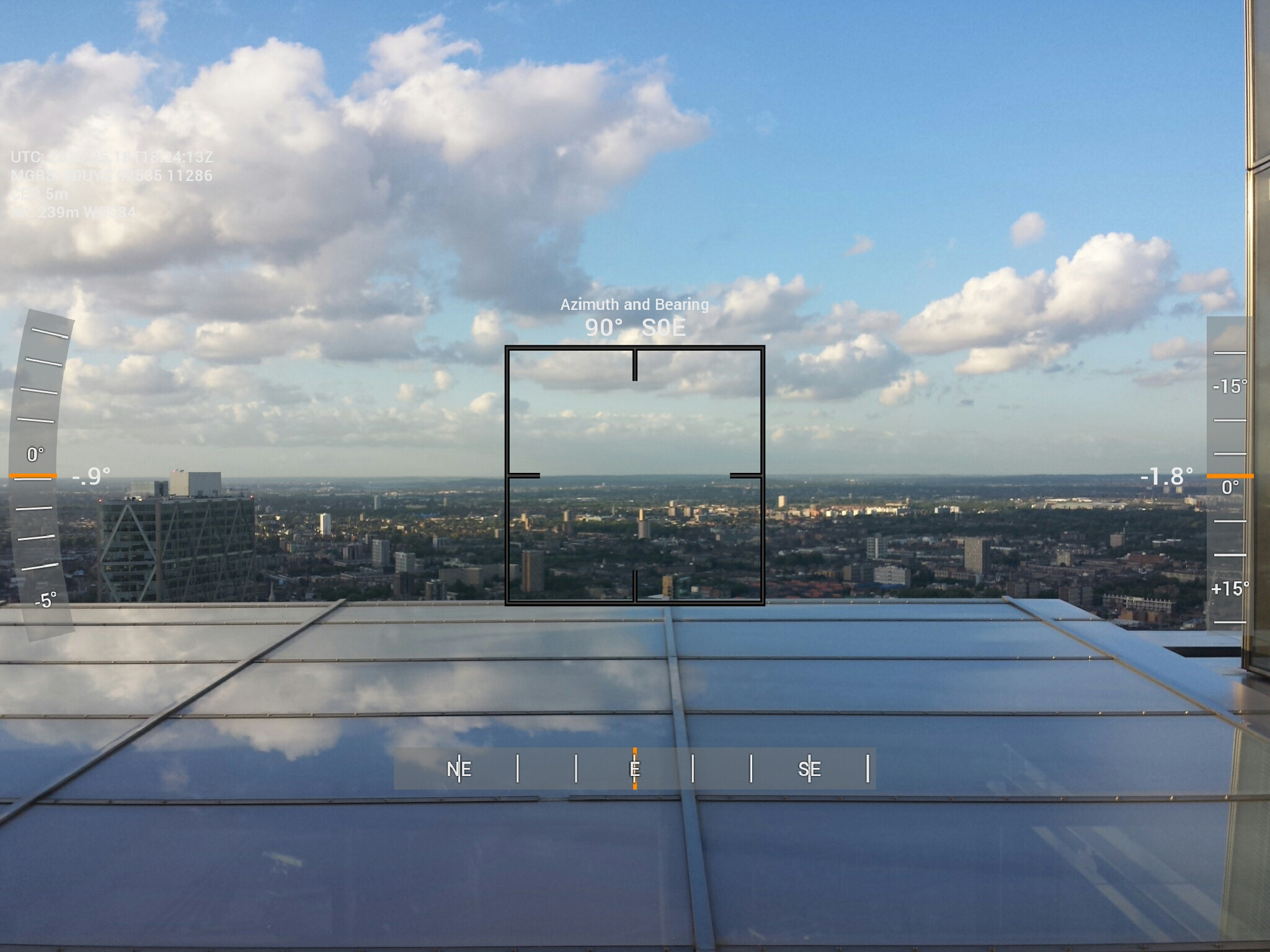
Picture taken with a theodolite app from a skyscraper in London:


We have altitude of 239m (769 feet) and I'm going to assume the horizon is at the same ground level (about 115 feet above sea level), which I think makes it 31 miles away.

Given those figures, I come up with an expected angle of -2.2°.

Is that right? Pretty close to what's displayed...
 
Last edited:
To make sure we are talking about the same angle dg (1):
upload_2016-6-17_5-48-15.png

dg = arccos(R/(R+h)). With h=239 m and R = 6371000 m I get dg = 0.5°
And a distance of 55.1 km = 34 mi.
If you take atmospheric refraction into consideration the picture changes slightly (1):
upload_2016-6-17_5-50-35.png
With the rule of thumb(1) that now R = 7/6*R(earth) the distance becomes 37 mi and the angle d will be slightly less than 0.5°
(1): Source: http://www-rohan.sdsu.edu/~aty/explain/atmos_refr/horizon.html
 
The horizon is 1.8deg above the level in that photo, so all that math was interesting, but unnessecary. I think it's safe to say the phone's sensors are inaccurate.
 
The horizon is 1.8deg above the level in that photo, so all that math was interesting, but unnessecary. I think it's safe to say the phone's sensors are inaccurate.
You are right. It would be interesting to know what the accuracy of these theodolite apps is, compared with the very tiny angles you want to measure, to see whether there is a point in trying anyway.
 
Are you sure? It reads -1.8.

Thanks for the better maths, Henk. I think you missed factoring in the horizon not being at sea level. But probably doesn't make that much difference.

Look at the scale on the right side. -15 is above the horizon. +15 is below.
 
Look at the scale on the right side. -15 is above the horizon. +15 is below.
That would also depend on which way the scale moves. If it scrolls "with" the image then the horizon would be above level. If it scrolls "against" the image then the horizon would be below level. I'd wager it's the second one, since I'm guessing the orange bar is kept center-of-frame, and it's shown above the 0° mark while the scale looks like it's shifted downward. [Never mind that sentence, I don't think I was picturing every possibility correctly.]

Simplest way to demonstrate would probably be to open the app and take two more arbitrary readings at above and below level, then see if the negative reading is the one looking up or looking down.
 
Last edited:
I haven't used the app but I imagine that the scale doesn't scroll, it's the orange line that moves. Pointing the camera towards the ground would bring the orange line further up into the minus range, and pointing it into the sky would bring the line further into the positive range.
 
I haven't used the app but I imagine that the scale doesn't scroll, it's the orange line that moves. Pointing the camera towards the ground would bring the orange line further up into the minus range, and pointing it into the sky would bring the line further into the positive range.
Then what happens when the angle becomes greater than 20°? It would either have to go off the scale, or the scale would have to jump.

Additionally, The scale already appears to have shifted slightly, and the orange bar is in line with the center of the image. Same with the roll angle on the left of the image.

I googled "theodolite app" and couldn't find anything that looked exactly like the one in the image, but I found a video demonstration of another:


In that one, the bars remain center-of-image, the scale shifts against the apparent motion of the image, and negative is below level. So if the two apps are anything alike, the horizon was indeed below level. How (or even if!) the phone that was used was calibrated, though, is an entirely different story.


That's the app I have. It is calibrated by placing it on a flat or vertical surface.
 
Update:

A follow-up story produced by Tom Coombes gives more details about the Chicago skyline "mirage." He talks about the difference between a mirage and looming:

http://www.abc57.com/story/31830937/skyline-skepticism-the-lake-michigan-mirage

A short lecture on atmospheric refraction and the difference between a mirage and looming, by Dr. Mark Rennie, Notre Dame:
http://www.abc57.com/clip/12393296/mirage-powerpoint


A time lapse video of the Chicago skyline "mirage." But is this looming? Or is it towering?
http://www.abc57.com/clip/12393288/mirage-time-lapse


An article by Dr. Andrew Young, San Diego State University: Looming, Towering, Stooping and Sinking
http://www-rohan.sdsu.edu/~aty/mirages/mirsims/loom/loom.html
 
Last edited:
Is it weird that it's come to this? However: here's a new video of a cruise ship sailing away from the viewer and over the horizon:


It's very long and obviously not much action, but skip through it and it's a nice example of seeing the effects of curvature.

Still, there are already plenty of comments saying it actually proves the flat earth. If they're not trolls, is it safe to say that they're truly beyond reason?
 
Last edited:
upload_2016-7-18_19-45-58.png
These are windmills at sea seen from a distance of between 36 and 45 km, disappearing for the most part behind the horizon. A Flat earther claimed " the picture was created or photoshopped, not an authentic picture taken from a camera. Thats why it appears like that. You will not see this in reality. "
But I know for sure that it is authentic, because I made it myself 6 months ago.
That's how they react when confronted with irrefutable proof.
 
Could somebody tell me how FE people explain the Sun/Moon, etc rising and setting at all?
They throw in a magical kind of perspective, unknown to the rest of the world. Their kind of perspective lowers things because for FE's the vanishing point is a real point at a certain distance and for some reason always on the horizon. I know this still doesn't explain how a setting sun can actually sink below the horizon. One FE'r suddenly came up with atmospheric refraction to explain why we see things behind the horizon, not realising that it actually makes things to appear a bit higher instead of lower.
 
They throw in a magical kind of perspective, unknown to the rest of the world. Their kind of perspective lowers things because for FE's the vanishing point is a real point at a certain distance and for some reason always on the horizon. I know this still doesn't explain how a setting sun can actually sink below the horizon. One FE'r suddenly came up with atmospheric refraction to explain why we see things behind the horizon, not realising that it actually makes things to appear a bit higher instead of lower.

Do they think all the stars and planets, etc are orbiting Polaris?
 
Do they think all the stars and planets, etc are orbiting Polaris?

Yes, they do. But since the Earth does in fact rotate, this means stars around the north celestial pole will appear to rotate in the opposite direction as stars around the south celestial pole. Flerfers excuse this paradox by claiming the time lapse videos of the south celestial pole are recorded then ran backwards. That explanation, of course, doesn't explain why stars closer to the south celestial pole make smaller circles.
 
Yes, they do. But since the Earth does in fact rotate, this means stars around the north celestial pole will appear to rotate in the opposite direction as stars around the south celestial pole. Flerfers excuse this paradox by claiming the time lapse videos of the south celestial pole are recorded then ran backwards. That explanation, of course, doesn't explain why stars closer to the south celestial pole make smaller circles.

How could there even BE a south celestial pole on a flat Earth?
 
They throw in a magical kind of perspective, unknown to the rest of the world. Their kind of perspective lowers things because for FE's the vanishing point is a real point at a certain distance and for some reason always on the horizon. I know this still doesn't explain how a setting sun can actually sink below the horizon. One FE'r suddenly came up with atmospheric refraction to explain why we see things behind the horizon, not realising that it actually makes things to appear a bit higher instead of lower.

They explain it using refraction and two other variables: altitude and distance. The affirmation is that because the sun is too high and away from us, it makes the effect of the astro belowing the horizon. Here is the statement of one saying that:

Boa noite , esse argumento não procede . Antes de reproduzir algo , devemos introduzir todos os componentes do fenomeno , coisa que vocês não fizeram . Primeiro , é cientificamente comprovado que o alcance da visão humana é de aproximadamente 5 km , isso para alguém que tem 1 metro e 80 de altura . Portanto , a altura que estamos nos permite ter um alcance maior em relação ao horizonte . Segundo , aumentar o alcance da visão com cameras para enxergar barcos a longas distancias (Galileu e Euclides Refutados) é totalmente diferente de olhar para o sol , pois barcos estão no mesmo nível da altura de nosso olhos e de nós , já o sol não . Isso vale para os aviões também , olha a altura que o avião está cara ....... Aviões e o sol aparecem subindo e somem descendo , quando ''descem'' , alem de estarem alto , estão muito distantes . São proporções totalmente diferentes e distancias colossais , além disso , como estão mais altos que montanhas e etc , como o zoom nos permitiria enxergar o sol ou aviões da altura que estamos se estamos abaixo de todos esses obtaculos ? . O que refuta tudo isso que vocês falaram é balões , pois muitos deles foram soltos quando ja era noite e quando chegaram na estratosfera foi possivel ver o sol , porque o campo de visão da camera está alto o suficiente para nenhum obstaculo impedir de ver o sol . Cara , alem de pequenos , estamos fixos no chão , a primeira coisa que voce deveria ter feito é comparar a nossa altura com a dos barcos , que está OK e comparar nossa altura com a altura dos aviões .
Content from External Source
Translation below:

Good night, that argument doesn't proceed. Before reproduct something, we must introduct all the phenomenon's components, thing that you didn't. First, is scientifically prooved that the human vision's reach is nearly 5Km (3,11mi), this for someone 5,91ft tall. So, the height we are alows a bigger reach in relation to the horizon. Second, grow the vision's reach with cameras to see boats at high distances (Galileu and Euclides refuted) is totally different from look to the sun, because boats are in the same height level of our eyes and from us, but the sun not. This is valid for the airplanes too, look at the height the airplane is, man... Airplanes and the sun appears rising and vanishes going down, when " goes down", and both are high and very away. These are totally different proportions and colossal distances, and it's higher than mountains. How the zoom would allow us see the sun or airplanes at the height we are if we are below all this obstacles? What refutates all it you spoke are balons, because many of it were released at night and when it reached the stratosphere it was possible to see the sun, because the camera's vision camp is sufficient high to no obstacle block to see the sun. Man, beyond we be small we are fixed on the ground. The first thing you should have done is compare our height with the one of the boats, that is ok, and compare our height with the one of the airplanes
Content from External Source
The curious thing is that according to most flatearthers the sun and monn are 3000 miles, so the camera in the stratosphere would still be in a lower plan of the sun.

PS1- To contextualize: the comment above was a response to a challenge made months ago toward a flatearther page. They should take a telescope and observes the sunset from the seashore: if the sun is still visible even after set, would be proven that it only gets away.

PS2- Any flatearther has ever gave any explication how the temperature is maintained under control in a Flat Earth closed by an impenetrable crystal/glass dome? How the Earth is not a greenhouse with temperatures much higher?

PS3- And if outside is literally a lot of water, how it pressure on the dome doesn't influenciate down here?
 
Hi, I have a question about Earth's curvature. I've read somewhere or was it in the video I watched that for every mile of Earth's (circle's?) circumference, curvature or distance there is a drop of 0.318 mile. Without any complex formulas I tried to verify and it seems correct. Yet I see they are talking about just a few feet of drop per mile. Since I am not good at math, it confuses me which one is correct? Earth's circumference is 40075 km, so one 1/4 of the way around Earth is roughly 10.000 km. Traveling that distance we "drop" about 3000 km, otherwise we would end up in space, since the Earth is round. Or am I missing something? P.S.: Sorry, I don't understand the complex formulas on this page. Thank you.
 
Hi, I have a question about Earth's curvature. I've read somewhere or was it in the video I watched that for every mile of Earth's (circle's?) circumference, curvature or distance there is a drop of 0.318 mile. Without any complex formulas I tried to verify and it seems correct. Yet I see they are talking about just a few feet of drop per mile. Since I am not good at math, it confuses me which one is correct? Earth's circumference is 40075 km, so one 1/4 of the way around Earth is roughly 10.000 km. Traveling that distance we "drop" about 3000 km, otherwise we would end up in space, since the Earth is round. Or am I missing something? P.S.: Sorry, I don't understand the complex formulas on this page. Thank you.

Neither is correct, in fact any version of "the earth drops X inches per mile" is incorrect because if the earth dropped the same distance per mile then we'd be living on a flat slope.

The earth is a sphere, so the surface is curved, so unfortunately you have to use a teensy bit more complicated math if you want to get the right number.

You also have to ask the right question. The "drop" value isn't really a useful number for visual observations. You generally want to know how much of something is hidden by the horizon. To calculate this "hidden" value you need to know two numbers: the height of the observer (h), and the distance to the target (d)

Have a look at this interactive simulator. Move the "Camera" and the "Target" around:
https://www.geogebra.org/material/iframe/id/1153831

You can move the camera very close to the Earth's surface to make the "Obscured" value approximate "drop" calculations. But note also the "Bulge" value.
20160728-070325-8gdz1.jpg

20160728-070544-8h9mg.jpg

Really though you are not laying down with your eye one inch above the surface. So your height does come into play.
20160728-070628-ivoet.jpg
 
Thanks. I understand that for 2m of eye level we get about 5km of horizon (the Horizon figure is not shown on that website) Geogebra a great website tool to understand (visibility of the) curvature of Earth. It is clear that for a human standing on flat ground is impossible to see curvature of the Earth since their horizon line is within 5 km from where they are. I noticed that the longer the distance number is, the bigger the percentage of the bulge relative to the distance. One question arises: do they (geodezists etc.) measure road and geographical distances by "distance" (1633 in Fig.1) "cutting through the Earth's curve" in a straight line (like a string) or by actual "curved-distance" (1645 in Fig.1) they print on road signs, printed maps etc? And if they measure and record distances by the "distance" cutting through bulge, and I am not a flat-earther, but I wonder, since the Earth is obviously a sphere, why wouldn't they measure distances by curved-distance, if they do? I know they must measure distances by "as the crow flies" and also by "as the road curves", but distances for air flights, building a railway, a river bridge, a canal etc? Do they include the curvature of Earth into all those figures? And yet another question, if I may: When an airplane flies, do they adjust to the Earth's curvature (bulge) all the time, even that they fly at around 30000 to 40000 ft. most of the time?

What is the best elevation in the air to visually (without camera lens) observe curve of the Earth?
 
Here we go, I have seen these videos before but didn't think to suggest it here as an experiment to prove the Earth is not flat.
I believe this sort of experiment is relatively easy to get permits (if needed) for and cheap enough now a days to do. GoPro and a weather balloon.


Great experiment and video! The Earth appears curving up and down like a wave. Wonder why's that? Lens distraction?
 
Over long distances distance is measured along the curvature. Over short distances the difference in assuming the Earth is flat doesn't matter.
 
Great experiment and video! The Earth appears curving up and down like a wave. Wonder why's that? Lens distraction?
Unfortunately the flat earthers don't believe those videos because mostly they use GoPros, which as we see causes curvature anyway.
 
Unfortunately the flat earthers don't believe those videos because mostly they use GoPros, which as we see causes curvature anyway.

Sorry, I am not as advanced in technology (or etc?) as you are. What's that that you are talking about if you don't mind to share with me? GoPros? Once in the past I was confronted by a flat-earther (which I found debilitating) and I had no argument to confront them with on why the Earth was round. From then on I would like to arm myself, with a help of this forum, I hope?
 
Back
Top