Earth curvature refraction experiments - debunking flat/concave Earth

I must not have chosen the correct word to describe what I meant by symmetrical. What I meant by symmetrical is that I am not limited to only entering the viewer's height and distance in order to calculate the obstructed height. But by 'symmetrical' I mean that I can enter the obstructed height instead of viewer height and have it calculate the corresponding viewer height. What's a better word for describing this...'Inversability'?
I’m confused. Since both the viewer and viewed are referenced to the same water line (WL), if the viewer is at 115 feet above WL and the curve calculates that the corresponding height is 1225 feet above WL, how could any portion of Grand Mere, be seen if they’re 740 feet high?
 
I must not have chosen the correct word to describe what I meant by symmetrical. What I meant by symmetrical is that I am not limited to only entering the viewer's height and distance in order to calculate the obstructed height. But by 'symmetrical' I mean that I can enter the obstructed height instead of viewer height and have it calculate the corresponding viewer height. What's a better word for describing this...'Inversability'?

Yes, I misunderstood you, sorry. I'd edited my post to remove that while you were typing your response.
 
I’m confused. Since both the viewer and viewed are referenced to the same water line (WL), if the viewer is at 115 feet above WL and the curve calculates that the corresponding height is 1225 feet above WL, how could any portion of Grand Mere, be seen if they’re 740 feet high?

Clearly there's an error somewhere here. It may have to wait until the AM though :)
 
I could have simply said the calculator serves a 'dual purpose'.
I used to live in S.F. and the Farallon are 'just' 27 miles offshore. Even on a good day, the view of them is not especially distinct. But for an assumed 56 miles across a body of water, the clarity of this image seems awfully good. Perhaps the image was taken from a ship.
 
I used to live in S.F. and the Farallon are 'just' 27 miles offshore. Even on a good day, the view of them is not especially distinct. But for an assumed 56 miles across a body of water, the clarity of this image seems awfully good. Perhaps the image was taken from a ship.

But then why can Google Earth replicate the image from Grand Mere?
 
... If we only knew the height at which the photo was taken, we could then discover how much difference refraction makes across such a distance.

On Joshua Nowicki's FB page he stated he was atop a dune. Others and I have asked him the approximate camera elevation, but I have never seen him reply.
 
Upon reflection, it seems I was a little careless in saying the Google Earth view matched the Nowicki image. It does not, and in fact it seems clear that there is actually either some significant looming effect going on in his image, of the location is mislabled. The tops of many buildings that are visible in the GE fit are not visible in the Nowicky image I used:


Compare to this image, also labeled as being from Grand Mere:


While the Willis tower looks taller in the first image, there are fewer building visible.
 
Okay, I think I've figured it out.

Firstly the highest spot in Grand Mere is about 811 feet, so is 234 feet above the 577 feet altitude of the lake. So at 56 miles, the occluded height is 926 feet. Willis tower is 1450 to the base of the antenna, plus 20 feet street to lake, so 1470.

926 occluded of 1470 is 63%

Google Earth does NOT do a good job at occluding with the surface of the lake. However you can add a path on the surface of the lake and it will render that correctly.


As you can see in this view it does some odd double horizon thing, with a transparent line where the actual lake surface would be. I suspect the opaque blue is actually sea level. So the actual pure view of Chicago from the 811 dune is much closer to this:


Just measuring it on that image indicated 55% occluded. Given the inaccuracies in Google earth, I think that's close enough.

New KMZ with the 811 dune and the surface path added.
 

Attachments

  • Flat Earth - Chicago Photos - v2.kmz
    3.9 KB · Views: 1,206
I realize this is not of interest to many people, but I like to get things right. Anyway, here's another way of rendering the surface of the lake more accurately:

A squiggly path across the lake:


And verify it works fine at sea level:


Actually a few pixels off, but way better than the lake obscuration
 
Although the 811 dune is actually in the park to the south. Gah, I give up, the Earth is flat!

Grand Mere State Park (Lat: N 42° 00' 38.66", Lon: W 086° 32' 32.40"), between Bridgeman and Stevensville, has a maximum elevation of 770' and maximum trail elevation of 760' on Baldtop. I suspect this is the location the photos were taken from.
c76542bdf666e2e2003648f00bb74f48.jpeg
 
I go to a beach on the Sound. You can see here the distance across is about 19 miles.

iron pier1.PNG


When I approach the shore on this road, at this point here which is the top of the bluff...

iron pier 2.PNG

I can CLEARLY see lower on shoreline on the opposite side...(especially at night when I can see lights on the other side)...

than here, at the end of the road at the bottom of the bluff...

ironpier3.PNG

Now I understand that I am at a higher vantage point there at the top of the bluff, but if the earth were flat wouldn't I see the same shoreline from either spot? I have to assume no flat earthers live where you can look across a body of water to the shore on the either side.
 
This video is funny with eyes of the flat earthers. Video from 110000 feet.


Talking about the hot spot of the sun (4:19), the sun isn't that far how the scientists claims.

But after 5:53 you start to see (clearly) curvature of the earth. And..

449b65ab0c17773671abb0f8bca1fe26.jpg
 
I realize this is not of interest to many people, but I like to get things right. Anyway, here's another way of rendering the surface of the lake more accurately:

A squiggly path across the lake:


And verify it works fine at sea level:


Actually a few pixels off, but way better than the lake obscuration

Am I missing something here? It seems to me that the Google Earth projection of the expected view and the actual photo don't match up?

Also, something I considered some time ago is that the height of the waves might obscure more or less of the city at that distance, regardless of a globe earth or flat earth.

If you look at the two images of 'real photographs', that may account for the difference, as the lake looks much choppier in the image where we see less buildings.

Why would relatively short waves obscure by comparison huge buildings?

Perspective and distance. Just a thought.
 
Upon reflection, it seems I was a little careless in saying the Google Earth view matched the Nowicki image. It does not, and in fact it seems clear that there is actually either some significant looming effect going on in his image, of the location is mislabled. The tops of many buildings that are visible in the GE fit are not visible in the Nowicky image I used:


Compare to this image, also labeled as being from Grand Mere:


While the Willis tower looks taller in the first image, there are fewer building visible.

Wouldn't say it looks taller in the first image - the first image looks like it is more zoomed in than the 2nd.
 
Why don't you measure it?

Scaling them to the same size [aligning the buildings left to right], the tower is shorter in the first image, but it's elongated with improper proportions.

Suggests the second image was take at quite a bit higher elevation than the first.
 
Here is a couple of photos from a flight from Perth to Sydney a couple of days ago. The first two show curves in a distant contrail from an aircraft that was maintaining a steady 38000 feet.

image.jpeg

image.jpeg

The inversion layer visible in the photos marks what is level.

The next few photos are a series depicting our approach to a long frontal cloud that started on our left, crossed our path at a distance and continued further into the distance, over the horizon. You can see that when far away, the cloud dips below the horizon with a prominent curve.
This curve disappeared as we got closer. The sequence was shot over an hour (about 900 km) as we approached Adelaide. The cloud layer tops stayed approx 3000 feet below us for the entire sequence. Once again the inversion layer is useful.

image.jpeg

image.jpeg

image.jpeg

image.jpeg

Now crossing the layer...
image.jpeg

This shot (out of sequence) shows the curve in the distance as we looked down the line of the cloud to the right.
image.jpeg
 
Here is a couple of photos from a flight from Perth to Sydney a couple of days ago. The first two show curves in a distant contrail from an aircraft that was maintaining a steady 38000 feet.

Much appreciated =) Will be super interesting going through these!
 
Why don't you measure it?

Just found the full time lapse:


They're saying mirage. I had no idea a mirage could have such detail and colored lighting.

Assuming it is a mirage, that is =)

It gets quite wobbly near the end there - indicating mirage activity going on. But a projection that large of the city in the atmosphere when the city isn't actually there? Interesting to say the least.

And, again, not nearly as straight forward as people like to push.


I'm not clear on what you think a mirage is? The city is "there" (partially below the horizon). There are just some very slight bends in the path the light from the city take to get to the camera, which allows you to see more of it, and distorts and stretches the image. There is zero reason for there not to be "detail and colored lighting".

This ship is there, the "mirage" parts of the image are detailed and colorful.

Yes I see for sure the skyline blurring and wobbling is a mirage.

As you see in the ship example you gave, we don't see 'more ship' - we see the whole ship we would otherwise see but in a distorted fashion. (and upside down partly?)

Comparing the Chicago skyline mirage with your Google maps 'how much should we see' photo, I'm wondering whether a mirage can place that much of a building that is not in view into view.

As with the ship, it is already in view from top to bottom - it just becomes distorted due to the mirage.

I get it though, you're looking at it from the perspective of 'obviously the earth is round, therefore a mirage must be able to do this' - and I understand why. However, if I am going into this with the intent to verify the earth is round, I cannot first assume it is, right? That would conflict with my entire purpose.
 
Some of the building is above the horizon. The "mirage" just lets you see more, and stretches/inverts it.
 
Last edited:
I'm not clear on what you think a mirage is? The city is "there" (partially below the horizon). There are just some very slight bends in the path the light from the city take to get to the camera, which allows you to see more of it, and distorts and stretches the image. There is zero reason for there not to be "detail and colored lighting".

This ship is there, the "mirage" parts of the image are detailed and colorful.
This is a most interesting image. It looks to me like there is a temperature inversion layer somewhere about mid-cabin height on the ship. We are looking simultaneously above, below, and "through" the inversion layer. Above the layer we see the funnel and the foremast. Below the layer we see the erect image of the hull, and the bottom of the foremast. Bow wave and prop wash are detectable, so the ship is not hull-down. "In" the inversion layer (actually, reflecting off of the bottom of it, we see the inverted image of the hull, the waterline, and a reflection of the foremast. Reflections of the deck cargo (or deck machinery) amidships is also evident. This condition probably exists as a result of a cold front displacing warm air upward, creating an inverted temperature profile. The air is less dense above than below, because light is being bent downward from ship to inversion layer to camera.
 
Remember the light isn't traveling in a straight line; it's difficult to determine the height of the inversion with a single photo, and is almost certainly not where it appears. I'd also disagree with your cause; the marine layer is the likely cause, especially given the low apparent height. Water is an excellent heat sink, and air is a poor heat conductor, so the lowest portion of a column of air is cooled considerably by contact with cool water, creating an inversion.
 
The ship mirage is a Fata Morgana, a details explanation of which is found here:
https://en.wikipedia.org/wiki/Fata_Morgana_(mirage)

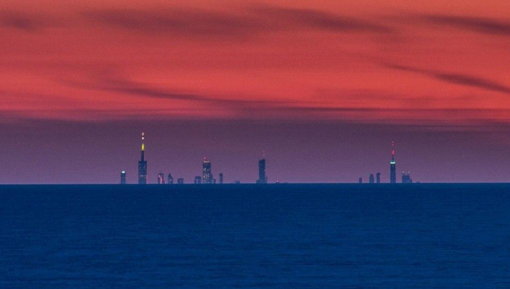
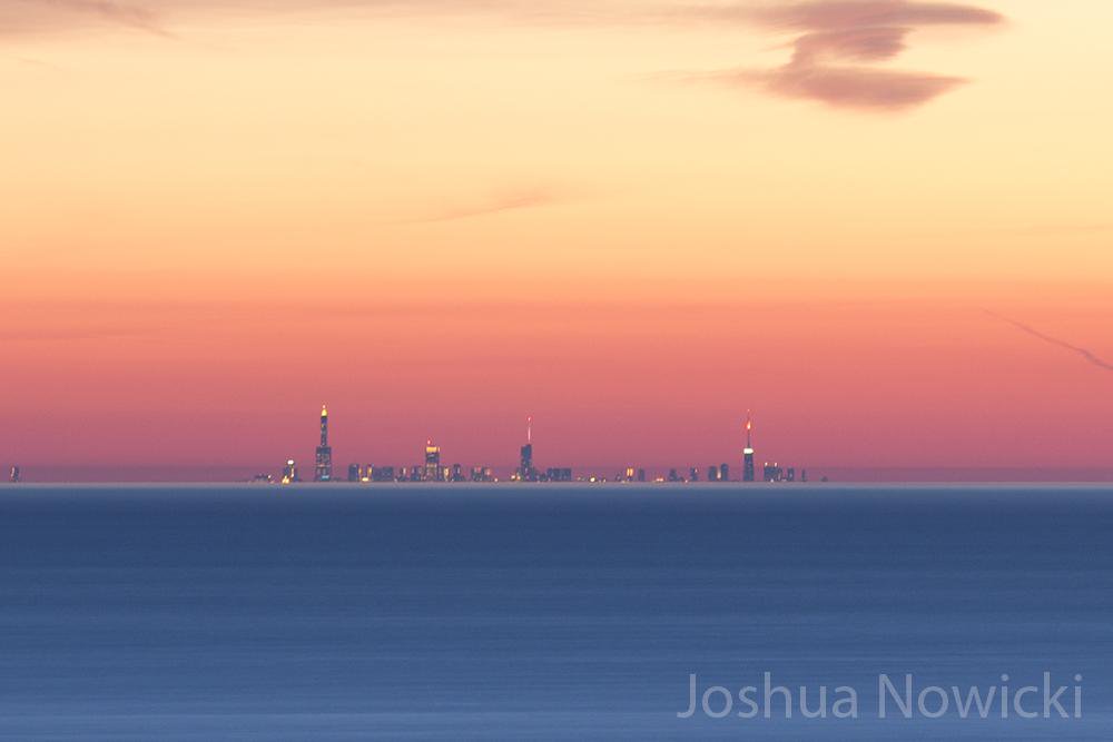
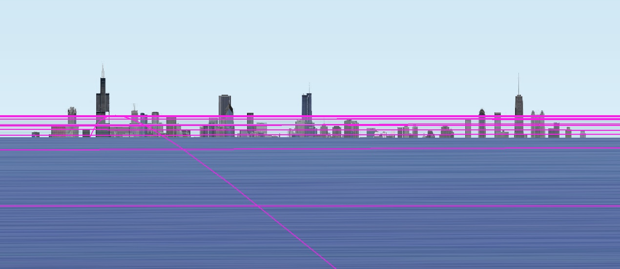
A Fata Morgana is often rapidly changing. The mirage comprises several inverted (upside down) and erect (right side up) images that are stacked on top of one another. Fata Morgana mirages also show alternating compressed and stretched zones.[1]

This optical phenomenon occurs because rays of light are bent when they pass through air layers of different temperatures in a steep thermal inversion where an atmospheric duct has formed.[1](A thermal inversion is an atmospheric condition where warmer air exists in a well-defined layer above a layer of significantly cooler air. This temperature inversion is the opposite of what is normally the case; air is usually warmer close to the surface, and cooler higher up.)

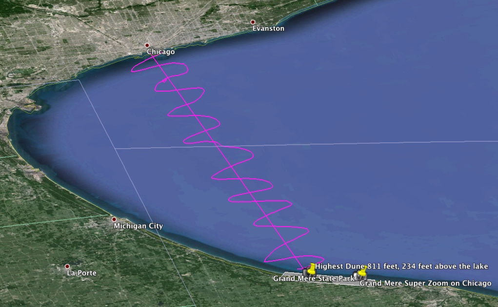
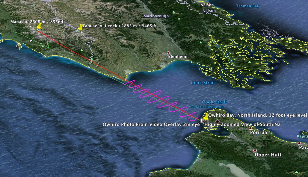
In calm weather, a layer of significantly warmer air can rest over colder dense air, forming an atmospheric duct which acts like a refracting lens, producing a series of both inverted and erect images. A Fata Morgana requires a duct to be present; thermal inversion alone is not enough to produce this kind of mirage. While a thermal inversion often takes place without there being an atmospheric duct, an atmospheric duct cannot exist without there first being a thermal inversion.

...

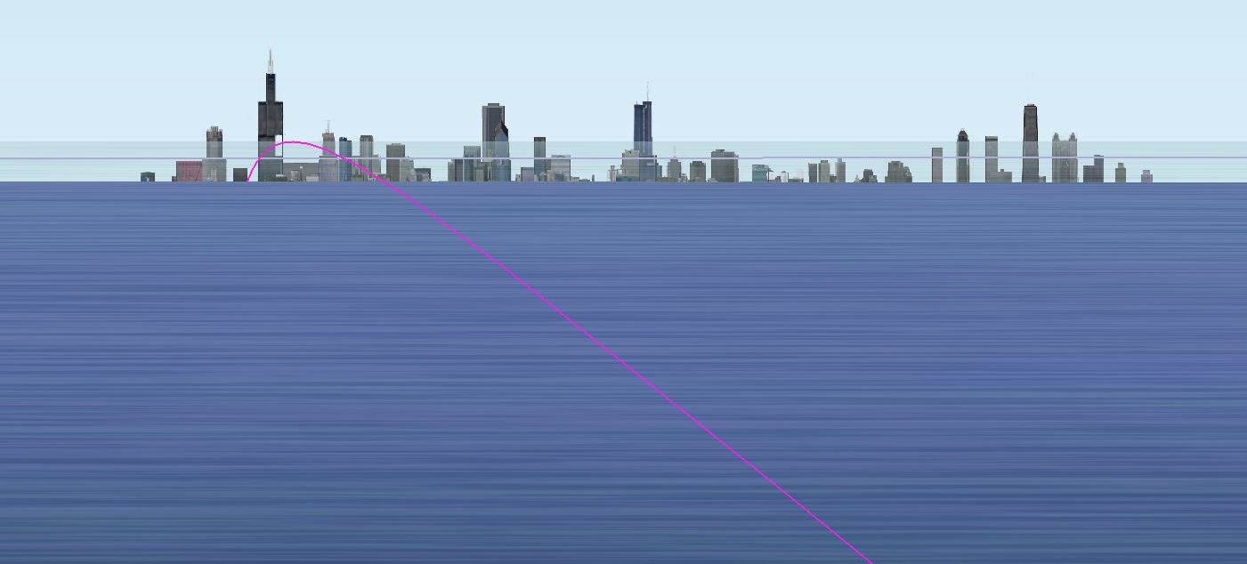
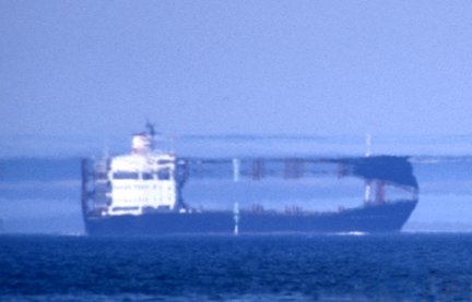
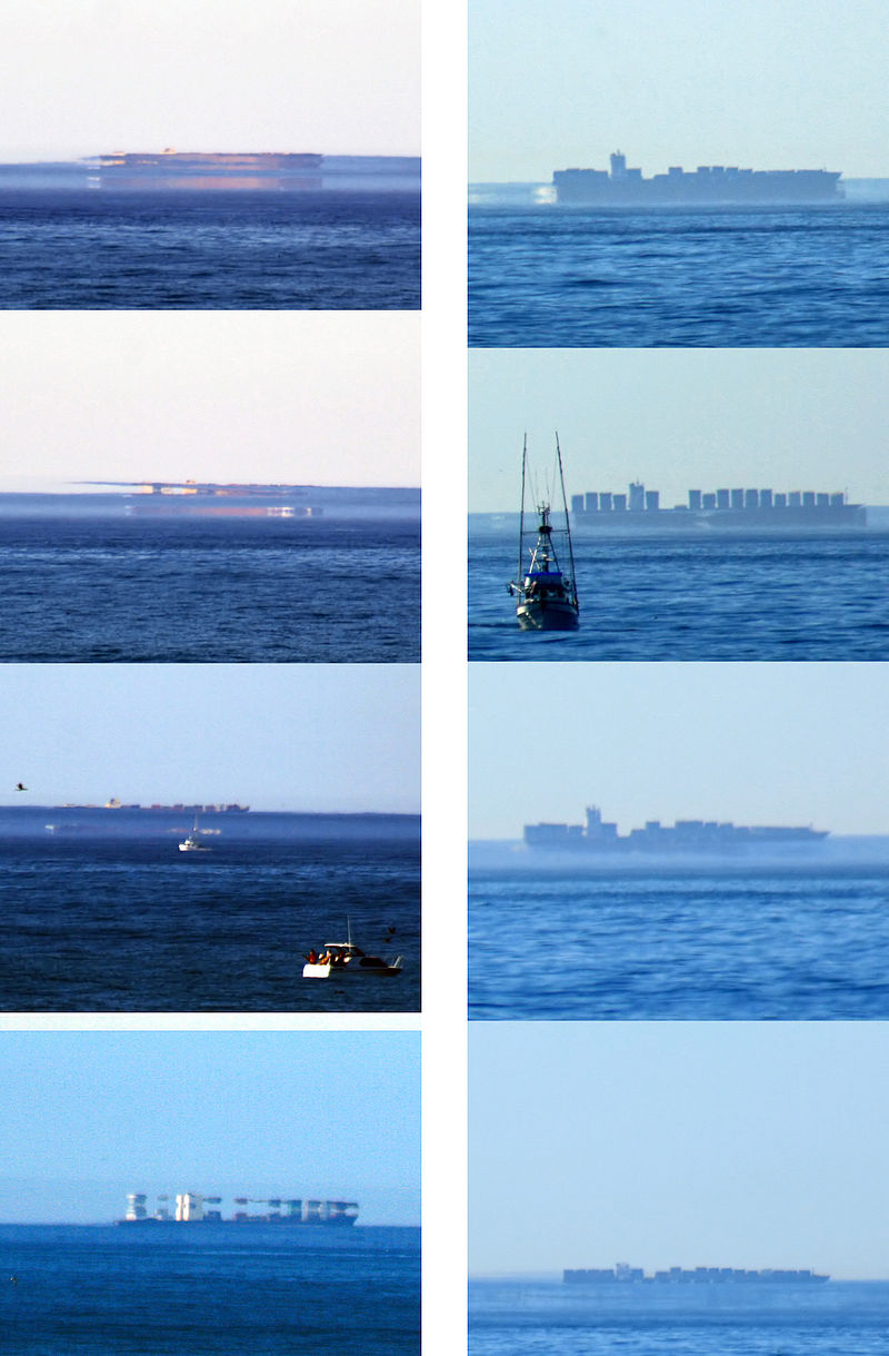
A Fata Morgana superior mirage of a ship can take many different forms. Even when the boat in the mirage does not seem to be suspended in the air, it still looks ghostly, and unusual, and what is even more important, it is ever-changing in its appearance. Sometimes a Fata Morgana causes a ship to appear to float inside the waves, at other times an inverted ship appears to sail above its real companion.

In fact, with a Fata Morgana it can be hard to say which individual segment of the mirage is real and which is not real: when a real ship is out of sight because it is below the horizon line, a Fata Morgana can cause the image of it to be elevated, and then everything which is seen by the observer is a mirage. On the other hand, if the real ship is still above the horizon, the image of it can be duplicated many times and elaborately distorted by a Fata Morgana.
Content from External Source

Along with sequences of photos showing how they change over time.
 
Last edited:
The above math actually gives a larger obscured portion for the OP setup though. 92.6 feet for a 45 high observer at 20 miles. (distance to horizon is 8.21 miles). Seems like they were simplifying. Not a significant difference though.
Greetings --

I find an alternative formulation of the equation useful, because it allows one to easily account for refraction. Instead of defining the chord distance "d" between the two (ground) points, define the line-of-sight distance "t" between the camera the target object. The "a", "x" and "r" variables are the same as in your diagram at https://www.metabunk.org/curve/.

Now let P be the point where the the line-of-sight is tangent to the earth (you have it marked with a dot in your diagram). Let t1 be the distance from the observer to P; and let t2 be the distance from the target object to P. This means t1+t2=t.

This means we now have two right triangles, each with a right angle at P. And if we assume that "a" is much less than r; and that "x" is much less than r, then we have, to a good approximation:

t1 = √((3/2 mi²/ft)*a)
t2 = √((3/2 mi²/ft)*x)

But this is assuming zero refraction. Various sources say that to account for "normal" refraction, the constant "3/2" should be replaced by "7/4". So for now, let us use the variable "k" as a placeholder:

t1 = √(ka)
t2 = √(kx)

Finally, combining that with t1+t2=t, and doing some algebra, we get, for the obscured height:

x = t(t-2√(ka))/k + a

Now we can plug in either k = 3/2 mi²/ft, or k = 7/4 mi²/ft, or some more suitable value, to account for refraction. (It's worth noting that when you set k=3/2 mi²/ft, the result is nealy identical to the answer obtained at https://www.metabunk.org/curve/ , since if "a" and "x" are much less than "r", then "t" is very nearly the same as "d".)
 
Last edited:
I spent a few days at sea. From the beach near Domburg (NL) I took a picture of windmills in the north sea, located between 36 and 45 km away. I added two scale drawings, for comparison; the height of a windmill was 94 m from sealevel to turbine; the blades had a lenght of 61 m.
upload_2016-2-13_21-15-42.png

First I was standing on the beach so I watched from a height of roughly 2 m. You can calculate -- taking into account the atmospheric refraction -- that the base of the windmills at 36 km should be roughly 63 m below the horizon.

Then I took a second picture from a high dune, close by, 24 m high.
upload_2016-2-13_21-14-4.png


Again I calculated how far the base should be below the horizon: roughly 20 m at a distance of 36 km
Three things can be concluded:
1. Windmills further away appear to be lower (like a ship sailing away from you)
2. From a higher standpoint you can see further away
3. The calculations are pretty nice consistent with the observations
 

Attachments

  • upload_2016-2-13_21-14-56.png
    upload_2016-2-13_21-14-56.png
    480.4 KB · Views: 444
I spent a few days at sea. From the beach near Domburg (NL) I took a picture of windmills in the north sea, located between 36 and 45 km away. I added two scale drawings, for comparison; the height of a windmill was 94 m from sealevel to turbine; the blades had a lenght of 61 m.
upload_2016-2-13_21-15-42.png

First I was standing on the beach so I watched from a height of roughly 2 m. You can calculate -- taking into account the atmospheric refraction -- that the base of the windmills at 36 km should be roughly 63 m below the horizon.

Then I took a second picture from a high dune, close by, 24 m high.
upload_2016-2-13_21-14-4.png


Again I calculated how far the base should be below the horizon: roughly 20 m at a distance of 36 km
Three things can be concluded:
1. Windmills further away appear to be lower (like a ship sailing away from you)
2. From a higher standpoint you can see further away
3. The calculations are pretty nice consistent with the observations

Wow. Are those things anchored to the sea floor or what?
 
Here is some more information about their location, construction and size
upload_2016-2-15_7-49-47.png
 

Attachments

  • upload_2016-2-15_7-51-39.png
    upload_2016-2-15_7-51-39.png
    342.6 KB · Views: 407
Finally if anyone would like to check the calculations:
upload_2016-2-15_10-2-50.png
Thanks for the reference (below) you provided which addresses refraction.
http://www-rohan.sdsu.edu/~aty/explain/atmos_refr/horizon.html
A simple "7/6 * R" adjustment is easy to include. It also makes more sense than one of the cited Youtube videos that suggests a constant (7%) linear adjustment. A fixed percentage implies a straight line, which is inconsistent with a curved geometry. I'll play with this a bit on a spreadsheet to better understand its effects.
Note: Your calculations look correct. There are more compact derivations that yield the same result by substituting the Pythagorean formula in place of the cosine and arccosine terms. See post #106.
 
As relates to flat earth models, consider the conflict demonstrated by sketching as follows;
Pick two cities far enough apart from each other such that when it's noon at one of them, it is midnight at the other. Draw a horizontal line using a scale of, say, 1 inch=1000 miles to represent the distance between them. If someone drives across the U.S., they cover about 3000 miles and 3 time zones. So a reasonable first approximation might be that a horizontal line 12 inches long represents the distance between 2 cities that are 12,000 miles and 12 time zones apart.

Next, draw a vertical line from one end of the horizontal line (i.e. the city where it's high noon) up to whatever distance the sun is believed to be from the earth. Clearly, if the sun is 93 million miles away, the sun will be at a high noon position for BOTH cities. In an attempt to address this conflict, flat earth believers suggest the sun is much closer, perhaps as close as 3000 miles away. Let's accommodate this model by making the vertical line a 3 inches long.

Lastly, draw a diagonal line from the top of the vertical line (i.e. the sun) to the other end of the horizontal line (i.e. the city where it is midnight). If the earth is assumed to be flat, that diagonal line represents the line-of-sight view of the sun as seen by the viewer at midnight. This trivially simple sketch of a right triangle demonstrates that REGARDLESS of the sun's distance from the earth, the sun will never set on a flat earth.
You are absolutely right. This is also clear from the thread https://www.metabunk.org/an-easy-ex...erving-the-size-of-the-sun.t7252/#post-178389
In the animation of Mick in the first post you can clearly see the sun not only shrinking, but also never setting. Flat earthers than usually throw in some magical "perspective".
I would like to add another mathematical contradiction within the flat earth model. As you said above in the FEM the sun is supposed to be say 3000 miles above the flat disk. But how high exactly? I will show that it is impossible to give one single height for the sun, given the fact that the latitude of a place on earth determines both the distance to the equator and the angle at which the sun is observed from that place.
Suppose it is noon at the time of the vernal equinox (20th of march); the sun is in the zenith for an observer at the equator. At the same time an observer at say 50° north at the same longitude sees the sun at noon 40° above the horizon. The distance to the equator is 69.4 miles for every degree. So the observer can calculate the height of the sun:
upload_2016-4-22_21-58-20.pngh = d.tan 40° = 2912 mi
But if you repeat this calculation for, say, a latitude of 30° north h will turn out to be 3606 mi; for 70° north h must be 1768 mi; from an observer on the north pole it must be zero. Every degree of latitude will give a different height.
The model fails mathematically
 
Back
Top