Debunked: Look-up.org.uk claims to find Gulf of Guinea Chemtrails base

Jay Reynolds

Senior Member.
The Claim:

goofus1a.jpg
goofus1a.jpg
goofus1b.jpg
goofus1.jpg
goofus2.jpg
Explanation:

The claim by Look-up.org.uk (Ian Simpson) is that when he is using the flight tracking site Flightradar24 he sometimes sees planes flying from South America to the UK seem to suddenly disappear off track and end up at a position in the Gulf of Guinea off the coast of West Africa. The track eventually reappears on it's normal scheduled route.

He believes that chemtrail material is being loaded on a "secret island" there and then the flight continues on to its destination where the chemtrail substance is unloaded for use at London Heathrow Airport.

He claims to have spent 25,000 British Pounds doing this research, but didn't bother to check the actual geographic coordinates of the "secret island" for anything unusual, because this is what he would have found:

goofus.jpg


Conclusion:

Flightradar gets its information from ground based ADS-B receivers which receive signals broadcast from the airplanes.
ADS-B sending units are not currently required to be carried on all flights, many do not have those units installed. Much of the feed that Flightradar24 gets comes from amateur hobbyists who have their own ADS-B receivers and put their receptions online for other hobbyists to use. Flightradar aggregates those feeds and offers them to the public.

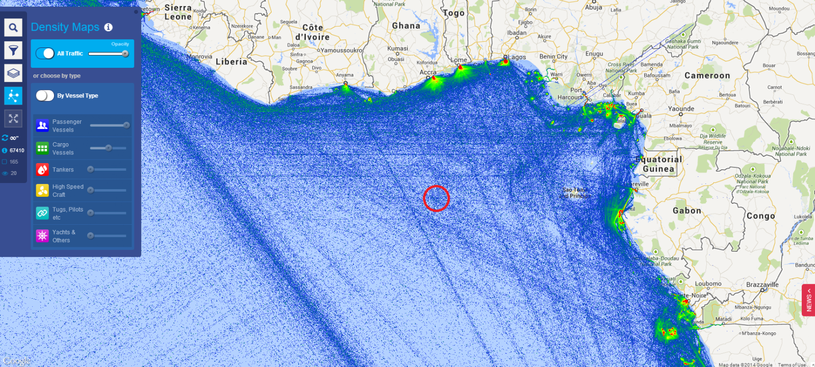
The range of ADS-B transmissions is only about 200 km, so once a plane gets over a sparsely populated area, or over oceans there is no ADS-B data received by Flightradar24. As a result, sometimes when a plane's ADS-B position is no longer being received, it sometimes defaults to 0 degrees Latitude and 0 degrees longitude, a single location on earth which just happens to be a spot in the sea off the West African coast in the Gulf of Guinea.

Sorry that you wasted all that money for nothing, Ian. I suppose it was someone else's money, right?

Are you going to tell them how you wasted it, or try and cover this one up too?

You should admit your mistakes, Ian, go lick your wounds and rethink things.
 
Last edited:
I am PCless but am I missing out on something? Are we to believe that the evidence produced for this secret island is Flghtradar24. One would have thought GoogleEarth would be a point of call (I can't do that) or checking Admiralty Charts for the Gulf of Guinea. If this is the quality of research been done it makes you wonder if supporters and donatees are getting value for money, especially given the claim that such evidence is going to be used in court.
 
All that page does is throw up claim after claim and say they have emails, lab tests, aircraft plans and emails to support these claims. I don't know if anyone is clicking on the Donate button but surely it can't take very long before anyone who does loses patience

Another claim is the Ian has quit his job and sold his house to pursue this. I can't help but hope that's true
 
Looks like the "secret island" also has a branch of the Hotel Singh Empire DX, according to Google Earth:
Hotel Singh.jpg


It's actually in New Dehli. Not too hard to understand how this sort of thing happens.
 
Just had a quick look at the lookup.org.uk website.
The quality of their "research" is incredible.
Apart form some random FR24 pictures that are supposed to prove something about Flybe being the biggest sprayers in the UK, in the Perpetrators section it mentions Jet2.

They had this to say: Not all are sprayers. Jet 2, for instance, we believe to be the delivery trucks that take the chemicals from one airport to another within the UK. All they seem to do is travel between UK airports at night. One could obviously argue that these are freight carriers, but DHL and others already run numerous similar flights.

Wikipedia on the other hand, mentions they operate from 8 UK bases but also , out of their 48 aircraft, 7 of them are 737-700QC aircraft which are Quick change to alternate between passenger and cargo and Jet2 have a contract with ROYAL MAIL to do mail flights at night.

Rather than do any real research, rather like the secret base in the Gulf of Guinea, I suspect they just extrapolate wildly and then claim they have proof of their ideas which they then don't actually show anybody.
So this secret island which happens to appear at 0 latitude and 0 longitude but doesn't appear on Google Maps for example, they have supposedly captured a Ryan Air plane there.
Do they mean they actually CAPTURED as in took over (hijacked) it? Or do they mean photographed it? If they photographed it, or the island , why have they not put the photo on their website?

Looking at Google maps, there are basically 4 islands in the Bay of Guinea, none near those co-ordinates exactly. 2 of these Islands are Sao Tome and Principe, that make up one nation, and the other 2, San Antonio de Pale and Bioko Island, are part of Equatorial Guinea. Bioko island has the largest airport, but seeing as how Malabo is the CAPITAL of Equatorial Guinea, I find it VERY hard to believe the US Military commandeered THAT island and relocated the islanders.

I also read on that website that THIS SITE, is a paid government disinfo site which features complex disinfo that LOOKS LIKE SCIENCE!!! :D
I lolled at that one.
 
No, tell a lie, there are also 4 other small tiny little islands that appear to have NOTHING on them, just South of Principe, and then a LOT further out, you of course have St Helena and Ascension Island.
Ascension Island does have an Air Strip, and some kind of US presence (or it did in 1982 when the RAF flew the Black Buck Missions to the Falklands from there) but as that is right in the middle of the ocean , halfway between Brazil and Gabon, that is still nowhere near where the FR24 data was pointing.
 
Also, interestingly, lookup claims Flybe are the worst offenders, mostly cos they regularly turn OFF their transponders.
This seems highly unlikely.
HOWEVER, if the owners of the site bothered to look up the HOW IT WORKS section of FR24, AND the list on Wikipedia of Flybe's fleet, they would find that NONE of Flybe's aircraft have an ADS-B transponder, and are therefore only visible on FR24 in the UK (which is outside the FAA radar data) when they are picked up with MLAT (which requires at least 4 FR24 receivers to pick it up, which usually means the aircraft needs to be at least 10,000ft-20,0000ft up in the air)
 
Look-Up still seem to be pushing their mythical island airstrip at 0 degrees latitude, 0 degrees longitude.

Capture.JPG

On this image the red dashed line shows the "filed flight path" on FR24. However if you look at the details (in the pink strip at the bottom here) then the "To" field is blank, hence the co-ordinates are, presumably, zero.

Capture.JPG

I thought this basic misconception had been explained to them?
 
Yes, here's another example:
http://www.flightradar24.com/data/airplanes/N738MA#41afcdd
20140819-141155-4rxv1.jpg

Again there is no destination in the data, so it defaults to 0,0. However you can see the plane actually flew to Greece and was tracked by ADS-B the whole way.

Here's another, the flight is actually from Beijing to Shanghai
http://www.flightradar24.com/data/airplanes/N887FD#417e427
20140819-141549-7m8v5.jpg

I found these by filtering FR24 for flight that are tracked only by N-Number:


Then click on the flight number in the sidebar to see if they have an segments missing a "From" or "To" airport.
 
In case people don't trust satellite images not to conceal a secret island at "zero-zero", you can see photos taken from the location on the Degree Confluence Project, a website which collects photos taken at the precise crossing points of lines of latitude and longitude.

The entry for 0° 0° shows that there is nothing but open sea in that location (there are two other "incomplete" visits listed which don't quite satisfy the site's stringent accuracy requirements).

pic1.jpg

The visitors dropped a sounding ball at the precise zero point, as located by GPS:

pic3.jpg

The ball took 20 minutes to reach the sea bed, indicating a depth of approximately 5,000 metres at this point.
 
A couple of contributors tried pointing this out to them on FB yesterday, very politely, and showing clearly that what they were seeing was FlightRadar24 showing plotted courses without start/end points, hence the "0,0" locations, and that the actual route one of the planes in question took terminated in a place called Bejaia.

The posts got deleted of course, and they got branded as shills in Look-Up's response:-

"OK clarification. There is an island or military base in the Gulf of Guinea. Nothing to do with Bejaia, that was just a distraction from a shill. The planes switch off at the coast and fly to this island, pick up and fly back. We have caught them many times. The image shows the airstrip clearly and the route to it. I hope that makes sense now. That island/base or whatever it is is the distribution hub or maybe even where the chemicals are manufactured. As always the shill-ometer is a valuable tool. The more they squeal the more important the information, and my ears are ringing haha !"
Content from External Source
Even putting aside that they've ignored the evidence, are lying by omission, and that there's actually no airstrip there, what do they think the logic is behind putting a "distribution hub" out in the middle of nowhere then having planes make roundtrips of thousands of miles off course to visit it?

Ray Von
 
A couple of contributors tried pointing this out to them on FB yesterday, very politely, and showing clearly that what they were seeing was FlightRadar24 showing plotted courses without start/end points, hence the "0,0" locations, and that the actual route one of the planes in question took terminated in a place called Bejaia.

Actually I don't think the plane landed in Bejaia, as the altitude was still at 32,000ft when the track ended. The plane presumably moved out of range, as I doubt there are many ADS-B receivers in the Sahara! It might have been heading to Lagos, which is one of the airports used by Nordic Global Airlines, the sister company of Western Global: http://en.wikipedia.org/wiki/Nordic_Global_Airlines

It is unfortunate that the aircraft in question has its tracking set to "private", which helps to bolster such conspiracy theories.
 
Back
Top