Claim BUK launcher trucked out of Ukraine

Why do you think that there is only ONE Buk Telar?
There are posting that the separist catured about 20 Buks and 9 Radar. If the posting are correct , i don´t really know.
http://kp.ua/politics/460630-hpu-po...ache-voennoi-chasty-y-khymzavoda-opolchentsam
Recall that according to the militia, they counted on the territory of an anti-aircraft regiment of at least 20 air defense missile systems "Buk" and 9 mobile radar "the Dome."
http://vk.com/wall-35276355_245815

Yes - but that is the only source for that claim - it was not claimed at the time - Kiev only acknowledged the loss of one unserviceable launcher vehicle IIRC.

It will take some more evidence for some sort of reliable picture to emerge about this.
 
We know four Buks at 17.July. One at Luhansk (the missing Rocket), one on the Way from Donesk to Snizche and two on the Sat Pics (if the pic is true, at 17. there was very cloudy)
 
We know four Buks at 17.July. One at Luhansk (the missing Rocket), one on the Way from Donesk to Snizche and two on the Sat Pics (if the pic is true, at 17. there was very cloudy)

Seems you already decided that the BUK in Luhansk (second video) and the BUK in Snizche (first video) are different, which would fall in category (2) of my assessment.

Based on which evidence did you decide so ?

Also, you mention "two on the Sat Pics". Can you elaborate ?
 
The two Buks on the Sat Pic (5) are from the Russian Press Briefing http://www.mid.ru/brp_4.nsf/0/ECD62987D4816CA344257D1D00251C76

Since all of the evidence presented by the Russian Defense Ministry press conference on July 21 has been debunked (here on metabunk, and on other sites) I'm not sure why you would still bring up their findings.

But just in case, here is that satellite image from the Russian Defense Ministry that shows an addition 2 or 3 buks (from RT) :

http://rt.com/files/news/2a/94/c0/00/snimok_ekrana_2014-07-21_v_18.47.57.png

Isn't there something peculiar about the shadows these BUKs cast ?
 
In fact, this conversation between informant "Naimanets" (which means something like "hired hand") and commander Igor Bezler seems to sustain that theory :

What is the source of this recording? do we have an independent evidence that the speakers are who they claim them to be?

Rhetorical questions.

It's from the same Ukrainian secret service as the earlier one claiming "we shot it" which has been shown to be 4 conversations stitched together (again with no firm ID on participants). The same secret service that is trying to pin it on Russia. The same secret serviced which since then has claimed to see 100+ Russian tanks which the Defence service then claimed to destroy, without a SINGLE image anywhere for any of it. The same secret service which had a "Russian master" telling off a separatist for publishing the "we shot it" twitter a day too early.... when the "too early" was only a internet allegation based on wrong dates recorded by the site as proven by this very site Metabunk. The same which is claiming rebels are dressing up as Ukrainian soldiers to bomb their own villages since the ceasefire, to make the government look bad. The same claiming Russia used 2 nuclear warheads on Luhansk airport.

I would not trust this lot if they told me the sky is blue. And if they showed evidence I'd have it checked out for Photoshopping.

There are posting that the separist catured about 20 Buks and 9 Radar. If the posting are correct , i don´t really know.
http://kp.ua/politics/460630-hpu-po...ache-voennoi-chasty-y-khymzavoda-opolchentsam
A Ukrainian site quoting the Ukrainian Government. It says a commander (one of theirs) is being investigated for not defending his base sufficiently. They are implying but not openly stating there were 20 BUKS in that depot. It is unlikely that there were -- more likely 20 in the whole south-eastern territory.

The report is dated July 8 (rebels had claimed a BUK capture on June 26, confirmed by reports in Russian media, of course possibly propaganda).

July 17 what happened? UKRAINE claimed the separatists did NOT have a BUK, and if they did (from the above capture) it was a non-working partial unit. Therefore they could not have done the shoot-down unless they (a) got that fixed by the Russians or (b) were lent one by the Russians). RUSSIA claimed the separatists did not have one from them, for sure, nor did they fix one for them. LUHANSK separatist leadership said the separatists did not have one... but the ones who supposedly had it were in the Donetsk region, and those 2 separatist areas TO THIS DAY have separate military commands.

Russia, Ukraine and the USA ALL pointed to the SAME series of "BUK sighting" videos to prove their own side of the story. There were way too many such videos, including some going through government held territory, not likely for separatists or Russian ones to be carted around there in broad day light with "HEY LOOK AT ME I HAVE A MISSILE MISSING" screaming from them.

The white Volvo company's enormous phone number was conveniently left on the low loader, so the "owner" was eventually traced, to claim his truck had been stolen by separatists; source? the one and only piece of "investigative journalism" by a web site from Lithuania, currently the most anti-Russian country in the world.

This whole war is being fought in propaganda, as well as on the ground. Both sides have a motive to exaggerate the excesses and atrocities of the other side. I tend to believe whichever side produces video evidence of their claims, currently predominantly the separatists. Of course their stuff doesn't make it into mainstream western media.

But MH17 has been used by Ukraine and the USA to foment hatred against Russia,the former to try getting more military help, the latter to strengthen the sanctions against them. Russia has to try blaming Ukraine, as it is easier to pin the blame on someone else than prove your own innocence, especially as negatives are so hard to prove. So there are exaggerations and outright lies on all sides. You can't take any of it as being true. So it will continue to be confusing and not making sense. You can't determine the "truth" from any of it.
 
What is the source of this recording? do we have an independent evidence that the speakers are who they claim them to be?

Rhetorical questions.

It's from the same Ukrainian secret service as the earlier one claiming "we shot it" which has been shown to be 4 conversations stitched together (again with no firm ID on participants). The same secret service that is trying to pin it on Russia. The same secret serviced which since then has claimed to see 100+ Russian tanks which the Defence service then claimed to destroy, without a SINGLE image anywhere for any of it. The same secret service which had a "Russian master" telling off a separatist for publishing the "we shot it" twitter a day too early.... when the "too early" was only a internet allegation based on wrong dates recorded by the site as proven by this very site Metabunk. The same which is claiming rebels are dressing up as Ukrainian soldiers to bomb their own villages since the ceasefire, to make the government look bad. The same claiming Russia used 2 nuclear warheads on Luhansk airport.

I call this a Gish Gallop.
Seriously, KAT, the recording I posted lasts only 20 sec.
Can you debunk it's authenticity ? Did Bezler claim it did not occur ? Or did not occur at that time ?
If not, then the evidence stands.
That's how the scientific method works.
 
Can you debunk it's authenticity ? Did Bezler claim it did not occur ? Or did not occur at that time ?
If not, then the evidence stands.
That's how the scientific method works.

I see. So now anyone can put anything on youtube and it counts as hard scientific evidence, does it?
And let's say Bezler denied it. That would not be debunking, that would be a "he said she said" argument.
How about YOU provide some provenance to show the possible or likely accuracy of what you are stating?
THEN you still need to provide evidence Bezler was anywhere near where he can give an order to shoot that plane, otherwise being "tipped off" is of no value. Wouldn't it make more sense for the "spotter" to tip off the guy with the actual missile????

Why did they, after they realized that they downed a civilian airliner, not simply drive from Shnizhne across the Russian border ? That's only 5 miles. Why drive this BUK back to Shnizhne, load it on that white truck, forget to put a net over the top, then drive back to Donetsk, or find another way north through to highway M04, then drive M04 all the way to Luhansk, and take a right onto the ringway (Pavlivska St) only to be videotaped at that intersection ?

Ahhh NOW you're starting to get it. The smart thing to do would be to lie low and not move it about to be seen, for a few days. So the videos are (a) NOT the one that did the shooting or (b) taken on different dates. Either way, no evidence at all for likely location of the one that DID do the shooting. Red herring in other words.
 
July 17 what happened? UKRAINE claimed the separatists did NOT have a BUK, and if they did (from the above capture) it was a non-working partial unit. Therefore they could not have done the shoot-down unless they (a) got that fixed by the Russians or (b) were lent one by the Russians).

you seem to ignore the myriad of other possibilities - that the various claims you are referring to were not accurate is an obvious possibility.
 
It has gotten a bit quite on this thread (and most other threads on MH17 here on metabunk), but there are a couple of issues with the evidence that we have at hand that are simply begging for clarification and verification.

First one is directly about the video of the BUK that was taped in Luhansk, allegedly trucked out of Ukraine, with at least one missile missing. Here it is again :


This video was released on the morning of the 18th of July, and allegedly taped at 4:30 in the morning of the 18th, thus before sunrise.

We know now that it was taped on an intersection in Luhansk (an area under pro-Russian "rebel" control) driving south-east.

If you look at the light on this video, was it dawn, or dusk ?
And next, was there overcast or clear sky ?

These are VERY important question to answer, if we are to find out the truth about what happened before and what happened after MH17 went down.

Looking at the scene, here are my thoughts :
(1) this video was taken at dawn. At dusk, light would mostly come from the north-west, and thus the sky would have been darker than the scene.

It seems to me that if this was taken before sunrise under a cloudy sky, that there would not have been enough light to see so many details (remember there is no artificial light around on this scene).

which leaves the following two options :
(2) this video was taken before sunrise with clear sky, OR
(3) this video was taken under solid overcast skies after sunrise.

In my opinion, the light before dawn (with clear sky) is rather 'blue'ish, because Rayleigh scattering in the stratosphere is the only light source, and water vapor levels are low.

And light after dawn, through the clouds should have a more even spectrum (grey).

Now note that in this video, the colors that are green-blue-ish (like the edge of the billboard) stand out (you actually see the color), while areas that are 'red-ish' (like the roof in on the shed in the background) show up darker.

Thus, I'd like to conclude that this video was taken pre-dawn (probably 4:30 sounds right) but under a clear sky.

Since July 18th, Lugansk weather had solid cloud cover, I would like to assert that this video was NOT taken on the morning of the 18th, but on on a prior morning. Thus BEFORE it showed up in Donetsk and Snizhne, and BEFORE MH17 went down.

Please debunk this theory.

I do not know much about different light under different circumstances, so it would be GREAT if somebody like a professional photographer could comment here.
 
Thus, I'd like to conclude that this video was taken pre-dawn (probably 4:30 sounds right) but under a clear sky.

As a young boy I was a trucker and started my day at 4:00-6:00. At the depot I had a good view to east. Though being +1000km more north the sky in the video is definitively an early summer sky. Yes, there's no cumulus clouds because those clouds form up later in the day - the morning's are "grey" as in the video. You can't tell the day sky and clouds in the mornig.
 
This video was released on the morning of the 18th of July, and allegedly taped at 4:30 in the morning of the 18th, thus before sunrise.

We know now that it was taped on an intersection in Luhansk (an area under pro-Russian "rebel" control) driving south-east.

If you look at the light on this video, was it dawn, or dusk ?
And next, was there overcast or clear sky ?

These are VERY important question to answer, if we are to find out the truth about what happened before and what happened after MH17 went down.

Looking at the scene, here are my thoughts :
(1) this video was taken at dawn. At dusk, light would mostly come from the north-west, and thus the sky would have been darker than the scene.

It seems to me that if this was taken before sunrise under a cloudy sky, that there would not have been enough light to see so many details (remember there is no artificial light around on this scene).

which leaves the following two options :
(2) this video was taken before sunrise with clear sky, OR
(3) this video was taken under solid overcast skies after sunrise.

In my opinion, the light before dawn (with clear sky) is rather 'blue'ish, because Rayleigh scattering in the stratosphere is the only light source, and water vapor levels are low.

And light after dawn, through the clouds should have a more even spectrum (grey).
According to TimeAndDate.com sunrise in Luhansk on the 18th July was 4:40am, so assuming the 4:30 timestamp is anywhere near accurate it'd be just before sunrise and likely well past dawn. I can't find any concrete information on how long dawn to sunrise takes in that area at that time of year (using the definition of "dawn" as when the sun starts to provide light without rising above the horizon).

I wouldn't say the lighting in the video looks unusual for that time of day. I'm regularly out with the dog through dawn and sunrise, and if it's overcast the sky often appears grey until the sun comes over the horizon, and the sky in the video looks grey, perhaps even pink-grey.

That second paragraph is just an observation in case it helps, I'm not claiming evidence :)

Ray Von

*Edit* - This chart has dawn and sunrise times for Luhansk. Unfortunately the approximate times only run for six months and the chart doesn't really allow for accuracy. In the data available dawn to sunrise is +-30 minutes, and the chart looks like it peaks in July but it could just be how the chart is drawn.
 
Last edited:
Thats guys, for you feedback !

To determine sunrise/sunset and solar angles (azimuth and elevation) at any time and any place on Earth, I found the NOAA solar calculator quite helpful :

http://www.esrl.noaa.gov/gmd/grad/solcalc/

The location of this scene in Luhansk is 48.54536 N and 39.2648958 E.
Enter that data and +3 timezone (Ukraine time in summer is GMT +3) for July 18th, you get apparent sunrise at 4:40 am.

So this scene was apparently filmed some 20 min before sunrise.
The question is : is there any way in which we can determine without ambiguity if there was there solid overcast or clear sky.

Does anyone have pictures of a scene with multiple colored objects in it, taken 20 min before sunrise, under clear-sky conditions and under overcast conditions ?
 
I can only add July 16 was a very clear day -- satellite images on Google Earth from that day have no cloud in them at all (don't know what time they were taken but it is daylight). July 17 was so cloudy they showed nothing, so Google didn't even provide them. It rained lightly a few times after the plane crashed, not hard enough to put out the fire. July 18 was scattered cloud and showers.


In preceding days, they shot down an Antonov transport on July 14, and on July 16 they claimed two Su-25 support planes, but the Government said only one of those crashed, the other was able to land. It was rarely stated what weapon they were shot with, not too relevant in wartime, although they were assumed to be shoulder mounted mobile rockets, as most were shot down at fairly low altitudes (eg coming in to land or drop something).
 
The Terra & Aqua images for this area on 17 Juky are available here - I'm sure someone can figure out what local time they are at from converting the metadata from UTC......it is possible to get the time of the individual swathes that make up the composite images if you're really keen - there is quite a lot of cloud around but I am not sure exactly where & when.
 
The Terra & Aqua images for this area on 17 July are available here - I'm sure someone can figure out what local time they are at from converting the metadata from UTC......it is possible to get the time of the individual swathes that make up the composite images if you're really keen - there is quite a lot of cloud around but I am not sure exactly where & when.

The Terra image (of the Donbas area) is from 08:10 UTC swath, the Aqua image is from 09:55 UTC swath. The local time was UTC +3h.

There was no complete cloud cover other the crash area at the times.
 
Last edited:
It was rarely stated what weapon they were shot with, not too relevant in wartime

For the Su-25's the militia just said 'Portable anti-aircraft defence system', it isn't real clear if they mean portable SAM or MANPAD.

For the AN-26 the separatists were pretty vocal about how they took it down:

Vzgylad July 14th - 'Ukrainian military claimed that the losses were caused by the actions on the part of Russia. The militia has denied this information, adding that downed plane from SAM "9K37M1" (better known as the "Book").'

Politikus July 14th - Rebels state they, not Russia, who downed AN-26 using captured BUK
 
Aqua/Terra imaging is best viewed in NASA WorldView, since it not only projects the images on a plane, but also adds city/border and other masks.

I uploaded two screenshots of the Donbass area from Aqua/Terra in WorldView, focused in on Donbass :

(1) The last swath from July 17 (by Aqua), which happened 11:35 UTC, or 14:35 local time, thus about two hours before MH17 crash), and

(2) The first swath on July 18 (by Terra), which happened 8:55 UTC, or about noon on the 18th.

These shots clearly show that clouds were moving in from the South-West during the 17th, and by the 18th Lugansk (as well as the rest of Donbass) was covered in solid clouds.

So the question remains :
Is there any way in which we can determine without ambiguity if there was there solid overcast or clear sky in the video above ? (allegedly taken 20 min before sunrise on the 18th, in Lugansk).
 

Attachments

  • Screen Shot 2014-10-05 at 12.05.00 AM.png
    Screen Shot 2014-10-05 at 12.05.00 AM.png
    783.1 KB · Views: 665
  • Screen Shot 2014-10-04 at 11.57.45 PM.png
    Screen Shot 2014-10-04 at 11.57.45 PM.png
    313.9 KB · Views: 596
Aqua/Terra imaging is best viewed in NASA WorldView, since it not only projects the images on a plane, but also adds city/border and other masks.

I uploaded two screenshots of the Donbass area from Aqua/Terra in WorldView, focused in on Donbass :

(1) The last swath from July 17 (by Aqua), which happened 11:35 UTC, or 14:35 local time, thus about two hours before MH17 crash), and

(2) The first swath on July 18 (by Terra), which happened 8:55 UTC, or about noon on the 18th.

These shots clearly show that clouds were moving in from the South-West during the 17th, and by the 18th Lugansk (as well as the rest of Donbass) was covered in solid clouds.

So the question remains :
Is there any way in which we can determine without ambiguity if there was there solid overcast or clear sky in the video above ? (allegedly taken 20 min before sunrise on the 18th, in Lugansk).

NASA WorldView is a convenient tool, but one also can display the MODIS images on Google Earth using associated KMZ files.

In general, there is only one image of a particular area per the (Terra or Aqua) satellite per day. The two images happen only if the area lays at the edges of two overlapping swaths, separated by ~90 minutes. It was not the case for the Aqua image of Donbas area on July 17; the 11:30 UTC swath just missed it:
http://lance-modis.eosdis.nasa.gov/...fl2_143.A2014198113000-2014198113500.250m.jpg
The Aqua image you uploaded is from 09:55 UTC swath.

The Terra swath on July 18 is indeed at 08:55.

I am sceptical about the extrapolations of cloud movement and cover between the two times. I used to live in that area and recall that, due to vicinity of the inland sea, in hot summer days clouds tend to form quickly at midday and dissolve later.
 
Last edited:
Trainspotter, you are correct that the last swath on July 17 was at 9:55 UTC (more than 3 hours before the MH17 crash) by Aqua, and the first swath on July 18 is by Terra, at 8:55 UTC.

Still, since the swaths of Aqua and Terra overlap 50% in the Ukraine area, there are TWO images for each day.
Thus, we now have 2 images for July 17 and 2 for July 18, as you can see by selecting the data and the satellite in the WordView link :

July 17, 8:12 UTC, Terra : mostly clear skies above all of East Ukraine, scattered clouds in Donesk area.
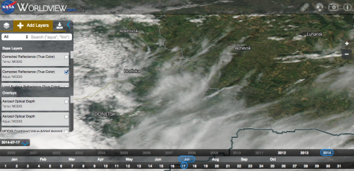
July 17, 9:55 UTC, Aqua : (screenshot 1 above) mixed level clouds around Donesk, Lugansk scattered clouds.
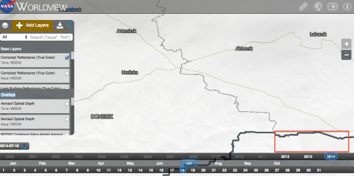
July 18, 8:55 UTC, Terra : (screenshot 2 above) solid cloud cover all around east Ukraine.
July 18, 10:40 UTC, Aqua : solid cloud cover all around Ukraine.

I understand your point that in order to find cloud cover during daybreak on July 18, we should not extrapolate (interpolate actually) cloud cover the pictures from July 17, 9:55 UTC, Aqua and July 18, 8:55 UTC, Terra.

But there are other satellite pictures around, so we do not have to interpolate.

For example, there is MeteoSat, in geostationary position, which takes visible light and IR images which are released here an hourly basis :

http://www.sat24.com/history.aspx

East Ukraine is in on the far right in these images.
Set the time and date, and notice that during the morning of July 17, Eastern Ukraine was mostly cloud free, with clouds moving in from the South West during the day, which turned to solid cloud cover as July 18th started (even in IR; which means these clouds are thick), and even got thicker during the course of July 18th, only to slowly dissipate during the 19th.

This shows that the morning of the 18th, Lugansk has solid overcast, while the morning of the 17th Lugansk had clear skies. Does that make sense ?
 
http://dip21.bundestag.de/dip21/btd/18/025/1802521.pdf

According to this memorandum published on the website of the bundestag, 2 AWACS monitored the region and monitored MH-17 both by radar and transponder until out of range. They also picked up a signal automatically identified as an SA-3.

Die AWACS erfassten in ihrem Auffassungsbereich Signale von einem Flugab- wehrraketensystem sowie ein weiteres durch AWACS nicht zuzuordnendes Radarsignal. Das Flugabwehrsystem wurde durch AWACS automatisiert als „Surface to Air-Missile“ SA-3 klassifiziert, ein in der gesamten Region routine- mäßig erfasstes Signal.
Content from External Source

The SA-3 reference is likely down to initial automatic analysis from the E-3. The system assigns the signal a classification of SA-3. A more dedicated ELINT aircraft platform such as RC-135 would process the signal further with input from on board analysts. SA-3 and SA-11 are claimed to have same/similar wavelengths.

Yes Fire Dome (9S35M1 of SA-11, search mode) and Low Blow (fire and tracking channels of SA-3) have same wave length - 3cm.
Content from External Source
http://www.pprune.org/rumours-news/543733-mh17-down-near-donetsk-66.html#post8655506

http://www.pprune.org/rumours-news/543733-mh17-down-near-donetsk-66.html#post8656350
 
The AWACS mentioned by the German source would have been the ones taking part in NATO exercises in the vicinity of Romania. The USA had an RC-135 operating in the area a few days later, quite possibly also during that NATO exercise. They didn't say so when they first claimed to have "seen signals" indicating a BUK being fired, but a few days later one got chased into Swedish air space by threatening-looking Russian MIGs. At the time they were implying the signals were "seen" by satellites.

However, no traces or print-outs of these signals were ever published, nor would probably any of us recognise one if we saw one. So it's a "take our word for it" situation.
http://www.reuters.com/article/2014/07/17/us-nato-romania-drills-idUSKBN0FM1I020140717
The Romanian Navy said exercises involved commercial traffic monitoring, reaction to asymmetric threat warnings, anti-submarine warfare and artillery firing.
Content from External Source
 
AWACS have great radar detection ability, but you won't get a "picture" in the traditional sense from these aircrafts' radar analyses.

Angular resolution of a 10 meter synthetic aperture antenna would give you about 3 km angular resolution at 1000 km distance. That is enough to determine a "line" (direction) of where a radar signal came from, but since the altitude over distance of a plane flying 1000 km away is very low, the "depth" (distance) resolution of a single AWACS plane would be piss poor, even in theory (in the hundreds of km's range).

So, you would need two (or three) AWACS readings to determine the place of origin of launch by triangulation with km type of accuracy.

Either way, the radar detection methods of AWACS do not resemble anything close to a "picture" in the traditional sense, and the same thing is true for satellite radar detection systems like ALINT, and thus, yes, when the Pentagon tells us that there was a launch from Snizhne, you kind of have to take them at their word.

Just remember that there was a LOT on work involved (and double, and tripple checking, using multiple detection methods) for them to come to that conclusion.

If you question the Pentagon data, then that is OK. Just remember that the scientific method cannot prove any statement to be right. It can only prove a statement to be wrong.
 
when the Pentagon tells us that there was a launch from Snizhne, you kind of have to take them at their word.

Just remember that there was a LOT on work involved (and double, and tripple checking, using multiple detection methods) for them to come to that conclusion.

I am sure AWACS have great capabilities. But we also have to take their word for it that they actually did do those calculations and actually did get those results. This is not an issue of AWACS technology. It is an issue of the credibility of the AWACS owners, who, luckily/conveniently for them, never have to show their "high tech national secret" data sources.

So we do not actually have any AWACS data, we just have someone saying they had some. From the same Government that was snarling about "bodies left to rot in the fields" at the same time that there were miles of TV footage showing the exact opposite -- bodies being searched for and found and picked up.
 
So we do not actually have any AWACS data, we just have someone saying they had some. From the same Government that was snarling about "bodies left to rot in the fields" at the same time that there were miles of TV footage showing the exact opposite -- bodies being searched for and found and picked up.

KAT, why the red herrings ?

If you do not believe the Pentagon's statement that there was a SA-11 launch from Snizhne on the 17th of July right before MH-17 went down, then just tell us that there was no launch at all, or the launch was from a different site, or at a different time.

That would help.
 
There is an article in Der Spiegel,

http://www.spiegel.de/international...an-separatists-for-mh17-downing-a-997972.html

which mentions :

“The BND has intelligence indicating that pro-Russian separatists captured a BUK air defense missile system at a Ukrainian military base and fired a missile on July 17 that exploded in direct proximity to the Malaysian aircraft, which had been carrying 298 people.”

This appears to imply that the BUK that shot down MH17 came from a Ukrainian airbase. But note that that is not EXPLICITLY stated.

If the BUK DID come from a Ukrainian airbase (possibly BUK 112 on the picture released by the rebels on June 29) then this information creates more questions than it answers. For example, is the BUK on the ParisMatch picture in Donetsk the same as this ‘captured’ Ukrainian BUK, and if so, what was it doing in Starvy Oskol on June 23 ? And if it is NOT the same BUK as the German intelligence report mentions, then there were TWO BUKs in Donesk area on July 17, which raises a whole set of new questions.

On the other hand, if the German report did NOT state that the BUK captured from a Ukrainian base was the one that shot down MH17, then the question is why Der Spiegel put the two statements in one sentence.

Does anyone have a copy of that German intelligence report, or a copy of the slides form the Oct. 8 presentation given to members of the parliamentary control committee ?
 
Mike, the previous comment (regarding a new German intelligence report on MH17) should really go into the "flight MH17 News" thread.

But that one appears to be closed to new comments.
Why ?
 
Thats what the "Spiegel" told us is a summery of the Details that was told by the BND at 8.October. There are no Details yet.
Kiew told that only one, not working Buk, was captured from the A-1402 at 29.June. They also told at 17.July that the separist don´t have a working Buk. Here is the A-1402 located 48°3'37"N 37°44'28"E. Google Earth Dat 3.September 2014.
There is also this http://kp.ua/politics/460630-hpu-po...ache-voennoi-chasty-y-khymzavoda-opolchentsam

Here is the A-1428 located, known from the Press Briefing Sat Pic 48°5'53"N 37°45'17"E
Compare the Sat Pic 2 and 4 of Press Briefing with the Google Eart Date 03.September.2014
http://www.mid.ru/brp_4.nsf/0/ECD62987D4816CA344257D1D00251C76
 
Thats what the "Spiegel" told us is a summery of the Details that was told by the BND at 8.October. There are no Details yet.
Kiew told that only one, not working Buk, was captured from the A-1402 at 29.June. They also told at 17.July that the separist don´t have a working Buk. Here is the A-1402 located 48°3'37"N 37°44'28"E. Google Earth Dat 3.September 2014.

Thanks triumph.
Do you have the link to a statement from Kiev that "one, not working Buk, was captured from the A-1402 at 29.June" ?

There is also this http://kp.ua/politics/460630-hpu-po...ache-voennoi-chasty-y-khymzavoda-opolchentsam

Here is the A-1428 located, known from the Press Briefing Sat Pic 48°5'53"N 37°45'17"E
Compare the Sat Pic 2 and 4 of Press Briefing with the Google Eart Date 03.September.2014
http://www.mid.ru/brp_4.nsf/0/ECD62987D4816CA344257D1D00251C76

For clarity, that is airbase A-1428, which was the rebels never controlled.
And yes, there is a BUK visible there, with its launcher-part at a 45 degree angle.

Google history of this same base shows that it has been standing there for a long time (since May 28) and it is still there today :

http://2.bp.blogspot.com/-YsY7O2GynFI/VEQuefJHWJI/AAAAAAAAWis/URhaO2Q1fZM/s1600/BUK+16.JPG

In fact, a recent picture of this BUK emerged (uploaded Aug 8), which shows this thing up-close and personal :

http://4.bp.blogspot.com/-wezTwN6R-Ek/VEVVQXQWikI/AAAAAAAAWlA/8O4LJVio6pg/s1600/v3qmBIluNFw.jpg

By the looks of it, that thing has not moved in a long time.
 
Yes it is A-1428 north of the Airport. This Base was attact 2-times but not capured. The Buk looks like another Truck or something else hit the Buk at the top. So it is clear that Russian manipulated the Sat Pic of the missing Buk at the Press Briefing. The Buk was all time placed at this point.
There are different Statement of the A-1402. Kiew Staement is: Yes it is been capured but only one not working Buk is capured. Here is a Staement of Pro Russia. One interesting Sentence "On the question of whether the militants to bring him in martial status, Dmitrashkovsky replied: "I do not think they need it."
http://podrobnosti.ua/accidents/2014/06/29/982627.html
http://www.interfax.com/newsinf.asp?id=517080
But, when you open Google Earth, no Buk is seen at the place, only a lot of Trucks. It is a bit mistery.
When you compare the Google Pics, only 2-3 Cars/Truck was moved between 19.June and 21.July
 
I noted the following posted on another forum. He is looking for feedback on his analysis. I've already informed him that Metabunk is the best place to post his theory and to receive feedback and analysis. Hopefully he will join the discussion?

Herewith his claims, videos and analysis.

upload_2014-12-9_13-42-28.png


Regarding the separatists stolen truck I was immediately sceptical of the Luhanssk video put out by the SBU, it just didn't look right.

As a lorry driver with 20 years experience (including low loaders) my first thought was it didn't look loaded right (too far forward) and if the video was taken by Ukrainian security services why such crappy resolution video ?

Why would the Separatists risk running around in daylight using the same truck if they had just shot down a civilian airliner?

After much searching round and looking at other pictures of the truck I noticed something else, the handrail on the back of the cab seems to move around? (see image)

Then to the picture quoted above uploaded anonymously on August 6th, it is my belief it was photoshopped into a screen grab from a video uploaded on June 12th, see my video here,
Content from External Source


I could be wrong, but from comparing to other trucks on Google images it looks like a Volvo FH12, without fairings.

The airline rig on the back of all the FH12's I can find don't resemble what he describes as a handrail/airbrake bracket - they're lower down and seem to be flat against the back of the cab. Here's one for sale on eBay, along with some examples

FH Airline Bracket


[Broken External Image]:http://[url="http://"]


http://[b

It could have been modified or a different version, or maybe it's actually a trolley or something which isn't fixed to the cab.

As far as the side markings go, a couple of the pictures are too low res to tell either way for my money.

Ray Von[/URL]
 
The picture with the truck was clearly taken from the same camera location, but I don't see any evidence that it was created from the same video. The lighting is totally different (and looks consistent to me) and the vegetation is also different.
 

I`d like to pay attention to couple of details.
Street-lamp, fog-smoke and bird.
Street-lamp behind right edge of the billboard is online but the location is rather good lighted by nature light. Such often happens before sunrise like this
Fog-smoke at separated location visible behind the bottom right side of the billboard. It can be smth like a morning mist or maybe stagnated smoke while it is windless.
Bird at last seconds. I think the bird is already awaked according to its biological rhytmes. I don`t know exactly maybe it is some kind of nocturnal bird and it didn`t fall on sleep yet.
 
Back
Top