A Side View of the Curvature of the Earth at Lake Pontchartrain

I don't think Soundly ever claimed to be showing the curvature of the horizon as such. This would surely not be detectable from such a low viewpoint. If anyone wants to stipulate by definition that 'side-to-side' curvature can only mean the curvature of the horizon, then by that definition the video does not show side-to-side curvature. But it seems very odd to call it 'head-on' curvature when the viewpoint is opposite the centre of the line of towers, at a distance of about 4 miles, and the camera pans from side-to side along them. If we can't call this side-to-side curvature, what can we call it?
 
Last edited:
I don't think Soundly ever claimed to be showing the curvature of the horizon as such. This would surely not be detectable from such a low viewpoint. If anyone wants to stipulate by definition that 'side-to-side' curvature can only mean the curvature of the horizon, then by that definition the video does not show side-to-side curvature. But it seems very odd to call it 'head-on' curvature when the viewpoint is opposite the centre of the line of towers, at a distance of about 4 miles, and the camera pans from side-to side along them. If we can't call this side-to-side curvature, what can we call it?
Agreed. It is side-to-side curvature, which occurs because the centre towers are closer to the viewer than the towers at the side, so of course they are less far over the curve (which is present in all directions). You can't really separate out the curvature into "front to back" and "left to right": a sphere curves equally in all directions.
 
SPOILER ALERT: This will seem totally mental to all but amateur geometry geeks who like pointless puzzles (and maybe them too).

So I've been playing some more with the idea of left-right curves, etc, and seeing what happens if we 'isolate' the 'different curves' by making the earth a cylinder. First off, there's the left-to-right cylinder, like this:

left-to-right cylinder.jpg

And then the head-on cylinder, like this:

head-on cylinder.jpg

In the attached spreadsheet you can generate what the curve of a line of towers would look like for these two cylinders, as well as the sphere and the flat earth, for a variable viewer height and variable height of towers. Like, for a viewer at 100 feet looking at a line of towers 100 feet high - nearest tower 4 miles away; furthest tower 8 miles from that, perpendicular to the viewer - the curves of the 4 different models look like this:

4 curves gif.gif

What's interesting about this is that for the first couple of miles the sphere curve and the head-on cylinder curve are similar, as are the left-to-right cylinder and the flat earth, whereas by the end they've flipped, as can be more clearly visualised here:

all curves.JPG
(Top lines tops of towers; bottom lines the bases.)
And making the line of towers 25 miles long changes the picture again:

curves25.gif

This illustrates that the left-to-right cylinder is closest to the sphere earth, in the overall shape of the curve - though I'm not really sure what it illustrates about our ideas that we can see 'different curves' here on the actual earth.

Probably that we were wrong all along: there's just CURVE, and the only way we'd see a 'left-to-right curve' would be if we were tens of thousands of miles away in space and gigantic enormous towers about 50-miles high were lined up across the 'top' of the globe over a span of a thousand miles or so - and even then we'd still be seeing 'the curve of the horizon'.

Note: all this is assuming I've got the geometry more or less correct, which I'm not quite 100% sure on. For one thing, there's a weird kink in the curve between the 1st and 2nd points that I can't figure out. For another, I was expecting the flat earth tower bases to form a straight line, given that, as far as I can tell, it's only perspective playing a part in that one.

Seem pretty much right though. Perhaps some other puzzle-lovin' freak can iron out any creases in the 'quations. :)
 

Attachments

  • left to right curve calculator.xls
    104 KB · Views: 626
Last edited:
What are the axis scales? A straight line target eg. a contrail, projects a straight line onto a rectilinear camera's sensor, but an Alt/Az plot looks very different over a wide range.
 
Don't know what "slant range to a tower" means but x-axis is basically the line of towers you're looking at. In this case, first tower is 4 miles from the viewer, and each subsequent 'tower' (ie, 'marker') is 0.4 miles further along the line from that.

Note: 0.16 miles is arbitary. It's an 8-mile long line of towers and I chose to plot 50 points in total to give it a smooth curve.
 
Last edited:
Don't know what "slant range to a tower" means but x-axis is basically the line of towers you're looking at. In this case, first tower is 4 miles from the viewer, and each subsequent 'tower' (ie, 'marker') is 0.4 miles further along the line from that.

Note: 0.4 miles is arbitary. It's an 8-mile long line of towers and I chose 0.4 miles to give 20 points in total and a smooth curve.
I have managed to get through life without spreadsheets. I could not get the arithmetic to pop up.. X axis is tower number?
 
X-axis is tower number?
You could say that. Points are calculated every 1/50th of the total length of the line of towers and the curve is generated from that. So, in essence, it's a line of 51 towers - but you'd also be able to see where towers in between those towers would be too. If that makes sense.
 
If anyone ever wants a thread killing, just ask me to whip up a spreadsheet.

I'm 2 for 2 now. :)
 
The way I see it, for once the true answer is perspective, when looking at an unmarked surface, it is really hard to tell if it is flat or curved, but add a visual cue (power towers for example) and combine it with the effect of perspective (compressing the image along the line of sight) and you can notice that the surface of the water is curved.

It is only through the effect of perspective (objects becoming smaller the further they are) do we notice the curve: the lines converging along a curve rather than a straight line, it is true on a sphere the curve is equal in all directions but because of the way our eyes or cameras work, convergence happens only along the line of sight.
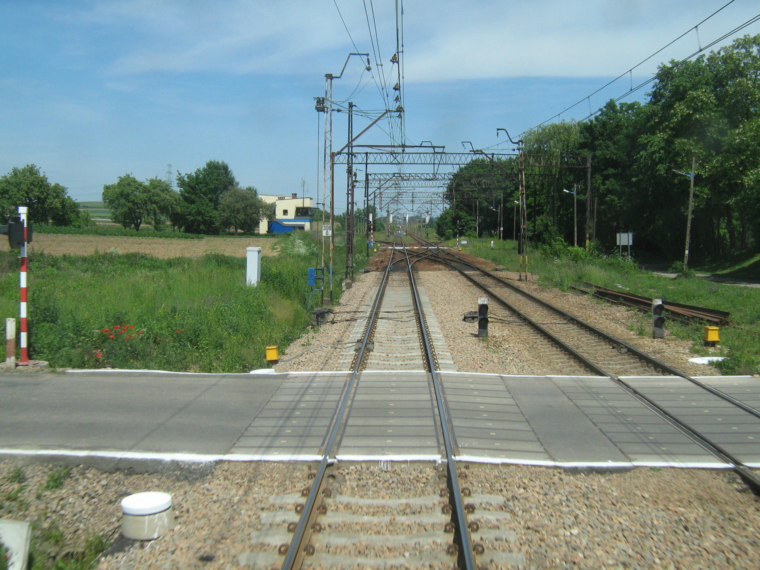
check this out:


The rails are converging but the sides of the crossing are parallel.

As for the left-to-right direction, it is unrealistic to expect to discern curvature from low altitudes on this axis because perspective is not a factor here, Flat-earthers have the expectation that side-to-side curvature can be calculated with the 8 inches per mile2 formula, but this formula is for calculating the drop (in feet or meters) due to curvature in the z-axis where the curve is curving vertically down and away from the viewer.
We cannot use the same formula to calculate the curve of the horizon (in radians or degrees) on the x-axis as it curves around the viewer.
 
The only way we'd see a 'left-to-right curve' would be if we were tens of thousands of miles away in space and gigantic enormous towers about 50-miles high were lined up across the 'top' of the globe over a span of a thousand miles or so - and even then we'd still be seeing 'the curve of the horizon'.

Perhaps that's technically true, to a point, but something I've learned recently is that some people differentiate between 'the curve of the earth' (aka, 'geodetic curve') and 'the curve of the horizon'.

This came up during a discussion about Neil deGrasse Tyson famously saying that Felix Baumgartner wouldn't have seen the earth's curvature from 128,000 feet, when obviously he would have seen a fairly pronounced 'curve', given that it can be seen from aeroplanes, and photographed from much lower elevations.

His statement was explained by saying he was referring to the geodetic curve. Though since the curve of the horizon exists because of the curve of the earth, I don't really see a reason to separate the two.

If anyone ever wants a thread killing, just ask me to whip up a spreadsheet.

Funny old thread, this one. It made perfect sense at the time, but reading it back I can barely make head nor tail of it: a good lesson in realising that things that seem clear may not seem clear to everyone (e.g., clear to past me, and bemusingly perplexing to present me).
 
Back
Top