Recreating the missing section of IB6830's ADS-B track

Mick West

Administrator
Staff member
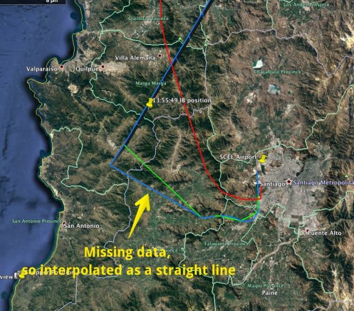
While IB6830 has been conclusivly identified as the "UFO" seen in the IR footage from the Chilean navy, the first few minutes of the video are a bit tricky to match up because the ADS-B data is missing:


6830 is a flight from Santigo to Chile which still runs today:
https://flightaware.com/live/flight/IBE6830

Departure seems consistent, on runway 17R, so 170°, basically just east of south. A little dogleg to get onto the bottom straight section, then a turn onto the long departure. I suspect this is to give it enough room to climb over the andes.
20170111-105301-knonc.jpg
20170111-105338-h211e.jpg


A typical departure is on 4-jan-2017, this exactly matches the initial climb and turn, although the second turn ends up a bit different.
20170111-105705-qw94b.jpg
20170111-110022-f6b0w.jpg

So it seems reasonable that we can take the 11-Nov-2014 track, and adjust it to be as close as possible as 4-Jan-2017 track, and that will give us something very close to the actual path flown. I'll probably have to do some manual method
 

Attachments

  • 20170111-105031-28bjg.jpg
    20170111-105031-28bjg.jpg
    443.3 KB · Views: 595
  • FlightAware_IBE6830_SCEL_LEMD_20170104.kml
    59.4 KB · Views: 912
Attached is a "Local Only" section of the Flightaware data - easier to deal with for time scale and elevation profiles.

The elavation profile looks like this:
20170111-115917-7wbe4.jpg

The big gap is the missing data. It goes 538 km/h, down to a flat 452 km/h, then jumps to 832 km/h

Altitude from 3194m to 5791m so over 11 steps that's +236.09

The gap starts at 13:48:39 and ends at 13:53:59 (+5m20s, or 320 seconds).

The actual video starts at 13:51:55, and we first see the plane targeted at 13:52:31, with the first image at 13:52:35 where it looks like the plane is already in the last turn. At the end of that IR segment at 13:53:07, the plane is still apparently banking.

When we see the plane again at 13:55:44 it is now level.


It is simplest to assume a constant climb rate and acceleration

Here's a preliminary curve, for ground track only. Puts the plane approx 37 miles from the chopper at closest point (which also seems to be the first contact)
20170111-122521-74gcg.jpg

20170111-122755-tger0.jpg
 

Attachments

  • IBE6830 FlightAware Local Only.kml
    4.1 KB · Views: 921
Last edited:
After reviewing the departure chart for the ESLAR 3 Departure, I think I had the plane turn too early, and it would have continued more towards the SNO VOR before the turn. Here I've adjusted it so the turn rate is similar to the more recent departure (in white)
20170112-173442-mufcc.jpg

Does not make a huge amount of difference, but brings it a little closer to the chopper.

 
Last edited:
And here are several more paths, they all do "straight towards SNO then proceed to TABON"
20170112-180306-ziveo.jpg

Our guy is slightly unusual in that he does not go direct to TABON, but has a more northerly heading. The track takes him on the other side of Mt Mercedario (22,000 feet).

20170112-180654-tu52j.jpg
 

Attachments

  • Other IB6830 Flight Aware Tracks.kmz
    41.8 KB · Views: 746
Our guy is slightly unusual in that he does not go direct to TABON, but has a more northerly heading.
Not unusual for November 2014. Here are the planefinder.net tracks for the previous four days:
Screen Shot 2017-01-13 at 09.23.02.png Screen Shot 2017-01-13 at 09.36.06.png Screen Shot 2017-01-13 at 09.31.52.png Screen Shot 2017-01-13 at 09.28.27.png

Perhaps, the departures have been tightened up lately.

PS All these flights went NW of of Mt Mercedario, like 2014-11-11.
 
Last edited:
Finally got a time-coded track with the estimated section. While this is only an estimate, I think it's fairly close to the actual track. And remember the estimated proportion is only relevant to the first 30 seconds of the video.

20170117-133118-europ.jpg
 

Attachments

  • IBE6830 FlightAware plus Reconstructed.kml
    6 KB · Views: 899
I'm revisiting this six years later, as I finall got around to putting it into Sitrec, and on Twitter it was pointed out that it does not line up exactly with this radar image. Specifically the angles.
Radar IB6830_009.png
2023-09-06_16-56-20.jpg
At 16:52:38, Sitrec gives a tail angle of about 25°, where the radar positions indicate more like 30.

Since I like Sitrec to be accurate, I'm going to delve into this a little more. But the issue seems to be that the speed at which I go around that curve is to quick at the start. The actual path is pretty close, although the radar indicates a tighter turn. 2023-09-06_17-05-02.jpg
 
2023-09-06_23-46-32.jpg
Taking the first 13 frames of the radar screenshots (in attached powerpoint), aligning them with the VORs. The white dots are the new radar position. The green line is my recreated path from 2017. I was so close!

But a bigger issue than points 8 and 9 being a bit off was the speed at which I traverse the path (too fast, then too slow). Now with timestamped positions, I should be able to add points 2-11 to the track to get a more accurate reconstruction
 

Attachments

  • TRACK DE VUELO ACOUGAR.pptx
    5.1 MB · Views: 45
Back
Top