Explained: Chilean Navy "UFO" video - Aerodynamic Contrails, Flight IB6830

Hello,

Excellent work. I am a licensed private pilot and can follow most of the issues raised here.

I have a couple of questions. If I have missed something in this long thread that would answer them, I apologize in advance.

1: The Navy personnnel first said that the UFO was observed coming in over the ocean. None of the videos show this. Did they turn on the FLIR after the object had flown over land?

2: Where did the pilot ask ATC to look for the object, and how did this contribute to any error when looking for its location on radar?

Thank you.
 
reflecting IR in a similar way to other clouds

I'm not sure about that, but it might depend on the particular sensor. Water/ice has very high emissivity (black) as far as my IR thermometer is concerned..
Anyhow, the rest looks good..
Capture.PNG
 
1: The Navy personnnel first said that the UFO was observed coming in over the ocean. None of the videos show this. Did they turn on the FLIR after the object had flown over land?

Can you quote what they actually said? It does not make sense because the land is on the right, and the plane is moving to the left.
20170111-095120-y7zmc.jpg
 
I'm not sure about that, but it might depend on the particular sensor. Water/ice has very high emissivity (black) as far as my IR thermometer is concerned..

Mine too. Perhaps it's not reflective, but it is like the clouds. Since the plane engines are so small in the frame it's adjusting the exposure for the whole picture. So sometimes the clouds and the contrail appear black because they measure warmer than the clear sky or background haze emissions.
20170111-095410-ahw9r.jpg
 
I'm not sure about that, but it might depend on the particular sensor. Water/ice has very high emissivity (black) as far as my IR thermometer is concerned..
As the satellite images suggest (the Terra image of the area was taken about hour and half before and the Aqua image was taken one hour after the video), flying far ahead of the chopper, IBE6830 was under clear skies. At the time the plane and the Sun were on the same (northern) side of the sky relative the camera. We know for visible sunlight that, due to Mie scattering, backlit contrails are brighter than front-lit ones. Would the Sun's IR radiation cause a similar effect on 'backlit' contrails, making hem look bright to a FLIR camera?
 
Mine too. Perhaps it's not reflective, but it is like the clouds. Since the plane engines are so small in the frame it's adjusting the exposure for the whole picture. So sometimes the clouds and the contrail appear black because they measure warmer than the clear sky or background haze emissions.
View attachment 23943

I don't have an IR camera but I have quite a reasonable IR thermometer. I spent quite a lot of time with it looking for heat losses from my house. It takes a bit of experience to get accurate results. For instance, You can't get a good reading off a widow as it stands. You need to tape a sheet of paper to it otherwise you get the effect of a reflection of the sky or your own body heat. Interestingly, you can get quite an accurate measure of cloud temperature, providing it is optically thick and physically thin.. The field of view makes it useless for contrails, but clear sky is usually of the scale, below -40 C. when vertical. We neeD to know more about the camera to understand what it shows. as 'IR' covers a wide range!
 
We neeD to know more about the camera to understand what it shows. as 'IR' covers a wide range!

While this is true, I think it's reasonable to simply note that it shows the same thing as the denser clouds, and contrails are dense clouds, so it's consistent with a contrail.

If it ever stops raining here I'll see what my IR camera shows.
 
A miraculous break in the clouds happened as I was typing the above.
20170111-103527-09l7q.jpg


Blue sky is off the scale cold <-4°F
20170111-103723-chf77.jpg


Clouds are "warm" at 36°F
20170111-103849-vn91s.jpg
 
Can you quote what they actually said? It does not make sense because the land is on the right, and the plane is moving to the left.
View attachment 23942

The original HuffPo article states:
"At 1:52 pm, while filming the terrain, the technician observed a strange object flying to the left over the ocean. Soon both men observed it with the naked eye. They noticed that the velocity and the altitude of the object appeared to be about the same as the helicopter, and estimated that the object was approximately 35 to 40 miles (55-65 km) away. It was traveling W/NW, according to the Captain."

Actually, this doesn't make sense, seeing as their GPS placed them at the coast (or near it) and the coast curves to the N/ NW. They stated that the object was traveling W/ NW, which would actually leave it out over the water, if it was there to begin with.
I took it to mean flying to the left which would take it out over the ocean (i.e. northwest) assuming that it was relatively nearby, where they thought it was.

If you look at the aircraft track, the early part is heading northwest, before the plane turns to the right and heads northeastwards, staying inland. The plane never flies over the sea but its initial heading would have taken it out to sea if it had continued without turning.

I'm thinking this is an error in reporting, as it is never anywhere over the water in the videos and the observed and video-recorded track would never have taken it over the ocean.
 
"At 1:52 pm, while filming the terrain, the technician observed a strange object flying to the left over the ocean."

I wish we could see the original Spanish. It's possible this is a clumsy translation where the clause "flying to the left over the ocean" was actually modifying the technician/helicopter. The subject of such clauses can be tricky to determine in translating, especially with machine-aided tools.
 
I'm thinking this is an error in reporting, as it is never anywhere over the water in the videos and the observed and video-recorded track would never have taken it over the ocean.
The wider view here shows the ocean on the left (the coastline curves around to the left/north in the distance).

IMG_9353.JPG

So if the object was heading left then it would be reasonable shorthand to say it was "heading left out to the ocean" or something similar, when they first saw it.

Remember at this point the crew are looking roughly northeast, so the plane on a NW heading is moving roughly straight across their path from right to left. The plane then turns left and heads more to the northeast, away from the helicopter, without ever crossing the coast (as you quite rightly say).
 
We have some very solid verifiable evidence in
  1. The helicopter video with timestamps and GPS coordinates.
  2. The IB6830 and LA330 ADS-B tracks with timestamps and GPS coordinates.
1 matches 2 in every way
  • IB6830 is in the right place at the right place
  • IB6830 is going in the right direction
  • IB6830 banks when the "UFO" banks,
  • IB6830 would create a visual thermal signature the same size as in the video.
  • IB6830 engine configuration matches the flares seen in the banking
  • The size of IB6830's thermal signature shrinks proportional to its distance, matching the video.
Lacking here is a line on the trails. I propose to add something like:

  • The apparent lengths of the trails are consistent with the distances IB6830 traveled in the corresponding time intervals and match the apparent lengths of the modelled contrails for a given high-altitude wind direction and speed.

Edit:
As an afterthought, it can be summarised shorter as:

  • Contrails derived from the IB6830's track would have the same apparent size as the video.
 
Last edited:
Ah, whoops.. At least they are not radians. Even so..
The degrees here are relative to the mount frame of the aircraft.
ie, you could be at 0 degrees the whole time, and could be looking into the ocean if the helicopter did a steep pitch forward, and looking into space if it did a steep pitch back.
Given that most helicopters dont fly dead level, you cant use this number to mean anything. The helicopter would be pitching different amounts during the flight.
 
Ah, whoops.. At least they are not radians. Even so..
The relevant part of IB6830 track fits within an area of 5° horizontally and 2° vertically when seen from the chopper's altitude. I've use the chopper position near the end and added a frame with the vertical FOV of 4° (HFOV 5.1°) to Google Earth:
VFOV 4°.jpg

If we take the helicopter's movement into account, deviations of the camera's elevation and heading from the initial values of the object tracking will be even smaller.
 
Last edited:
The degrees here are relative to the mount frame of the aircraft.
ie, you could be at 0 degrees the whole time, and could be looking into the ocean if the helicopter did a steep pitch forward, and looking into space if it did a steep pitch back.
Given that most helicopters dont fly dead level, you cant use this number to mean anything. The helicopter would be pitching different amounts during the flight.
Wot no gyro!
 
If the altitude of the plane was 5km. above the chopper and 50 km. away it should show up as ~5/50*60 = 6 degrees elevation and it shows nothing like that.
Yes, it is about right. For the added frame in my previous post, tilt is 93.00° (from nadir), so the elevation of the top edge is 5° (relative to the horizontal plane at the helicopter position). For the reference, the heading of the frame is 36.85°, which is greater that the helicopter and camera headings combined (17°+11°). The camera just was not set up properly. Its actual heading and elevation were determined here by matching wide angle frames with the ground features to Google Earth.
 
Last edited:
If the altitude of the plane was 5km. above the chopper and 50 km. away it should show up as ~5/50*60 = 6 degrees elevation and it shows nothing like that.

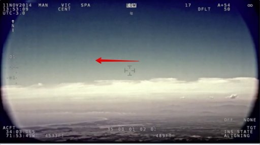
Consider this shot, the camera reads 0°
20170112-053455-d34dg.jpg


And yet if we geolocate it using the bay and the hills on the right as reference then the camera angle comes out as 1.86°

20170112-054805-rd2he.jpg


And that's where the plane is (I did not force this result, it's just from the bay/hill fitting)

There appears to be some image distortion here though that makes the fitting a bit tricky.
 
Although now I just noticed the chopper height was wrong there.
20170112-063508-a8dyu.jpg


A better fitting gives it 2.5°.

Geolocation tip. With just a bare scene the misty mountains on the right are not really visible. But with the paths in there extended to the ground it isolated them. I added another small path as a kind of extra fog curtain to align some of the nearer hills.

Also there's a -0.92° roll there
 
The heading in the camera image is about 8°,
20170112-064112-m12dy.jpg


but the actual heading by image matching is 31.75 degrees.

I wonder if this is the source of the "over the ocean" confusion - if they were only looking at the IR images and thinking the 8° was the actual heading?
 
I think it would REALLY help people understand what happened if the CEFAA actually released all the reports and all the conversations with the ATC etc.

For example: Did the Heli crew radio ATC and say " We have a craft NW of our position about 35 miles away at 4500ft. Can you see anything? " If so did the Santiago ATC say " Nope" or did they say" No, but at that heading there's one 65 miles away at 20,000ft?"

Basically NOBODY on this thread knows, and without knowing who said what we have no idea whether or not anybody was looking in the right place for a radar return or misinterptreted an answer or whether there really IS a mystery craft that is invisible to Radar but not IR.

Who exactly ARE the CEFAA anyway? They SEEM to be fairly official. Their website says they are officially a part of the DGAC, their website is a .gob.cl, their email is @DGAC.gob.cl and yet, as has been mentioned, their "partners" that they work with are very much people who lean towards the more fanciful explanations, (people like NARCAP for example)

It has already been shown earlier in the thread that they have been known to miss obvious things like Bugs close to the camera and the French analysts they used calculated the wrong camera and admitted they didn't even know what all the information on the screen meant but didn't think to ASK anyone. If I had been asked to investigate this I would certainly have phoned or emailed the manufacturers to ask what all these numbers meant.
 
Basically NOBODY on this thread knows, and without knowing who said what we have no idea whether or not anybody was looking in the right place for a radar return or misinterptreted an answer or whether there really IS a mystery craft that is invisible to Radar but not IR.

I think we have pretty conclusive evidence in the match with IB6830.

I mean maybe there was a craft that was invisible to radar that also happened to create an IR signature that matched what we would expect from IB6830 at the correct place and time. But that's getting a bit silly.
Engine Flares Matched to Path.jpg
 
I think we have pretty conclusive evidence in the match with IB6830.

I mean maybe there was a craft that was invisible to radar that also happened to create an IR signature that matched what we would expect from IB6830 at the correct place and time. But that's getting a bit silly.
View attachment 23988
I completely agree. You have found a plane that matches very well with what you would expect to see in the right patch of sky. that matches the behaviour of the object seen on the film. I would say IB6830 is pretty conclusive.
I WOULD like to know more about lack of radar returns and whether or not this ACTUALLY in the CEFAA report and if so where who was looking and when or whether this was made up by a reporter. I have seen claims elsewhere that this was restricted airspace but that appears to be a complete fabrication, they certainly offered nothing to back it up.
 
Back
Top