Bellingcat Analysis of Satellite Imagery Used In Russian Claims Against Ukraine

TEEJ

Senior Member.
Since all of the evidence presented by the Russian Defense Ministry press conference on July 21 has been debunked (here on metabunk, and on other sites) I'm not sure why you would still bring up their findings.

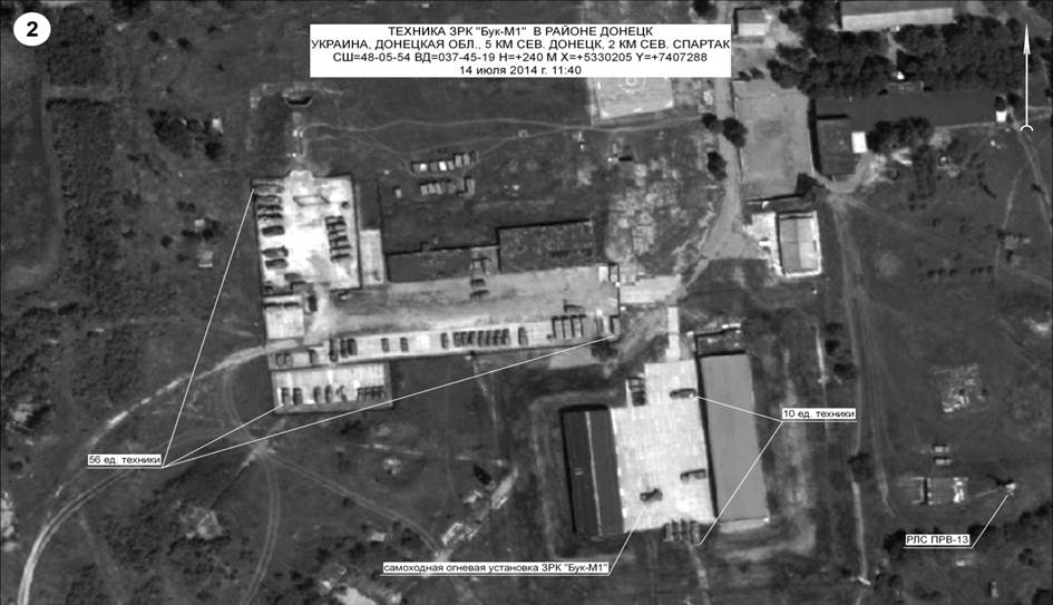
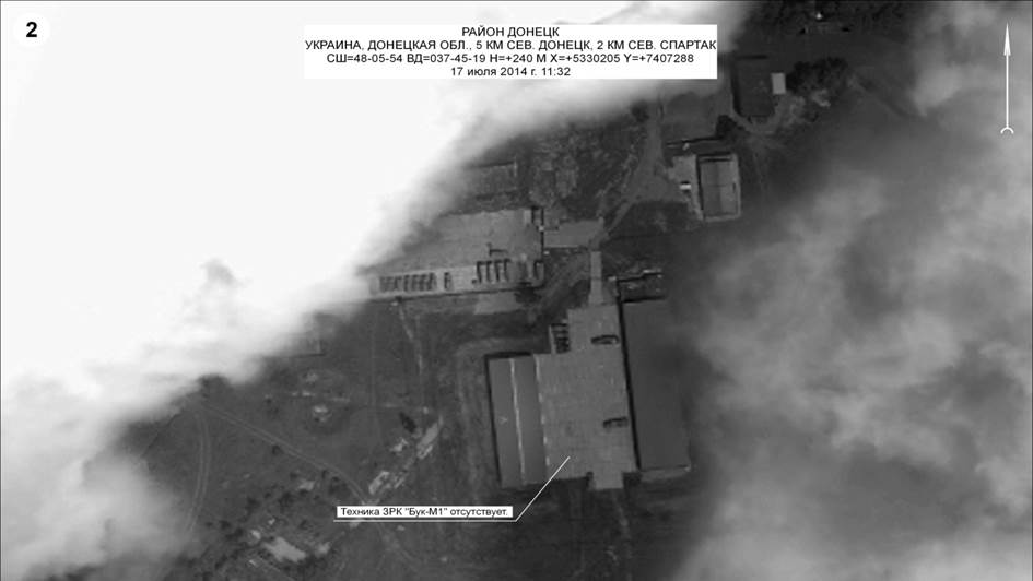
But just in case, here is that satellite image from the Russian Defense Ministry that shows an addition 2 or 3 buks (from RT) :

http://rt.com/files/news/2a/94/c0/00/snimok_ekrana_2014-07-21_v_18.47.57.png

Isn't there something peculiar about the shadows these BUKs cast ?


upload_2015-6-2_9-1-48.png

Following the publication of the report Forensic Analysis of Satellite Images Released by the Russian Ministry of Defence Bellingcat is now seeking to purchase satellite imagery of one location mentioned in the report.

Two images presented by the Russian Ministry of Defence shows a site on July 14th and July 17th, with the second image showing a Buk missile launcher based at the site absent on July 17th.

This same location is visible on Digital Globe imagery of the site on July 17th (Catalog ID 105041001104D000), and is visible in the preview imagery (seen below).The aim of this fundraiser is to purchase the image and make it publically available. Bellingcat will also publish a highly detailed comparision of that image to the images presented by the Russian Ministry of Defence, as well as additional information gathered about the site.

Digital Globe requires a minimum order of 25sqkm, and publishing rights are an additional cost, so we are aiming for a target of £800. Any additional money raised will go towards purchasing satellite images in the future as part of Bellingcat's ongoing investigations in Ukraine.

You can also donate directly with Paypal to brownmoses@gmail.com
Content from External Source
http://www.gofundme.com/bellingcatsat

Link to Russian Military Satellite image briefing.

http://www.mid.ru/brp_4.nsf/0/ECD62987D4816CA344257D1D00251C76
 
The Bellingcat report contains a few spurious elements which made me wonder how serious one should take it.

1. "The flight path was not altered in the way claimed by the Russian Ministry of Defence. Data from the Dutch Safety Board’s preliminary report and other sources"

As the preliminary official report used the same radar data as the Russians do, it certainly would be surprising! The Dutch report mentions at 13.00 hrs a request and permissions for a diversion of the track "20 NM to the left, due to weather". The report continues "at 13.19:53 hrs, radar data showed that the aircraft was 3.6 NM north of centreline of airway L980 having deviated left of track".

In kilometers, 3.6 NM is 6.67 km from airway centreline while the Russians write: "the maximum distance from the left border of the air-corridor was 14 kilometers". Usually in Europe airways are 10 nautical miles wide, that is 19 km. The Dutch report mentions a request for 20NM to the left while the Russians report a max of 7.5 NM on their data. There doesn't seem to be much exaggeration at all here but only after the Russian press release all the numbers and flight details were released.

The claim of Bellingcat that the flight path was not altered the way as described doesn't seem to materialize in numbers and data from the Dutch report. The picture might show exaggeration in the angles but the text is leading.

2. Bellingcat does not describe in advance what the procedure will be for examining the high-res picture. This leaves one open to the famous problem of bias in observation. One starts looking for discrepancies as they occur during research. Which is not a good approach as one should make it clear which elements will be examined, what would be expected and how to falsify. Then introduce new data!

Any proper null hypothesis is not present in the report. Which is this case would be other validated pictures from Russia's MOD which had gone through similar processes, capture, storage and release. There are many possible causes for JPG error rates, stitching for example or mishandling of pictures inside Photoshop without intentions.

Same with dating information on Google Earth material. It's not known to be a reliable dating source and not meant to be used like that. Many weird anomalies have been reported on that before, which is part and parcel for bulk data handling like that. It's also remarkable that the area under investigation was deforested just in the one month that it's under closer investigation. What are the odds?

On the whole Bellingcat provides a well intended but wholly amateurish approach to arm-chair sleuthing. There are no safe-guards in place to exclude bias, error and misinterpretation. So I propose a more thorough approach where all the evidence and witnesses will match up the same story. And it's still a long way to go!
 
Same with dating information on Google Earth material. It's not known to be a reliable dating source and not meant to be used like that.

According to Bellingcat, Google Earth gets their material from Digital Globe. In their catalogue (http://www.digitalglobefoundation.org/application-process) the exact date, time, position of the satellite, name of the satellite and coordinates of each satellite photo (also those from the past) are listed. Bellingcat counter-checked the data from all the Google-earth-pics they used as reference in their report with the Digital Globe data and said all Google-Earth data is correct.

Assuming that is true, Russia's MoD did show photos that were not shot at the time they claimed, therefore totally useless for the Ukrainian-Buk-Case. Very useful regarding russian credibility though.

I saw a report saying the Russians had "altered" those photos. Was it just the dating data they "altered"?
 
According to Bellingcat, Google Earth gets their material from Digital Globe. In their catalogue (http://www.digitalglobefoundation.org/application-process) the exact date, time, position of the satellite, name of the satellite and coordinates of each satellite photo (also those from the past) are listed. Bellingcat counter-checked the data from all the Google-earth-pics they used as reference in their report with the Digital Globe data and said all Google-Earth data is correct.

Do you have a link to that "counter-check"? For now I can only base myself on the published PDF "Forensic Analysis of Satellite Images", a weirdly undated document with not much of a process description either -- but that aside. In that PDF there's no reference to any Digital Globe data. Or even direct references to the Google Earth imagery of some of the more interesting material either but I guess I could find them myself if I tried. This verification is important as Google Earth historical and current date stamps are not always accurate on the day or even month. People have reported snow in July where it couldn't be! It would be better to have multiple sources in this case, which would mean more than one satellite provider. It's not known to me if the possible problems sit at Google or with Digital Globe. Looking at changes in less than one month is just a way less common usage for commercial imagery, so I'm even doubting it one can use the material this way reliably. Or at least one should know the error rate when selecting only a few images.
 
Herman Aven said "I guess I could find them myself if I tried. "

That is correct.
Master Yoda gave you the link.
Please let us know if you can find any evidence that GoogleEarth, using Digital Globe images, may have mis-dated the satellite images from airbase A-1428.

Until then, please give Bellingcat the benefit of the doubt that Digital Globe is reliable.
 
Herman Aven said "People have reported snow in July where it couldn't be!"

Can you give an example of that ?
 
Herman Aven said "I guess I could find them myself if I tried."

That is correct.
Master Yoda gave you the link.

Not at all. That link went to a general page for those wanting to apply for imagery grants. If Bellingcat wants to release evidence based on a verified source, it's up to them to publish it. But perhaps they did and for that reason I asked Yoda for a link to that material.

What I was talking about was a published research document of Bellingcat which does not contain any information on how they verified DigitalGlobe data, so I assume it might have been published later. To be more precise, my remark was actually about it not being clear to me with some images where the source was located in terms of coordinates or links to Google. But it's not a big deal, as I wrote, since I could find it out from another page elsewhere on the Internet but I was surprised it was not obvious from the sections I was reading.

Please let us know if you can find any evidence that GoogleEarth, using Digital Globe images, may have mis-dated the satellite images from airbase A-1428. Until then, please give Bellingcat the benefit of the doubt that Digital Globe is reliable.
No it just doesn't work that way. It's not me making claims about manipulation of military satellite imagery which was added to a PR statement as JPG's. First one should provide verified copies of DigitalGlobe images and make the case on the reliability of the timestamps. Which is what Google seems to recommend when they're asked. Then the original images of the MoD should become available but at best these will be supplied to the official MH-17 team. Can you see how this becomes a problem?

One reason I find this important is that I don't see that much differences for example between Bellingcat's Google Earth pictures of the 2nd and 21st of July (of the area in MoD's Picture 3 dated 14 July 2014 showing military unit A-1428). All I can see is that the first Google picture appears of slightly higher quality and shows therefore a few more details than the second.

So it would be crucial to know if the 2nd of July is really the 2nd and not the 21st or any other day in the month after the 14th, in which period some of the landscape appears heavily modified there, right before or after the alleged BUK operations. From what I understand two updates in three weeks of such area would be uncommon in the Google image database but perhaps some of the added traffic caused that additional copy to be added?

Check out DigitalGlobe's coverage map of Ukraine in 2014. Only a very few places were done that year. And was it satellite of aerial photography? They do both.

https://www.digitalglobe.com/downloads/coverage_maps/global_basemap/Coverage-Maps_Ukraine.pdf
 
Last edited:
Herman Aven said "People have reported snow in July where it couldn't be!"

Can you give an example of that ?

As for examples, there is no official statement of some kind so take the following as anecdotal. It doesn't seem like something to build an important case on unless the original imagery can be examined. Which is what you'll find generally as response although I lack at the moment any official statement from Google on that, either way.

"How Google Earth displays dates on their imagery"
http://www.gearthblog.com/blog/archives/2011/03/how_google_earth_displays_dates_on.html
"Verifying the Date on a Google Earth Images"
https://productforums.google.com/forum/#!topic/earth/gkuYG3Ysx44
"How accurate is the Google Earth Time Stamp"
https://productforums.google.com/forum/#!topic/maps/PbsRMe72T1E
""How reliable are the date stamps on Google Earth Images?""
https://productforums.google.com/forum/#!msg/earth/MfZcE0TSPeA/ZN60wsSaZu8J
 
@Herman Aven

I got my infos from a german forum (www.slinfo.de), where Bellingcat-Member Timmi Allen has posted the following:

"Google Earth bezieht seine Bilder von DIGITAL GLOBE. In deren Katalog kann man zu jedem Satellitenfoto (auch aus der Vergangeheit) das genau Aufnahmedatum, Uhrzeit, Position des Satelliten, Name des Satelliten und Koordinaten entnehmen. Die zur Referenz verwendeten Google Earth Bilder wurden im Katalog geprüft und entsprechen den angegebenen Daten."

This is basically what I translated into English in my yesterday's post here. The Link to Digital Globe came from there too. I suggest you contact Timmi Allen directly by yourself about their verification process re: Google Earth-pics data. On Bellingcat Website they refer to http://timmi-allen.com/. I guess that's the easiest way to contact him or ask him for details. Bellingcat's twitter account or their official contact email brownmoses@gmail.com might work as well.
 
Thanks. Of course I'll leave it to the Bellingcat people, who are making all the claims here, to present further verification of their evidence. It seems that the "gofundme" campaign which was linked to earlier went well so I hope to see the results posted somewhere soon! As the fundraiser states: "Bellingcat will also publish a highly detailed comparison of that image to the images presented by the Russian Ministry of Defence". Which is in my view a minimal requirement to back up somewhat credibly the conclusions already reached in their earlier research document. Best thing would be to compare the DigitalGlobe 25sqkm highres and available metadata regarding the dates to MoD highres images. In any case they should submit their findings as well to the Dutch Safety Board which is supposed to have already in its possession all the Russian radar tracking data and "several volumes of (digital) materials" from Russia’s Prosecutor General’s Office. And as well material from the U.S.
 
@Herman Aven

I got a direct answer from Timmi Allen/Bellingcat and should now be able to verify their Claim by myself (i hope :)). However, i don't have the time right now but will trying this evening and will inform here what i found out.

Here the answer from Timmi in German:

"ich gebe mal eine schnelle Erklärung, da ich im Moment wirklich von allen Seiten bombardiert werde.
Auf dem Link ist ein Link zum "Image Finder". Da jede Sitzung eine eigene ID bekommt, muss man selbst diesen Link anwählen.
Dann sieht man ein etwas veraltetes UI mit Weltkarte. Dort wählt man den Bereich mit Zoom aus.
Rechts daneben ist ein Fenster, in dem man mit "Modify Filter" die Einstellungen für den Zeitraum, den Satelliten usw. macht.
Diese Einstellungen dann übernehmen und im Hauptfenster auf suchen gehen. Es dauert eine Weile, dann öffnet sich ein Fenster mit einer Liste aller Bilder die zur Verfügung stehen.
Man hat eine Vorschau (Achtung wieder neues Fenster) mit den Daten zu der jeweiligen Aufnahme. z.B.

Catalog ID: 10300100338C0B00 Acq Date: Jun 19, 2014 Center Lat/Long: 48,007°/37,753°
Avg Off Nadir Angle: 7° Avg Target Azimuth: 339° Spacecraft: WV02 Band Info: Pan_MS1_MS2

für das Satellitenbild vom 19. Juni 2014. Es ist das Bild, welches auch in Google Earth verwendet wurde.
LG Timmi"

Translation (as good as it gets, as i'm not an english-native speaking person):

"i can only give a short Explanation, as i'm facing a barrage of questions from all sides momentarily. On the Digital Globe link there is a link to Image finder. As each session gets its own ID, the user has to choose this link by his own.
Then you can see a somewhat elderly UI with global map. There you choose the area with zoom. Right of it is a window, in which you can set the Time, Satellite etc. with "modify filter". Take These Settings and go on Search in the main window. It takes some time then a window opens with a list of all available Pictures. You get a preview (in a new window) with the data of the respective Picture, e.g.:

Catalog ID: 10300100338C0B00 Acq Date: Jun 19, 2014 Center Lat/Long: 48,007°/37,753°
Avg Off Nadir Angle: 7° Avg Target Azimuth: 339° Spacecraft: WV02 Band Info: Pan_MS1_MS2

for the satellite Picture from June 19th 2014. It's the same Picture which was used in Google earth.

Greetings
Timmi"

I will inform here on my findings later tonight.
 
The most important thing from the latest Bellingcat report about the satellite images from the Russian Defense Ministry is that we can ALL verify that the Russian Defense Ministry lied about the date the satellite pictures were taken that they presented in their press conference on the 21st of July.

For example, take this picture (of army base A-1428) the Russian Defense Ministry presented in their 21st of July press conference :

mh17_brief_04-900.jpg
http://stat.multimedia.mil.ru/images/military/military/photo/mh17_brief_04-900.jpg

As the text in the bullet suggests, the Russian Defense Ministry claimed was taken on July 14.

Note that in the left upper corner there is a patch of trees visible, with a corridor cutting through.

Now open up GoogleEarth, and enter these coordinates in the search field :
”48° 5’53.45″N, 37°45’14.80″E”
That leads you right to army base A-1428.
Then open GoogleEarth’s “history” tool, and step back to the July 2 image.

You will see this image of airbase A-1428 :

Screen Shot 2015-06-04 at 12.13.17 AM.png

(Note that I am taking this screenshot in the western US, and due to the time difference, this picture was taken July 2, 2014 in Ukraine)

Notice that the trees are MISSING, and thus these were removed BEFORE July 2 !

If you step back further in the GoogleEarth history tool, you find the patch of trees with corridor in the June 19 image, and even further back, in the May 30 image the corridor is not there yet.

So the image from the Russian Defense Ministry was taken between May 30 and July 2.

And thus, assuming the Russians knew when they took the picture, the Russian Defense Ministry simply LIED when they stated the picture was dated July 14.

----

Now it seems that there are some commenters (here and on many other internet sites debating the Bellingcat findings) who suggest that the Russian picture is correctly dated, and GoogleEarth has the date wrong.

So, let us check that.
After all, Bellingcat is open source journalism, and all evidence is publicly verifiable.

For starters, here is a wider screenshot from GoogleEarth of that July 2 image around airbase A-1428
Screen Shot 2015-06-03 at 11.44.05 PM.png

You can see the outlines of the July 2 swath that GoogleEarth used.

Now, GoogleEarth obtains its images from DigitalGlobe.
So, let us check this July 2 image against the image that DigitalGlobe provides from July 2, 2014.

To find that image, go to the main DigitalGlobe site (previously mentioned by Master Yoda) :
http://www.digitalglobefoundation.org/application-process

Then click on the "ImageFinder" link.
That will start a 'session' for you, and you can zoom in on airbase A-1428 (just north of Donetsk, Ukraine).
I selected a 'filter' to show all the previews from 5/28/14 - 7/19/14 with a nadir of less than 45deg and a cloud cover of 40% or less.

That gives me this catalog of images :
Screen Shot 2015-06-03 at 11.34.45 PM.png

I highlighted the July 2 image, and clicked "View", which gives us this (low resolution) preview :

showBrowseImage-1.png

All the cloud patterns match exactly, so this image directly from the DigitalGlobe catalog (id 1030010034CD4700, taken July 2, by the WoldView2 satellite) is clearly the image that GoogleEarth used for their July 2 history of this area.

You can do the same thing for the other images (May 30, June 19) that Bellingcat used in their analysis that shows the Russian Defense Ministry's satellite pictures of airbase A-1428 were clearly taken in June and decidedly NOT on July 14 and July 17.

So, GoogleEarth history dates are correct, as verified with the DigitalGlobe's image catalogue.

Thus Bellincat is right, and the Russian Defense Ministry lied about the dates on their own satellite pictures.

Simple as that.
 
Last edited:
You can do the same thing for the other images (May 30, June 19) that Bellingcat used in their analysis that shows the Russian Defense Ministry's satellite pictures of airbase A-1428 were clearly taken in June and decidedly NOT on July 14 and July 17.

So, GoogleEarth history dates are correct, as verified with the DigitalGlobe's image catalogue.

Thus Bellincat is right, and the Russian Defense Ministry lied about the dates on their own satellite pictures.

Although I agree that "July 14" picture is taken at earlier date, I am not so sure whether this was a deliberate disinformation, or a simple error. I went through the Google Earth history images of this area:
2014/04/28
20140428_buk.jpg
2014/05/30
20140530_buk.jpg
2o14/07/02
20140702_buk.jpg
2014/07/21
20140721_buk.jpg
2014/07/24
20140724_buk.jpg
Note that, with a few minor exceptions, the locations of the parked military vehicles did not change over months and match well the "July 14" locations:

The alleged "Buk" was parked in the same location at least between April 24 and September 3, 2014 and probably was there at July 14 as well. The question remains whether it was not there on July 17, as the "July 17" image suggests:

The most of the surrounding area is covered by clouds, hindering the date verification by comparison with the Google Earth images.
Note that in April 28 photo, the missile platform of the alleged "Buk" is at a clearly different angle relative the chassis, compared to the other photos, suggesting that it might have been used during this time for whatever purpose. It is not possible to say with confidence, however, whether it was moved between July 2 and July 21 or not:
2014/07/0220140702_zoom.jpg
2014/07/21
20140721_zoom.jpg
There are some minor differences between its zoomed images taken on these dates, but they can be attributed to slightly different viewing angles.

I think that an independent satellite image of this area on July 17 is still required to verify the Russian MoD claim about this alleged "Buk" not being there on the date.
 
Last edited:
Why on earth would it have been moved in the first place? In my opinion it would have been a very convenient "error" in light of what Russian military intelligence did with the Buk on the truck Luhansk video. All it takes is someone to order or mastermind the spin and imagery analysts have to make things move in order to either muddy the waters or create a manipulated version of events. They have a history of manipulation and fabrication when the pressure is on.

In the mad rush to get their version of the KAL007 story out Russian military intelligence ordered the pilot of the Su-15 Flagon (Major Osipovich) to fabricate an audio. Osipovich revealed during 1996 that to simulate radio static an electric shaver was used during the fabricated warning communications. Osipovich was also ordered to lie about firing incendiary rounds when his gun pods only had armour piercing rounds. In my opinion the Russian are masters at it. Do they even care if they are later found out or if internet sleuths rumble them? The mindset in my opinion is to get their version out as quickly as possible.


Sure, Russians, or more precisely, Soviets, had done it before and therefore their version of the event is not trustworthy. However, the same could be said about the Ukrainian version. Ukrainians graduated from the same Soviet school of disinformation and have a denial story of their own.

I am not taking sides in the current state of the Russia-Ukraine relationships, which have already split many of my friends and relatives. I am just trying to look objectively at the @Rob's evidence of Russian Defence Ministry LYING. Given that the alleged "Buk" was there a long time before and after July 17, it does not matter much that they apparently misdated "July 14" an earlier image. It could be a simple clerical error. For example, the image might have been taken on June 14, but inadvertently mislabeled as July 14, as there is just one letter difference in the Russian names of these months: 'июнь' and 'июль'.

I may reconsider my opinion after I am presented with a clear evidence of the "July 17" image of the Russian Defense Ministry's satellite pictures of airbase A-1428 had been taken decidedly NOT on July 17.
 
Given that the alleged "Buk" was there a long time before and after July 17, it does not matter much that they apparently misdated "July 14" an earlier image. It could be a simple clerical error. For example, the image might have been taken on June 14, but inadvertently mislabeled as July 14, as there is just one letter difference in the Russian names of these months: 'июнь' and 'июль'.

So they accidentally showed a wrong location for the BUK in Luhansk, , they accidentally showed a wrong flight path for MH17, they accidentally misinterpreted MH-17 debris as an SU-25 and they accidentally mislabeled their own satellite-photos. All this in the same presser which had the sole intention to prove Ukrainian's guilt. Right. Poor russian military, full of amateurs.
 
So they accidentally showed a wrong location for the BUK in Luhansk, , they accidentally showed a wrong flight path for MH17, they accidentally misinterpreted MH-17 debris as an SU-25 and they accidentally mislabeled their own satellite-photos. All this in the same presser which had the sole intention to prove Ukrainian's guilt. Right. Poor russian military, full of amateurs.
Whatever. It does not change the evidence of an alleged "Buk" being stationed at the airbase at the time. Whether it stayed there on the date of MH17 shooting or not remains to be seen.

[...] off-topic material removed
 
Last edited by a moderator:
As a remote sensing scientist, the convenient clouds that obscure the Russian July 17 image context concern me. As noted in post 270 there is no way to crosscheck the imagery against PD imagery. As Cheech and Chong once said, "looks like dog sh&#, smells like dog sh&#, tastes like dog sh&#, hmmm.... must be dog sh&#". Not very scientific, but sometimes in science you get a feeling that someone is cooking the books. As many discussions come down here, it devolves into Occam's Razor: a charlie foxtrot by an over rambunctious Cossack with a BUK; or a giant false flag conspiracy by the Ukrainian government and the EU - that which of has not been uncovered other than by RT.
 
..... I am just trying to look objectively at the @Rob's evidence of Russian Defence Ministry LYING. Given that the alleged "Buk" was there a long time before and after July 17, it does not matter much that they apparently misdated "July 14" an earlier image. It could be a simple clerical error. For example, the image might have been taken on June 14, but inadvertently mislabeled as July 14, as there is just one letter difference in the Russian names of these months: 'июнь' and 'июль'.

If it were simply a "clerical error", like typing 'июль' while they meant 'июнь', then the Russian Defense Ministry had more than 10 months to correct it.

They did not, not even now that Bellingcat pointed it out so clearly (in fact Bellingcat is disingenuously being attacked by Russian media for "photo scoop" right now).

So we can safely conclude that the Russian Defense Ministry DELIBERATELY misdated the A-1428 image as "July 14".

After all, we know for a FACT that the "July 14" picture from the Russian Defense Ministry was taken between May 30 and July 2 (see Bellingcat report or my post #268 above).

I may reconsider my opinion after I am presented with a clear evidence of the "July 17" image of the Russian Defense Ministry's satellite pictures of airbase A-1428 had been taken decidedly NOT on July 17.

You start to sound like the thousands of Russia "apologists" that have been flooding internet comment sections of Ukraine conflict over the past year (and especially since MH17). The ones that keep on asking other people to provide more evidence, and when presented with indisputable evidence, simply move on to asking for more evidence on the next issue, determined to latch on to any statement that can be mis-interpreted, so that the path of truth can be avoided.

I know that you are better than that, so I'm appealing to your sense of reason on this issue.

Regarding the picture that the Russian Defense Ministry labeled as "July 17", the first thing to note is that the area that is not covered by clouds is VERY similar to the "July 14" image, suggesting the two images were taken around the same time (within days or weeks).

Meanwhile SPECIFIC details in BOTH images differ from the GoogleEarth/DigitalGlobe images from July.

Specifically for this location (A-1428) and both satellite images (labeled "July 14" and "July 17" pictures) from the Russian Defense Ministry, the Bellingcat report
https://www.bellingcat.com/wp-content/uploads/2015/05/Forensic_analysis_of_satellite_images_EN.pdf
pointed out the area in the center of both pictures, where the grass is destroyed and the soil is exposed (most likely since some vehicles stirred up the soil) at the end of May :

Screen Shot 2015-06-05 at 12.27.07 AM.png

The damage to the grass in this area from both pictures from the Russian Defense Ministry matches closely with the May 30 GoogleEarth/DigitalGlobe image. And specifically is no longer present in the June 19 and July 2 images.

You posted all the full size images above in your post #270 above, so these observations are easy to verify.

Thus, this comparison suggests that both the "July 14" as well as the "July 17" images from the Russian Defense Ministry were taken BEFORE June 19, and most certainly before July 2.
 
Last edited:
@Herman Aven

I got a direct answer from Timmi Allen/Bellingcat and should now be able to verify their Claim by myself (i hope :)). However, i don't have the time right now but will trying this evening and will inform here what i found out.


Catalog ID: 10300100338C0B00 Acq Date: Jun 19, 2014 Center Lat/Long: 48,007°/37,753°
Avg Off Nadir Angle: 7° Avg Target Azimuth: 339° Spacecraft: WV02 Band Info: Pan_MS1_MS2


for the satellite Picture from June 19th 2014. It's the same Picture which was used in Google earth.

I'm confused, was the fundraiser not for, I quote Bellingcat "Digital Globe imagery of the site on July 17th (Catalog ID 105041001104D000), and is visible in the preview imagery"? Maybe I missed something. It seems it would be better to compare it with a date closer by the claim? The June picture doesn't seem very useful in terms of quality from what I've seen, contrast and detail levels are way off.
 
All the cloud patterns match exactly, so this image directly from the DigitalGlobe catalog (id 1030010034CD4700, taken July 2, by the WoldView2 satellite) is clearly the image that GoogleEarth used for their July 2 history of this area.

Uhmm, no, different zoom levels can use different sources and batches of imagery, even different sources than WorldView-3, WorldView-2, WorldView-1, GeoEye-1 and Quickbird data. It's not clear to me how you get from the Pan-MS1-MS2 grab to the Google Earth maximum zoom as used in the report. It seems to me nothing is verified yet.

You can do the same thing for the other images (May 30, June 19) that Bellingcat used in their analysis that shows the Russian Defense Ministry's satellite pictures of airbase A-1428 were clearly taken in June and decidedly NOT on July 14 and July 17.

Yes, so the fact that DigitalGlobe search gives you only June 7, June 19, July 2, and July 24 highlights the problem with for example Bellingcat's supplied photo from Google Earth, dated July 21st..... from their report page 13

Figure E: Area B – Satellite photo from Google Earth on 21 July 2014

A date not in the catalog then?
 
There are more problems with the Bellingcat research surfacing.

'Bellingcat Report Doesn't Prove Anything': Expert Criticizes Allegations of Russian MH17 Manipulation - Spiegel

This is the view of Forensics expert Jens Kriese, who developed the stock photo archive IRISPIX and is a professional image analyst and owns an office for digital imaging forensics in Hamburg. His critique involves the sections on Error Level Analysis.

Another serious critique on ELA comes from Dr. Neal Krawetz, the maker of the Analysis tool used in the Bellingcat report (http://fotoforensics.com) on Twitter:

Good example: Report pg 12 (English). Annotation clearly added. Rest has undergone multiple resaves via saving annotation

Yeah... chalk this up as a "how to not do image analysis
.​
 
Last edited:
The Google Earth version of Digital Globe imagery is slightly degraded from the original DG imagery. Thus the desire to purchase the original imagery with radiometric calibration capability and the ability to exploit the full DN range for enhancements.
 
Jens Kriese studied biology at Justus Liebig University in Giessen, Germany, and worked as a scientific researcher and in the field of e-learning. He developed the stock photo archive IRISPIX and is a professional image analyst. He owns an office for digital imaging forensics in Hamburg.
Content from External Source
In my world you generally have a Ph.D. in image sciences (EE, mathematics, or Remote Sensing) to be an expert in imagery. I am not sure that "studying" biology, "scientifically researching" something, and e-learning makes you a certified expert in image analysis. Aside from that, his comments are just a blog interview and not subject to journalistic investigation. You could interview me and I might give just the opposite answers. The reality, contrary to what Mr. Kriese states, is that the human eye-brain mechanism is orders of magnitude better than any algorithm. We use image analytics as a starting point and then we we use our built in fuzzy analog computer to interpret the subtleties.
 
In my world you generally have a Ph.D. in image sciences (EE, mathematics, or Remote Sensing) to be an expert in imagery. I am not sure that "studying" biology, "scientifically researching" something, and e-learning makes you a certified expert in image analysis. Aside from that, his comments are just a blog interview and not subject to journalistic investigation. You could interview me and I might give just the opposite answers. The reality, contrary to what Mr. Kriese states, is that the human eye-brain mechanism is orders of magnitude better than any algorithm. We use image analytics as a starting point and then we we use our built in fuzzy analog computer to interpret the subtleties.

Fair enough but we're discussing the analysis of Bellingcat, which is basically citizen journalism and bloggery. At least the critique came from a professional in digital imaging forensics (http://digital-image-forensic.de) with some credit and name to risk. But what matters of course is the logic and verifiability of the various claims, whoever made them. Kriese comments more on overall process and provides some in his eyes obvious explanations for a couple of anomalies.

The problem with providing any thorough counter-analysis by any established "expert" is often more about time, money and motivation. It's not uncommon for pseudo-scientific quacks to demand the same level of effort in disproving the claims as they poured into their research. Or even dare to point to any lack of counter-effort as some negative proof. Not saying Bellingcat is guilty of this but just warning for the sliding slope into that particular swamp.

So far we should not forget that Bellingcat analyses illustrative material attached as heavily illustrated JPG files to a press release of the Russian MoD. From a professional point of view that would be useless exercise (one big non sequitur) if it were not for all the exaggerated media attention. The best conclusion Bellingcat could ever offer from a more formal perspective is the casting of some shadows and raising some doubts over that press release. However what matters is what would be submitted to the body which has to reach a formal verdict based on all the evidence.
 
The topic here is these satellite images. Please try to stay on topic. New topics in new threads (assuming PG)
 
The Google Earth version of Digital Globe imagery is slightly degraded from the original DG imagery. Thus the desire to purchase the original imagery with radiometric calibration capability and the ability to exploit the full DN range for enhancements.
i dont understand what i am supposed to be looking at. Should i be ignoring Rob because his comments arent what im supposed to be looking at?
Because i see lines in all 4 of these pictures.
a.PNG

i dont see any missing trees.

and July 23rd the lines are basically "gone" too... they are there, just the photo looks more like the May photo.
e.jpg

and is it weird (or off topic) that Google Earth hadn't photoed this area since 3/16/13 and hasnt since 9/20/14? and yet it was photographed quite regularly between March2014 and Sept 2014. :confused:
 
You start to sound like the thousands of Russia "apologists" that have been flooding internet comment sections of Ukraine conflict over the past year (and especially since MH17). The ones that keep on asking other people to provide more evidence, and when presented with indisputable evidence, simply move on to asking for more evidence on the next issue, determined to latch on to any statement that can be mis-interpreted, so that the path of truth can be avoided.
Well, it was not unexpected. There is an apparent lack of Russian "apologists" in this forum, so sooner or later I would have been labeled as one. This was a reason for my staying away from forensic analysis of the Ukraine events related images, including MH17. It was your suggestion to look at the Google Earth historical images (#13) that dragged me into this discussion. I did not read the Bellingcat report before, so I assumed that it was your own analysis of the "July 14" image. I felt that its conclusion fell short of the Metabunk standards, so I made a point about it. Now I have read their analysis of "July 17" image and agree that Russian Defence Ministry deliberately put wrong dates on both images.
It comes as no surprise to me. I would expect them to provide a disinformation by default and can only wish they would have done it more professionally:cool:.

However, there is a thing that I learnt growing up in the Soviet Union - pay attention to the information "between the lines" of the official reports. The dates can be false, but the satellite images are probably genuine and they suggest that that alleged "Buk" was not at its usual parking spot at some date together with three more vehicles from the same parking lot (red rectangular):
Screen Shot 2015-06-06 at 22.59.23.png

The Bellingcat analysis puts this date in June 2014, one month before the MH17 fatal shooting. This dating may seem to make these military movements irrelevant to the incident itself, but in a broader context they may have significant implications. At the least, the Russian satellite images cast doubts on the Ukrainian claims that their military never deployed antiaircraft weapons in the region of conflict and even put their "Buks" there out of use to prevent them falling into the rebels' hands. Which in turn presses the Russian's point: why Ukraine did not close the airspace for civil airliners well before the incident, if they knowingly deployed or intended to deploy such weapons.

The Google Earth historical images provide some indirect evidence that the alleged "Buk" may have been moved out and then returned back between May 30 and July 2, 2014. In the above image, there is a track marked with green arrow that begins near the Buk's parking spot. It looks fresher in that image than in May 30 GE / Digital Globe image. Also, in July 2 image its extends in a new direction, compared to May 30 image:

 
Last edited:
Sure, Russians, or more precisely, Soviets, had done it before and therefore their version of the event is not trustworthy. However, the same could be said about the Ukrainian version. Ukrainians graduated from the same Soviet school of disinformation and have a denial story of their own.

I am not taking sides in the current state of the Russia-Ukraine relationships, which have already split many of my friends and relatives.

We have to take into account that this is big time politics we're dealing here, so feelings come into play and objectivity tends to be lost.

I can already notice great effort in pointing out misinformations on the Russian side, but no effort at all to analyse the Ukranian side.

All governments lie, specially when there's great stakes at play.. it's not a Russian or Soviet thing, we're all grown-ups here, I think it would be helpful to analyse mis/disinformations from the Western side, related to this conflit.

I think I'm right to assume most of the people publishing here are westerners, so it would add to the credibility of the site to focus also on our lies..

Anyway, this is the feeling I get browsing through the site..
 
I can already notice great effort in pointing out misinformations on the Russian side, but no effort at all to analyse the Ukranian side.

This isn't a debate trying to establish which government lies the the most. Metabunk is about investigating individual claims of evidence, not playing one off against another.

If there's some specific Ukrainian misinformation that needs debunking, then please feel free to start a new thread about it. But see:
https://www.metabunk.org/threads/posting-guidelines.2064/

I do understand that, man, I'm sure you only care about the individual claims, but whether you want it or not, the site tends to create an image by itself, and I expressed my feeling of it, as an outsider, on this issue..

I'm not that good, at least at creating a case from scratch in a way that wouldn't be noticeable from the rest of the site, in terms of quality, but I'll leave the door open, thanks..
 
I do understand that, man, I'm sure you only care about the individual claims, but whether you want it or not, the site tends to create an image by itself, and I expressed my feeling of it, as an outsider, on this issue..

I care about the bigger issues. But the way I try to help is by focusing on individual claims of evidence in depth so they can either be verified, or debunked in a focussed and comprehensive manner that removes them from the equation, and helps people to focus on real things.
 
I care about the bigger issues. But the way I try to help is by focusing on individual claims of evidence in depth so they can either be verified, or debunked in a focussed and comprehensive manner that removes them from the equation, and helps people to focus on real things.

And you're doing a good job at it (you really seem to have a computer-science-mind, this site has a clear stackoverflow feel)

Just to put my previous point into perspective: on searching for Russia on the site, there are two main threads that show up on the first page, one is this one "Analysis of Satellite Imagery Used InRussian Claims Against Ukraine", the other is "Claim: Robert Parry: Australian 60 Minutes fudged evidence to pin blame on Russia", about debunking the debunking of Australia 60 minutes trying to atribute blame on Russia..

So, like in debunking chemtrails, the community, as a whole, demonstrates an interest on debunking them, on the Russia-West issue, it seems that the community is also taking a stand. And no, I know it's not a conspiracy..
 
So, like in debunking chemtrails, the community, as a whole, demonstrates an interest on debunking them, on the Russia-West issue, it seems that the community is also taking a stand. And no, I know it's not a conspiracy
This discussion whould be in chit chat or general discussion. You are distracting from the topic.

The community has an interest in debunking period.

If you have a claim of evidence that Ukraine lied or that "Contrail people" lied/spread bunk using evidence, feel free to present it. Your debunks dont have to be stellar or even present, the members will help with the debunks.
 
It was your suggestion to look at the Google Earth historical images (#13) that dragged me into this discussion. I did not read the Bellingcat report before, so I assumed that it was your own analysis of the "July 14" image. I felt that its conclusion fell short of the Metabunk standards, so I made a point about it. Now I have read their analysis of "July 17" image and agree that Russian Defence Ministry deliberately put wrong dates on both images.

Thank you, Trailspotter, for checking the publicly available evidence on the "July 14" and "July 17" image analysis done by Bellingcat. It takes guts to face the facts and accept the conclusions, before moving on to the next subject, and that is why I gave you a thumbs up on that post.
 
I did not read the Bellingcat report before, so I assumed that it was your own analysis of the "July 14" image. I felt that its conclusion fell short of the Metabunk standards, so I made a point about it. Now I have read their analysis of "July 17" image and agree that Russian Defence Ministry deliberately put wrong dates on both images
right? it's not like anyone made it easy to find the bellingcat link. (thanks Herman! got it from one of your links). I see the issues now too.

But wouldnt it have been alot easier and less confusing to just show the truck thing (BUK thing?) never moved? well if we want to believe the google dates. :confused: ( i know i didnt do a great job with my lines..july 23 it looks like it moved but the angle is slightly different. Is a bit strange though the shadows of the trucks are EXACTLY the same on July1 and July 20.)

not moved.PNG
 
Back
Top