Full-Disk HD Images of the Earth from Satellites

Mick West

Administrator
Staff member
HD Full Disk Satellite Images Metabunk.jpg

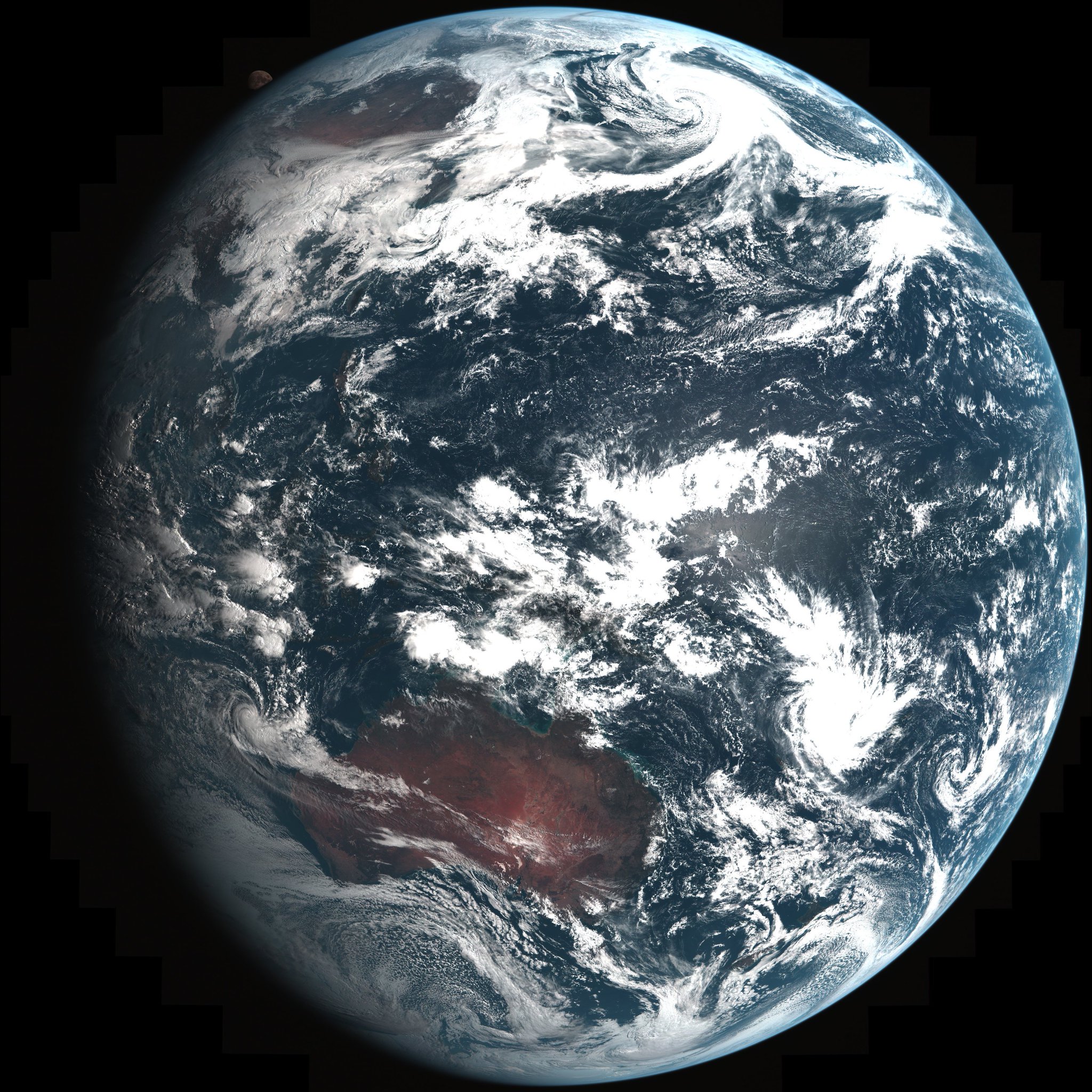
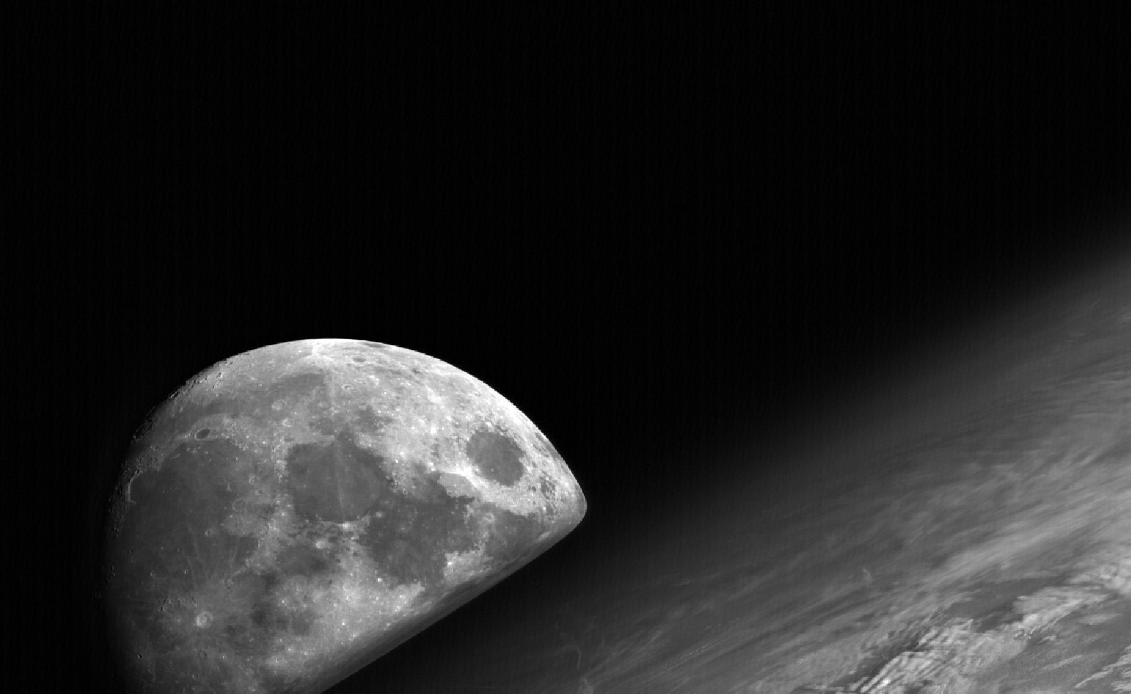
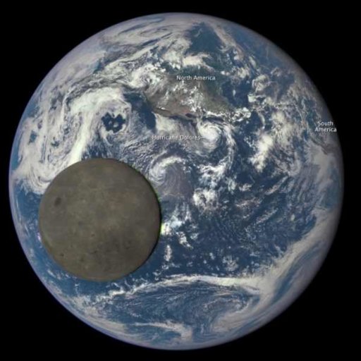
There are several satellites that take photos of the full disk of the earth on a regular basis, but the most impressive are the three above. The first two (Himawari-8 and GOES-16) are geostationary satellites taking photos from 22,236 miles above the Earth's equator. The third, DSCOVR is located in an orbit between the Earth and the Sun, about one million miles away. All three take several photos a day.

Quick Links To Full Disk Satellite Feeds


Himawari-8 is a Japanese weather satellite, and so is in orbit over the Equator with a good view of Japan. It is remarkably high resolution, producing images 11,000 pixels square (121 Megapixels), and in color. It can go up to 22,000 pixels (484 megapixels) in B&W (using just the red wavelength of light)
http://www.data.jma.go.jp/mscweb/en/himawari89/space_segment/spsg_ahi.html
ahi_obs.png

The following link goes to a smaller version of the full-disk image (5500x5500) but still gives you an idea of how detailed it is. Remember it does this every ten minutes:
https://www.metabunk.org/sk/full_disk_ahi_true_color_20170509030000.jpg

If you zoom in you can see detailed cloud patterns like these over Japan. The resolution is high enough that you can match up the clouds with the ground truth observations of the same clouds viewed from the ground.
20170509-103736-sbki1.jpg

You can find these images, and animations, at:
http://rammb.cira.colostate.edu/ramsdis/online/himawari-8.asp

20170509-103842-lpa5w.jpg


Remember this is just a small part of the 121 megapixel image of the globe that Himawari-8 takes every 10 minutes.

Himawari-9 is the identical sister satellite operating as a backup and replacement for Himawari-8

GOES-16 Is basically NASA's version of Himawari-8. Like the Himawari series, the GOES series have all been weather satellites. Their primary mission is helping forecast the weather, so up until now they have just given black and white images (one visible wavelength, and several infrared wavelengths). GOES satellites have actually been taking full disk images for many years, but GOES-16 is by far the best, with a higher resolution camera, and color. Here's a comparison of GOES-16 and GOES-13 taken at about the same time. Notice the position is different, GOES-16 being further west than GOES-13
20170509-112619-3gcxj.jpg


GOES-16 is not yet fully operational, but will be soon and will send back 100 Megapixel images. Here's a link to an early example full size image.
https://www.metabunk.org/sk/abi_full_disk_jan_15_2017_high_res.jpg
From: https://www.nesdis.noaa.gov/content/goes-16-color-composite-images
20170509-120943-zoh5c.jpg

Again we can zoom in to see sufficient detail to compare with "ground truth" observations from below. Here we can see individual airplane contrails off the coast of California.
20170509-110554-s8100.jpg


Ten years ago I used MODIS imagery to match ground truth observation to the satellite's viewpoint:
http://contrailscience.com/contrails-above-and-below/
20170509-110915-ofrh4.jpg

The ancestor of the GOES satellites is ATS-1, the first satellite to give full disk images of the Earth back in December 1966.
https://www.nesdis.noaa.gov/content/50th-anniversary-ats-1
20170509-105910-2h3jk.jpg


DSCOVR lacks the high resolution of the other two, but more than makes up for it with it's unique position in space. It's orbiting a point between the Earth and the Sun called a Lagrange point, where the combined gravitational and centrifugal forces balance out to keep it in place between the Earth and the Sun
20170509-111223-o4xqf.jpg


That means it's always in daylight, overhead at noon everywhere in the world, and so you see the earth spinning below you, fully illuminated.

Source: https://www.youtube.com/watch?v=-7j-0orCtYs


Occasionally it will see the moon pass in front of the earth.

Source: https://youtu.be/URFrfNTkFSM

(the colored fringes are due to red, green and blue images being taken separately and combined, the moon is moving relatively fast, so they overlap a bit)

GOES-16 and Himawari-8 are the best single image full-disk photos we can get at the moment, but there are some others worth looking at.

Meteosat-10 is the European version, one of several European weather satellites, it has half the resolution of GOES-16 and Himawari-8, but still produces great full-disk images of the globe.
http://oiswww.eumetsat.org/IPPS/html/MSGIODC/RGB/NATURALCOLOR/FULLRESOLUTION/
Here's one from this morning:
https://www.metabunk.org/sk/Kh9Xnwct4TH5h.jpg
20170509-113957-r1qee.jpg

Detail:
20170509-114052-4p35o.jpg


Elektro-L is Russia's version, similar specification to Himawari-8, with a 121 Megapixel camera.
http://www.russianspaceweb.com/elektro.html
ElectroL_Auto6.jpeg


Source: https://www.youtube.com/watch?v=y4er-S_lNRs

Full Disk images:
http://planet.iitp.ru/english/elektro/elektro_data_eng.htm


Feng yun 4A is China's version. But does not seem to be full operational yet.
https://spaceflightnow.com/2016/12/...ationary-weather-satellite-launched-by-china/
However older Feng Yun 2 satellites have been taking full-disk images for nearly 20 years.
20170509-115642-k8ogw.jpg


There are also similar satellites from India (INSAT) and Korea (COMS).

For a detailed overview of the history all such satellites, see:
https://goes.gsfc.nasa.gov/text/geonews.html

A flterable list of satellites:
https://www.wmo-sat.info/oscar/satellites
 
Last edited:
is that the actual atmosphere we are seeing around the edges?

You can see the atmospheric haze increase as you get closer to the edge.
20170509-124943-lhqqc.jpg

I'm not entirely sure if there's some masking there though.
 
Last edited:
I just measured the apparent sizes of the moon and the Earth in those images to check whether they are as they should be.

It's a little tricky to get an accurate size for the small moon image, as it is not fully visible, but I make it about 49 pixels in diameter. The Earth diameter, pole to pole, is about 2020 pixels.

So the ratio is 49/202 = 0.0243.

Himawari-8 is in geostationary orbit, 42,164km from the centre of the Earth.

The average distance from the centre of the Earth to the centre of the moon is 385,000km, which puts the distance from the satellite to the centre of the moon at about 427,164km. (The actual distance between the Earth and the moon varies by about 12% during its orbit.)

The polar diameter of the Earth is 12,714km. The diameter of the moon is 3,474km.

So, dividing the size of the Earth by its distance from the satellite, we get 12,714/42,164 = 0.302.

Dividng the size of the moon by its distance from the satellite, we get 0.0081.

That is a ratio of 0.0081/0.302, or 0.0268.

That is within 10% of the measured ratio from the image, which is pretty close (especially as the distance to the moon varies by more than this amont during the orbit.
 
Paraphrased reactions I've already gotten or seen in YT comments:

-Cracks me up. You actually think this is real?
-Where are the stars?
-Clouds don't move.
-You see the hot spot (which means the specular reflection of the sun) on the ocean, but you never see it on the land. So, they just forgot to put it in? LOL
-The colors are wrong. Australia is bright red?
-Where are all those satellites that are supposed to be up there? Not one in sight. So, we can supposedly see the ISS from the ground but we can't see it here?
-We asked NASA to show us a continuous shot of the Earth from space. What we got is once every ten minutes? Where is the continuous video?
-NASA is using ground based information about the weather and making these CGI fakes. Of course it matches up with local weather.
-Where is the Aurora Borealis?

Just look at the first three comments on that WP article linked to above.

External Quote:

Zeke Veitenheimer
4/14/2017 3:53 PM PDT
Youtube NASA LIES or HOAX. The truth is coming out and they cant stop it.


Johnny Conger
4/14/2017 2:11 AM PDT
Just more cartoons of earth from space...why fake it if they are not hiding something...


Richard Gobbels Jr.
4/12/2017 2:26 PM PDT
This is great, their CGI is getting much better... NOT! I can't believe people fall for this fake crap!!
 
Last edited:
The images from DSCOVR showing the Earth and the Moon are also often cited by conspiracy theorists as looking "the wrong size", usually by comparison of photos of the Earth from lunar orbit, where of course it looks much smaller than the moon.

Using the same simple maths as I used above for the Himawari-8 image on this DSCOVR image:

IMG_2137.JPG

I get:

Measured diameter ratio moon/earth = 206 pixels / 562 pixels = 0.367.

Calculated ratio, based on distance to Earth of 1,500,000km and distance to moon of 1,115,000km, = 0.356.

Again this is clearly consistent, within 3% of the expected figure, which is negligible given the variation in the distance to the moon, and the approximation of the distance to the L1 point where DSCOVR is parked. (I haven't been able to find a more precise figure than "1.5 million km from Earth").
 
Two questions:

Why does the moon looks flat from the dscovr satellite?

Why the feng yun 4A photos are in black and white?
 
Two questions:

Why does the moon looks flat from the dscovr satellite?
It doesn't. If you look at a full-resolution image you can clearly see that it is a three-dimensional ball, with shading and perspective effects on the craters that you would expect to see. It looks smoother than the moon we are used to seeing on Earth, because this is the far side, which we never get to see from Earth.

upload_2017-5-10_13-56-13.png


(You can also see the coloured fringing effects, caused by the relatively rapid motion of the moon, which means it has moved a little between each camera exposure: the colour image is created by taking exposures at different colour wavelengths, one after the other.)

Why the feng yun 4A photos are in black and white?
They're not. The older Feng Yun 2 image posted above is in black and white, but FY 4A will provide colour images as it has far more waveband channels:

External Quote:
Satellites of the new generation possess more observation channels and are capable of providing more rapid updates which are of higher resolution. For instance, the FY-4A satellite is equipped with 14 observational channels. This is 2.8 times of the 5 observational channels of the previous generation.
http://www.weather.gov.hk/m/article_e.htm?title=ele_00488
 
It doesn't. If you look at a full-resolution image you can clearly see that it is a three-dimensional ball, with shading and perspective effects on the craters that you would expect to see. It looks smoother than the moon we are used to seeing on Earth, because this is the far side, which we never get to see from Earth.

View attachment 26774

(You can also see the coloured fringing effects, caused by the relatively rapid motion of the moon, which means it has moved a little between each camera exposure: the colour image is created by taking exposures at different colour wavelengths, one after the other.)
Also, if you compare images of the moon from the start of the DSCOVR transit from images from the end of the transit, you can see the fact that the moon rotated slightly relative to DSCOVR in that time frame.
http://h.dropcanvas.com/gwxga/moonmoved.gif
This perfectly agrees with the amount of rotation expected given DSCOVR's position in space, as seen in this comparison simulation from Celestia:
http://h.dropcanvas.com/u7r7h/moonrotationgif.gif
 
Mick,
How do I find the current image? Every one I find is from Jan.
GOES-16 is not fully operational yet, so the available images are limited to test data, and it's not continually transmitted.

Like many weather satellites you could point a dish at it yourself, and download the data. Some guy in Brazil downloaded some test images in March.
http://www.teske.net.br/lucas/2017/04/goes-16-test-week-results/
2kTup6zl.jpg


You can get regular Himawari-8 images here: http://rammb.cira.colostate.edu/ramsdis/online/himawari-8.asp
 
Measured diameter ratio moon/earth = 206 pixels / 562 pixels = 0.367.

Calculated ratio, based on distance to Earth of 1,500,000km and distance to moon of 1,115,000km, = 0.356.

Again this is clearly consistent, within 3% of the expected figure, which is negligible given the variation in the distance to the moon, and the approximation of the distance to the L1 point where DSCOVR is parked. (I haven't been able to find a more precise figure than "1.5 million km from Earth").

Using more accurate maths:

The angular diameter D of a sphere is

D = 2 arcsin(r/s),

where r = radius of sphere and s = distance of observer to center of sphere. Plugging in the numbers:

D(moon) = 2 arcsin(1737/1,115,000) = 0.1785 degrees
D(earth) = 2 arcsin(6357/1,500,000) = 0.4856 degrees

So D(moon)/D(earth) = 0.3676, very close to the observed ratio of 0.367.

Applying the same formula to the photo upthread with the tiny moon yields a ratio of 0.02687, very close to Trailblazer's calculated value as well as the observed value.

The apparent diameter of a sphere is a trigonometric function of the distance of the sphere from the observer, not a linear function. For example,

D(Earth at ground level) = 2 arcsin 1 = 180 degrees
D(Earth at altitude of 10 km) = 2 arcsin(6357/6367) = 173.6 degrees
D(Earth at altitude of 20 km) = 2 arcsin(6357/6377) = 170.9 degrees

(ignoring refraction). The angular diameter of objects in general is a trigonometric function of their distances rather than a linear function. For example, the angular height of a building seen from ground level on a flat surface is

D(bldg) = arctan(height/distance).

So for example

D(10 m bldg at 10 m) = arctan(10/10) = 45 degrees
D(10 m bldg at 20 m) = arctan(1/2) = 26.6 degrees
D(10 m bldg at 30 m) = arctan(1/3) = 18.4 degrees

It might be useful to have a page similar to the Metabunk curvature page where you could enter the supposed diameter, altitude, and location of the sun or moon over a flat earth and get their angular diameters from a particular location, such as a city.
 
It might be useful to have a page similar to the Metabunk curvature page where you could enter the supposed diameter, altitude, and location of the sun or moon over a flat earth and get their angular diameters from a particular location, such as a city.

It think that would be somewhat redundant, as the figures would only be meaningful if the sun was actually observed to change size during the day. Since it's exactly the same size all day long then that already proves its distance to size ratio is staying basically the same all day long.
 
The angular diameter of objects in general is a trigonometric function of their distances rather than a linear function. For example, the angular height of a building seen from ground level on a flat surface is
Yes, that's true. I was simplifying because for objects where the distance is much greater than the diameter, a linear approximation is pretty close.

(Which is why I'm a bit puzzled that the approximation comes out closer for the Himawari satellite, which is a lot nearer the Earth than DSCOVR!)
 
"Himawari-8 is a Japanese weather satellite, and so is in orbit over Japan."

Please forgive my ignorance, but how does a satellite orbit over one country? Did this simply imply that it passes over Japan during it's orbit?

Thank you.
 
"Himawari-8 is a Japanese weather satellite, and so is in orbit over Japan."

Please forgive my ignorance, but how does a satellite orbit over one country? Did this simply imply that it passes over Japan during it's orbit?

No, it's in geostationary orbit. Fixed in position over Japan. Like other geostationary orbits this needs to be at a paricular distance for this to work.
https://en.wikipedia.org/wiki/Geostationary_orbit
External Quote:
A geostationary orbit, geostationary Earth orbit or geosynchronous equatorial orbit[1] (GEO) is a circular orbit 35,786 kilometres (22,236 mi) above the Earth's equator and following the direction of the Earth's rotation.[2] An object in such an orbit has an orbital period equal to the Earth's rotational period (one sidereal day) and thus appears motionless, at a fixed position in the sky, to ground observers. Communications satellites and weather satellites are often placed in geostationary orbits
 
Picture two cars on the freeway next to each other, both going the same speed. They're both moving but they stay next to each other. You could talk to the guy in the other car.

That's a beginning, but unlike a car, the earth is spinning. A better analogy: picture yourself with your child on a merry-go-round horse. But you aren't on the merry-go-round yourself. You're on the ground. To talk to your child you would have to trot along at just the right speed to keep up; no faster and no slower. That's what these satellites are doing. They're circling the earth at just the right speed, no faster and no slower, and keep one spot on the spinning earth just beneath them.
 
No, it's in geostationary orbit. Fixed in position over Japan. Like other geostationary orbits this needs to be at a paricular distance for this to work.
https://en.wikipedia.org/wiki/Geostationary_orbit
External Quote:
A geostationary orbit, geostationary Earth orbit or geosynchronous equatorial orbit[1] (GEO) is a circular orbit 35,786 kilometres (22,236 mi) above the Earth's equator and following the direction of the Earth's rotation.[2] An object in such an orbit has an orbital period equal to the Earth's rotational period (one sidereal day) and thus appears motionless, at a fixed position in the sky, to ground observers. Communications satellites and weather satellites are often placed in geostationary orbits

A geostationary orbit, as the Wikipedia article says, is positioned over the equator, so it's not technically fixed over Japan. It could be set at the same longitude as Japan, but since Japan doesn't reside near the equator it isn't directly over Japan (i.e., straight up from Japan).
 
A geostationary orbit, as the Wikipedia article says, is positioned over the equator, so it's not technically fixed over Japan. It could be set at the same longitude as Japan, but since Japan doesn't reside near the equator it isn't directly over Japan (i.e., straight up from Japan).
Yeah, they give much better views of the countries near the Equator. The Europe one covers Africa perfectly, and Russia's gives a great view of India.
 
Again we can zoom in to see sufficient detail to compare with "ground truth" observations from below. Here we can see individual airplane contrails off the coast of California.
View attachment 26742

Ten years ago I used MODIS imagery to match ground truth observation to the satellite's viewpoint:
http://contrailscience.com/contrails-above-and-below/
View attachment 26743

Why are you using the MODIS imaged to try to prove the full disc image pictures are real? Seems very disingenuous to me.
 
Last edited by a moderator:
Why are you using the MODIS imaged to try to prove the full disc image pictures are real? Seems very disingenuous to me.

He was, at the time, simply showing that satellite imagery (not specifically full disk imagery) can be verified by ground truth observations. Is it not the FE position that ALL satellite imagery is fake? Does this ability to verify its accuracy not imply otherwise?
 
Why are you using the MODIS imaged to try to prove the full disc image pictures are real? Seems very disingenuous to me.

MODIS images can be used for more detailed ground truth verification. MODIS matches the various full disk images, ground truth observations match MODIS.

You can skip the MODIS step though if you really want. It's simply additional verification of the globe Earth model. Ground truth observations directly match the full disk observations. In the US though you have to use slightly less detailed GOES images. Things will improve when GOES-16 becomes fully operational.
 
Example, here's the full disk image from GOES-West (GOES-15), June 2, 2017, 2:37PM (not currently sure on time zone).
20170603-075518-o9s9f.jpg


I downloaded it from here (they keep them for a month)
ftp://goes.gsfc.nasa.gov/pub/goeswest/fulldisk/fullres/vis/
It's a 63MB TIFF file, actually not too dissimilar to the GOES-16 in terms of resolution, but limited to a single color wavelength in the visible spectrum.

Zooming in on California, where it was hot and sunny yesterday.
20170603-080145-rqnuu.jpg


Now compare with the MODIS Aqua image from yesterday:
https://worldview.earthdata.nasa.go...2828047,-107.57075284006632,50.91760813782805
20170603-080337-bu1ch.jpg


The cloud patterns are the same. Of course the shape of things is different as the MODIS image is composite equirectangular projection (a flat map), and the GOES-15 image is a single photo of the Earth, where the US is at a bit of an angle. Here's the "Full disk" in MODIS
20170603-080455-v6vxk.jpg


We can actually download this into google earth and compare against the GOES-15 image
MODIS Aqua vs GOES-15 West.jpg

Since the Aqua image is a composite from mages taken at different times, only the clouds over California match up, as you would expect. But you can see the broad weather systems remain more-or-less the same over the few hours difference.

We an also zoom in on both images:
Here's Oregon in MODIS:
20170603-081520-fzx4f.jpg

And in GOES-15
20170603-081645-uuj0k.jpg


Here we are starting to hit the limits of the resolution of the GOES-15 single full-disk image. However we can still see the distinctive pattern of contrails where planes have crossed a band of high altitude moisture. We can also see individual clouds, including scattered cumulus clouds. We can also see snow cover on the mountains. Any of these can be used for ground truth verification of the GOES-15 full disk image.

The MODIS image simply gives more detail, which might help with initial identification. You also have an additional ground truth verification method with the color of the vegetation - especially in the fields.
20170603-082100-ln48l.jpg
 
Last edited:
The Himawari 8 satellite captured the moon in view a few times since it went operational in 2015.

Looking at the September 29, 2015 image, taken at 11:50 JST (2:50 UTC) affords an opportunity to do some neat calculations, and validate distances, however I seem to be calculating the moon at about half the distance.

Anybody else attempt such a calculation? Do you see any errors in my calculations?

-JT
how close is the moon.png
 
I think you'd need to use the center of the moon, making B 0.25 degrees larger, which makes A more like 1.46, and b more like 1.5 million miles. Still too small, but shows how very minor difference can be huge.
 
The Himawari 8 satellite captured the moon in view a few times since it went operational in 2015.

Looking at the September 29, 2015 image, taken at 11:50 JST (2:50 UTC) affords an opportunity to do some neat calculations, and validate distances, however I seem to be calculating the moon at about half the distance.

Anybody else attempt such a calculation? Do you see any errors in my calculations?

-JTView attachment 27106

I did a much more rough and ready calculation earlier in the thread just using the ratios of the angular diameters and got decent agreement:

https://www.metabunk.org/full-disk-hd-images-of-the-earth-from-satellites.t8676/#post-205754
 
Latest satellite images of Earth from russian Elektro-L
http://electro.ntsomz.ru/en/
Thanks! That also has a link their FTP archives https://goo.gl/oazVlz which seem to have full coverage of a a couple of years worth. There's a 3.6MB jpg of the full disk image, but there's also an 80MB zip file that contains a 25MB RGB JPG along with full sized images in the other wavelengths. Here's a sample showing the Nile delta.
20170614-071058-kx5a7.jpg
 
Back
Top