
You are using an out of date browser. It may not display this or other websites correctly.
You should upgrade or use an alternative browser.
You should upgrade or use an alternative browser.
Woody's observations of contrails in MN
- Thread starter Woody
- Start date
Oops, I got that the wrong way round, looking East, not West. Hang on.....
Yeam, can't find one for 10/10/2013 9:52
Woody
Member
We were already working and taking a break when I took that shot in Hawley, MN at the time, way north of that locationOops, I got that the wrong way round, looking East, not West. Hang on.....
We were already working and taking a break when I took that shot in Hawley, MN at the time, way north of that location
I was going by the GPS on screen.
cloudspotter
Senior Member.
View attachment 4446A short time later that can aid in viewing its trajectory
Woody. Cross hairs on the trail so you can measure the inclination from your position
Woody
Member
Ahh, was looking at later time, no, just saw those others heading from West to East, nothing out the other side window. We were hoping to see it catch up and pass us, there were many we were specifically looking for, never saw one of them.I was going by the GPS on screen.
Woody
Member
Just calibrated it. Most of the pics are while driving, do it for work and gotta get there and get er done! Add to this an LCD display during the day you have many obstacles to overcome. The free version does not allow you to place the cross hairs on center I am sorry to say, when you snap the picture and save it the cross hairs move up about 5 degrees, guess its there way to sell you the good stuff, but Kentucky windage is now working, had to play with it.Woody. Cross hairs on the trail so you can measure the inclination from your position
Woody
Member
I placed the cross hairs on the bottom of my screen and took a snap shot, its about 3 degrees off, so I adjust for it now. Reminds me of being on the range in the corps.Woody. Cross hairs on the trail so you can measure the inclination from your position
Woody
Member
There is a possible reason for this, a plane at that distance and altitude would not be seen by us if there was no contrail associated with it, which is one of the things I have been saying. You have to remember, I am still looking for one at a decent altitude and distance, its not like i am ignoring them and I have taken many shots of contrails before this too. I think if everybody understood the logic and reasoning behind this, they would understand. As I have said before, I don't think its a big deal in comparrison to that crap we have all inhaled our entire lives, hell my mom even smoked while pregnant. Then again, maybe that explains a lot too LOL I just don't like the secrecy in it, but then again, the radicals, what to do?I was going by the GPS on screen.
Woody
Member
I did, but when you take a snapshot it overlays it wrong onto the picYou should calibrate it by holding it flat and level against a wall.
Woody
Member
You are a completely different climate system, let me help you, Des Moines, IA and Barcelona Spain are at the same latitude, why such a vast difference in temperatures? Another comparison is Paris France to International Falls, why the difference?Dewpoints and relative humidity tend to be a lot higher here in Florida than in Minnesota. Visibility is great here most of the time.
Florida's climate is dominated by continental airmasses from October to April/May. There is a continental airmass parked over me in Brevard Country right now. During the wet season our airmasses are generally maritime subtropical.
The east coast is dominated by continental airmasses pretty much year-round with incursions of maritime subtropical air from time to time.
Woody
Member
I see the time on here and I have to laugh, I was watching this screen and these planes passed us on our right earlier, I kept joking saying, lets speed up, how fast can we go because we saw them curving to go over the highway, couldn't get to them in time. The one you are talking about passed across the highway later but once again, we just couldn't go fast enough to catch her.Actually, yes we did, along with a few others, and like I said, we could not find a single one.
Jay Reynolds
Senior Member.
We started to notice them in the spring of 2010 and they seemed to increasing more as the year went on, it appears to be the same today as it was in 2011
Woody,the evidence of other chemtrail believers is against you. At this thread I present eight photos of persistent contrails taken near your area NINE YEARS before you ever noticed them. The evidence shows that you probably didn't "notice" them not because they didn't exist before 2010, before 2001, or even before 1991, you probably did notice them because someone told you they were "chemtrails".
Last edited by a moderator:
JRBids
Senior Member
You are a completely different climate system, let me help you, Des Moines, IA and Barcelona Spain are at the same latitude, why such a vast difference in temperatures? Another comparison is Paris France to International Falls, why the difference?
Proximity to the ocean?
Woody
Member
That's correct! This is why they call our "continental climate" and although the Arctic influences us, we are not the Arctic, Tundra or Taiga, all have specific characteristics unique to themselves. Now add water and a temperate forest and the rest becomes clear.Proximity to the ocean?
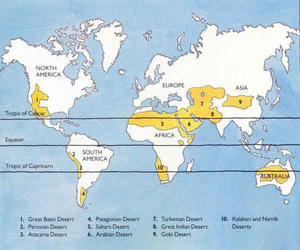
The Earth has a total landmass of 57.5 million square miles and the landmasses are disproportionate between the 2 hemispheres. In the northern hemisphere there is a 1:1.5 landmass to water ratio compared to a 1:4 ratio in the southern hemisphere. In the northern region there is 38.7 million square miles of land compared to the southern hemisphere having 18.8 million square miles. When we subtract Antarctica, which is covered in ice, we find there is 13.4 million square miles of open land in the southern hemisphere, 3 times less than the north. In the southern hemisphere we also find vast uninhabitable regions, such as the Atacama Desert of Chili and the Australian Outback consuming 2.54 million square miles alone between them, or 19% of this available land. This is the result of the southern hemispheres summer occurring while the planet is closest to the sun. Due to land availability and the heat inland we find that only 10% of the worlds population exists in this region.
The amount of energy the oceans provide in the southern hemisphere allows the planet to absorb and release much of this energy between seasons creating a less extreme environment when compared to areas in the north along the same latitudes. A comparable understanding would be the difference between Washington DC and Melbourne Australia. Both are coastal cities near the same latitude yet Washington DC averages a high of 89 in the summer and lows averaging 29 in the winter. In comparison, Melbourne averages a high of 78 degrees during their summer and an average low of 43 during their winter months. Due to land distribution and the climates inland, 90% of the population resides north of the equator.
As the axis of the Earth alters for a change of seasons, one pole freezes while the other thaws. This is a vital cycle allowing for the fresh cold water to sink to the bottom of the ocean constantly replenishing the cool water supply deep into the oceans to cool the core. This gradually warms and rises to the surface producing our surface weather and jet steams known as the Great Ocean Conveyer Belt. It's this difference in the oceans temperatures between the poles and the tropics that drives this conveyer and the seasonal changes continually refuel it. This in turn alters and changes the surface jet streams and is the major driving force in our weather.
Woody
Member
Proximity to the ocean?
You show me these vague pics of contrails and clouds with no evidence to support it as I have? May I remind you of this earlier report that supports me!Woody,the evidence of other chemtrail believers is against you. At this thread I present eight photos of persistent contrails taken near your area NINE YEARS before you ever noticed them. The evidence shows that you probably didn't "notice" them not because they didn't exist before 2010, before 2001, or even before 1991, you probably did notice them because someone told you they were "chemtrails".
") https://ams.confex.com/ams/13ac10av/techprogram/paper_39764.htm It is clear that these occasional anomalies that do exist are now daily here. Mine are more than just pics, they are evidence of flights where 100% are not commercial flights, angles, trajectories and evidence of same trail over time, and some contrails too for comparison. No where in these reports does it indicate two types of trails in the skies on the same day, trails dispersing while others maintained for hours never appearing to dissipate. Remember, I am not associated with chemtrail activists.
https://ams.confex.com/ams/13ac10av/techprogram/paper_39764.htm It is clear that these occasional anomalies that do exist are now daily here. Mine are more than just pics, they are evidence of flights where 100% are not commercial flights, angles, trajectories and evidence of same trail over time, and some contrails too for comparison. No where in these reports does it indicate two types of trails in the skies on the same day, trails dispersing while others maintained for hours never appearing to dissipate. Remember, I am not associated with chemtrail activists.
Last edited by a moderator:
solrey
Senior Member
May I remind you of this earlier report that supports me!
Why do you think that study supports you when in fact it seems to contradict you? That research demonstrates that on Oct. 9 2000, ten years before you started noticing persistent spreading contrails, there were persistent spreading contrails lasting at least 3 to 4 hours that formed a layer of contrail cirrus that lasted 14 hours. Not all flights left contrails and not all contrails could be matched to a commercial flight. However a plethora of persistent spreading contrails were matched to commercial flights. Their flight matching methodology was much more sophisticated than yours. Did you even read the extended abstract because it does not support your claims.
Now how does that support your claims that persistent contrails were not seen until 2010 and that those persistent contrails can not be matched to any known commercial flights? You also claim that winds always blow contrails in the same direction, generally west to east, yet in this study the contrails were blown to the southwest.External Quote:The flight tracks were matched using a contrail-centered geographic system assuming a circular earth. The contrails were divided into linear segments and a great circle arc through each segment was found using a series of geometric vector operations. This great circle arc serves as the "equator" of the new geographic system. In addition, a contrail segment-based "longitude" system was used to find the longitudinal distance (Dl) of each flight track point from another great circle arc placed perpendicular to the first great circle and centered on the westernmost end of the contrail segment.
For each time step, the shortest distance (Ds) of all possible flight track points (including current flights and flights advected from an earlier time) from the first great circle was computed. If the flight track does not extend across the longitudinal range of the contrail, the flight track is not considered. For all other flight tracks, Ds is found for all points inside the longitude range of the contrail, and averaged over that range. The flight track with the minimum average Ds is chosen as the flight track matching the contrail.
[..]
Figure 3 shows the matched flight tracks and contrail segments identified from the GOES-8 imagery at 1745 UTC. Several of the contrails are well matched to individual flights, although some trails cannot be well matched due to the presence of military flights and limitations in the flight advection/matching scheme. Good matches between the flight tracks and all of the contrails are unlikely due to uncertainties and errors arising from several sources. These include the initial flight track positions, the estimation of contrail location from the GOES imagery, and the advection of the flight tracks using the RUC model winds. The advection of the flight tracks is probably subject to the most uncertainty since the winds from a single pressure level are currently used, while the contrails are continually falling and are influenced by winds at different levels.
You also claim the skies are soooo hazy there, yet I'm not seeing it in your pics. I grew up in Indiana and remember well those hazy days of summer. Since then I've traveled to the four corners of the CONUS, literally, and visited each of the 48 states in the CONUS. You think your skies are hazy, you should visit the Pacific Northwest some time.
solrey
Senior Member
In the southern hemisphere we also find vast uninhabitable regions, such as the Atacama Desert of Chili and the Australian Outback consuming 2.54 million square miles alone between them, or 19% of this available land. This is the result of the southern hemispheres summer occurring while the planet is closest to the sun. Due to land availability and the heat inland we find that only 10% of the worlds population exists in this region.
OK, right there demonstrates that you don't know what you're talking about and there are plenty of other examples. There are a variety of factors that produce the deserts, which occur in two bands that straddle the tropic of capricorn and the tropic of cancer. The occurrence of arid regions in the southern hemisphere has nothing to do with the Earth at perihelion and there are vastly more vast arid regions in the NH than in the SH! As for uninhabitable, I've got some pictures of ancient cliff dwellings from the American desert southwest, or you could talk to an Aborigine, if you still want to contend that these areas are "uninhabitable".
http://faculty.unlv.edu/landau/desertgeography.htm
Last edited by a moderator:
Hama Neggs
Senior Member
There's a test for that.
http://psychometrics.akresgr.org/spatialtest/
Let us know how you do Woody.
11 of 19 for me. I really thought I had done better. I find I have no desire to try the "Woody" test.
Woody
Member
Weather modification has been in operation since the late 1940's, so different visuals are available since this time and one would have to go back to those days and determine many factor, and most evidence would be gone. This brings us to science today and our understanding of clouds
You've missed my entire point, this is one day, not daily.Why do you think that study supports you when in fact it seems to contradict you? That research demonstrates that on Oct. 9 2000, ten years before you started noticing persistent spreading contrails, there were persistent spreading contrails lasting at least 3 to 4 hours that formed a layer of contrail cirrus that lasted 14 hours. Not all flights left contrails and not all contrails could be matched to a commercial flight. However a plethora of persistent spreading contrails were matched to commercial flights. Their flight matching methodology was much more sophisticated than yours. Did you even read the extended abstract because it does not support your claims.
Now how does that support your claims that persistent contrails were not seen until 2010 and that those persistent contrails can not be matched to any known commercial flights? You also claim that winds always blow contrails in the same direction, generally west to east, yet in this study the contrails were blown to the southwest.External Quote:The flight tracks were matched using a contrail-centered geographic system assuming a circular earth. The contrails were divided into linear segments and a great circle arc through each segment was found using a series of geometric vector operations. This great circle arc serves as the "equator" of the new geographic system. In addition, a contrail segment-based "longitude" system was used to find the longitudinal distance (Dl) of each flight track point from another great circle arc placed perpendicular to the first great circle and centered on the westernmost end of the contrail segment.
For each time step, the shortest distance (Ds) of all possible flight track points (including current flights and flights advected from an earlier time) from the first great circle was computed. If the flight track does not extend across the longitudinal range of the contrail, the flight track is not considered. For all other flight tracks, Ds is found for all points inside the longitude range of the contrail, and averaged over that range. The flight track with the minimum average Ds is chosen as the flight track matching the contrail.
[..]
Figure 3 shows the matched flight tracks and contrail segments identified from the GOES-8 imagery at 1745 UTC. Several of the contrails are well matched to individual flights, although some trails cannot be well matched due to the presence of military flights and limitations in the flight advection/matching scheme. Good matches between the flight tracks and all of the contrails are unlikely due to uncertainties and errors arising from several sources. These include the initial flight track positions, the estimation of contrail location from the GOES imagery, and the advection of the flight tracks using the RUC model winds. The advection of the flight tracks is probably subject to the most uncertainty since the winds from a single pressure level are currently used, while the contrails are continually falling and are influenced by winds at different levels.
You also claim the skies are soooo hazy there, yet I'm not seeing it in your pics. I grew up in Indiana and remember well those hazy days of summer. Since then I've traveled to the four corners of the CONUS, literally, and visited each of the 48 states in the CONUS. You think your skies are hazy, you should visit the Pacific Northwest some time.
Woody
Member
What don't you understand? Its the planets orbit, during the northern hemisphere's winter we are closer to the sun, this means the southern hemisphere is in the middle of the summer, meaning more intensity due to the distance from the sun. In the summer we are further away from the sun in the north, meaning the south is in the winter and we are further away from the sun making their winter months cooler. As a result the southern hemisphere endures more extreme temperatures, but the oceans absorb and radiate much of this causing the differences in temperature variations. I love the distraction but if we can come back around to the topic of discussion. I was only trying to explain the oceans impact on climates, and Washington DC and Melbourne are on the same latitudes with the exception of one in the North and one in the south. So, explain this if you can.OK, right there demonstrates that you don't know what you're talking about and there are plenty of other examples. There are a variety of factors that produce the deserts, which occur in two bands that straddle the tropic of capricorn and the tropic of cancer. The occurrence of arid regions in the southern hemisphere has nothing to do with the Earth at perihelion and there are vastly more vast arid regions in the NH than in the SH! As for uninhabitable, I've got some pictures of ancient cliff dwellings from the American desert southwest, or you could talk to an Aborigine, if you still want to contend that these areas are "uninhabitable".
http://faculty.unlv.edu/landau/desertgeography.htm
Last edited by a moderator:
solrey
Senior Member
The difference in solar insolation between aphelion and perihelion is only 6 or 7 percent. The difference between the climates in DC and Melbourne are a factor of ocean currents and prevailing winds, but the effect of a difference in solar insolation is negligible.
And I really resent you talking to us like we're stupid, especially when most of us are clearly better informed than you.
And I really resent you talking to us like we're stupid, especially when most of us are clearly better informed than you.
Last edited:
Woody
Member
So the water mass in the south compared to the north has no influence? Why the warmer jet streams in the south than the north?The difference in solar insolation between aphelion and perihelion is only 6 or 7 percent. The difference between the climates in DC and Melbourne are a factor of ocean currents and prevailing winds, but the effect of a difference in solar insolation is negligible.
cloudspotter
Senior Member.
View attachment 4446A short time later that can aid in viewing its trajectory
So how far away do you think the part of the trail below the cross hairs is and why do you think that?
Ross Marsden
Senior Member.
I scored 13 of 19.11 of 19 for me. I really thought I had done better. I find I have no desire to try the "Woody" test.
I would like to know which category with which I had the most trouble.
Maybe if I had put some Mozart on the Hi-Fi, I would have done better...
According to this http://www.sciencedaily.com/releases/2010/05/100510075415.htm, probably not.
Ross Marsden
Senior Member.
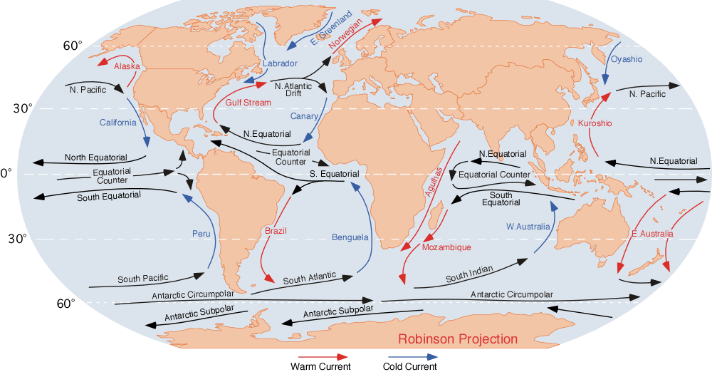
So the water mass in the south compared to the north has no influence? Why the warmer jet streams in the south than the north?
I think Woody is asking "Why are there only 2 warm ocean currents in the Northern Hemispahere and 3 in the Southern Hemisphere"?
Woody, notice that all the circulatioins are in the same direction in relation to the rotation of the Earth, anticyclonic; they are called gyres.
Now notice that there are 2 main land masses in the Northern Hemisphere (North America, Africa/Europe/Asia), and 3 in the Southern Hemisphere (South America, Africa, Australia).
You now have the answer to your question.
Jay Reynolds
Senior Member.
I can't argue with your statement, Woody. You and the other chemtrails people are showing vague pics of contrails and clouds with no evidence to support that they are anything unusual at all.You show me these vague pics of contrails and clouds with no evidence to support it as I have?
Jay Reynolds
Senior Member.
Woody, if you can see this sort of detail, where are the pictures of these planes? It's been 9 months we've been waiting. It it true that you were sort of stretching things back then? Are you now as well?Woody said:You can judge altitude the same way you can judge the distance of auto's with binoculars, by the size and location of the image. We have seen them higher, the same altitude, and lower. We were talking with a skeptic on a job site and he was denying it as many here are, then we asked him to look again at the plane flying near the same altitude and asked, where is the trail on that flight. We left him speachless and thinking. Anyone who has eyes can see them, including the chemical tanks mounted on the side of the planes on many of them here. They appear to be DC-9's with orangish tanks mounted on the sides of the aircraft behind the front wing reaching back to the tail on both sides and was appearing to be spraying from the wings.
Woody
Member
Woody, if you can see this sort of detail, where are the pictures of these planes? It's been 9 months we've been waiting. It it true that you were sort of stretching things back then? Are you now as well?
I'm not a chemtrail people, within this thread I am providing evidence of something occurring outside the norm, and maintain that this has been viewed over the past few years. Mind control and other conspiracies, give me a break. This entire article began about global dimming and the cooling effect it had, which was isolated more to the northern hemisphere than the southern. Logic does indicate that increasing global dimming once again could offset the warming that we are experiencing from the higher levels of CO2, at least its a logical assessment and would support the visual observations we are seeing. Nothing anyone else is saying seems logical nor supportive in these visual findings nor has anyone been able to explain actions that the US claims to be doing in battling global warming, or why they may possibly do it. As I may reiterate, I am NOT a CHEMTRAIL Activist!I can't argue with your statement, Woody. You and the other chemtrails people are showing vague pics of contrails and clouds with no evidence to support that they are anything unusual at all.
Woody
Member
With anything, a 6 to 7 percent rise means a 6 to 7 percent increase in heat, plus a reduction of 6 to 7% during the winter making the weather alter 12 to 14 percent per season. Researching the Earths history and times of such reduction can be displayed during times of the "Dalton and Maunder Minimum's" Yet, with this alteration it remains more stable because of the massive water that absorbs vast amounts of energy. Habitable, which is selective, and arable land coexist in past history. The Sahara has the Bedouin, the Arctic has the Eskimos, and according to the UN all of Canada and Siberia are habitable, after all, people do live there. Yet we do not find major population densities in these regions either, few live there because of the extreme temperatures along with limited resources available. Today, we can agree, we can even live in Antarctica, but where we can't produce food, there will be limited growth potential, and this was the driving force in mans history.The difference in solar insolation between aphelion and perihelion is only 6 or 7 percent. The difference between the climates in DC and Melbourne are a factor of ocean currents and prevailing winds, but the effect of a difference in solar insolation is negligible.
And I really resent you talking to us like we're stupid, especially when most of us are clearly better informed than you.
Woody
Member
Which pic? Unsure which one you are referring to.So how far away do you think the part of the trail below the cross hairs is and why do you think that?
Similar threads
- Replies
- 3
- Views
- 1K
- Replies
- 5
- Views
- 1K
- Replies
- 3
- Views
- 1K