Woody's observations of contrails in MN

But today was the best. upload_2013-10-28_21-20-52.jpegupload_2013-10-28_21-21-51.jpegupload_2013-10-28_21-22-26.jpegupload_2013-10-28_21-22-52.jpeg

These 2 are the same showing how they develop.
And when we left Duluth they were displaying a good show.
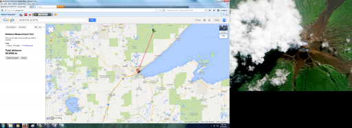
upload_2013-10-28_21-24-23.jpegupload_2013-10-28_21-24-59.jpeg
Tandem.

upload_2013-10-28_21-25-41.jpeg

And to show you, the standard contrails from identifiable aircraft were visible too. Some were long, all dissipated.upload_2013-10-28_21-27-14.jpeg I know this didn't come in well, we were on the move and sun was going down. But here is another contrail, hard to see because its size os so much smaller.
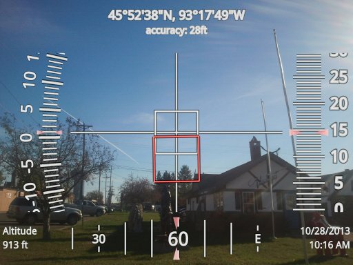
upload_2013-10-28_21-29-22.jpeg
 

Attachments

  • upload_2013-10-28_21-19-58.jpeg
    upload_2013-10-28_21-19-58.jpeg
    3.6 MB · Views: 585
As I have said, nearly every day when the sky does clear these are in the sky somewhere, just drive and you will find them. In the spring it seemed as if there was a break that corresponded to the same time the farmers lost their initial plant and had to plant a second time, the seeds molded in the ground due to lack of sun light and due to the reduced season that resulted, many turned to soybeans in Minnesota. Many fields not replanted were very visible from the air.
 
Only unidentified by you.....and then only because you apparently do not want to identify them since you have been given the tools to do so in this thread.
As you can see, they are daily regardless of the additional items you request, and both types of trails, those from known commercial flights and unidentified ones are available in these photos. If they don't show up on flightware, I mark them unidentified, I can't catch up to them, can you?
 
Woordy, c'mmon, how is it possible you still cant find this, it so easy, take the first one:


That is this flight:
http://www.flightradar24.com/2013-10-28/15:22/12x/ASA25

Flying at around 6.8 miles high it is about 10 miles away, which again perfectly matches your still not very well calibrated angle.

Now I've got three out of three of your 'unidentified' planes identified, if you want to continue this game at least get some better equipment like you showed months ago, also you still haven't told which plane you identified, you only say you have done so, but still no fligtradar link.
 
Last edited by a moderator:
And to show you, the standard contrails from identifiable aircraft were visible too. Some were long, all dissipated

Funny; this one I can't find that easily on flightradar, so I'm really curious which flight you think this was:
 
Last edited by a moderator:
Almost six months ago I showed Woody that flights from east coast destinations to Seattle passed very close to his area. I see one of these is among his pics.
Boston to Seattle.
http://www.flightradar24.com/2013-10-28/15:22/12x/ASA25

Just a few minutes shows the magnitude of commercial traffic over Woody's area.
-anything from San Francisco to Vancouver headed to the east coast airports and back will usually pass close
-any flights from vancouver and seattle to Chicago will usually pass close.

Sure there are many more. He needs to spend the day and quantify the extent of normal traffic, because if hundreds of flights/day pas over his area, how can 10-20 planes be spraying every day for weeks on end and nobody notices? Doesn't make sense, woody!

cyyz-cyvr.jpg

ksea-kewr.jpg

ksea-kord.jpg

ksfo-kbos.jpg
 
Almost six months ago I showed Woody that flights from east coast destinations to Seattle passed very close to his area. I see one of these is among his pics.
Boston to Seattle.
http://www.flightradar24.com/2013-10-28/15:22/12x/ASA25
I have no idea what picture your referring to with this flight, let me know which one you are referring too. Please remember, i did post some contrails to compare the other trails with so you should be able to find them. Also, when you are looking at the picture remember the distance factors discussed earlier. The flight paths you are sharing are way beyond the distance in the photos based upon the trig calculations by the degree of angle.
 
IMO Woody's pictures are just a bandwidth-wasting gish-gallop.
Yep Mike, to the trained observer, they are the same, or some atmospheric anomaly yet unexplained. But, they ALL do not come up on flightware, and mathematically at this point, this is virtually impossible given the probabilities of so many not identified, esp when you just want to find one! I am doing my best to discuss this.
 
Yep Mike, to the trained observer, they are the same, or some atmospheric anomaly yet unexplained. But, they ALL do not come up on flightware, and mathematically at this point, this is virtually impossible given the probabilities of so many not identified, esp when you just want to find one! I am doing my best to discuss this.

Woody- you still haven't addressed the fact that "normal" contrails often persist and spread...and often in the same sky as contrails that dissipate....Do you understand and accept these facts?
 
How about a little less talk and a little more action?
I give you locations, angle, trajectories date and times, and they are daily and all come from flights not showing up on Flightware. It is clear you are pulling crap out of hat and displaying it to create a reaction. I enjoy intelligent conversations over disrespectful arguments backed by someone who struggles with reading a map or verify the times and dates.
 
Yep Mike, to the trained observer, they are the same, or some atmospheric anomaly yet unexplained. But, they ALL do not come up on flightware, and mathematically at this point, this is virtually impossible given the probabilities of so many not identified, esp when you just want to find one! I am doing my best to discuss this.
Umm, excuse me, but could you address miss vocal cord's posts then?


(eta. sorry, wrote wrong poster name. There are no women on the internet.)
 
Woody- you still haven't addressed the fact that "normal" contrails often persist and spread...and often in the same sky as contrails that dissipate....Do you understand and accept these facts?
SR, yes I did address this in earlier posts, and sometimes I throw something out there to have you guys share the knowledge too. What is not common is the skies appearing like the above daily and all unregistered through flighttware, not one has been found leaving this specific trail on flightware, not one. They are distinctly different as the pictures demonstrate, and they are nearly every day, especially this time of the year. Every day this month so far for the sake of this thread, and the sky is clear, these trails exist, and so do the contrails, this is why I am displaying both. Here is a good one, contrail that is, and there is a 70% chance this one would be found in past flight logs. I am not being prejudice, I am displaying both on the very same days. Flying right over home depot in St. Cloud. upload_2013-10-29_16-13-3.jpegas long as this one is, it dissipated within minutes.
 
SR, yes I did address this in earlier posts, and sometimes I throw something out there to have you guys share the knowledge too. What is not common is the skies appearing like the above daily and all unregistered through flighttware, not one has been found leaving this specific trail on flightware, not one. They are distinctly different as the pictures demonstrate, and they are nearly every day, especially this time of the year. Every day this month so far for the sake of this thread, and the sky is clear, these trails exist, and so do the contrails, this is why I am displaying both. Here is a good one, contrail that is, and there is a 70% chance this one would be found in past flight logs. I am not being prejudice, I am displaying both on the very same days. Flying right over home depot in St. Cloud. upload_2013-10-29_16-13-3.jpegas long as this one is, it dissipated within minutes.

So- to be clear- you know and understand that normal contrails from normal and identifiable planes often persist for hours and spread- correct?

If yes, then why do you suspect something nefarious with the trails simply because you cannot identify the plane? The trails you observe behave identically to "normal" contrails.

Moreover, it appears Miss Vocal Cord identified the planes that you were unable to....
 
Remember guys, when you are calculating distance and location from a picture, the size of my camera is a 52 degree angle of view with no zoom. With the horizon centered in the photo you would have a 26 degree field of view of the sky. A plane traveling at 30,000 feet would be only 12.92 miles away when it is no longer viewed by the camera and you will need to lift the camera away from the horizon as it draws closer. This should give you some idea as to my location and distance of these aircraft along with the times.
 
So- to be clear- you know and understand that normal contrails from normal and identifiable planes often persist for hours and spread- correct?

If yes, then why do you suspect something nefarious with the trails simply because you cannot identify the plane? The trails you observe behave identically to "normal" contrails.

Moreover, it appears Miss Vocal Cord identified the planes that you were unable to....
No, they are not normal, thus the scientific paper explaining this abnomality. It happens, but is rare and not daily. Today it is daily and what is rare is no trails in the sky, its backwards. Often times there are no contrails and just these trails.
 
Yep Mike, to the trained observer, they are the same, or some atmospheric anomaly yet unexplained. But, they ALL do not come up on flightware, and mathematically at this point, this is virtually impossible given the probabilities of so many not identified, esp when you just want to find one! I am doing my best to discuss this.

you are not discussing it at al.

If you have actually looked at hem on FA or similar then you should be able to plot your ground position on a map, show the direction you are looking, and the lack of a suitable a/c on the display for that time.

But you do not.

So I do not think you are actually making ANY effort to locate these on any flight reporting system - because her is no evidence that you have done so.
 
No, they are not normal, thus the scientific paper explaining this abnomality. It happens, but is rare and not daily. Today it is daily and what is rare is no trails in the sky, its backwards. Often times there are no contrails and just these trails.

This comment exposes the heart of your misunderstanding and misinterpretation of what you are observing.

Contrails that persist for hours and spread are common. They have been common and frequently observed since planes have flown high enough.

Before you can comment on what you think you see int he sky you need to understand the very nature and physics of contrail formation and persistence- its causes and frequency etc...

I know for a fact it doesn't happen "everyday"- I was in Mpls in July and experienced several trail free days.

Woody- why do all these papers dating back decades characterize persistent, spreading contrails as "frequent" and "common" if they are supposedly rare?

What do you make of all this research that contradicts your beliefs?? :

http://contrailscience.com/persisting-and-spreading-contrails/
 
I have no idea what picture your referring to with this flight, let me know which one you are referring too. Please remember, i did post some contrails to compare the other trails with so you should be able to find them. Also, when you are looking at the picture remember the distance factors discussed earlier. The flight paths you are sharing are way beyond the distance in the photos based upon the trig calculations by the degree of angle.
For identification see my posts:
https://www.metabunk.org/threads/woodys-observations-of-contrails-in-mn.2484/page-9#post-72702
and
https://www.metabunk.org/threads/woodys-observations-of-contrails-in-mn.2484/page-9#post-72704

You also said you identified the flight in this picture:
https://www.metabunk.org/threads/woodys-observations-of-contrails-in-mn.2484/page-9#post-72707

Please give a fligtradar link or something alike, because up till now you haven't shown any identification you have been able to make
 
Last edited by a moderator:
Remember guys, when you are calculating distance and location from a picture, the size of my camera is a 52 degree angle of view with no zoom. With the horizon centered in the photo you would have a 26 degree field of view of the sky. A plane traveling at 30,000 feet would be only 12.92 miles away when it is no longer viewed by the camera and you will need to lift the camera away from the horizon as it draws closer. This should give you some idea as to my location and distance of these aircraft along with the times.

Woody,
You are talking absolute gibberish. It is clear that the contrail you have photographed was produced by the Alaskan Airlines Boeing 737. Your post here shows exactly how confused you are over this issue. You are just making excuse after excuse and clearly confused.

http://uk.flightaware.com/live/flight/ASA25/history/20131028/1200Z/KBOS/KSEA

https://www.metabunk.org/threads/woodys-observations-of-contrails-in-mn.2484/page-9#post-72702

http://www.flightradar24.com/2013-10-28/15:22/12x/ASA25

Wood, please post the details of your camera or link to an internet image of the exact type.
 
Last edited by a moderator:
Woody,
I've just had a look through the exif on some of your images. So you are using a Samsung SGH-T959V? You do realise that the lens is 3.8mm. You are aware that this is wide angle? So you are informing this forum that a 3.8mm wide angle is not going to record Flight ASA25 from your filming location in Mora? Seriously?
 
And the 'tandem' flight:

My guess would be that the plane/contrail on the left is this one:
http://www.flightradar24.com/2013-10-28/22:07/12x/EVA651

The contrail on the right seems to be older, also displayed in the second picture where it is dissolved in certain places and nowhere a real 'tip' (plane) of the contrail can be seen.
http://www.flightradar24.com/2013-10-28/22:07/12x/CKK240

Four out of four.... (or I guess more five out of five)
It takes some time to reference these, This is not this flight or the other 2 before them, they are flying NW, these are going NE and for further confirmation look at the coordinates where the picture was taken and if you see the highway, thats 35 heading NE, these other flights are going in another direction Plus, you have to start it earlier, http://www.flightradar24.com/2013-10-28/22:07/12x/EVA651 See anything traveling NE as the pic identifies through the compass and land markers?
 
Last edited by a moderator:
I give you locations, angle, trajectories date and times, and they are daily and all come from flights not showing up on Flightware. It is clear you are pulling crap out of hat and displaying it to create a reaction. I enjoy intelligent conversations over disrespectful arguments backed by someone who struggles with reading a map or verify the times and dates.

It looks to me you are throwing a lot of stuff at the wall, thinking something will stick.
 
Has anyone tested the accuracy of flightradar? Are they accurate ties or delayed like Flightware, or is it adjusted for accuracy later and only live is delayed?
 
Funny; this one I can't find that easily on flightradar, so I'm really curious which flight you think this was:
I'm not sure on this one either, it looked like all the other contrails out there this day. It was heading NW SE just south of our position, compass must not have calibrated rightupload_2013-10-29_21-35-32.pngBased upon a 32 degree angle, and if it was flying at 38,000 feet, the plane would be 13.59 miles away from my position placing it at the above shot at the time of the photo. Guess it was one of the unidentified ones, so it could be anything.
 
Last edited by a moderator:
Woody,
You are talking absolute gibberish. It is clear that the contrail you have photographed was produced by the Alaskan Airlines Boeing 737. Your post here shows exactly how confused you are over this issue. You are just making excuse after excuse and clearly confused.

http://uk.flightaware.com/live/flight/ASA25/history/20131028/1200Z/KBOS/KSEA

https://www.metabunk.org/threads/woodys-observations-of-contrails-in-mn.2484/page-9#post-72702

http://www.flightradar24.com/2013-10-28/15:22/12x/ASA25

Wood, please post the details of your camera or link to an internet image of the exact type.
I do not agree but I do agree that I should have taken a shot of that flight to compare them, I won't make this mistake again. Had I, it would have silenced the audience, this is why next time I won't miss it. Look at the above post, these are the contrails they are all making this day.
 
Last edited by a moderator:
Based upon photo location of those 2 flights and trajectory, at the time of the pic it can be determined that this is the location of the flight and we will assume they are at 38,000'. In the following pic Lake Superior is to the Right and the pic is taken back behind us while we are heading south on 35. Trajectory is almost straight North but coming in land slightly away from the lake. This was taken at the top of the hill. upload_2013-10-29_22-1-33.jpeg
 

Attachments

  • upload_2013-10-29_21-57-14.png
    upload_2013-10-29_21-57-14.png
    2.4 MB · Views: 476
upload_2013-10-29_22-5-58.pngHere is where the plane would beupload_2013-10-29_22-17-47.pngHere the center dot is the location where the photo was taken, the green dot on the top is the estimated location of the plane if it was flying at 38,000'. It originated within just a few miles east of our original work site located in Superior Wisconsin, they were nearly overhead. The line is a very close estimation as to the trajectory of the aircraft. The first one was further East and occurred while we are at the site while the second had just appeared.
 
upload_2013-10-29_22-33-28.jpeg9 minutes after the previous photo, within 9 miles, (lost GPS signal) this shot was taken demonstrating the contrails present, perhaps this is one of those planes, but by trajectory and angles, this one appears to not be identified either. We had still not entered Cloque. He is heading NNE.
 
Seems like people are throwing out info thinking it will stick, question is, who is debunking who?
Thats what they do along with little innuendos on your lack of understanding . basically insulting you . Keep it up and dont give up . :)
 
Wodoy, It is possible to determine the angle of the trail relative to the view direction from data measured in the photo and knowing some information about focal length, and elevation of view and the roll angle of the camera. I don't know how to do that, but such calculation would very much be simplified by you ensuring to be careful that the roll angle (left scale) is exactly zero. One thing with the scales... the elevation scale is probably "to scale" meaning that 0 will always be on the horizon. However, the baring scale is not to scale in that a difference of say 10 degrees on the scale does not mean the same angle subtended in the scene.

Obviously if the trail is horizontal in the photo, the angle relative to the view direction of the trail will be 90 degrees. If the trail is vertical, its direction is the same (or the reciprocal) as the view direction. What happens in an intermediate case, I don't know.

In your posts #353 and #354 you are suggesting that there is only about 20 degrees between the direction of the left trail and the view direction. I suggest it is a lot more than that, even when the camera roll is corrected. And I don't think the trail to right is parallel to the left one, even taking perspective into account. Perspective is the key to this.

Does anyone know how to do the photogrametry here?
 
It takes some time to reference these, This is not this flight or the other 2 before them, they are flying NW, these are going NE and for further confirmation look at the coordinates where the picture was taken and if you see the highway, thats 35 heading NE, these other flights are going in another direction Plus, you have to start it earlier, http://www.flightradar24.com/2013-10-28/22:07/12x/EVA651 See anything traveling NE as the pic identifies through the compass and land markers?

Now I"m confused, this is as far as I can determine the spot where the photo was taken (as close as google streetview can get it):
https://maps.google.nl/maps?q=46+43...89z8D_SdiDTjTXxwetSGg&cbp=12,303.38,,1,-10.59
and
https://maps.google.nl/maps?q=46+43...V4K6zW5by6NzLZScC2dcQ&cbp=12,318.88,,1,-12.82

So the picture is taken looking to the NNW, no East at all in there. If not provide the same as above in google streetview from the point of view taken.

See anything traveling NE as the pic identifies through the compass and land markers?
No since as far as I"m concerned you're looking to the NNW these planes also fly to the NW, exactly the ones I identified. And again it is suprising that exactly at the same time at the same place two/three planes which could be identified as such suddenly don't match your criteria, exactly with the other planes I have identified.
 
Guess it was one of the unidentified ones, so it could be anything.
Now you really have lost most of your credibility as far as I'm concerned, just yesterday this plane was:
And to show you, the standard contrails from identifiable aircraft were visible too. Some were long, all dissipated.
So first you can identify it, but then if you have to provide the details it suddenly is no longer, I'm sensing some pattern here; a lot of shouting, but 0% evidence...

So you still haven't been able to provide a positive identification on a plane you said you made, please do so.
 
In the following pic Lake Superior is to the Right and the pic is taken back behind us while we are heading south on 35.
This is the location of the first picture:
46 43 15 N, 92 7 5 W , taken at 5:07PM
https://maps.google.nl/maps?q=46 43 15 N, 92 7 5 W&hl=en&ll=46.730743,-92.142935&spn=0.044182,0.069952&sll=46.732331,-92.134352&sspn=0.044181,0.069952&t=h&gl=nl&z=14

This is the second picture:
46 44 27N, 92 9 7 W, taken at 5:08
https://maps.google.nl/maps?q=46 44 27N, 92 9 7 W&hl=en&ll=46.731684,-92.139072&spn=0.044181,0.069952&sll=46.737508,-92.140446&sspn=0.088353,0.139904&t=h&gl=nl&z=14

So according to the coordinates from your pictures you are on "2" moving NW


This was taken at the top of the hill.
Now there might be some language I'm misunderstanding here, but you are here when this picture was taken:
https://maps.google.nl/maps?q=46 44 27N, 92 9 7 W&hl=en&ll=46.740934,-92.151926&spn=0.011043,0.017488&sll=46.737508,-92.140446&sspn=0.088353,0.139904&t=h&gl=nl&z=16&layer=c&cbll=46.741122,-92.152088&panoid=9HH0MVY02kuQGxYRz6_3QA&cbp=12,321.16,,0,7.48

Why would you describe this bridge/passover as a 'hill'?
 
Last edited:
Back
Top