The NERC funded MST Radar facility in Wales is not a HAARP installation

David Fraser

Senior Member.
Recently a very unassuming atmospheric radar research facility in Wales has come under scrutiny of some of the UK chemtrail community.

Headlines like this are abound:

http://philsreport.blogspot.co.uk/2014/02/david-cameron-authorized-haarp-facility.html

David Cameron authorized HAARP facility in WALES that engineered UK floods!

The massive floods throughout the British isles were not natural and here is the proof!


Watch this first video (author's own website) to see satellite images of a HAARP facility built in utmost secrecy by the Bilderberg led coalition government in the UK.
The facility is just outside Aberystwyth in Wales covering several acres with arrays that send up microwaves into the stratosphere and warm up the upper air to disturb our normal weather pattern.
Combined with the "chemtrails" that we have seen all over the UK for the last several years which contain metal particles that react to the magnetic waves produced by the HAARP facility to cause massive rainfall, high winds and even earthquakes.
So you people who have been flooded out of your homes, had cars and boats and other property wrecked should now sue the "New World Order" government in London for massive damages.
Not only that but use social media to pass on this message to all others to warn them of the dangers of further floods, earthquakes and storms to come from this facility.
Start campaigning for the removal of the Prime Minister, David Cameron, he is responsible,for allowing this facility to exist in Wales and the "chemtrails" over our heads which could also affect the health of everyone in the nation with the intake of metal particles into their lungs.
Take action now! Keeping silent makes cowards of us all!
Tony Dean

http://www.rantonuk.org.uk/storms-generated-in-wales-uk-your-own-govt-are-traitors/
http://www.rantonuk.org.uk/
Content from External Source
A letter was even posted in a local newspaper

http://www.centralsomersetgazette.c...tory-20644106-detail/story.html#ixzz2tg7ygchW

THE latest conspiracy theory behind flooding in England arguably trumps claims that the deluge in Somerset is caused by gay marriage and the EU. Reader and blogger Tony Dean of Rant on UK! blames it on a secret weather controlling facility in South Wales.

All words and opinions are very much his own.
Content from External Source
Now the rumours have been around for a couple of years and even Geoengineering Watch list the facility as HAARP like;

http://www.geoengineeringwatch.org/haarp-coordinates-and-explanation/

Nerc MST Radar Facility

Capel Dewi, Carmarthenshire, Wales, United Kingdom

Near Aberystwyth, Wales, UK

+52° 25’ 28.26”, -4° 00’ 19.59”
Content from External Source
At present there are even plans to protest at the site, which has earned the ire of some local people
https://www.facebook.com/events/1411253589100893/1499217466971171/?notif_t=event_mall_reply

So what exactly is this place. Well it is just what it says on the tin and definitely not an Ionospheric Heater. It is a weather radar facility that is funded by NERC (Natural and Environmental Research Council) and mainly operated by the Universities of Aberystwyth and Manchester as well as the Rutherford Appleton Laboratory, with MST standing for Mesosphere-Stratosphere-Troposphere. In addition it has a wind profiler.


The NERC MST Radar Facility at Aberystwyth:
  • is a research station operated on behalf of the UK's atmospheric science community
  • is located at Capel Dewi (52.42°N, 4.01°W) near Aberystwyth in west Wales (UK)
  • operates the NERC Mesosphere-Stratosphere-Troposphere (MST) Radar, the UK's most powerful and versatile wind-profiling instrument
  • operates a number of auxiliary instruments
Content from External Source
Their main page is here: http://mst.nerc.ac.uk/ However a Google search will find a wealth of information and data. For the technically minded they provide the technical specifications e.g.

http://mst.nerc.ac.uk/nerc_mstr_tech_spec.html

Operating frequency/radar wavelength
46.5 MHz/6.45 m
Peak transmitted power
160 kW (from 5 Tycho Technology WPT-50 transmitters)
Transmitter pulse lengths, us (range resolutions, m)
1 (150), 2 (300), 4 (600), 8 (1200), 16 (2400), 32 (4800)
Complementary pulse coding available for 4 us and longer pulses
Inter-pulse periods, us (maximum unambiguous ranges, km)
80 (12), 160 (24), 320 (48), 640 (96)
Maximum duty cycle
5 %
Antenna type
20 × 20 array of 4-element Yagis, 0.85 λ spacing
Antenna dimensions
109.6 × 109.6 m
Location of the antenna arrray
Latitude 52.42°N, Longitude 4.01°W, 50 m above mean sea level
British National Grid Reference SN 637 826
Available beam pointing directions
N4.2°, E4.2°, S4.2°, W4.2°
NE6°, SE6°, SW6°, NW6°,
N8.5°, E8.5°, S8.5°, W8.5°
NE12°, SE12°, SW12°, NW12°
where the actual azimuths are offset 17.5 °, anticlockwise from the nominal directions
Minimum coherent integration time
81.92 ms
Avaialble discrete Fourier transform lengths
64, 128, 256, 512
Content from External Source
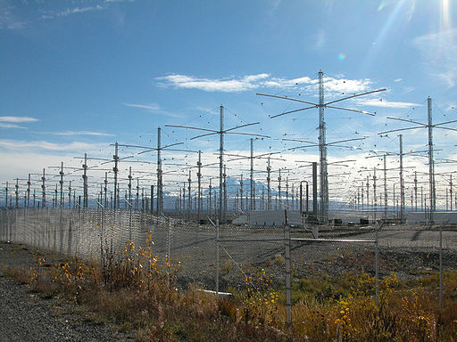
The facility has been up and running since 1990 and there has been nothing secretive about it. When challenged as to how this is anyway comparable to HAARP the answer is "the layout and antenna". The facility uses Yagi antenna which have been in use since the 1920s http://en.wikipedia.org/wiki/Yagi-Uda_antenna However the array at HAARP is over 70 ft high, and the MST is 5 or 6ft. HAARP has a peak power of 3.6 MW and the MST is 160 KW. They even use different frequencies in their work. To give an idea of the size there is a rather good shot here.

tr_mst_radar_hr.jpg

Take note of the lack of security and massive power generators. I think it is safe to say this is not controlling the recent floods and bad weather in the UK.
 
We are devolving to an era of darkness, where everything that we do not understand is automatically evil and must be destroyed. We did that in the past with witches and philosophers, and it's happening again. The only good part is that those who decide to "take actions", do so by creating blogs and videos or sitting in their houses and commenting in YT about their rage instead of doing something physically.

The new era of information is both a bless and a curse. I sometimes kind of prefer the good ol' times when you could blame the devil for floods, sickness and broken heart. Now that we have lots and lots of information we know that the devil does not exist or is too busy with greater evildoings, and we need to find new devils to blame: NWO, illuminatti and "the government" - entities as subjective as the good ol' devil.
 
Has the protest been cancelled? I'm not finding it on facebook anymore.
Yeah the group is still there but they have changed the settings to "invite only" and there is no discussion allowed.

The police have been infromed as well the management. I noticed recently David Lim brings the place up in his "talks" but then goes to talk about the HAARP facility.
 
Isn't that one of the UK's famous attack sheep in the foreground?
Yeah but after the recent cuts it is just a reservist attack sheep and has only received a portion of the training of the regulars. In line with recent doctrine it also has to dual role as security for the coming Commonwealth Games.
 
Video of the protest, about six people. They have a nice chat with some local police.


Wow, the guy actually compares contrails forming from jet engines to mountain climbers ascending Mt Everest, and the lack of visible breath from their mouths. (around 10:50).
 
31:25 "Jesse Ventura... met with fierce security presence... they were very hostile towards him..."

Classic! Conspiracy theorists remembering things completely differently than what actually happened! Jesse had to use a call button outside the gate because there wasn't, and never has been, a "security presence" at the facility. Then one guy who worked there came out to talk to him.

 
Just before that a guy said "It's only when it's -42 degrees, down here, which means it's -90 up there."

The Everest breath thing is interesting. I suspect it's because they only go up there in good weather, meaning low humidity, and not too cold. But it might also partly be a function of breathing (or trying to) in thin air. Most of the videos only show people in oxygen masks. They never climbs when it's cold enough for ice fog to form.
 
They seem to find it suspicious where it is sited. As far as I am aware the land is owned by the University of Aberystwyth as they have a major presence in the area. A few hundred yards away on the other side of the road is the Plas Gogerddan Campus of the university which also houses some of the research fields for the Institute of Biological, Environmental and Rural Sciences.
http://www.aber.ac.uk/en/ibers/about-us/
They are doing some interesting research in plant adaptations to climate change such as abiotic stress factors https://www.aber.ac.uk/en/ibers/res...c-stress-resistance-and-nutrient-use-efficie/ All public funded and open source but is this not the thing the chemtrailers claim is all owned by Monsanto.

Anyway back to my point. No it is not suspicious to place the facility a couple of hundred yards from a campus.
 
Just before that a guy said "It's only when it's -42 degrees, down here, which means it's -90 up there."

The Everest breath thing is interesting. I suspect it's because they only go up there in good weather, meaning low humidity, and not too cold. But it might also partly be a function of breathing (or trying to) in thin air. Most of the videos only show people in oxygen masks. They never climbs when it's cold enough for ice fog to form.

I had a few pilots that I fly with, climb Mt Kilimanjaro a few years back. They said their guides would get them acclimated to the thin air by taking them above 10,000 for a short time, then back down the mountain a short ways to get below it, before finally climbing further.

I thought I'd add the oxygen requirements for aircraft.

Screen Shot 2014-06-30 at 12.52.41 PM.png
 
Last edited:
Sounds nasty. Not the feeling threatened and special forces intimidation, but the 60mph (is that 120 combined or both doing 30?) head-on crash, espcially if all his advanced training wasn't able to help him avoid it.
 
Well I suspect the feeling threatened might have meant the driver was looking over his shoulder to see if the police were following when he failed to see the car coming in the opposite direction. I am certain though that the crash was purely an accident and not orchestrated by the powers that be.
 
Does England really use WSR-88D radars, or is he using NEXRAD as a generic name? That's a weird composite though. I'm not sure what caused it, but it's clearly an artifact instead of an accurate return.
 
He's using NEXRAD as a snarlword. NEXRAD is the entire system - of which the radar is only 1 component.

UK weather radars are currently being upgraded - see this pdf of a powerpoint presentation - the UK is using a range of products, some components are based on US designs (but WSR-88D isn't mentioned), but others designed and built in the UK.

This is the overview page of the upgrade itself:
Untitled.jpg
 
By "toned down microwave burst" do they mean less ground clutter?

Is it really possible they're complaining about a cleaner radar display?
 
Well they don't know the difference between infrared satellite imagery and radar imagery so I expect they can complain about anything they can imagine.

e.g. That post linked above:

NEXRAD Transmits beams from Troodos Mountains Cyprus into cloud formations
Content from External Source
That post shows no radar imagery. It is a very low resolution infrared satellite image. What it depicts is daytime convection occurring over the island with cirrus clouds blowing off the top of the convection. There is no beam. There is nothing remotely odd about it. It is a cloud that forms when the sun heats the land and causes the air to rise.

Whoops.

That's what I get for not bothering to watch the video. Yeah, confusing IR and radar is an even bigger boner... One I would have caught if I hadn't relied on the comments.
 
Harry explains how he is able to read the "NEXRAD Beams"

upload_2015-6-14_1-12-56.png
Except the WSR 88D actually has a frequency range of 2.7-3 GHz, as opposed to the 2.45Ghz of the microwave oven so it is not the same frequency.
This sounds like though that Harry Rhodes simply does not really know what a microwave is so seeing the satellite picks up microwaves, assumes it is always the same as a microwave oven.

As the satellite is actually picking up infrared,that is just outside the range of what is called microwaves, so the satellite image is not showing ANY microwaves, (even those at just under 300GHz, let alone those at only 2.4)
 
Even Harry is considering jumping on the Gofundme merry-go-round.

Harry needs to see the "wavelengths"

upload_2015-8-7_8-31-22.png


https://www.facebook.com/photo.php?...09736654227.1073741832.100008156444398&type=1

Harry is really ramping up his "analysis"

https://www.facebook.com/harry.rhodes.750?fref=photo

https://www.youtube.com/channel/UCIS7ej_kkga78aciuDD1Jsg/videos

Microwave arches? How powerful a microwave exactly do you need to alter a typhoon??

Does anyone know what these things really are? I am assuming artifacts of some kind?

 
I don't know the particulars of what that satellite imagery is measuring. I'll have to research that.

I do know that it is a composite image from a low earth orbit satellite. The satellite is in a polar orbit so it revolves around the earth top to bottom while the earth turns underneath. Therefore the images it generate are "stripes" that have to be merged together to form a composite image. The anomalies are post processing artifacts generally caused by data gaps that the computer tries to fill in to make the image "whole".

Looks like SSTs to me. I'd guess the two righthand stripes are areas where the thresholds are set differently; you can see the same effect from frame to frame on IR and WV imagery at times. Not sure of the left hand artifact.
 
Microwave arches? How powerful a microwave exactly do you need to alter a typhoon??

Does anyone know what these things really are? I am assuming artifacts of some kind?

Yeah, those are just artifacts. MIMIC-TPW maps are a combination of water vapor data from microwave sounders onboard, I think 3 different polar orbiting satellites, blended with a global wind circulation/advection model. A variety of artifacts have been recognized as an unavoidable consequence of the process.

The final product is a simple composite of many advected TPW swaths over a selected domain. Every pixel on the final composited image is a time-weighted average between the synthetic data originating from the shortest timespans before and after the image time.

The TPW retrieval algorithm does not produce TPW values over land. Without any further adjustments, the final product as described so far would show "shadows" of islands and continents advecting into the oceans. In order to eliminate these shadows, we apply an interpolation/extrapolation technique based on Bertalmío et al. (2000). The TPW retrieval algorithm also does not produce values in pixels with suspected precipitation. However, for our visualization purposes, we fill in these data gaps with high TPW values.

As stated above, this technique is highly sensitive to biases between the different satellite instruments' calibration and/or retrievals of TPW. Even slight differences between retrievals can create two easily discernable artifacts in the animation: 1) The appearance of data swath edges throughout the image domain, and 2) The apparent "pulsing" of various high-TPW areas, especially in areas of precipitation.
Content from External Source
http://tropic.ssec.wisc.edu/real-time/mimic-tpw/prodDesc/

Here we present a method of advective blending that combines data from several polar orbiting satellites and produces an effectively seamless and high temporal resolution final product. The demonstrative variable in this case is total precipitable water (TPW) derived from microwave frequencies.
Content from External Source
See section 5b for a discussion of error trends.

ftp://ftp.cira.colostate.edu/ftp/Kidder/201006221557515-16151.pdf
 
That band from about Japan to New Zealand is the shape of the image from a single pass projected onto a flat surface (narrowest at the equator and wider at higher latitudes). I can't tell you the cause but it has a lot of bad/missing data.
 
Being a biologist that only went as far as Calc Diff Eq 20 years ago (subsequently forgetting most of it) and that now does no math more complex than population modeling, I can safely say that the math that goes into blending microwave data and advection models to generate those images turns my brain to mush.
 
Here's a good animation showing the data swaths of a polar orbiting satellite. Now put three of those through a mathematical blender and you have MIMIC-TPW.

 
Back
Top