David Fraser
Senior Member.
Recently a very unassuming atmospheric radar research facility in Wales has come under scrutiny of some of the UK chemtrail community.
Headlines like this are abound:
http://philsreport.blogspot.co.uk/2014/02/david-cameron-authorized-haarp-facility.html
http://www.centralsomersetgazette.c...tory-20644106-detail/story.html#ixzz2tg7ygchW
http://www.geoengineeringwatch.org/haarp-coordinates-and-explanation/
https://www.facebook.com/events/1411253589100893/1499217466971171/?notif_t=event_mall_reply
So what exactly is this place. Well it is just what it says on the tin and definitely not an Ionospheric Heater. It is a weather radar facility that is funded by NERC (Natural and Environmental Research Council) and mainly operated by the Universities of Aberystwyth and Manchester as well as the Rutherford Appleton Laboratory, with MST standing for Mesosphere-Stratosphere-Troposphere. In addition it has a wind profiler.
http://mst.nerc.ac.uk/nerc_mstr_tech_spec.html

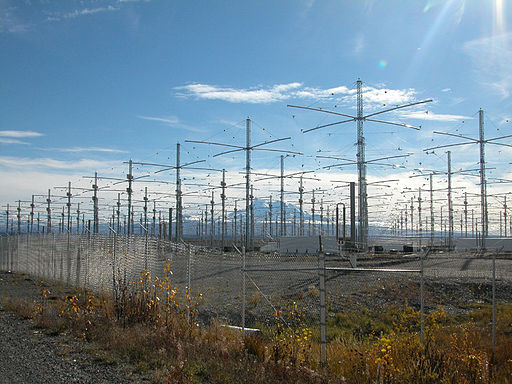
Take note of the lack of security and massive power generators. I think it is safe to say this is not controlling the recent floods and bad weather in the UK.
Headlines like this are abound:
http://philsreport.blogspot.co.uk/2014/02/david-cameron-authorized-haarp-facility.html
A letter was even posted in a local newspaper
David Cameron authorized HAARP facility in WALES that engineered UK floods!
The massive floods throughout the British isles were not natural and here is the proof!
Watch this first video (author's own website) to see satellite images of a HAARP facility built in utmost secrecy by the Bilderberg led coalition government in the UK.
The facility is just outside Aberystwyth in Wales covering several acres with arrays that send up microwaves into the stratosphere and warm up the upper air to disturb our normal weather pattern.
Combined with the "chemtrails" that we have seen all over the UK for the last several years which contain metal particles that react to the magnetic waves produced by the HAARP facility to cause massive rainfall, high winds and even earthquakes.
So you people who have been flooded out of your homes, had cars and boats and other property wrecked should now sue the "New World Order" government in London for massive damages.
Not only that but use social media to pass on this message to all others to warn them of the dangers of further floods, earthquakes and storms to come from this facility.
Start campaigning for the removal of the Prime Minister, David Cameron, he is responsible,for allowing this facility to exist in Wales and the "chemtrails" over our heads which could also affect the health of everyone in the nation with the intake of metal particles into their lungs.
Take action now! Keeping silent makes cowards of us all!
Tony Dean
http://www.rantonuk.org.uk/storms-generated-in-wales-uk-your-own-govt-are-traitors/
http://www.rantonuk.org.uk/
http://www.centralsomersetgazette.c...tory-20644106-detail/story.html#ixzz2tg7ygchW
Now the rumours have been around for a couple of years and even Geoengineering Watch list the facility as HAARP like;
THE latest conspiracy theory behind flooding in England arguably trumps claims that the deluge in Somerset is caused by gay marriage and the EU. Reader and blogger Tony Dean of Rant on UK! blames it on a secret weather controlling facility in South Wales.
All words and opinions are very much his own.
http://www.geoengineeringwatch.org/haarp-coordinates-and-explanation/
At present there are even plans to protest at the site, which has earned the ire of some local people
Nerc MST Radar Facility
Capel Dewi, Carmarthenshire, Wales, United Kingdom
Near Aberystwyth, Wales, UK
+52° 25’ 28.26”, -4° 00’ 19.59”
https://www.facebook.com/events/1411253589100893/1499217466971171/?notif_t=event_mall_reply
So what exactly is this place. Well it is just what it says on the tin and definitely not an Ionospheric Heater. It is a weather radar facility that is funded by NERC (Natural and Environmental Research Council) and mainly operated by the Universities of Aberystwyth and Manchester as well as the Rutherford Appleton Laboratory, with MST standing for Mesosphere-Stratosphere-Troposphere. In addition it has a wind profiler.
Their main page is here: http://mst.nerc.ac.uk/ However a Google search will find a wealth of information and data. For the technically minded they provide the technical specifications e.g.
The NERC MST Radar Facility at Aberystwyth:
- is a research station operated on behalf of the UK's atmospheric science community
- is located at Capel Dewi (52.42°N, 4.01°W) near Aberystwyth in west Wales (UK)
- operates the NERC Mesosphere-Stratosphere-Troposphere (MST) Radar, the UK's most powerful and versatile wind-profiling instrument
- operates a number of auxiliary instruments
http://mst.nerc.ac.uk/nerc_mstr_tech_spec.html
The facility has been up and running since 1990 and there has been nothing secretive about it. When challenged as to how this is anyway comparable to HAARP the answer is "the layout and antenna". The facility uses Yagi antenna which have been in use since the 1920s http://en.wikipedia.org/wiki/Yagi-Uda_antenna However the array at HAARP is over 70 ft high, and the MST is 5 or 6ft. HAARP has a peak power of 3.6 MW and the MST is 160 KW. They even use different frequencies in their work. To give an idea of the size there is a rather good shot here.
Operating frequency/radar wavelength
46.5 MHz/6.45 m
Peak transmitted power
160 kW (from 5 Tycho Technology WPT-50 transmitters)
Transmitter pulse lengths, us (range resolutions, m)
1 (150), 2 (300), 4 (600), 8 (1200), 16 (2400), 32 (4800)
Complementary pulse coding available for 4 us and longer pulses
Inter-pulse periods, us (maximum unambiguous ranges, km)
80 (12), 160 (24), 320 (48), 640 (96)
Maximum duty cycle
5 %
Antenna type
20 × 20 array of 4-element Yagis, 0.85 λ spacing
Antenna dimensions
109.6 × 109.6 m
Location of the antenna arrray
Latitude 52.42°N, Longitude 4.01°W, 50 m above mean sea level
British National Grid Reference SN 637 826
Available beam pointing directions
N4.2°, E4.2°, S4.2°, W4.2°
NE6°, SE6°, SW6°, NW6°,
N8.5°, E8.5°, S8.5°, W8.5°
NE12°, SE12°, SW12°, NW12°
where the actual azimuths are offset 17.5 °, anticlockwise from the nominal directions
Minimum coherent integration time
81.92 ms
Avaialble discrete Fourier transform lengths
64, 128, 256, 512
Take note of the lack of security and massive power generators. I think it is safe to say this is not controlling the recent floods and bad weather in the UK.


