Lake Balaton Laser experiment to determine the curvature of the Earth, if any.

Status
Not open for further replies.
We made a conclusive measurement after sunrise with a different laser setup: 1.25 meters high that is 4.1 feet above water level. We have measurement data and evaluating the distances by the GPS coordinates.

The laser was visible and made a direct hit into the camera over a distance of 6 kms that means that the drop + laser height would have been over 4 meters that is NOT possible to film from the rubber boat. Actually the camera eyeheight was about 1.7 meters

https://www.metabunk.org/curve/?d=6&h=1.7&r=6371&u=m

Um... At 6km, 1.7m camera height gives me only 0.15m hidden height -- well below your 1.25m high laser so that doesn't seem to show anything at all.
 
Humid air is in fact less dense than dry air. Water vapor effectively displaces air molecules, and are lighter than the average weight of an air molecule. (Molecular weight ~10 versus ~28 for molecular nitrogen, which makes up 78% of the atmosphere) The fact that the lake surface was 5C warmer than the surrounding air is likely a far greater factor, though.

Hmm, I got my assumption from:
http://www.mike-willis.com/Tutorial/PF6.htm
External Quote:
N - Units

The refractive index of air is very close to 1. Typically the refractive index n = 1.0003 at sea level and this is most tedious - there are lots of decimals that must be used because the fine detail is important, so we define a new unit, the "N" unit where:

N = (n - 1) x 1 000 000

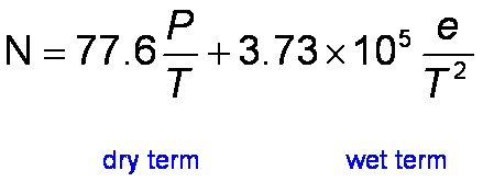
N is typically 310 at sea level in the UK. The value of N can be calculated from this formula:

2d49e0fbd9d0e5b33e1dce4ab9117300.gif


Where:

P = dry pressure, ~1000mb
T = temperature, ~300k
e = water vapour partial pressure ~40mb
The dry term depends only on pressure and temperature, the wet term also depends on the water vapour concentration. The temperature, pressure and water vapour pressure vary with time and space.
Which seems to imply that the refractive index is in part proportional to the water vapor partial pressure. I'm confused!

to me the the laser beam was bent upwards at a certain point tells that it must have been a definite layer or difference where this happened exactly. That is why I suggest the water wapour difference as it is more likely than a higher temperature difference. In case of temperature difference I would expect a continuous bend upwards, not like the one we experienced:

upload_2016-8-21_4-32-56.png
upload_2016-8-21_4-33-50.png
 
Mick I criticised the laser beam leveling in the Hawking experiment - well I still do as they showed no measurements, but I see they faced the same problem but maybe did not recognise it - the refraction of the laser beam.

look at our beam from the boat perspective over that distance that the beam is bent upwards:

20160816_050950.jpg


at the same time from position A at the laser it looks like this:

DSCN1877.JPG


but from a side view it looks like this:


DSCN1899.JPG
 
https://www.metabunk.org/curve/?d=6&h=1.7&r=6371&u=m

Um... At 6km, 1.7m camera height gives me only 0.15m hidden height -- well below your 1.25m high laser so that doesn't seem to show anything at all.

Hey DarkStar you forgot what we discussed as slope corrected leveling of the laser beam :)

As Mick sad that the laser drop calculation is the most exact as measuring the drop of the water surface and adding the laser height - that is my examle too.

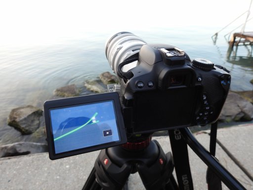
the Canon 650d was at 1 meter height this time but I can't upload the RAW files here, so maybe Mick will convert some of the most interesting.
 
Hmm, I got my assumption from:
http://www.mike-willis.com/Tutorial/PF6.htm
External Quote:
N - Units

The refractive index of air is very close to 1. Typically the refractive index n = 1.0003 at sea level and this is most tedious - there are lots of decimals that must be used because the fine detail is important, so we define a new unit, the "N" unit where:

N = (n - 1) x 1 000 000

N is typically 310 at sea level in the UK. The value of N can be calculated from this formula:

2d49e0fbd9d0e5b33e1dce4ab9117300.gif


Where:

P = dry pressure, ~1000mb
T = temperature, ~300k
e = water vapour partial pressure ~40mb
The dry term depends only on pressure and temperature, the wet term also depends on the water vapour concentration. The temperature, pressure and water vapour pressure vary with time and space.
Which seems to imply that the refractive index is in part proportional to the water vapor partial pressure. I'm confused!

http://www.kayelaby.npl.co.uk/general_physics/2_5/2_5_7.html

Lists water vapor with a lower refractive index than air. Since refractive indices are calculated from partial pressures, the higher the PP of water vapor, the lower the PP of air, and the lower the overall refractive index.

The difference in refractive indices of water and air is about ten N Units, and at 20C the vapor pressure of water is 2.3388 mb. So at 20C and saturation water vapor has an approximate effect on the index of refraction of -0.2N Units (versus dry air), while a 5C increase in temperature (from 15C ambient to 20C water surface temperature) has an effect of about -6 N Units.
 
I would like to hear your opinion on these pictures:

the time is 5:05AM on the 16th

we can detect the laser beam on the hand held upwards (max 2 meter) and the laser beam direct hit into the camera

20160816_050534.jpg


this is the side view at 5:00

upload_2016-8-21_4-52-27.png


at 5:04 :

upload_2016-8-21_5-0-24.png


and at 5:05AM

upload_2016-8-21_5-1-20.png


so the direct hit is clearly visible and measurable at this distance in the boat that proves there is no curvature - right?

plus we can see on the picture that the beam is bent upwards in front of the boat therefore the laser beam sudden rise is not due to curvature drop.

Mick pls calculate this GPS position distance to position A and the supposed curvature drop + laser height calculation to evaluate the results.
 

Attachments

  • DSCN2022.JPG
    DSCN2022.JPG
    179.6 KB · Views: 514
Last edited:
to me the the laser beam was bent upwards at a certain point tells that it must have been a definite layer or difference where this happened exactly. That is why I suggest the water wapour difference as it is more likely than a higher temperature difference. In case of temperature difference I would expect a continuous bend upwards, not like the one we experienced:

View attachment 20758View attachment 20759

There will be a fairly steep thermal gradient near the water's surface, since it's temperature is 5C warmer than overnight lows. This is a far more likely scenario than humidity being the driving factor. Such a layer would be extremely shallow, effectively limited to where there is thermal contact between the water and air.
 
Hey DarkStar you forgot what we discussed as slope corrected leveling of the laser beam :)

As Mick sad that the laser drop calculation is the most exact as measuring the drop of the water surface and adding the laser height - that is my examle too.

the Canon 650d was at 1 meter height this time but I can't upload the RAW files here, so maybe Mick will convert some of the most interesting.

Didn't forget - but you pointed the laser downwards when you measured it's height at some distance to 'level it' - so that isn't valid because you don't start with a truly leveled laser. We covered this also :) At 6km just 0.027 degrees off will erase your 2.83m drop.

When you look back from the boat at some distance and see the laser you are using hidden amount.

You said 1.7 meters before but even at 1m camera, the height hidden is still only 0.46m so you could still easily see the laser when looking back from that position.

We will need to see the full details with multiple height measurements of the laser spot in between, but as shown so far this is not conclusive.

And 6km distance in a bobbing boat simply isn't going to give you enough measurement accuracy to measure the curvature using the method Mick suggested with multiple measurements but at least a consistent downward trend would tell you either refraction or laser angle is to blame. A nearly straight-line will suggest refraction is to blame. And I know that may not sound fair but you were strongly warned against putting the laser down low.

Unless you can overcome that then nothing is proven.

I look forward to more detailed data.
 
Lists water vapor with a lower refractive index than air. Since refractive indices are calculated from partial pressures, the higher the PP of water vapor, the lower the PP of air, and the lower the overall refractive index.
Aha, so "dry pressure" in the equation is the partial pressure of none-water gases in air?
 
Aha, so "dry pressure" in the equation is the partial pressure of none-water gases in air?

Yes.

Edit: Strictly speaking you need to calculate partial pressure for each component of air (N2, O2, Ar, CO2, etc.) and sum them. In practice it looks like only water vapor and CO2 vary enough to require seperate terms.
 
I would like to hear your opinion on these pictures:

the time is 5:05AM on the 16th

We posted about this above but to repeat here:

Looks like the beam hits the inferior mirage towards the far shore, causing the bend up.

The existence of the mirage is strongly suggested by the cut off in lower laser reflection, the other lights on the far shore, and the conditions at that time (warmer water, more humid near water surface, and cooler air above that).

Do you have measurements of the height of the beam all the way across for this case or not? That is the data we need to see.

A repeated series of height observations was what was discussed - correct?
 
Hmm, I got my assumption from:
http://www.mike-willis.com/Tutorial/PF6.htm
External Quote:
N - Units

The refractive index of air is very close to 1. Typically the refractive index n = 1.0003 at sea level and this is most tedious - there are lots of decimals that must be used because the fine detail is important, so we define a new unit, the "N" unit where:

N = (n - 1) x 1 000 000

N is typically 310 at sea level in the UK. The value of N can be calculated from this formula:

2d49e0fbd9d0e5b33e1dce4ab9117300.gif


Where:

P = dry pressure, ~1000mb
T = temperature, ~300k
e = water vapour partial pressure ~40mb
The dry term depends only on pressure and temperature, the wet term also depends on the water vapour concentration. The temperature, pressure and water vapour pressure vary with time and space.
Which seems to imply that the refractive index is in part proportional to the water vapor partial pressure. I'm confused!

It is proportional. Moist air is only less dense than dry air at the same temperature and pressure. Outside of that, a comparison of the densities can't be made.

If pressure increases, density increases (Boyle's Law), hence P (partial pressure of dry gases) and e (partial pressure of water vapor) increasing the refractive index. If temperature increases, density decreases (Charle's Law) and hence why P & e are over T. If temperature increases, pressure increases. Note, pressure also increases with temperature (Gay-Lussac's law). Putting those together gives you P ~ p * T (where p is density); Or P/T ~ p.

The square of T comes from some theory I don't know anything about. (See: page 13 of https://www.jlab.org/ir/MITSeries/V13.PDF).

This provides an explanation of the equation you posted: http://nvlpubs.nist.gov/nistpubs/jres/50/jresv50n1p39_A1b.pdf
 
Yes.

Edit: Strictly speaking you need to calculate partial pressure for each component of air (N2, O2, Ar, CO2, etc.) and sum them. In practice it looks like only water vapor and CO2 vary enough to require seperate terms.
Why is the "wet term" over T^2, but the "dry term" over T?

EDIT: noting explanation/links above.
 
Last edited:
After looking into this more, it appears that for visible light spectrum the K2 and K3 terms in the equation below are lumped as one due to negligible error; which results in the equations listed above. The K2 term is akin to the K1 term for ideal gases -- so no need to explain it. The K3 term is added to account for phase delays in EM wave propagation that result from the permanent dipole moment (which induces an electric field).

upload_2016-8-21_1-30-22.png


to me the the laser beam was bent upwards at a certain point tells that it must have been a definite layer or difference where this happened exactly. That is why I suggest the water wapour difference as it is more likely than a higher temperature difference. In case of temperature difference I would expect a continuous bend upwards, not like the one we experienced

There's no reason to assume it was a water vapor difference instead of temperature difference. In reality, it is a going to be combination of both. It's also impossible to calculate the refractory index (and thus compensate for refraction) without knowing the water pressure and temperatures (or relative humidity + temperature to calculate the water pressure).

Also, because differences in refraction can occur at any point along the lasers path (and thus change the boundary conditions), it would be difficult to accurately compensate using discrete data points (for temp and pressure) along the path. It would require at the very least curve fitting.

So, I don't see how this could have been done as claimed.
 
Last edited:
I think I can explain it. You have to look at a lot of videos and a lot of comments to understand what it is that flat earth believers are thinking. In this case the common belief seems to be that atmospheric refraction is caused by humidity in the air... or water droplets in the air... or just water in the air.

The reasoning seems to go something like this:

Water in a glass bends light: therefore water in the air bends light.

(I've seen no evidence that there is an understanding of why water in a glass bends light. I think it would be something like: "It's in the nature of water to bend light." So the belief that water in the air bends light is just an extension. The water in the air bends light, because it's in the nature of water to bend light.)

This is strengthened by globe earthers telling them and warning them about refraction just above the surface of a body of water.

Sandor seems to be saying that when the lake surface is warmer than the air above it there will be more evaporation and thus a layer of humid air just above the surface. And this humidity will cause more refraction.

Some FE's seem to believe that the warning against refraction just above the surface of a body of water is a warning that water will somehow bend light toward or away from it... just by its very proximity. As if water were creating a force that bends light. Something like magnets and electrons I guess.


Water vapour is a major factor in bending radio waves, causing ducting, for instance, due to sharp refractive index gradients. I don't know to what extent this applies to visible wavelengths.

I don't think I fully explained. In this FE model refractive index and angle of incidence play no role in atmospheric refraction effects. It is simply the presence of water in the air that causes refraction at any point of the sky, even the zenith. And there is no consistent law or model. Just whatever is convenient at the moment.

In this thread... https://www.metabunk.org/atmospheri...-the-eratosthenes-triangulation-method.t7801/

....Sandor at least mentioned density, which puts him ahead of most, but seems unaware of the nature of refraction and the importance of angle of incidence.
 
Last edited:
Sorry for all to keep you waiting!

We came back only Wednesday evening and I started to go over 150GB of video, audio and pictures and organise them.

I sent a lot over to Mick as well to start his evaluation process and he can confirm that it is a huge and very interesting material. So we shall go over a few questions raised in this experiment outcome - on refraction.

We made a conclusive measurement after sunrise with a different laser setup: 1.25 meters high that is 4.1 feet above water level. We have measurement data and evaluating the distances by the GPS coordinates.

The laser was visible and made a direct hit into the camera over a distance of 6 kms that means that the drop + laser height would have been over 4 meters that is NOT possible to film from the rubber boat. Actually the camera eyeheight was about 1.7 meters.

Mick pls share the photos you have evaluated on this distance of the last measurement.

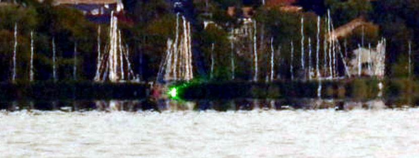
the videos show the laser beam direct hit much better View attachment 20753 View attachment 20754 View attachment 20755 View attachment 20756 View attachment 20757

You haven't labeled these photos so I'm not sure what we're looking at. I'm assuming this a view back to the marina (dock) on which the laser is mounted?

In any case these photos show something important.


020245af908ea7dc6e0de785dbd4bbc4.png

Notice that there is a strange effect above the water. And notice that the laser is within a band of of distortion. The laser is not a sharp point of light. It's a vertical stripe that seems to have separate layers. It even appears to have two beams splitting off from the top and bottom.


bad98fd59a71154e81c11bb4de8fbba4.png

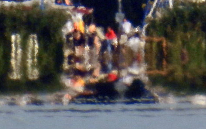
This second photo is even better. This is a complex mirage with many layers; some right side up and some inverted. I think I can count 5 layers.

This seems to me to be a 5-image mirage; or perhaps a fata morgana. If this is the case, and as you can see from this page on Dr. Andrew Young's site; the atmosphere is acting like a series of lenses and the camera is within, or is below strong inversions.

http://aty.sdsu.edu/explain/atmos_refr/phenomena.html


Sandor: Can you explain in your own words what is causing this atmospheric refraction effect?
 
Last edited:
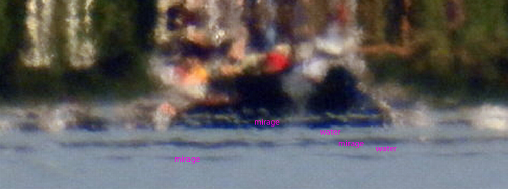
It's an inferior mirage (total internal reflection off the warmed air over the lake), but I think you're right about the true surface level.

Can we see some pictures of the laser hitting the boat? The divergence at distance means just seeing the beam in the camera does not ensure you are anywhere near its center.
 
This seems to me to be a 5-image mirage; or perhaps a fata morgana. If this is the case, and as you can see from this page on Dr. Andrew Young's site; the atmosphere is acting like a series of lenses and the camera is within, or is below strong inversions.

Above the red line is the actual image and below is the reflection off the water. Is that what we are looking at?

It's not a fata morgana or a reflection off the water. It's an inferior mirage. The visible light is being bent up and reflected by the warm air near the surface of the water, just like the laser beam is.

From this distance (6km) and camera height (1.7m) you would be able to see the dock. The mirage is obscuring it.
 
Mick pls share the photos you have evaluated on this distance of the last measurement.
This photo:
20160816_065525-jpg.20753

Is at 6km. And with a camera height of 1.7m, the laser is easily visible.
https://www.metabunk.org/curve/?d=6&h=1.7&r=6371&u=m
External Quote:

Distance = 6 km (6000 m), View Height = 1.7 meters Radius = 6371 km (6371000 m)
Horizon = 4.65 km (4654.18 m)
Bulge = 0.71 meters
Drop = 2.83 meters
Hidden= 0.14 meters

The drop is 2.83m, but that's only relevant if the laser is actually perfectly level. That's why you need multiple measurements all along the line.

And as noted there's no indication of where the center of the laser beam is.

I don't seem to have the dscn2060 and 2084 photo, but then the DSCN photos don't have gps.
 
@Sandor Szekely , there's a lot of different photos. Is there a particular set of photos that shows a series of measurements or observations leading up to the "1.7m camera height" photo?
 
Last edited:
I'm going to approach this very naively, to try to quantify the contribution of humidity and temperature
External Quote:

2d49e0fbd9d0e5b33e1dce4ab9117300.gif


Where:

P = dry pressure, ~1000mb
T = temperature, ~300k [27C]
e = water vapour partial pressure ~40mb
Now for a start, that's from a page on radio wave propagation, so there might be problems right there, but continuing.

What's the magnitude of the effects over the few feet directly above the lake surface? Lake was at 22°C (295K) Air was at 14C (287K), pressure is about 1000, and I'm assuming that varies very little

Water vapor partial pressure, let say for now it varies from 100%RH at the surface of the lake to 50% RH above it.
RH = Actual Vapor Pressure/Saturation Vapor Pressure as a %

Using this calculator:
http://www.srh.noaa.gov/epz/?n=wxcalc_vaporpressure
Saturation Vapor Pressure at 22C (water level) is 26.5mb
Saturation Vapor Pressure at 14C (few feet up) is 16mb, 50% of that is 8mb

So taking those two extremes, at water level:
N = 77.6*1000/295+3.73*10^5*26.5/295^2
N = 263 + 113.6 = 376.6

In the air, varying humidity and temperature
N=77.6*1000/287+3.73*10^5*8/287^2
N = 270.3 + 36.2= 306.5 (decrease in N as we rise, so bend down)

If we just vary humidity:
N=77.6*1000/295+3.73*10^5*8/295^2
N = 263 + 34.3 = 297.3 (bigger decrease in N as we rise, so bend down)

If we just vary temperature:
N =77.6*1000/287+3.73*10^5*26.5/287^2
N =270.4 + 120.0 = 390.4 (increase in N as we rise, so bend up).

I'm assuming the first P term has the water vapor partial pressure factored in, and is not actually the dry pressure.

Of course, we can't just vary humidity, so the actual meaning of these numbers (if any) is rather dubious. For a start, if the air humidity is 50%, then will it actually be 100% just above the lake surface?

Interesting stuff, but probably ultimately irrelevant to the outcome of the experiment.

However, the laser does bend up, which would seem to suggest the humidity was not a factor, unless I've got something backwards.
 
It's not a fata morgana or a reflection off the water. It's an inferior mirage. The visible light is being bent up and reflected by the warm air near the surface of the water, just like the laser beam is.

From this distance (6km) and camera height (1.7m) you would be able to see the dock. The mirage is obscuring it.

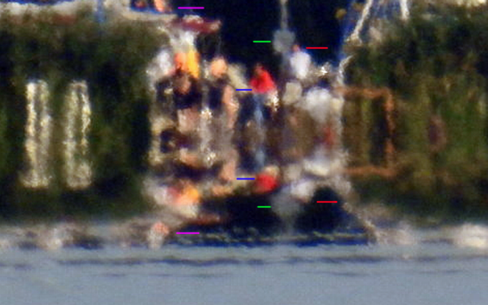
Looking at it again, I've changed my mind. Yes, it's an inferior mirage. I think we're seeing people standing on a dock at a marina.

3e8716e03e20fe266cfc0bd6c23e90ff.png

These colored lines label the original and the inverted image. The blue lines label a man in a red shirt and his inverted image; the red lines label a man in a white shirt and his inverted image, and so on. These inverted images are not reflections in the water.

It's tempting to see this as a boat with an outboard motor (green line); but that "outboard motor" is just an inverted image of a white sign or something similar.


However, there are discontinuities in the inferior mirage. Not different layers, simply discontinuities.
11d2bf77791787da0cb59ca1fc2b77e6.png


I've labeled the most obvious ones here, but I think there are other discontinuities. These are not different mirages or even different layers. It's all one inferior mirage; but here and there the light rays are not being refracted and you can see the "real" image.
 
Last edited:
I'm going to approach this very naively, to try to quantify the contribution of humidity and temperature
External Quote:

2d49e0fbd9d0e5b33e1dce4ab9117300.gif


Where:

P = dry pressure, ~1000mb
T = temperature, ~300k [27C]
e = water vapour partial pressure ~40mb
Now for a start, that's from a page on radio wave propagation, so there might be problems right there, but continuing.

What's the magnitude of the effects over the few feet directly above the lake surface? Lake was at 22°C (295K) Air was at 14C (287K), pressure is about 1000, and I'm assuming that varies very little

Water vapor partial pressure, let say for now it varies from 100%RH at the surface of the lake to 50% RH above it.
RH = Actual Vapor Pressure/Saturation Vapor Pressure as a %

Using this calculator:
http://www.srh.noaa.gov/epz/?n=wxcalc_vaporpressure
Saturation Vapor Pressure at 22C (water level) is 26.5mb
Saturation Vapor Pressure at 14C (few feet up) is 16mb, 50% of that is 8mb

So taking those two extremes, at water level:
N = 77.6*1000/295+3.73*10^5*26.5/295^2
N = 263 + 113.6 = 376.6

In the air, varying humidity and temperature
N=77.6*1000/287+3.73*10^5*8/287^2
N = 270.3 + 36.2= 306.5 (decrease in N as we rise, so bend down)

If we just vary humidity:
N=77.6*1000/295+3.73*10^5*8/295^2
N = 263 + 34.3 = 297.3 (bigger decrease in N as we rise, so bend down)

If we just vary temperature:
N =77.6*1000/287+3.73*10^5*26.5/287^2
N =270.4 + 120.0 = 390.4 (increase in N as we rise, so bend up).

I'm assuming the first P term has the water vapor partial pressure factored in, and is not actually the dry pressure.

Of course, we can't just vary humidity, so the actual meaning of these numbers (if any) is rather dubious. For a start, if the air humidity is 50%, then will it actually be 100% just above the lake surface?

Interesting stuff, but probably ultimately irrelevant to the outcome of the experiment.

However, the laser does bend up, which would seem to suggest the humidity was not a factor, unless I've got something backwards.

I like this logic, but we can not exclude the possibility of humidity change over the lake surface.
The water is very shallow like 1 meters on the south side of the lake for kms from the shore. that could possibly evaporate differently as cooling down more over night than in the deeper waters of the northern shore. the laser never touched the water surface, but the humidity could be significantly different in the 2 sides of the lake

the laser was actually a bit upwards to perfect level at the leveling distance
20160816_064032.jpg
 
But I'm still bothered by this one.
020245af908ea7dc6e0de785dbd4bbc4.png

It can be interpreted as the laser and an inferior mirage of the laser, thus a double image of the laser. Okay. But why to our left is the band across the photo completely dark? Why is there a separation between the boat masts and the inverted images of the boat masts? And it's strange to our right too. Is this dark band across the photo a combination of an inferior mirage PLUS a camera artifact from the bright laser?

Or is there a breakwater between us and the boats? And the laser is set up on the breakwater?
 
Looking at it again, I've changed my mind. Yes, it's an inferior mirage. I think we're seeing people standing on a dock at a marina.

3e8716e03e20fe266cfc0bd6c23e90ff.png

These colored lines label the original and the inverted image. The blue lines label a man in a red shirt and his inverted image; the blue lines label a man in a white shirt and his inverted image, and so on. These inverted images are not reflections in the water.

It's tempting to see this as a boat with an outboard motor (green line); but that "outboard motor" is just an inverted image of a white sign or something similar.

However, there are discontinuities in the inferior mirage. Not different layers, simply discontinuities.

I've labeled the most obvious ones here, but I think there are other discontinuities. These are not different mirages or even different layers. It's all one inferior mirage; but here and there the light rays are not being reflected and you can see the "real" image.


haha I am in the red pullover :)

you are right the refraction line is not straight, indeed ever changing by time as seen in the videos

here is a picture of the setup from the boat view:
DSCN2047.JPG
 
I'm going to approach this very naively, to try to quantify the contribution of humidity and temperature
External Quote:

2d49e0fbd9d0e5b33e1dce4ab9117300.gif


Where:

P = dry pressure, ~1000mb
T = temperature, ~300k [27C]
e = water vapour partial pressure ~40mb
Now for a start, that's from a page on radio wave propagation, so there might be problems right there, but continuing.

What's the magnitude of the effects over the few feet directly above the lake surface? Lake was at 22°C (295K) Air was at 14C (287K), pressure is about 1000, and I'm assuming that varies very little

Water vapor partial pressure, let say for now it varies from 100%RH at the surface of the lake to 50% RH above it.
RH = Actual Vapor Pressure/Saturation Vapor Pressure as a %

Using this calculator:
http://www.srh.noaa.gov/epz/?n=wxcalc_vaporpressure
Saturation Vapor Pressure at 22C (water level) is 26.5mb
Saturation Vapor Pressure at 14C (few feet up) is 16mb, 50% of that is 8mb

So taking those two extremes, at water level:
N = 77.6*1000/295+3.73*10^5*26.5/295^2
N = 263 + 113.6 = 376.6

In the air, varying humidity and temperature
N=77.6*1000/287+3.73*10^5*8/287^2
N = 270.3 + 36.2= 306.5 (decrease in N as we rise, so bend down)

If we just vary humidity:
N=77.6*1000/295+3.73*10^5*8/295^2
N = 263 + 34.3 = 297.3 (bigger decrease in N as we rise, so bend down)

If we just vary temperature:
N =77.6*1000/287+3.73*10^5*26.5/287^2
N =270.4 + 120.0 = 390.4 (increase in N as we rise, so bend up).

I'm assuming the first P term has the water vapor partial pressure factored in, and is not actually the dry pressure.

Of course, we can't just vary humidity, so the actual meaning of these numbers (if any) is rather dubious. For a start, if the air humidity is 50%, then will it actually be 100% just above the lake surface?

Interesting stuff, but probably ultimately irrelevant to the outcome of the experiment.

However, the laser does bend up, which would seem to suggest the humidity was not a factor, unless I've got something backwards.
http://www.kayelaby.npl.co.uk/general_physics/2_5/2_5_7.html

"This water vapour term is dependent upon wavelength. In the visible region (405–644 nm") the relationship is
a23897a3e206df7b1130ec0f08f99e2b.gif


ntp fntp = −f (3.7345 − 0.0401σ2) × 10−10,


where ntp f is the refractive index of air containing water vapour at a partial pressure of f Pa, the total pressure still being p. This equation is valid only for conditions not deviating very much from normal laboratory conditions (t = 20 °C, p = 100 000 Pa, f = 1500 Pa)"
 
Last edited:
But I'm still bothered by this one.
020245af908ea7dc6e0de785dbd4bbc4.png

It can be interpreted as the laser and an inferior mirage of the laser, thus a double image of the laser. Okay. But why to our left is the band across the photo completely dark? Why is there a separation between the boat masts and the inverted images of the boat masts? And it's strange to our right too. Is this dark band across the photo a combination of an inferior mirage PLUS a camera artifact from the bright laser?

Or is there a breakwater between us and the boats? And the laser is set up on the breakwater?


That dark band is the vegetation as you see in my picture above.
the refraction was changing and the laser beam was moving as seen on the videos

this is an interesting picture on the inferior mirage :

laser refraction.png
 
I like this logic, but we can not exclude the possibility of humidity change over the lake surface.
The water is very shallow like 1 meters on the south side of the lake for kms from the shore. that could possibly evaporate differently as cooling down more over night than in the deeper waters of the northern shore. the laser never touched the water surface, but the humidity could be significantly different in the 2 sides of the lake
I would like to hear your opinion on these pictures:

the time is 5:05AM on the 16th

we can detect the laser beam on the hand held upwards (max 2 meter) and the laser beam direct hit into the camera

View attachment 20765


this is the side view at 5:00

View attachment 20764

at 5:04 :

View attachment 20766

and at 5:05AM

View attachment 20767


so the direct hit is clearly visible and measurable at this distance in the boat that proves there is no curvature - right?

plus we can see on the picture that the beam is bent upwards in front of the boat therefore the laser beam sudden rise is not due to curvature drop.

Mick pls calculate this GPS position distance to position A and the supposed curvature drop + laser height calculation to evaluate the results.

The distance from the laser to the raised hand pic is 1.6 miles, the drop at that point would be about 20" or 0.5m. That individual observation proves nothing. We don't know what angle the laser is originally at, or exactly how much it is bent up by the mirage.

Unless you've got a series of height readings, then you can't conclude anything - and even then with the various refraction effects it's quite difficult
 
To calculate a distance between two points there are various online calculators, but I think the best way is to use Google Earth, as it's very visual, and you can confirm the points look like they are where they are supposed to be:

I'd use a folder, then right click on it, and "Add- > Placemark"
20160821-150322-yz2ah.jpg


Then enter a name and the coords of the photo
20160821-150453-hyexv.jpg


Repeat for the second position, and then use the measuring tool
20160821-150546-ee0sg.jpg
 
Sandor told me that they had measured the laser at 1.6 meters at 5.6 miles and I mistakenly assumed that the photo I posted was in reference to that claim. I have no reason to disbelieve Sandor

@Sandor Szekely, can you clear that up? I don't see any photos that have GPS more than the 1.6 miles of the "Raised Hand" photo:
20160821-162021-o6ctu.jpg

So what's this about 5.6 mile? Am I missing something?
 
If in Google Earth you make a path across the surface of the lake, then zoom in on it, you see the curve of the surface of the lake (green line).

20160821-164531-6bdez.jpg


Now it's very hard to see, but it almost looks like the reflection of the laser is starting to take this curve:
20160821-165008-wtb0a.jpg
 
Status
Not open for further replies.
Back
Top