How far away is that contrail? Streamwood, IL 2nd March 2015

TEEJ

Senior Member.
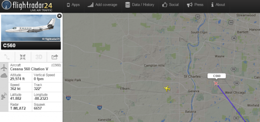
Classic case of an individual not being able to determine just how far away the aircraft and contrail is.

He claims that the aircraft is "directly overhead" and attempts to find it on Plane Finder.


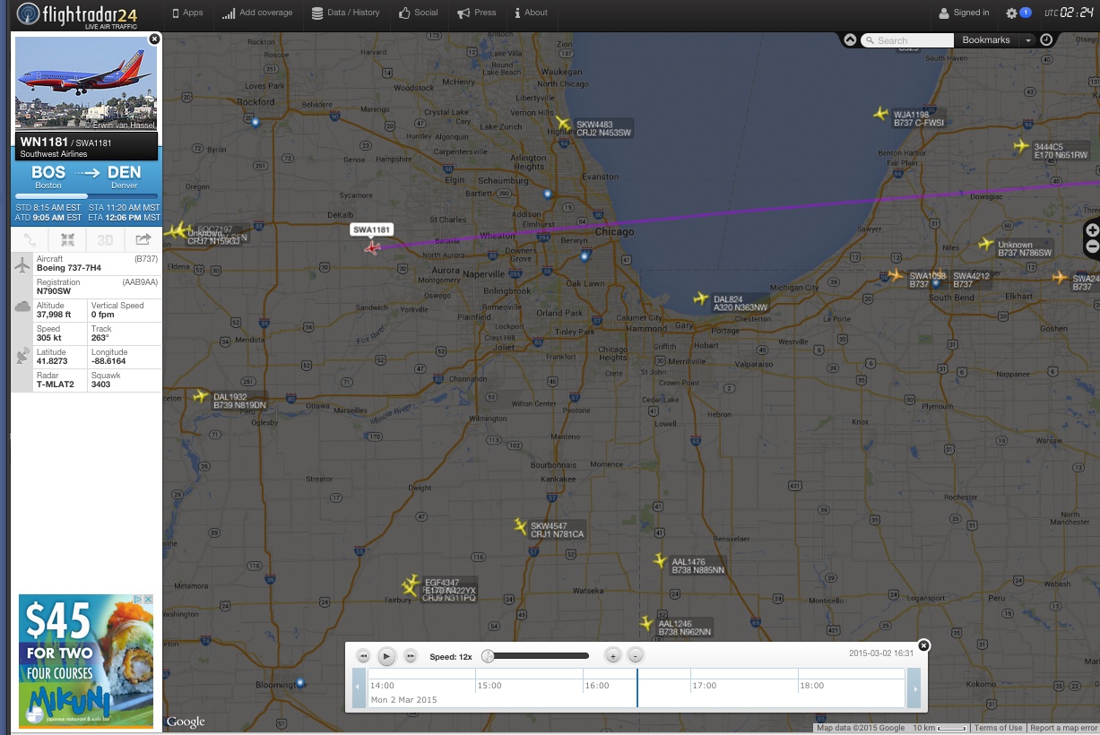
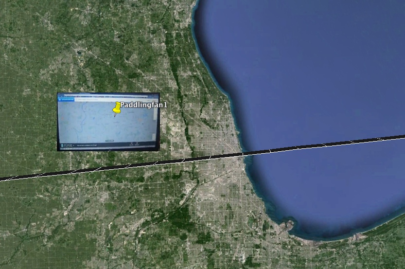
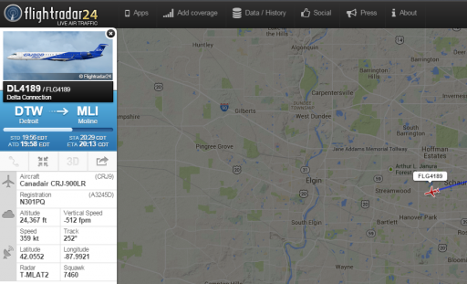
He notices on Plane Finder an aircraft heading for his location and steps out to film it. He believes that he is filming the Airbus A320 UA549 UAL549 N428UA that appears with the picture on the left of the Plane Finder screen.

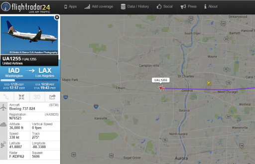
The video is slightly blurred but the airliner actually selected on the moving track is Flight Number 5925. That is United Express Embraer ERJ-145LR registration N16963. UAL549 Airbus A320 came nowhere near Streamwood and landed at Chicago O'Hare from over the lake. It didn't fly west of O'Hare.

http://www.flightradar24.com/2015-03-02/16:29/12x//5a7a565

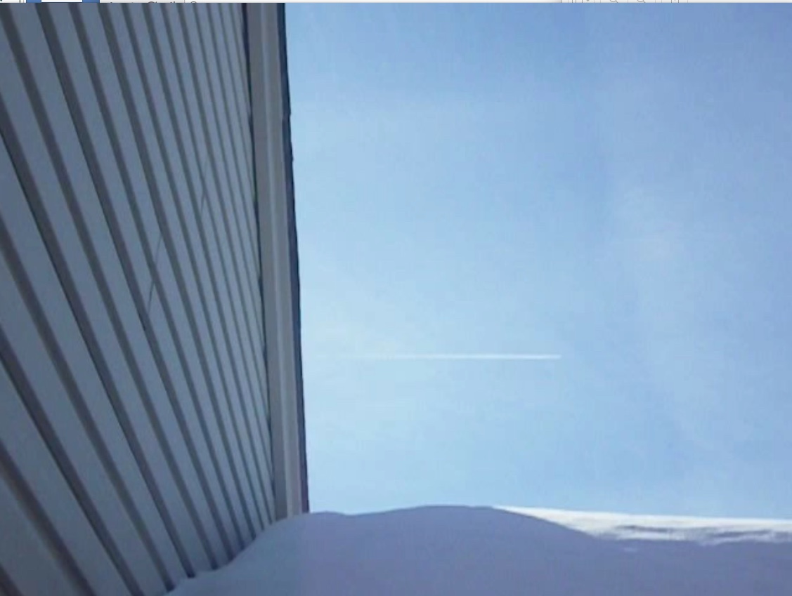
The initial aircraft that he films is obviously at considerable distance.
 
Looks like he's looking due south, and the plane is flying from east to west. Based on the house (looks like he's filiming from his back yard, over the garage.


10:36AM Illinois time (CST) is UTC-6, so 4:36PM (16:36) UTC, March 2nd.

I'd vote for: SWA1181, 38,000 feet
 
Looks like he's looking due south, and the plane is flying from east to west. Based on the house (looks like he's filiming from his back yard, over the garage.


10:36AM Illinois time (CST) is UTC-6, so 4:36PM (16:36) UTC, March 2nd.

I'd vote for: SWA1181, 38,000 feet

That was the one I had picked out a little more than an hour before you were looking at it. I was hoping Paddingfan would have given me the direction he was looking.

paddigfarflightradara.jpg

About the time he went back outside, UA 605 would have appeared to be just about overhead.

paddingfarflightradr2b.jpg
 
Thanks for the analysis, guys!

It shows clearly where he went wrong when looking at the Plane Finder map. He was convinced that the aircraft was
overhead and didn't extend the map far enough. The area at the bottom is just south of Wayne. If he hadn't been fooled by distance then he would have seen on Plane Finder the Boeing 737 much further south.

upload_2015-3-5_11-53-35.png


upload_2015-3-5_11-55-3.png
 
The OP video has been taken at #### ‎, Streamwood, IL 60107, USA

This is how the SWA1181 flight track looks from the author's backyard on Goggle Earth:
SWA1181 IL.jpg
Unfortunately, there are no 3D buildings for that area, but the elevation of contrail above the horizon is about right.
Note that the time of SWA1181 being in the filmed position (4:29 PM UTC) is a few minutes earlier than stated in the OP video title.
 
Last edited:
The OP video has been taken at #### Streamwood, IL 60107, USA

I've removed the full address and photo of house, as I don't think it's appropriate to be publishing people's addresses if they don't publish it themselves. Even if it can be determined in a few minutes of googling, based on his YouTube channel and user name.

I think it's sufficient to say that the view is due south from Streamwood.
 
Here's the area he was looking at in Planefinder, and the track of the most likely actual plane, SWA1181
 
I've removed the full address and photo of house, as I don't think it's appropriate to be publishing people's addresses if they don't publish it themselves. Even if it can be determined in a few minutes of googling, based on his YouTube channel and user name.

I think it's sufficient to say that the view is due south from Streamwood.

Well, I did not google him. I've noted the house number on his garage and looked for the same facade on Google Maps in the StreetView thumb on the left. Does his showing the facade of his house on the video constitute the publishing his own address?
Anyway, I only wanted to check how would the SWA1181 flight track look from the exact location on Google Earth and to update my previous post with this info (done).
 
This is how the SWA1181 flight track looks from the author's backyard on Goggle Earth:
…there are no 3D buildings for that area, but the elevation of contrail above the horizon is about right.
Note that the time of SWA1181 being in the filmed position (4:29 PM UTC) is a few minutes earlier than stated in the OP video title.

I'd like to revise the above statement. It appears that the SWA1181 flight track is much higher in the sky than the filmed contrail. From the images on Google Earth and StreetView, the estimate of the garage height is about 4 meters and the angle of its roof slope is about 20°. The elevation of contrail in the video is closer to the latter than to the elevation of the SWA1181 flight track (~35°). There was another candidate flight, WJA1198, passing farther south and later on:
View attachment 11767
the track of which fits the contrail position better when viewed from the same location:
View attachment 11768
The front oblong represents the garage back wall, the top edge of the other corresponds to the top of the roof. The WJA1198 would have come into the view at 4:47 PM UTC (10:47 local time).
 
Yet again my picture attachments have disappeared, this time from my previous post. Perhaps, it is for the better, as my detailed analysis of the OP video reinstates SWA1181 as the most likely candidate, confirms the time of the video being around 10:30 AM local time (CST) = 4:30 PM UTC and identifies the second plane as UAL775 (ORD -> JAC).

I've downloaded the video on my computer to extract relevant frames. The time of the video is confirmed by the Sun position and direction of shadows, which can be seen in the second half of the video, when its author comes out through the front door. The shadows heading is about 153° that corresponds to 10:30 AM of local time.
Screen shot 2015-03-09 at 23.43.59.png
The Sun elevation at the time was 36°. It gives more accurate estimate of the contrail elevation in the beginning of the video. Although the Sun was behind the taller part of house on the left, there was a convenient mark in the sky: an aged "vertical" contrail with a twist. The contrail in question passed right across the twisted area:
Screen shot 2015-03-09 at 23.02.07.png
This area can be seen from the front of the house one and half minutes later. Westerly wind brought it closer to the Sun position but had little effect on its elevation, which was slightly lower than the Sun in the upper left corner of the following frame:
Screen shot 2015-03-09 at 23.08.43.png
That is, elevation of the contrail in the beginning of the OP video was about 35°, the same as the elevation of the SWA1181 flight track. Interestingly, this contrail did not persist as it left no white line across the twisted area of the "vertical" contrail (note that the contrails crossing it below the twisted area could not be seen in the beginning of the video, obscured by the garage). Moreover, the plane appeared to stop leaving trail altogether. It would still be in that part of the sky that was scanned by the camera in less than two minutes since the author filmed the contrail from his back yard. However, no trail can be seen after he reemerged in the front of the house to look for the second plane.

The second plane was flying almost overhead, yet to the north of the house. This location and the time interval between the two planes identify UAL775 as the most likely candidate for the second plane:
Screen shot 2015-03-09 at 23.29.05.png
It is further supported by viewing the UAL775 flight track on Google Earth from the approximate camera location.
I do not put a picture of the front of the house here, but instead attach a KMZ file with the two flight tracks and camera location.
 

Attachments

  • Streamwood contrail.kmz
    7.8 KB · Views: 662
Last edited:
Another two from the same guy. In the first video he is claiming that they are directly overhead.


Attachments

  • upload_2015-3-11_20-50-54.png
    upload_2015-3-11_20-50-54.png
    743 KB · Views: 526
  • upload_2015-3-11_20-53-6.png
    upload_2015-3-11_20-53-6.png
    515.7 KB · Views: 487
  • upload_2015-3-11_21-0-47.png
    upload_2015-3-11_21-0-47.png
    675.6 KB · Views: 438
Last edited:
Another two from the same guy. In the first video he is claiming that they are directly overhead. I see them as UA1255 and the Cessna Citation. Approximately 13 and 11 miles distance respectively from Streamwood (Streamwood Top right in the first two screen shots)

Yea, his "directly overhead" would be about 20-25° above the horizon. If his time of the (first) video is correct, the Sun elevation was only about 10°. He had to duck behind the car to cut off the Sun. The elevations of the planes were just about twice the Sun elevation.

I agree with you identification of these two planes. I did not bother with the second video.
 
Last edited:
Another two from the same guy.
I have looked through the second video this morning.

The first thing is it has a wrong time stamp, 6:48 PM (CST), that would be nearly an hour after the sunset at 5:51 PM. The video, however, was taken at about the sunset time:
Screen shot 2015-03-12 at 09.17.42.png
EDIT: As the US have switched to the Day Saving Time on the previous day, March 8th, the time stamp in CDT (UTC -5 hours) is probably correct.

The second thing is that the guy misjudged not only the distance but also the direction to the trail. He went in to look for it at Planefinder, but discarded his first pick, because that plane "went to the north of the house". But the plane was behind the house facing south in the above frame, so it did go to the north of it.

It is not possible to read the info of that plane on blurred video of his Planefinder display, but its path and other details match those of AWE676 (PHL -> LAS) that passed over the area just before the sunset at about 4:45 PM (23:45 UTC):
Screen shot 2015-03-12 at 09.06.13.png

Viewing AWE676 flight track from the camera location on Google Earth supports this identification:
Streamwood AWE676.jpg

The guy, however, ruled out this probably correct finding without any checks in favour of "another unidentified jet, spraying us".
 

Attachments

  • FlightAware_AWE676_KPHL_KLAS_20150309.kml
    59.2 KB · Views: 848
Last edited:
I have looked through the second video this morning.

The first thing is it has a wrong time stamp, 6:48 PM (CST), that would be nearly an hour after the sunset at 5:51 PM. The video, however, was taken at about the sunset time:.

Sunset on Mon, Mar 9 was 6:52 PM

http://sunrise-sunset.org/us/streamwood-il

Update. Have I missed something with the clock change on March 8? Why is it that the pesky clock change always gets in the way? It's a conspiracy! :)

http://www.timeanddate.com/time/change/usa/chicago?year=2015
 
Last edited:
I think that he has the correct time on the video. Sunset on Mon, Mar 9 was 6:52 PM

http://sunrise-sunset.org/us/streamwood-il
I think the time at that link corresponds to UTC -5h, not to the time I used, UTC -6h.
With the sunrise and sunset times being about 7 AM and 7 PM, respectively, the solar noon would be at about 1 PM, as it usually is at the summer time (CDT). Has the summer time already started in the US? I did not count for this.
 
March 8th the change took place. I didn't realize it myself until you brought up the time stamp on the video.
 
March 8th the change took place. I didn't realize it myself until you brought up the time stamp on the video.
If so, the time stamp of the first video probably is also in CDT (UTC -5h). This means that your initial identification of the planes has to be revised. The Sun elevation was about 19°, that is, higher than I suggested in #15, so the planes also were higher and hence closer to the camera. I' think that one of them was UPS2998:
Screen shot 2015-03-12 at 13.06.24.png

PS UPS2998 and UAL1090 are the most likely candidates for the two planes from the first video. Both planes are in the approximately correct positions in the sky relative the Sun when viewed from the camera location on Google Earth:
Streamwood_UAL1090_UPS2998.jpg
(UAL1090 flight track is on the left, and UPS2998 one is on the right).
 

Attachments

  • FlightAware_UAL1090_KIAD_KDEN_20150309.kml
    40.2 KB · Views: 1,049
  • FlightAware_UPS2998_KSDF_PANC_20150309.kml
    50.2 KB · Views: 991
Last edited:
If so, the time stamp of the first video probably is also in CDT (UTC -5h). This means that your initial identification of the planes has to be revised. The Sun elevation was about 19°, that is, higher than I suggested in #15, so the planes also were higher and hence closer to the camera. I' think that one of them was UPS2998:

Thanks. Yes, I agree. I've told him to download the Flight Radar 24 app for his phone/tablet, but it looks like it has fallen on deaf ears. He needs to be more precise and film Planefinder more accurately and with better quality. At least have a clock on the screen!
 
Well form the comments I don't think he is in the slightest bit interested in the truth, just in his so called proof. You can't go round telling him his directly overhead plane is 10 miles away. He doesn't want to admit to being mistaken.
 
Back
Top