Jason
Senior Member
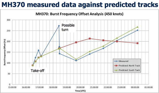
I found an article from a site called Physics Buzz that might help you see things in a different light. http://physicsbuzz.physicscentral.com/2014/03/how-did-inmarsat-really-find-flight.htmlThey did not say the frequency increased though, unless there somewhere is an official report publicized stating that. The graph displays "frequency offset". That ofset could be negative for what we know.
I would also recommend checking out the comments below, because its seems many people have asked questions about how the measured the frequency using the doppler shift. But the one thing I'm not able to accept at this time, is that there would be a multinational cover up to protect Malaysian Airlines' negligence. No one wants to go through this again and considering all of the speculation out there it would be the most easily available and "provable" direction for investigators...External Quote:Tuesday, March 25, 2014
How Inmarsat Hacked Their Data to Find Flight MH370[/paste:font]
The mystery behind the missing Malaysian Airlines flight MH370 is no more. Engineers working out of the British company, Inmarsat, have used a "groundbreaking but traditional mathematics-based process" to conclude that the plane landed in a remote region of the southern Indian Ocean. Plane wreckage has yet to be found to support this notion.
Yesterday afternoon, the Malaysian Prime Minister, Najib Razak, announced in a press statement that the investigation was completed with a never-before-used analysis. However, few news articles are getting their hands dirty with the details of this mystery-solving method.
From most of the articles you'll get a sense that it has something to do with the Doppler effect, trigonometry, a satellite and a magical mathematical equation that ties everything together. But how do these elements coalesce into a single, coherent story?
If you look at a general equation of the Doppler effect, you'll notice that nowhere does it offer information about an object's position in space. But you can still get an idea of an object's location and direction of travel from the Doppler effect.
If you have an object that emits a signal, like a train blowing its horn, the frequency of that signal depends on the speed and direction the object is traveling and also on the speed and direction of the instrument measuring the signal.
Malaysian Airlines lost touch with Flight 370 on March 8. After that, the plane's only form of communication was brief "pings" indicating that the plane was still operational. An Inmarsat satellite detected a handful of these electromagnetic signals, which turned out to be key to solving the mystery.
The frequency of the ripples that the car emits change as the car moves. If you were on the left, you would measure a higher frequency than the original frequency, and if you were on the right you would measure a lower frequency. Credit Charley Whisky.
Velocity, alone, cannot tell you anything about position. But if you have a reference point in space with a known position, you can determine your target object's position with respect to your reference point.
Say the satellite and the plane were both at the same height above the Earth's surface and the plane was flying in a straight line away from the satellite. This simplified version breaks the problem down into one dimension. If you knew the position and velocity of your satellite and you knew the velocity of the plane, you could easily map the plane's position over time.
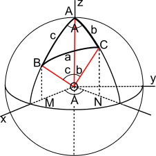
Now consider the more realistic scenario that the satellite is many thousands of kilometers higher than the plane. You can still solve the position problem, but you are now dealing with a solution that requires some trigonometry in a three-dimensional space. And since the satellite is orbiting Earth and the plane is also moving, albeit at a different velocity, this becomes a very complex problem very quickly.
Imagine the satellite sitting at the top of the sphere. Now, picture the plane flying across the surface. Notice the multiple angles and positions you would need to account for while attempting to model the plane's flight path. Credit: Peter Mercator.
I imagine that most of data-crunching marathon the Inmarsat engineers took to determine the plane's crash site to within 100 miles, was spent identifying how best to determine MH370's final destination given the few data points available and testing that series of equations using known flight paths of other Malaysian flights.
The single Inmarsat satellite that detected the plane's pings measured the frequency of only eight pings in total. From that, engineers plotted the plane's likely course across the Indian Ocean using a combination of the Doppler effect to calculate the plane's velocity with respect to the satellite and trigonometry to then map the plane's flight path and ultimately determine where it likely crashed after emptying its fuel tanks.
The ten Inmarsat satellites orbiting Earth were built as part of the Global Maritime Distress and Safety System and have never before been used for this type of mission, said Inmarsat Senior Vice President, Chris McLaughlin.

Last edited:


")