Over the years I have participated in several hundred 'on land' Radio Foxhunts (RDF).
The techniques used are no different to locating an 'audio' signal (Pingers = 37.5 khz UltraSonic Sound)
Here's why I feel the way Ocean Shield's method of locating a source signal sucks & leaves room for improvement.
WAY ONE: Using a low tech quarter-wave whip (The equivalent to an
omni-directional hydrophone - same as TPL-25 has)
I drive 12 Km along a road in a straight line. I constantly make measurement of the source signal's strength.
1. 'IF' I am lucky the signal strength varies in a linear fashion, allowing me to make JUST ONE plot along that line the strength was greatest.
(useful but for only ONE useful 'directional' plot, I need more measurements just like this - to make it fully directional - travel the lines: then join the dots from other lines, intersect is source)
____________________*____________ <-- * represents the point the signal was strongest.
2. But what if I was far away from the source ? The signal strength maybe varies by a little across the whole 12 Km distance. (not as useful)
_____________*************_____
3. By using this method what would happen to my plot, if the source peak volume wasn't constant ?
I would have no way of really knowing this without measuring 'at the source'.
It could really mess things up.
WAY TWO: (now adapting some words for underwater use)
Using a directional hydrophone, or an array of half/full parabolic hydrophones.
4. Ok, this time I travel same 12 Km straight line and make 4 specific 'directional' measurements.
I stop at each '*' turn my single directional hydrophone until I determine direction of greatest strength,
I draw a line on my map in 'that' direction for each line = the intersect point is my source.
(A hydrophone array requires a single 'burst' measurement)
*__________*__________*__________*
How could I apply this to finding a pinger ?
Well there maybe/most likely some 'deep water' intricacies I have no idea about that limit this, but I continue.
EG - Time it takes to get Hydrophones into position - pressure bla, bla (other things I know squat about)
Parabolic Array - 3 or more hydrophones - parabolic microphones are not science fiction & backed up by 'hand-held directional pinger locators' are commercially available, I also assume it would be hard to keep 'my array' perfectly still underwater and that's a good thing and hence the need to be calibrated / direction determined by an underwater electronic compass.
PROs of using 'something' with directional properties.
1. I instantly know which side (North, South ?) of my 12 Km straight line my source is (not the case in 1. or 2.)
2. For travelling 12 Km I have 4 directional plots, lines can be drawn on a map, the intersection point of those lines is our source.
(can be further fine tuned by travelling along another path and making further directional measurements and plotting on same map: IF source signal continues)
3. My second 'straight line' will most definitely be closer to the source (North, South ?)
(not the case in 1. or 2. for a 2nd pass: they in fact may end up further away !)
And no, not a good idea to directly head towards source for a 'second run' you may get signal saturation and that is not helpful.
4. Maybe I can move between the 4 points faster & I am not required to measure the strength constantly 'in between' - which then requires complex algorithms to analyse.
5. Range & Signal Gain: Using a parabolic hydrophone I can hear signals further away, as another benefit I get an improved signal to noise ratio.
6. My readings are not sent to 'hell' if the signal source's power supply is depleting/fluctuating.
(volume output varies)
(1. or 2. depend on 'constant' source power/transmission volume, both along & between 'measurement paths')
I can still get a very good sense of direction even when the 'volume' is varying.
OK so that was a very basic comparison of 2 'Direction Finding' (DF) techniques, there are more.
Now take a look at the "High-Tech - TPL-25", a single omni-directional hydrophone mounted over a 'string-ray' like body.
Clearly the body is designed to swim through the water with minimal drag, useful I guess, if you have NO idea where the source may be.
But then once you actually detect a signal, oh what a pain & waste of time getting any sort of 'directional sense' from a TPL-25 would be.
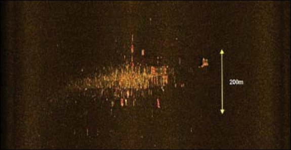
The 'in-boat' 'display' part of 'the system' would be a glorified oscilloscope capable of recording freq., time & strength.
This is the END of what I know and have had 'real life experience with'
Now I need a seaman / fisherman to tell me how long they think it would take to lower/raise a suitability weighted 'device' on cable 4 Km long ?
Answer as quoted from
http://www.jacc.gov.au/media/interviews/2014/april/tr006.aspx
External Quote:
Peter Leavy: .....Ocean Shield...... , it will be approximately two hours to recover her towed pinger equipment. ...........another two to three hours to redeploy the equipment.
Would it be necessary to be raised completely just to move to another suitable measurement location.?
Or maybe could it remain extended at depth ?
I guess the diameter of the reel housing the cable & 'reel guide' (to prevent tangling whatever) would be important to deploy a cable.
I have read 'turning' Ocean Shield with the TPL-25 on tow takes hours, maybe this is with the TPL-25 remaining at full depth.?
I also read in what seems a well written article that "Ocean Shield" is pulling the TPL-25 at a depth of 3 Km on 4.5 Km of cable - 'the max length' - (needs confirmation) if correct - 3Km (while moving) is the max working depth, so, is it deep enough ? Could this explain intermittent reception ?
External Quote:
as above source Peter Leavy: .....As you can appreciate, she has 6000 metres of tow behind her
OK, it seems maybe I am splitting the tools in the 'hunt' - Then maybe how could the existing tool be improved ?
Well for starters, if the TPL-25 had 2 hydrophones, separated by a medium designed to block/filter/limit a signal from it's opposite side, rather than just one hydrophone, that would help LOTS.
Equal signal @Both = source either in-front/behind. (directly below)
Greater signal @left/right = gives you an idea to steer towing ship to 'balance' both, and a general directional plot of source.
Ship keeps moving trying to balance left/right - if it decreases equally at both hydrophones, maybe you are moving away. (increases = towards source.)
Even if you have have the situation of 'decreasing equally at both hydrophones' , keep going, if you
can travel a straight line and keep
balance continue until loss,
then turn round and draw a
straight line path back, it may just take you over the top.
But for sure, 2 Hydrophones would be MUCH better than 1 !
I guess what I am saying is from my point of view, this technology seems to have miles of room for improvement.
This is why I said previously, it feels like a "Wasted Opportunity" of several hours 'constant' signal reception. (total of 4 events)
Now days have ticked by... Where's the plane ? Are they really 'any' closer ?
I guess I had better check JACC's site, been working across week-end and had almost no time to read up on updates.


")