Debunked: Isle of Man from Blackpool at water level proves flat earth [refraction]

MisterB

New Member

Source: https://m.youtube.com/watch?v=nCaGCUy6XMk


Source: http://imgur.com/oqIx5oM


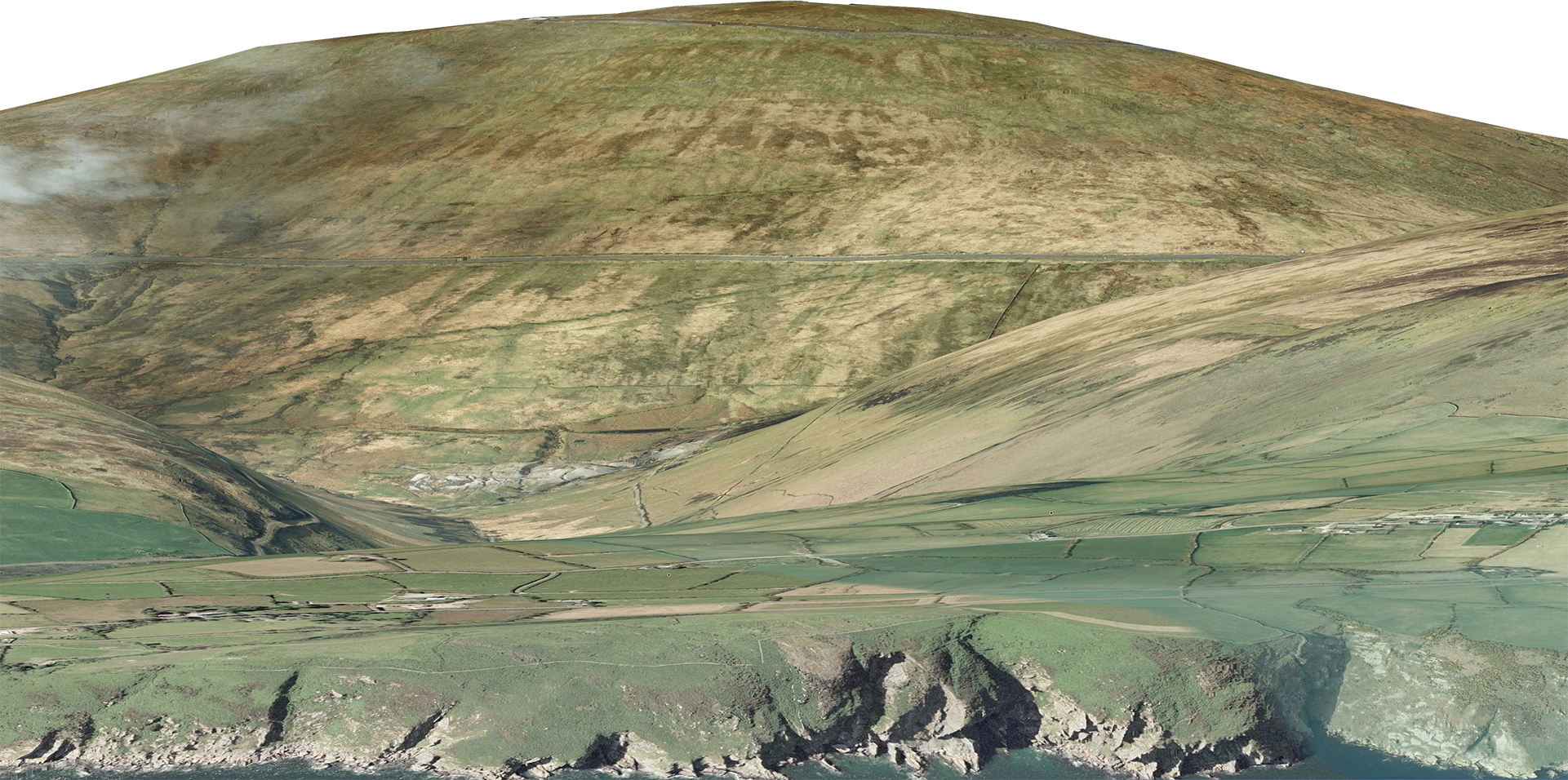
The video shows a portion of the Isle of Man from the waterline of a beach in Blackpool, at a distance of roughly 65 miles, and claims that this should be impossible on a globe, therefore the earth is flat.

Most flat earth videos and arguments are pretty flimsy and easy to debunk... but I'm not sure what's going on here, and am honestly stumped, because as one if the commenters on the video pointed out, even using the calculator here and accounting for standard refraction, even the peak of Snaefell should be hidden from view.

I did notice that there are some turbines in between the camera and the island. Despite being very tall, enough of their height is hidden that their blades appear to be scraping the water, and are heavily distorted, so my guess is that refraction is at play here, but even still, this seems to be a bit extreme.
 
Last edited:
The comments on the youtube channel seem to questioning the claim of location and camera direction. Can you provide a map that would show us the turbines in line with the isle of Man?

Provide a height of the isle of man. Tell us the the youtube video gives us no data other than the title of the video.

The island's terrain is varied. There are two mountainous areas divided by a central valley which runs betweenDouglas and Peel. The highest point in the Isle of Man, Snaefell, is in the northern area and reaches 620 metres (2,034 ft) above sea level. https://en.wikipedia.org/wiki/Geography_of_the_Isle_of_Man
Content from External Source
6.PNG


upload_2018-7-1_23-57-2.png

one of the more recent comments says:
Miles Davis I'm wondering if we can't figure out the camera angle by the sun. At 0:20 in the video you can see from the shadow of the camera that the sum is very low and slightly to the left of the axis of the camera. If this is taken in the morning, then that means the camera is essentially pointing ENE, or closer to due East. Which means this could not possibly be Isle of Man in the background. If this was in the afternoon, the Sunset is at about 313 degrees at Blackpool in late June, so the camera is pointing possibly towards Black Combe. Again, wrong angle for Isle of Man. Black Combe is about 1960 ft in height, and at 30 miles distance if we take the correct angle in consideration, only 600 ft of the hill will be below the horizon. So, it seems to me, the dishonesty of this is readily apparent. Any Comments.

https://www.timeanddate.com/sun/uk/blackpool?month=6&year=2018 Edit: Looking at the maps, this could just as well be across Solway Firth from Approx Lat 54.679669° Long -3.543300° and looking the approx. 320 degrees North to account for the afternoon sun angle. Also, 123 feet of wind turbine is missing behind the horizon: https://imgur.com/0OZzneU
Content from External Source
Source: https://www.youtube.com/watch?v=nCaGCUy6XMk&lc=UgyHn4GaatK2VEdiFKB4AaABAg.8i9jfsGgCro8iAitRTk174
 
Most flat earth videos and arguments are pretty flimsy and easy to debunk... but I'm not sure what's going on here, and am honestly stumped, because as one if the commenters on the video pointed out, even using the calculator here and accounting for standard refraction, even the peak of Snaefell should be hidden from view.

There's two possibilites:

1) That's not the Isle of Man
2) That's not standard refraction.

The second one seems the most likely. The camera is very close to the water, which makes the effects of reaction much more significant (basically makes standard refraction be impossible). They should see how much of the island is visible from higher up. What they are seeing appears to be the peak, the last 50 feet or so of the highest point. 99% of the island is hidden by the curve of the the horizon.
Metabunk 2018-07-01 21-23-02.jpg
 
This is irrelevant but bear with me...
Average height for American males is 175.7 cm = 5 ft 9 in (https://en.wikipedia.org/wiki/List_of_average_human_height_worldwide)

But then there is Shaquille O'Neal towering at 2.16 m = 7 ft 1 in
...and Danny DeVito at 1.47 m = 4 ft 10 in

The point? In statistics the average provides no indication whatsoever on the edge cases.

So unless the video is accompanied by experimentally verified values for refraction, it is overly reductive to compare with the standard refraction in the calculator and claim the discovery of an anomaly.

Here is what an official document says about refraction:
source:
SANDIA REPORT SAND2012-10690 January 2013
Earth Curvature and Atmospheric Refraction Effects on Radar Signal Propagation

A common rule of thumb is that atmospheric refractivity is taken care of by k = 4/3.
While this is useful, it is sort of a ballpark, back-of-the-envelope, squinty-eyed, only sort-
of-ok, approximation
. It stems from the approximation that the refraction index of the
atmosphere is linearly dependent on altitude...
Content from External Source
 
Last edited:
That doesn’t look like the Duddon Sands wind farm, which has a far more regular appearance than the distribution of the turbines in the video. This is it:

0BC54137-3175-4052-AF28-B2954FCA5990.jpeg

(Source: https://ecofriend.com/dong-energy-s...laborate-to-generate-389mw-of-wind-power.html)


This is a picture of the wind farm, taken from Blackpool. I imagine it was taken from higher up than the OP video.
79BA2776-CFB7-4483-A963-2F8722051706.jpeg
(Source: https://en.m.wikipedia.org/wiki/West_of_Duddon_Sands_Wind_Farm)

I can’t find the height of the masts, but whilst they can be site-specific they are typically 90m high. (According to the manufacturers: https://www.siemens.com/content/dam...heets/data-sheet-wind-turbine-swt-3-6-120.pdf). So whilst it is difficult to calculate the actual height above sea level a reasonable estimate would be 35-40m based on a blade length of 58.5m.

As was pointed out in the OP the blades are virtually slicing through the water in the video (or at least appear to be). In the photographs above they are clearly and significantly above sea level.

If asked for a conclusion it would have to be that the mast heights in the OP video and the pictures are in fact pretty good evidence of curvature.
 
That doesn’t look like the Duddon Sands wind farm, which has a far more regular appearance than the distribution of the turbines in the video


When standing on the shore at Cleveleys, you can often see the Isle of Man – when the conditions are right.

https://visitcleveleys.co.uk/about/views-across-water/seeing-the-isle-of-man-from-cleveleys/
Content from External Source
This site above has lots of photos (not necessarily at sea level) from Cleveley which is maybe 5 miles to the north. shows the layout of the turbines.
View-of-Isle-of-Man-David-Pennington-2016.jpg

cl.PNG
 
That's a good article in Deidre's link. Scrolling to the end of the article, it gives quite a clear explanation of why refraction sometimes shows more of the IoM than 'should' be visible from Cleveleys.

The Isle of Man Mirage
If you are lucky enough to be in the right place at the right time, you are seeing the Isle of Man with the help of an atmospheric phenomenon.

...

In this instance the layers of differing refractive index cause the rays of light to be bent, and sometimes reflected, downwards.

Under these conditions you can actually see over the horizon, which is why you can see more of the Isle of Man than you strictly should be able to from Cleveleys.
Content from External Source
 
Last edited by a moderator:
Some great images there. From the higher positions you can see more of the Isle of Man, and get a better sense of how much is obscured by the horizon.


You also see how problematic looking right AT the horizon is. The temperature difference between air an water means there almost always a much steeper temperature (and hence density, and hence refractive index) gradient there than there is in the air even a few tens of feet above. In the overcast example the water appears warmer than the air, so there's a little bit of a reflection, a tiny inferior mirage.
 
Last edited:
'Miles Davis' has a video up on YouTube today which pretty conclusively identifies the wind turbines seen in the flat earth video. They line up well with the direction of Scaefell as it would be seen from Blackpool beach (as it occasionally is). Miles also uses one of Walter Bislin's calculators to simulate the effect of various strengths of refraction, and concludes that the land apparently visible in the distance most likely is the Isle of Man, as a result of moderately strong but not freakish refraction. A comment on Miles's video suggests that it might just be a bank of cloud, but Miles doubts this.

md.PNG
 
Last edited by a moderator:
Metabunk 2018-07-03 12-35-53.jpg

29 Jun 2018, 5:51PM BST.
The temperature at Blackpool airport at 6pm BST was 26.5C (79.7F) at 6pm BST on June 29, which is quite unusually warm for the time of day and location: https://www.weatheronline.co.uk/wea...tur&ART=tabelle&RUBRIK=akt&R=310&CEL=C&SI=mph

upload_2018-7-4_10-53-31.png

(Interestingly the temperature actually rose by 1C between 5pm and 6pm, perhaps due to a change in wind direction or lessening of sea breeze.)

The altitude given for the airport weather station is 10 metres, and it is only just over 1km in a straight line from the weather station itself (which is visible on Google Maps) to the sea:

upload_2018-7-4_11-3-47.png


The current sea surface temperature is 16.1C, and probably hasn't changed much in the last week - if anything it will have warmed up a little with the continued hot weather, so it could have been slightly lower when the video was made. https://www.seatemperature.org/europe/united-kingdom/blackpool.htm

upload_2018-7-4_10-59-4.png

So there was quite a temperature gradient over the Irish Sea.


All of which is kind of beside the point. The question to ask the people who claim such sightings are proof of a flat Earth is what has happened to the rest of the Isle of Man? As the comparisons posted by Mick show, the only bit that is visible is the very top of the highest peak.
 

Source: https://www.youtube.com/watch?v=rBdmspnCZyc


This is similar to the Blackpool to the IoM thread, with an important difference, the observer height is claimed to be 45ft from a sand dune in Southport, approx 72 miles away.

The poster does not account for refraction whatsoever, but in any case, allowing for standard refraction should mean the the IoM is entirely below the horizon, with its max elevation of 2037 ft.

Screenshot_2019-02-21_00-19-38.png

The poster claims to see the whole island, and even shows a profile graphic with correct bearings to the edges of the island at 1:00, but then fails to show how these compare to actual bearings in footage (eg at 1:34).

Either:

There is more than standard refraction present, despite the observation height, or
This is not the isle of man, or
The earth is flat :)

I've been unable to debunk the claim, and offer it to the group for analysis please.


add: location 53.63336, -3.037085

iom2.png

stitched.png
 
Last edited by a moderator:
Either:

There is more than standard refraction present, despite the observation height, or
This is not the isle of man, or
The earth is flat :)

It appears to be refraction. Here's a preset in the refraction simulator for this situation:
https://www.metabunk.org/refraction/?~(p~'Isle*20of*20Man*20From*20Southport)_
Metabunk 2019-02-21 07-24-59.jpg

Zoomed in a bit
Metabunk 2019-02-21 07-27-14.jpg

Flat Earth view, no refraction, same zoom as above.
Metabunk 2019-02-21 07-26-32.jpg

Notice how compressed the (globe, refracted) image is - a sure sign of "looming" (refraction raising things over the horizon)
 
Last edited:
Nice! Thanks Mick. Would you mind explaining the subplots in the refraction simulator a little further? In the left subplot, does the blue line represent standard refraction? What do subsequent red lines represent?
 
Nice! Thanks Mick. Would you mind explaining the subplots in the refraction simulator a little further? In the left subplot, does the blue line represent standard refraction? What do subsequent red lines represent?
The red and blue lines are light paths. Red are those that are above the horizontal plane at the camera.
 
Nice! Thanks Mick. Would you mind explaining the subplots in the refraction simulator a little further? In the left subplot, does the blue line represent standard refraction? What do subsequent red lines represent?

And see this video explanation:

Source: https://youtu.be/8zzEWy5SGKg?t=307


I discuss that window at 5 minutes in.

I know I did not do the best job of explaining - so please let me know what is not clear.
 
Back
Top