• MH370 speculation has become excessive recently. Metabunk is not a forum for creating theories by speculation. It's a forum for examining claims, and seeing if they hold up. Please respect this and keep threads on-topic. There are many other forums where speculation is welcome.

Debunked: Exploration company "Georesonance" believes it may have found MH370

It already smelled rat from the beginning when they showed such a set of precise sat photos for the "plane" under the deep sea---US most advanced spy sat would envy it. This claimed "technology" would detect any strategic nuclear subs of US and Russia have and blow away their crucial "second strike" capability. If it exists, the US and Soviets would chase it like blood hounds and grab it by any means--killing, bribing, silencing,etc. before anyone else even noticed it. Instead, we see all the media without normal heads stinging it like flies---which is exact the free advertisements this scam needed to attract suckers into the trap. If they did have the "tech", they even didn't want expose to the public, they would find all the treasures buried under the sea for thousands of years for trillions dollar worth.

An Australian company based on Ukraine technology? Tell me it didn't smell rat!
 
If it exists, the US and Soviets would chase it like blood hounds and grab it by any means--killing, bribing, silencing,etc.
Well, Soviets would not need to bribe anyone, since Ukraine was the part of the Soviet Union, so it was theirs. And as for the recent time - since a few days the Crimea, including the Sevastopol University (which in words of Mr. Kursa owns the "nuclear reactor" used for the miraculous conversion of plain photos into mineral maps) belongs again to Russians, so they have the "nuclear reactor" back again too. Luckily enough for Mr. Kursa, Russians did not cut the connections between the Sevastopol University and GeoResonance. Mr. Kursa must a supporter of the Russian grab of Crimea :)
 
I often wonder whether these con men, just like doctors or car dealers, have annual conventions they attend in order to network with each other and review the latest scam technologies and product offerings...

They DO it's called the internet!!! But, I have drawn conclusions that most of the official conspiracy theories we know today are actually formed by groups of conspiracy theorists all agreeing that only they have the secret knowledge required to save the world. If only more people listened to them and their ideas...The irony here is that in making their theories, they end up becoming the very things/group of people they are apparently fighting against.
 
The technology is a bunch of crap but why would anyone go in front of the world and make fools of themselves and their company? I think the key here is that Georesonance never said they found Flight 370 they said they found an aircraft. Could be 370 could be another airplane. The thing is if they do find a plane in that location regardless if its 370 or another plane the company will gain instant credibility and I bet a lot of business too. Tell me what news station wouldn't cover the story?? The interesting part about the planes location, other than its perfect alignment is its proximity to land. I believe they will find an airplane in that location but it wont be 370. It might be one or the many planes that was lost and never found over the last 40 or 50 years and stumbled across by someone by accident and Georesonance has the location or perhaps it will be a plane that was placed there intentionally. Maybe a smaller plane that was towed and dumped into the ocean which would explain why its so close to land. If people believed this technology really existed, imagine its value?? A company going public selling millions of shares well worth the small investment of dumping a small, old plane into the ocean. I haven't seen any scale as to the size of the plane that Georesonance has found. Does anyone know if the spectral images fit a 777 size wise?
 
I am a newby driven here by this particular story as it happens to have been my scientific field for over 30 years. Correct me if I am wrong but the claimant company's science is as follows:

1. download a free Landsat image (which contains hidden high frequency signals for metallic elements)

2. make an analog film negative of band 4, 5, or 7 (IR bands, can't tell which one). Presumably the hidden high frequency signals migrate from the digital data to the film.

3. make a sandwich with the negative, "a wafer", and an x-ray sensitive film plate

4. bombard the sandwich with gamma waves and alpha particles. (Probably doable in Ukraine but nuclear reactors might be in short supply in Adelaide, so lets assume you utilize a surplus dental x-ray machine.)

5. the "elemental signatures" migrate to the x-ray plate.

6. develop the x-ray plate per standard photographic methods

Now comes the good part....

7. subject the x-ray film to tuned high frequency electricity to produce a digital Kirlian image on a PC. (wiki "Kirlian" to see that the term "pseudoscience" comes up a lot.) Kirlian images are used a lot to produce fuzzy blobby images of "ectoplasm" and "ghosts".

8. produce a fuzzy blobby airplane at the bottom of the ocean

Wow, isn't science amazing!
 
I am a newby driven here by this particular story as it happens to have been my scientific field for over 30 years.

Also a newby driven here by the possibility of being able to talk about this with someone who can actually understand the technical claims :). May I ask what exactly is your field of expertise?

1. download a free Landsat image (which contains hidden high frequency signals for metallic elements)

Has it been mentioned somewhere that they are using Landsat? Also it has been mentioned they use both satellites and aircraft but it's unclear to me which one is used for what, especially in this case.

2. make an analog film negative of band 4, 5, or 7 (IR bands, can't tell which one). Presumably the hidden high frequency signals migrate from the digital data to the film.

Making an analog film out of a digital picture would certainly sound like more than odd if that's what you mean. Hard to believe they would be doing that.

4. bombard the sandwich with gamma waves and alpha particles. (Probably doable in Ukraine but nuclear reactors might be in short supply in Adelaide, so lets assume you utilize a surplus dental x-ray machine.)

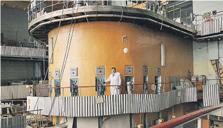
My understanding is that the actual work is being performed in Ukraine in Sevastopol National University of Nuclear Energy and Industry, who actually have an research reactor, and it has been mentioned that an actual nuclear reactor is used at some stage.
 
7. subject the x-ray film to tuned high frequency electricity to produce a digital Kirlian image on a PC. (wiki "Kirlian" to see that the term "pseudoscience" comes up a lot.) Kirlian images are used a lot to produce fuzzy blobby images of "ectoplasm" and "ghosts".

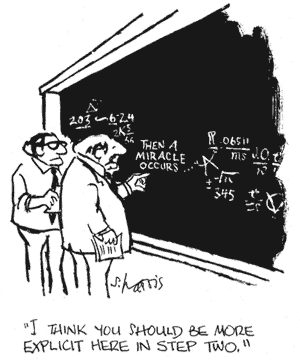
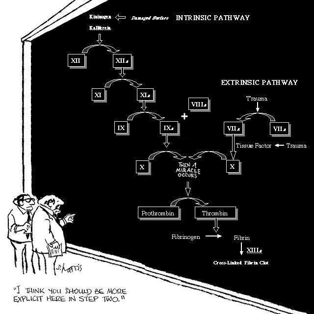
That reminds me of a well known cartoon with two guys in lab coats standing in front of a blackboard showing a complex process chart. All the boxes on the chart funnel down to a single box labelled "and then a miracle occurs". The caption was "I think we need to expand on this a bit".


Last edited by a moderator:
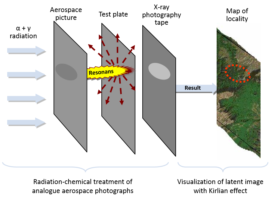
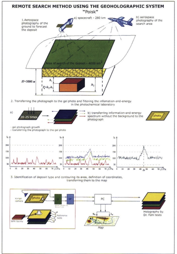
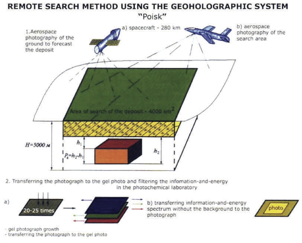
David Coulter has it basically right in his post above. Of course, if presented with it in this way, GeoResonance will always offer an evasive answer, telling that the process is much more complex and cannot be disclosed. They already claimed being using 20 different technologies. However, the workflow as shown by David above is basically exactly what Transcomplex (one of the mother companies) shows in the following diagram on their website at http://transcomplex.uk.com/en/explore/remote-sensing-areas-using-satellite-images:


It is also discribed in a similar way at another partner website of the GeoNMR company here: http://www.geonmr.com/

How does “GeoNMR” technology work?

The first part of our work uses analog space picture of specified territory, which will be activated inside of research nuclear reactor. It is necessary for «revelation» of hide information about required substance.

Analog photo can give the wave information about substance as good as the real substance. Signal intensity from the substance depends only from the volume of the substance and does not depend from the presence of obstacles on the signals path (or depth, kinds of formations and other factors)
Content from External Source
I see a serious problem with the satellite analog photos that they claim to be using - I believe that the last analog satellite photos were probably routinely used only till around 70's (and perhaps not even then). So to get the analog photos, David is right that they have to print out the digital photos first. And of course David is right that it is an incredibly hilarious idea.

This is their nuclear reactor processing the analog photos:
 
Last edited:
I see a serious problem with the satellite analog photos that they claim to be using - I believe that the last analog satellite photos were probably routinely used only till around 70's (and perhaps not even then). So to get the analog photos, David is right that they have to print out the digital photos first. And of course David is right that it is incredibly hilarious idea.

And just to be clear here, it's hilarious because it's so utterly meaningless. It's magic being passed off advanced technology. It's not just that it makes no sense. It's so nonsensical that it's hard to explain why it makes no sense. But basically you can't get more information out of a digital image by converting it to analog. It is necessarily limited to what is in the digital image, and will always lose information when you print it out.
 
David Coulter has it basically right in his post above.
...
I see a serious problem with the satellite analog photos that they claim to be using - I believe that the last analog satellite photos were probably routinely used only till around 70's (and perhaps not even then). So to get the analog photos, David is right that they have to print out the digital photos first. And of course David is right that it is incredibly hilarious idea.

Seen this?: http://agrivice.com.au/media/PM-2.pdf

First of all according to that, there's a satellite involved with an orbit height of 280km. So it's not Landsat (Orbit height 700km+). We are now talking about someone who actually has their own nuclear reactor, so the satellite might also be sort of their own (some ex-military sat released for other uses). It's apparently used used for spectral analysis but unclear if it has anything to do with obtaining those analog photos or just used for some initial wider area spectral survey.

The analog images seem to be collected with a plane, so I don't think there's any hilarious digital->analog conversion there. Also there is some kind of laser beam modulation involved during the imaging. It's unclear to me if that is done by the same plane which does the imaging.
 
I see a serious problem with the satellite analog photos that they claim to be using - I believe that the last analog satellite photos were probably routinely used only till around 70's (and perhaps not even then). So to get the analog photos, David is right that they have to print out the digital photos first. And of course David is right that it is an incredibly hilarious idea.

Even the idea that mylar/emulsion film can contain EM spectrum beyond the visible and maybe near visible is laughable. The products of NMR are in the VHF and UHF range, which is far too large wavelength to focus with a lens, and film is not sensitive to radio frequencies (never mind it doesn't penetrate water, and doesn't spontaneously emit from atoms without a huge magnetic field excitation).
 
Seen this?: http://agrivice.com.au/media/PM-2.pdf

First of all according to that, there's a satellite involved with an orbit height of 280km. So it's not Landsat (Orbit height 700km+). We are now talking about someone who actually has their own nuclear reactor, so the satellite might also be sort of their own (some ex-military sat released for other uses). It's apparently used used for spectral analysis but unclear if it has anything to do with obtaining those analog photos or just used for some initial wider area spectral survey.

The analog images seem to be collected with a plane, so I don't think there's any hilarious digital->analog conversion there. Also there is some kind of laser beam modulation involved during the imaging. It's unclear to me if that is done by the same plane which does the imaging.

I see they have the same claims in there as on the Georesonance site.


http://georesonance.com/georesonance-geophysical-survey-projects.html
 

Attachments

  • PM-2.pdf
    3.5 MB · Views: 1,072
Seen this?: http://agrivice.com.au/media/PM-2.pdf

Also there is some kind of laser beam modulation involved during the imaging. It's unclear to me if that is done by the same plane which does the imaging.

The laser is a separate process they claim to use for making 3D mineral surveys on the ground. They suggest a red laser can elicit NMR reactions from a sample (e.g. oil) which (somehow) modulates a UHF carrier, which is projected into the survey area at an angle, then someone walks across the survey area to pick up the sympathetic resonances from the ground. And then a miracle occurs.
 
So this is the technology they use. Irradiating printouts of digital photos until they "resonate"
 
I see they have the same claims in there as on the Georesonance site.


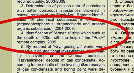
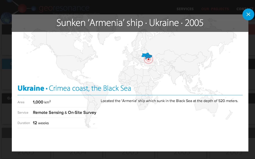
Note the difference in wording to what GeoResonance says. GeoResonance says it's located but in that document they list works that have been executed and they do not exactly state that they have located the ship or that the "identification work" was successful. Also even that seems to be a translation from the original text on the right so there's a fair chance they didn't claim or mean an actual discovery but it was altered in translation.

The projects listed by GeoResonance are not really their own but references for the technology, which is owned by that university in Sevastopol, where the actual work is also mostly done. Even though they state it all as if they have actually done it by themselves.
 
It's very much like Voodoo, if you burn in a fire a pouch containing a lock of hair from someone you are trying to find, the ashes will reveal their whereabouts. Except instead of hair, use aluminum, and instead of fire use a nuclear reactor.
 
Thanks for the link, bume. I'll have to read through it. The first thing I notice is that the diploma at the bottom was issued in Mongolia to Vitaly Gokh (and others). So this definitely confirms that all these numerous companies have the same origin - Vitaly Gokh, the author of the many crazy theories (pyramids built 65 millions of years ago in Crimea, hollow Earth filled with gas, platinum/golden nucleus of the Moon, platinum/golden/diamant nucleus of the Mars, etc, etc).
 
Last edited:
I don't think they use printouts or digital pics or even satellite pics at that stage. See for example this statement from today:

http://www.kcra.com/national/malaysia-to-release-first-report-on-mh370/25751178

"GeoResonance said it used spectral analysis from satellite and plane images to reach its conclusion about the Bay of Bengal site."
Yes, but they still claim to be processing the spectral analog photos by a nuclear reactor - you can read it and hear it in many of the recent presentations by Pavel Kursa.

Also, you cannot make any spectral analysis from the satellite or a plane of something buried deep under the sea.
 
The laser is a separate process they claim to use for making 3D mineral surveys on the ground. They suggest a red laser can elicit NMR reactions from a sample (e.g. oil) which (somehow) modulates a UHF carrier, which is projected into the survey area at an angle, then someone walks across the survey area to pick up the sympathetic resonances from the ground. And then a miracle occurs.

But there is this statement in that doc: "Order and obtaining of the required number of aerospace photographs of the investigated territory during simultaneous "highlighting" of the area with laser beam modulated with the rotating electromagnetic field of test holograms"

So that connects the aerospace photos with the laser highlighting.
 
I am loving the new contributors and their additions to the entertainment. My own background is forty years in all aspects of medical imaging, which takes me back to pre-digital days and not an insignificant amount of knowledge regarding film technology... for example the fact that most X-Ray films are primarily, in fact almost entirely sensitive to only the blue and green wavelengths and that they achieve their sensitivity due not to response to X radiation but in fact to the phosphorescent emissions of the sensitizing plates in the cassette between or against which they are sandwiched. Yes, there are some very dense, very expensive industrial NDT films loaded with silver that have greater sensitivity to radiation, but even so the process would not facilitate the generation of a color image in any event since all x-ray films are monochromatic and the layered sensitizing dies required for... forget it, I have to take a moment to stop laughing. Just to head off the next claim, there are only about a half dozen manufacturers of conventional film remaining in the world, and nobody with the coating alley facilities would waste their time developing a specialized emulsion for this purpose since the cost and waste of trials and development would be way out of proportion to the volume of sales generated even if they sold the stuff to GeoScammers for a million per square meter.

Of course the most obvious question is why they cannot simply mimic the process digitally from the raw data, especially since they apparently have the ability to write advanced assembly code for "5th generation" computers such that even Nomad would not be able to find a reason to "sterilize" their perfect process. The idea that you can somehow obtain greater or hidden data concealed within the raw data by printing it (where basically you are just LOSING or distorting data from the raw bitmap RGB) onto some other media is a joke... it would be the equivalent of claiming that one can take a digital audio file and increase the fidelity or find new information by running it through an A/D converter and then recording it onto tape with an analog record head or scribing it onto a vinyl LP. Of course if you played that record backward you might hear, "Frrrreddy is a Devil", so maybe they're onto something after all.
 
Last edited:
Thanks for the link, bume. I'll have to read through it. The first think I notice is that the diploma at the bottom was issued in Mongolia to Vitaly Gokh (and others). So this definitely confirms that all these numerous companies have the same origin - Vitaly Gokh, the author of the many crazy theories (pyramids built 65 millions of years ago in Crimea, hollow Earth filled with gas, platinum/golden nucleus of the Moon, platinum/golden/diamant nucleus of the Mars, etc, etc).

Take a look at this:

http://www.carpathiallc.org/images/documents/Independent Testing Results.pdf

Carpathia LLC is one of those many companies selling this stuff originating from Sevastopol. That document lists the inventors of the "Deep Vision" model which we are talking about. Those are Vitaly Gokh and Mykola Kovalyov.

Apparently "Deep Vision" is now named "Pure Savings" Service by Carpathia.
 
Is that a real thing? Because it sounds a lot like the favourite words of new-age philosophers.

That's the kind of question I hope somebody else can answer, because I don't have the expertise to judge if that makes sense. To me some part of what they are doing makes sense (at least the more conventional stuff others are doing as well like normal spectral imaging), while other parts just sound weird and hard to believe. Especially that seeing deep under the surface stuff.
 
The analog images seem to be collected with a plane
bume, are you telling here that they drop the analog images from the satellite and collect them by plane? Well, that's indeed the way it was done in 50's-60's, so purely technically it is certainly possible. However I wonder how big stock of negatives they have in the satellite and how they restock it, that they do not mind making photos of 2,000,000 km² without any funding. Additionally they claim having done it several times (before and after the accident). To me it sounds as much hilarious as the converting of analog photos in a nuclear reactor. Looks like they are incredibly rich that they can afford dropping of tons of films from the satellite and collecting it by planes.
 
bume, are you telling here that they drop the analog images from the satellite and collect them by plane? Well, that's indeed the way it was done in 50's-60's, so purely technically it is certainly possible. However I wonder how big stock of negatives they have in the satellite and how they restock it, that they do not mind making photos of 2,000,000 km² without any funding. Additionally they claim having done it several times (before and after the accident). To me it sounds as much hilarious as the converting of analog photos in a nuclear reactor. Looks like they are incredibly rich that they can afford dropping of tons of films from the satellite and collecting it by planes.

No, I'm saying (or it seems to me that they are saying) that they use analog images gathered with planes.
 
Well some of those words were used on this page on holograms, just not in that order.
http://holocenter.org/what-is-holography
The hologram is the recorded interference pattern of constructive (intensity peaks) and destructive (elimination) of the superimposed light-wavefronts (the electro-magnetic field). By using a coherent laser light-source and a stable geometry (or short ‘pulse’ duration) the interference pattern is stationary and can be recorded into the hologram’s photosensitive emulsion. The hologram is then chemically processed2 so that the emulsion has a modulated density, freezing the interference pattern into ‘fringes’.
Content from External Source
 
No, I'm saying (or it seems to me that they are saying) that they use analog images gathered with planes.

However that does not seem to be what the various diagrams say. They have both satellites and planes
 
280 km seems rather low too. An imaging satellite would want to be in sun synchronous orbit, which I think is in the 600-800km range.
 
No, I'm saying (or it seems to me that they are saying) that they use analog images gathered with planes.
Do they have invisible planes or how did they manage to fly with planes photographing 2,000,000 km² before and after the accident without anyone noticing it? And how did they manage to do it so fast? All the nations active in the search took 2 months and plenty of planes and ships, and still did not even manage to scan a fraction of that area once. Is their aerial base in Sevastopol? Pretty far to fly too!
 
Last edited:
However that does not seem to be what the various diagrams say. They have both satellites and planes

Yes they have both and that brings me to a couple of things I don't understand assuming I have understood the general idea somehow. So my understanding is that they are probably doing some wider area spectral scanning with satellites first and then more detailed detection with planes with those analog images and all.

First of all, even if it was possible to somehow detect stuff deep under the ocean with that plane based analog imaging nuclear reactor thingy, how can they first narrow the area enough with the satellite so that they would know where to send the planes? What is the satellite supposed to be able to detect to enable that?

Secondly, they have said that these metallic anomalities have appeared on their detected location between 5th and 10th of March (as MH370 went missing on 8th). How come they just happened to have such a detailed information from that spot before this whole MH370 episode started?
 
I don't know anyone claiming to be expert here, just saying the claim seems very dubious. There isn't scorn for those trying to search for the plane, but there is for anyone who would use the disaster to promote a tech scam. It's still undecided as to whether these guys are legit or not, but it is hard to find any proof of their techniques working or even a proper description of what it is.
Yes a simple check of the precise location would be the best test, but we're just people on a forum looking for further information on a claim.

PETE,
The claim is dubious, check it out. How much would it cost to dash there and do this? a fraction of how much they are currently burning per day. What do they stand to lose by checking it out
-Yes you are right it is undecided, which means guys should shut up instead of fishing junk on GeoResonance. You have even called it a publicity stunt.
- The 'people on a forum' can do better than deride real people out there actually doing something apart from typing

Let's look at the cost of this scam to GeoResonance
-If it turns out to be false, they lose even the little business they have. They lose their face completely. Why would they do this?
-Australian companies lose face. Nobody can tell the genuine from jokers there
 
Vooke, why don't you start an exploration fund for a mission to the GeoResonance wreck site? See if you can get Ballard to go out there with a forked stick or something. It's easy to risk the time, money and lives of others from that "armchair", isn't it?

You are praying that GeoResonance is wrong so you can be vindicated. Of all the thousands or millions of companies in the world, one comes up with a plausible suggestion of MH370 location. Not guesswork but a semblance of science behind it and the best you can do is to mock them? Give GeoResonance a chance, you got nothing to lose, they got everything to lose
 
Has it been mentioned somewhere that they are using Landsat? Also it has been mentioned they use both satellites and aircraft but it's unclear to me which one is used for what, especially in this case.
280 km seems rather low too. An imaging satellite would want to be in sun synchronous orbit, which I think is in the 600-800km range.

I agree. They claim to have covered 2M Km^2 so they would have to use a higher orbit satellite to cover that amount of area in less than 30 days. I am assuming they did not spend millions for commercial data or tens of millions to fly airborne imagery (an airborne survey that size would take many months at best, probably more than a year). Landsat 8 would be the logical choice. Plus the imagery is downloadable for free. The other issue is that I don't see how they could get imagery without a lot of cloud cover in that part of the world, or maybe the "resonances" pass through clouds too?
 
Back
Top