Bellingcat Analysis of Satellite Imagery Used In Russian Claims Against Ukraine

Thanks for the link to this MoD Piece. When I went through all the Digital Globe imagery in July 2014, I wondered how the vegetation on the upper left side would show in any image between July 2 and July 14th (as there were no Google-Earth Images within this timeframe), and was especially interested in the one that was made on July 12. Since I'm not Bellingcat and also don't want to spend a lot of money in acquiring this image, I thought I will never know. Now this MoD presentation showed exactly this image from July 12th (Slide 3) in a much higher resolution than the preview image on DG. So thank you very much Trailspotter :) Thanks to your link I can be sure now, that the MoD picture from July 14th was 100 % wrongly dated. I had it at 95 % until today as there was still a slight chance that the vegetation can increase quite a lot within 12 days. But within 2 days, from July 12th to July 14th, that is quite impossible. The last line of defense for correct dating of russian MoD sat images just fell apart.
 
The only difference is that R and B are reversed in the SBU image - RGB=BGR. Spatially the images look identical. It is not clear who remapped the color channels.

Here are the images with RGB mapped correctly and a bit of contrast enhancement...

SBU with correct color channel mapping:
upload_2015-6-17_13-32-19.png

Bellingcat DG:
upload_2015-6-17_13-32-55.png
 
The only difference is that R and B are reversed in the SBU image - RGB=BGR. Spatially the images look identical. It is not clear who remapped the color channels.

Yes the two images are identical. Although SBU did not state the source of their images, it is clear that this image was obtained by them from DigitalGlobe (if we believe to Bellingcat' assurance of the source of their image). This supports my earlier suggestion above that the public release of so many DG images of the conflict area could have been paid for by an Ukrainian governmental agency or its allies. The released images is only a small selection of all available DG images of this area, which is hardly a random one as it was probably done by an interested party.

I'd like to note that the July 17 image newly acquired by Bellingcat was not released in full. The only released fragments are crops of small areas corresponding to the Russian MoD images, like the earlier SBU image. The unavailability of the full swath hinders independent verification of the date by crosschecking it against third party images.

I have compared the cloud coverage on the publicly available high resolution images from DG with the MODIS Terra images, which are taken at approximately the same time of the day. At the 250 m per pixel resolution of Terra images it is possible to distinguish (in the most of them) the runway of the Donetsk Airport near this Ukrainian military base. So far, the cloud coverages on the DG swaths published via Google Earth were consistent with those taken by the Terra satellite on the same specified dates. It remains to be seen whether the same applies to the July 17 image obtained by Bellingcat or not.

PS Here is the Terra image taken on July 17, 2014 at about 08:12 UTC = 11:12 local time. The military base location (red circle) was in clear, but close tho the cloud bank edge:
Donetsk_Terra_20140717_0812UTC.jpg
 
Last edited:
The only difference is that R and B are reversed in the SBU image - RGB=BGR. Spatially the images look identical. It is not clear who remapped the color channels.

They are also slightly skewed and rotated relative to each other.

This, together with the R/B channel error likely indicates they were constructed slightly differently from the same underlying raw data, with different transforms applied to correct the perspective of the satellite. Obviously the underlying images are the same though.
Both images in my post were cropped screenshots of the Russian MoD and Bellingcat's webpages. The "original" MoD image probably was taken from the CBU slideshow on youtube. Could this account for a skew?
 
Both images in my post were cropped screenshots of the Russian MoD and Bellingcat's webpages. The "original" MoD image probably was taken from the CBU slideshow on youtube. Could this account for a skew?
Hard to say, who knows what steps the image goes through along the way? The important thing is that it's the same image.
 
Hard to say, who knows what steps the image goes through along the way? The important thing is that it's the same image.
Sure, it is. Also, both CBU and Bellingcat's version have the same timestamp: 11:08 local time, or about four minutes before the Terra satellite took its image of this area (see PS in my post #83 above).
 
Sure, it is. Also, both CBU and Bellingcat's version have the same timestamp: 11:08 local time, or about four minutes before the Terra satellite took its image of this area (see PS in my post #83 above).

I've compared the Terra image of the Donetsk area on July 17, 2014 with a low resolution preview of the GE01 swath from the DigitalGlobe catalog. There is a good match of the cloud patterns in these images, which were taken less than five minutes apart (in this time interval the clouds moved closer to the airport (yellow rectangular)):
cloud_pattern_comparison.png
This verifies the date of the satellite image in the DG catalog. However, it remains to be seen if the cropped images of the Ukrainian military base came from this particular DG image.
 
Last edited:
Hard to say, who knows what steps the image goes through along the way? The important thing is that it's the same image.

Judging from the difference in spatial resolution I think the original image from the Ukraine was a raw multispectral (MS) image and the Bellingcat image is pan sharpened. I know DG does an approximate geometric correction through a fairly manual control point fitting process to get the imagery within defined mapping specifications. The shift seen in the imagery would be well within the accepted mapping tolerances for the MS resolution vs the panchromatic resolution. I suspect that the US government, which has huge data buy contracts with DG, probably provided the original MS image to Ukraine quickly without manual registration using pan sharpening. Given the interest in the area DG probably did a more comprehensive registration in the intervening time using a broader set of imagery, some of which may have been near nadir look angles; and the shift is probably within the difference of resolution between the MS and pan resolutions and look angles.

Sorry if this sounds like Greek. You can only fully correct imagery that is off nadir (looking to one side or the other vs directly above the target) if you have a full geometric model of the surface. The imagery can then be ortho-corrected using ray tracing to calculate where the image pixel intersects the surface entity, be it a building, vehicle, treetop, or the ground. This translates the image pixel into an accurate XYZ geographic coordinate space. At the resolutions of the DG imagery you would need to generate a stereo pair 3D surface model (expensive) or fly a LIDAR survey (>expensive) to achieve this goal. Thus the registration is approximated using control point matching and either triangulation or 1st order polynomial fits to register the imagery. Given the simple skewing I would interpret the fit as being a 1st order polynomial which allows translation, scaling , and skewing - triangulation would introduce complex mis-fits. As long as the fit falls within documented mapping accuracy standards for the image resolution, all is good.
 
Last edited:
Thanks to your link I can be sure now, that the MoD picture from July 14th was 100 % wrongly dated. I had it at 95 % until today as there was still a slight chance that the vegetation can increase quite a lot within 12 days. But within 2 days, from July 12th to July 14th, that is quite impossible. The last line of defense for correct dating of russian MoD sat images just fell apart

Somewhat OT.... One wonders if the MoD is living in a bubble wherein the Internet, Google Earth, and social media don't exist. The "big lie" is getting harder to to perpetrate. Maybe time stopped there in the 1980's, or Putin has a Delorean with a flux capacitor.
 
Holy mother of... It's 2015. He just might have stolen one off a family of Micheal J Fox lookalikes. And yet we still need... roads, plus my jacket is not self drying, which would have been helpful today.

Sorry for the tangent, that was a bit of a shock to realize...
 
Somewhat OT.... One wonders if the MoD is living in a bubble wherein the Internet, Google Earth, and social media don't exist.
haha. Well I think we can all agree that is not the case. So....something else must be going on. In view of the media campaign at the time they may have just been throwing anything out there. In order to draw attention to a fact that still stands. Ukraine was the only group that definitely had a buk on July 17 2014. After all there was and is a whole raft of unverified or fake evidence (such as the ridiculous intercepted "calls") that came out at the time. So maybe the Russians just did what everyone else did and came out with a story that went beyond the facts.
Without getting too OT , I think it can be demonstrated that bullshit was flying from all sides.. We can start another thread if you think one side is pure as snow.
 
Last edited:
Without getting too OT , I think it can be demonstrated that bullshit was flying from all sides.. We can start another thread if you think one side is pure as snow.

New topics in new threads. And "I think they distort facts just as much" is not a topic. All governments engage in propaganda. . If there are individual claims of evidence that can individually be debunked in individual threads, then that's fine. But Metabunk is not a site for advocacy.
 
Ukraine was the only group that definitely had a buk on July 17 2014. After all there was and is a whole raft of unverified or fake evidence (such as the ridiculous intercepted "calls") that came out at the time. So maybe the Russians just did what everyone else did and came out with a story that went beyond the facts.

Getting back to the OP: What is the evidence that Bellingcat faked or published faked satellite imagery?
 
Panchromatic imagery is broadband covering RGB wavelengths with a single band. This is certainly what the MoD is showing.
There's no way to make such a strong claim of what the MoD might be exactly showing here on a more technical level. Yes it's the standard greyscale but that can have many reasons. For example when using a panchromatic high-res image with one or more other bands to accentuate features resulting in some multilayer image. The usual pan-sharpened version is an example of that but strictly generated to provide a natural looking color hi-res but also causing various forms of spectral distortions. The reason I bring this up is that I find a lot of differences in how soil and vegetation in general seems to render in the MoD image compared to the pan-sharpened versions of DigitalGlobe/WV2. In this post I'll try to substantiate but please refrain from questioning my potential motive of targeting the Bellingcat reports more than I might target the Russian press releases.

In the IR, vegetation would be bright because chlorophyll is highly reflective in the IR (google "red edge"), and that is not the case for the MoD imagery.
That's only because near-IR bands would show digitally some higher number on those pixels. How to assign that to a brighter or darker color is up to the ones compiling the resulting image. More importantly however, there also could be difference in how turbid water or wet soil would render but at lower wavelengths. The moment one is blending multi-spectral images, you're going to see different things but of course not different vehicles, just different patches or accentuated relief for example, which can easily lead to unsubstantiated conclusions about the state of the landscape.

Perhaps it's time for a visual aid: Pan Sharpening of High Resolution Satellite Imagery, 7 July 2004 DigitalGlobe
pansharpening-dg-p5.png

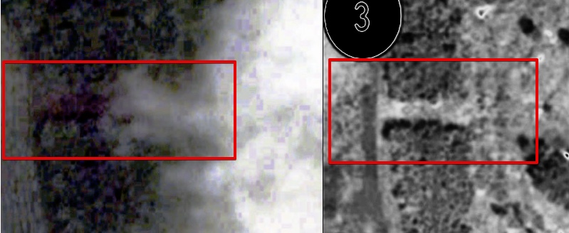
Here you see how multi-spectral bands show vegetation and soil details hardly visible on panchromatic. Although pan-sharpening is a solution, we don't know how the Russians created their image. It's not missing some vegetation as one might expect from panchromatic images, actually, if anything, it seems to have way more dark patches which indicate differences in soil or vegetation which can hardly be all explained by two weeks passing. You can easily verify this at the Bellingcat comparison page, just flip the pictures back and forward and notice how many many features are different in terms of "paths appearing" or soil structure all over the place and in every image! Therefore my suggestion here is that the Russians might be showing a different type of panchromatic-multi-spectral blend or applied algorithm. My suggestion that it might involve more near-infrared was just based on the military dimension of their equipment and the fact that wetter patches would show up darker. But I never wanted to suggest vegetation shows up generally "darker" on infra-red!

There's also a different explanation, from page 19:

pansharpeneing-dg-p19.png

Here you see how vegetation can show up too dark and dense while panchromatic removes too much. the conclusion of Digital Globe of the report is therefore: "Color recovery, especially over vegetation, is poor and won’t satisfy most customers".

So the comparison between the DG imagery and the MoD imagery by Bellingcat is reasonable to anyone with photo-interpretation experience
It would be good to have a list of qualified and experienced analysts reviewing the data. It's in the vacuum of technical reviews that I'm trying to ask the questions which in my view should be always asked when so much is at stake with mass interpretation of remote sensing data.

So, you seem to be arguing that unless you are provided raw multiband DG WV2 data from Bellingcat (which they can't because of licensing restrictions), the Russian jpegs are more reliable.
But the ones making all the claims do not provide us with complete free-to-distribute and analyze sources from WV2 or MoD satellites while both do offer different conclusions. It's unclear how you'd derive from that problem that I'd think "Russian jpegs" would be "more reliable". As I see it I'm looking at two claimants who do not provide the actual source data and metadata while both are releasing JPGs created in Photoshop to the public who are then asked to make up their own minds. Bellingcat has the advantage that the product dates of DigitalGlobe appear to confirm their version but the Russian MoD would have way more to lose over time since the final verdict will not be made in the public forums but with the formal investigators who I assume have received all originals and metadata from all parties. But that's my assumption which I think is reasonable enough.
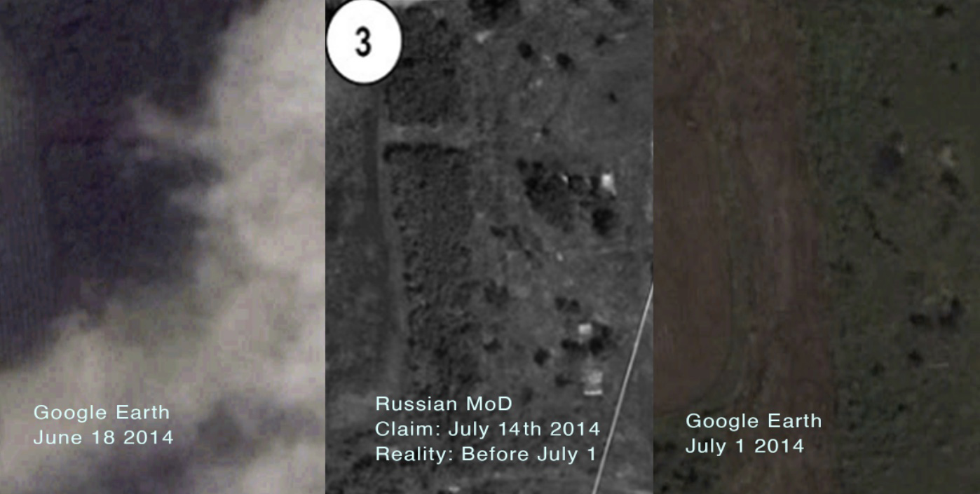
 
Last edited:
New claim: Ukrainian military can create forests as easily as removing them!

Check out Google Earth: 48°05'56,52" N 37°45'06,13" E

ukrain_stip_ge_20120407.pngukraine_strip_ge_20120507.png

2012-04-17 . . . . . . . . . . . 2012-05-07​

Three weeks to grow that all back! Like in 2014 but in reverse!
I can see no significant differences. All trees/shrubs seem to be in the same places, but there are more leaves on them in May than in April.
 
I can see no significant differences. All trees/shrubs seem to be in the same places, but there are more leaves on them in May than in April.

Belingcat and many at this forum argue for something else when very similar pictures were reversed in date in 2014.

The differences are due to spectral processing and some soil/moisture differences. Now go back to the Bellingcat "analysis" and understand there's really only there what you want to see. A more technical background has already been provided by me , this is just a visual help using the very same area.

As for the weak "there are more leaves " in May than in April, this is not true when browsing through the imagery of other years. It's also a bit of a stretch, it's completely overgrown what seems "barren" before. It's a different spectral signature filtered through differences in blending multispectrals. You are right though, all is "in the same place". Like in the Russian pictures, once you learn to distinguish between soil, spectral response and actual features or trees.

Another way to learn is to see how in all the Russian spy imagery various roads, paths and other soil areas all appear quite differently. Landscape textures and elements show in one which are not in the other. This is not unusual at all and prove nothing. In my opinion of course but unless someone here actually does this analysis for a living, any claim for landscape modification remains pretty weak.
 
As for the weak "there are more leaves " in May than in April, this is not true when browsing through the imagery of other years. It's also a bit of a stretch, it's completely overgrown what seems "barren" before.
I grew up 100 miles southeast of that place. The climate there is continental one, in which spring is often late, but catches up very fast. The changes of foliage are also pretty sharp: trees go from naked to fully covered in just two to three weeks.
It looks like in 2012 the spring in Donetsk region was late (Taken on April 16, 2012):
IMG345 by Jimmy's andyphotos, on Flickr

but the first week of May was like summer (Taken on May 6, 2012):
IMG_0649 by Alex_Ermochenko, on Flickr
And here is something in between (Taken on April 25, 2012):

Source: https://www.flickr.com/photos/57870616@N05/6967051738/
 
Last edited:
Thanks, but that's demonstrating my larger point because those camera's all clearly have different spectral ranges and frequency responses on top of any changes in foliage. It would be interesting to match satellite pictures of that area with statistic of moisture content in the soil. That's crucial for the type of frequency response one gets, aka the "greening" and soil texturing.

Any higher IR response will change the nature of the pan-sharpened "merged" image. This is easily demonstrated by browsing the area in Google Earth through the years. Green landscapes and more barren brown ones pass by but not as response so much to any seasonal change but likely something related the moist content and the method used in that particular batch or satellite company to deal with the various multi-spectral merges.

Hence the Russian satellite imagery (panchromatic: where you will see different soil features by design) showing already way more IR response for useful soil and track analysis. And I already mentioned before that since (around) Juli 2014 DigitalGlobe started to release higher definition and better quality pan-chromatics to the public, meaning they will contain a supposedly more realistic frequency response: less "greening" and soil texturing masking any "realistic" bird's eye view from above.

This is all not meant as proof of any claim just as an alternative line of thought, resulting in wondering if Bellingcat's analysis could even be done at all without all the source material, all multi-spectral and panchromatic imagery. Not Google Earth or pan-sharpened "optimized" versions which also might change with each batch one views (as the algorithms sometimes change). So I keep asking for the release of "raw" data, at least from anyone making claims based on this data beyond some visual eyeballing and estimating. Because that's just not proper research.
 
Thanks, but that's demonstrating my larger point because those camera's all clearly have different spectral ranges and frequency responses on top of any changes in foliage.

His post had nothing to do with different camera's spectral ranges. It just shows how fast the vegetation can change.

Your musings on the different imaging capabilities are moot, as the photos show sufficient physical changes that could not be attributed to different wavelengths.
 
This is all not meant as proof of any claim just as an alternative line of thought, resulting in wondering if Bellingcat's analysis could even be done at all without all the source material, all multi-spectral and panchromatic imagery. Not Google Earth or pan-sharpened "optimized" versions which also might change with each batch one views (as the algorithms sometimes change). So I keep asking for the release of "raw" data, at least from anyone making claims based on this data beyond some visual eyeballing and estimating. Because that's just not proper research.

does that even exist?

Because asking for something that does not exist, or which is not reasonably available, as the required level of evidence smacks of trolling to me.
 
does that even exist?

Again, it's irrelevant, remember the incredible reach that Herman is making here.


He's suggesting that it's possible that the middle image is not (as it appears) showing trees with a path through it (the image on the left), but is instead essentially the image on the right, but viewed through a different camera that makes it look like the image on the left. He argues this at great length in this thread:
https://www.metabunk.org/confirmed-...-imagery-showing-changes-in-vegetation.t6430/

It's quite obviously wrong. The path through the trees exists in the Russian photos, so the date of the Russian photo is wrong.
 
Back
Top