
You are using an out of date browser. It may not display this or other websites correctly.
You should upgrade or use an alternative browser.
You should upgrade or use an alternative browser.
Woody's observations of contrails in MN
- Thread starter Woody
- Start date
JRBids
Senior Member
If I had an extra 400 bucks I would get it, but my roof and garage door are priorities, not everyone has this $$$ laying around, but, if you are stating you are willing to donate it, I will give you my shipping addressBTW, don't forget the accesories
"They" are poisoning you. Or "you" are giving yourself a heart attack worrying about something that isn't happening, and wasting a lot of time in the process. I'd think it would be a priority to get on with your life worry free (or at least with THAT big worry out of your life), free up a lot of time, or expose this plot.
It is far easier to see further from a higher altitude In fact if you go high enough you can see half the planet! The question remains, from the ground what is the maximum distance one can identify a plane with a contrail?
I think we were talking about estimating how far away a contrail was in the part of the discussion involving how far you can see.
Over the past 3 years we have identified 11 sectors in the Twin Cities area.
Who is this "we" you are referring to?
I looked at your sector map, the sectors appear quite close together in jet flight time.Do you have someone in each sector reporting whether or not there is a contrails in that area? The sectors don't even make sense to me, it would seem to be easier to just spray from one end to the other, or do the planes run out of chem juice that quickly?
JRBids
Senior Member
See Trigonometry I just listed, as I have said since the beginning, the average area of viewing is about 40 miles, from her to Monticello, Others say I can see the weather in the Twin Cities from St. Cloud at a distance of 72 miles, well, they are wrong. Trig calculation supports what I have been saying, try it yourself and look at the pic that started this entire thing in the first place and realize, Mick was wrong and I was right, at least according to the math.
You're handwaving again!!
cloudspotter
Senior Member.
You're handwaving again!!
I think Woody is struggling to think in 3D
solrey
Senior Member
I think Woody is struggling to think in 3D
There's a test for that.
http://psychometrics.akresgr.org/spatialtest/
Let us know how you do Woody.
Ross Marsden
Senior Member.
I struggle to understand what Woody is writing most of the time.
For instance; the photo above with the graticule... (post #161); What is that all about?
(No one has referred to it, so I suppose we are all having difficulties.)
The numbers in the comment do not relate to the photo.
I hesitate to ask Woody for an explanation in case that would make matters worse. No offense intended, Woody, but Crikey Dick!
If we can return to the issue that began this discussion, how far can you see a plane or contrail before it becomes no longer distinguishable?
The contrails in this story were proven to be over 160 miles away, with the portion touching the horizon at about 200 miles.
http://contrailscience.com/los-angeles-missile-contrail-explained-in-pictures/
Last edited:
There's a test for that.
http://psychometrics.akresgr.org/spatialtest/
Let us know how you do Woody.
I only got 12/19
 I'm only a bit above average
")
Woody
Member
Woody
Member
Woody
Member
I agree JB, I just know my math and there is such a knee jerk reaction to distance that I had to take out the trump card and prove through trigonometry that my point is valid and everyone else is guessing, I take out the guessing game."They" are poisoning you. Or "you" are giving yourself a heart attack worrying about something that isn't happening, and wasting a lot of time in the process. I'd think it would be a priority to get on with your life worry free (or at least with THAT big worry out of your life), free up a lot of time, or expose this plot.
I think we were talking about estimating how far away a contrail was in the part of the discussion involving how far you can see.
Who is this "we" you are referring to?
I looked at your sector map, the sectors appear quite close together in jet flight time.Do you have someone in each sector reporting whether or not there is a contrails in that area? The sectors don't even make sense to me, it would seem to be easier to just spray from one end to the other, or do the planes run out of chem juice that quickly?
Last edited:
Woody
Member
Ross, the angle on the right is the degree of elevation. Take this degree while looking at an object and look up the "sine" for that number. Then divide it by the known altitude to get your result, This will tell you haw far you must go to find that object directly overhead. If you take your cell phone camera on the widest angle, if it is like mine, it will be about 50 degrees. If you place the horizon on the bottom of your camera (Picture the long way not up and down) when that plane is off the camera coming over your head and disappears from your camera it is now less than 10 miles away. Remember, at 30,000'.I struggle to understand what Woody is writing most of the time.
For instance; the photo above with the graticule... (post #161); What is that all about?
(No one has referred to it, so I suppose we are all having difficulties.)
The numbers in the comment do not relate to the photo.
I hesitate to ask Woody for an explanation in case that would make matters worse. No offense intended, Woody, but Crikey Dick!
Woody
Member
Wish we had skies like this, beautiful pic. World record is over 700km though in Antarctica while viewing a mountain on a perfect day.The contrails in this story were proven to be over 160 miles away, with the portion touching the horizon at about 200 miles.
http://contrailscience.com/los-angeles-missile-contrail-explained-in-pictures/
Last edited by a moderator:
Woody
Member
I think everyone forgot about math, its not about 3D, its about TiggyD.I think Woody is struggling to think in 3D
solrey
Senior Member
View attachment 4440May I remind everyone that this discussion began with this picture and Mick saying it was 100 miles away, I said it was far less, maybe 40 or 50 miles. You all believe Mick and not Math, this is the problem. Based upon the above information, with the end of the cloud being visible at 6 degrees with the horizon at -1. Use your trig guys, you will find many problems with Micks drawing and I will explain it by this one. To achieve the distance you take the sine of your angle and divide it into your altitude, I will even give Mick some room for error by calculating this at 6 degrees. The sine for 6 degrees is .10452846326. Distance is 287,003', or 54.36 miles. Curvature of the earth and refraction would also need to be taken into account but this would be very accurate for the purpose of this discussion. It could be 100 miles away but elevation needs to be at 60,000'. If the altitude was 15,000, it would be 1/2 the distance or 27 miles away. Elevation alters everything in the equation and no drawing can have any form of accuracy for all altitudes, this is insane and holds absolutely no merit, facts or foundation. After closer analysis of Micks drawing, this appears to be accurate for 40,000', nothing more or less. There has to be a specified drawing per elevation, no other way. Ask your math teachers. So, who is right?
But you're calculating to the closest edge of the cloud layer. I can see detail in the clouds down to at least the 3 degree mark, add the 1 degree offset and at 4 degrees and 30,000 feet you're looking at over 70 miles away. At 35,000 feet and 3.5 degrees it would be 98 miles away.
I'm sure most of us can do the math so don't be thinking we're stupid, and we also know that on clear days we can see high altitude clouds and/or contrails from 100 miles away. I can regularly see mountains over 80 miles away and the atmosphere is usually quite hazy due to prevailing winds and our proximity to the Pacific. Despite the cloud layer in your pic, the "seeing" looks pretty clear and I know I could see a contrail at normal cruising altitudes from 100 miles away in conditions like that.
Pete Tar
Senior Member
...May I remind everyone that this discussion began with this picture and Mick saying it was 100 miles away, I said it was far less, maybe 40 or 50 miles. ...
I thought there was a debate about you saying it's *impossible* to see a contrail 100 miles away, with an implication that the trail may be further than you think, but not saying it *was* 100 miles away, just that it could be.
I can't comment on whether you've proved what the distance is.
MikeC
Closed Account
View attachment 4354 There we go, cntl - v command to override is needed, pass it on in the tips section. Now, check out this cloud
The bit at the right is almost on the horizon so certainly looks like it is ~100 miles away to me. to the left of that it looks like it is getting closer.
MikeC
Closed Account
Woody
Member
Nope, its about this pic, conditions vary around the planet and some people say they can see storms in Bloomington where my dad lives 72 miles away from the ground in St. Cloud, I say, come show me! Our conditions vary greatly with the vast amounts of water, some 17,000 lakes and coutless swamps causes a great deal of water vapor to rise, and this water vapor is warmer than the surrounding atmosphere causing a limitation is our ability to view very far into the horizon. Other went off on tangents making claims even that one can see the moon? Bringing back to the issue, these trails remain for hours and never dissipate on a daily basis here, and this is not normal. There was so many of these today we lost count, and none of the planes we saw were on Flightware, and any commercial flights on Flighware , the few there were on our drive, none were ever visible. It appears many of the flights are being generated out of North Dakota here.I thought there was a debate about you saying it's *impossible* to see a contrail 100 miles away, with an implication that the trail may be further than you think, but not saying it *was* 100 miles away, just that it could be.
I can't comment on whether you've proved what the distance is.
Ross Marsden
Senior Member.
What is that scale to the left?
What is the implication for your trigonometrical mathematic calculations if it is not zero?
What is the implication for your trigonometrical mathematic calculations if it is not zero?
cloudspotter
Senior Member.
What is that scale to the left?
What is the implication for your trigonometrical mathematic calculations if it is not zero?
https://sites.google.com/site/geocamdoc/mainscreen
Bill
Senior Member
Yeah! 13 out of 19.There's a test for that.
http://psychometrics.akresgr.org/spatialtest/
Let us know how you do Woody.
Woody
Member
I have made claims to viewing distance to the horizon and viewing Aircraft and contrails here in Minnesota ONLY! I have acknowledged that areas around the nation are not the same as here and have acknowledged that a mountain has been seen at a distance of over 700km in Antarctica on one occasion, but also understand this is not a plane or contrail by understanding the vanishing point. I have proven through mathematical configuration the inaccuracy of the trail elevation of Micks drawing and the distance has to be reduced by 1/2 for aircraft flying at an elevation of 1/2 the altitude. The only way to judge the distance of a plane is through triangulation, the picture is not accurate and can be very deceptive and is a close guess with a great amount of variations. These variations have NOTHING to do with understanding 3D, its understanding perspective and vanishing points along with the laws of a right triangle. This also means you MUST also be on flat ground. If you elevate yourself you loose your calculations as you shift the right angle ( 90 degree corner) altering your figures. Knowing this, you may be able to see a long way where you are, but you can't here. Bloomington to St. Cloud is 72 miles by road, and there is absolutely NO WAY you can view any activity or even storms from that distance here. he airport is just a few miles from his location. I tell people here that other people from around the nation state that they can see one another s weather system, Bloomington and St. Cloud. They get a good chuckle, its common knowledge here that this is not possible. In the dead of winter this may have been possible at one time, but due to the increased amount of activity, a nuclear power plant and coal fired plant installed between them, along with the massive amounts of cars, homes and business's, the horizon remains greatly impaired. So I agree, 100 years ago it may have been possible to see it here, but everyone here knows its impossible. Everyone here also knows that something has altered in the sustaining trails left behind by so many aircraft. If you dispute this, then I believe it is time to take a trip and stop trying to judge something you have no knowledge of. Sustaining trails from aircraft was at one time an occasional occurrence, now its daily, it has changed.
Woody
Member
Here where I live, in its natural state, you could never see the Horizon through the forests, only out in the middle of a lake could it be viewed. This gives you one simple understanding that differs from many other areas and the results are vast amounts of transpiration in the evenings. Continental climate is another driving factor here. Both are not driving factors around much of the nation, esp California and Florida, or the entire East and West coast.
scombrid
Senior Member.
Our conditions vary greatly with the vast amounts of water, some 17,000 lakes and coutless swamps causes a great deal of water vapor to rise, and this water vapor is warmer than the surrounding atmosphere causing a limitation is our ability to view very far into the horizon.
Dewpoints and relative humidity tend to be a lot higher here in Florida than in Minnesota. Visibility is great here most of the time.
Continental climate is another driving factor here. Both are not driving factors around much of the nation, esp California and Florida, or the entire East and West coast.
Florida's climate is dominated by continental airmasses from October to April/May. There is a continental airmass parked over me in Brevard Country right now. During the wet season our airmasses are generally maritime subtropical.
The east coast is dominated by continental airmasses pretty much year-round with incursions of maritime subtropical air from time to time.
scombrid
Senior Member.
I have made claims to viewing distance to the horizon and viewing Aircraft and contrails here in Minnesota ONLY!
Air quality is better in Minnesota than around NYC. JRBids showed an illustration of viewing trails at great distance in the NY areas when visibility near the ground looked pretty bad.
I have proven through mathematical configuration the inaccuracy of the trail elevation of Micks drawing
Not really.
cloudspotter
Senior Member.
Woody. Picture of a trail or plane low in the sky with that app. Tell us how far away you think it is and how you reached that conclusion.
scombrid
Senior Member.
What is special about contrails and cirrostratus clouds? We see clouds like that everywhere associated with particular types of weather systems.
You had a vigorous low pretty approaching. The sky in your photo is exactly the type of sky that usually precedes such weather.
Last edited:
Jay Reynolds
Senior Member.
Well, it's Friday. I explained to Woody what he needed to do on Monday. He has figured out how to document the plane passing over, but hasn't shown a Flightaware screen capture for the event. Do you even know how to do this, Woody? Just ask if you are not able. Don't try and take a picture of your computer screen using a camera, not clear enough. Simple instructions:Like I asked you a long time ago, you need to document your case far better before you can make conclusions that what you see is anything out of the ordinary. Try again and pay attention to detail, documenting the whole event including the Flightaware screen shots as the plane passes over, time, lat/long, cardinal direction of the shot(use a compass away from metal) and let us see the whole thing. You can even order the FAA flight data for the event which would prove your case of unidentifiablility if true. Until you do all of this, you are wasting time.
1. get Flightaware up on your screen showing ~ 100 mile radius.
2. Hover your cursor over your physical location on the screen.
3. press "print screen" on your keyboard.
4. Open "Paint", it is in Windows accessories, and press "Paste".
5. Go to "File", "save as", select the location you want to save the file and save it as a .JPG image.
Kapiche?
Jay Reynolds
Senior Member.
Woody, you say that you actually have been able to identify some planes.Woody. Picture of a trail or plane low in the sky with that app. Tell us how far away you think it is and how you reached that conclusion.
You don't seem to have applied logic or don't understand how to begin providing proof for what you claim. I don't know what your problem is, bu in case you need someone to hold your hand and explain how to do an experiment, here is a suggestion:
So, here is how you can prove your claim that a contrail isn't visible for more than 30-40 miles away.
Do this also with a plane which you have definitely identified using Flightaware, leaving any sort of contrail, persistent or not.
Document the whole event:
Take a photo of the plane showing
date/time
lat/long
elevation
make a screen capture of Flightaware
record the Flight number
Then, start showing us some further out from overhead, go further, then further, ever further, closer to the horizon, always identifying the plane down towards the horizon.
Eventually, you will see and document your claim that a plane's contrail close to the horizon is no more than 30-40 miles away.
Of, you will find that you were wrong, and then you will have proven yourself worthy of being correct.
Or, keep doing what you have been doing.
Unless you are going to take ALL the above steps, don't bother showing us ANYTHING else.
Come on, make my day!
Jay Reynolds
Senior Member.
Hey, Woody.A straight up answer is required from you. When did you first see "chemtrails" around Minnesota?
cloudspotter
Senior Member.
Hey, Woody.A straight up answer is required from you. When did you first see "chemtrails" around Minnesota?
Good luck

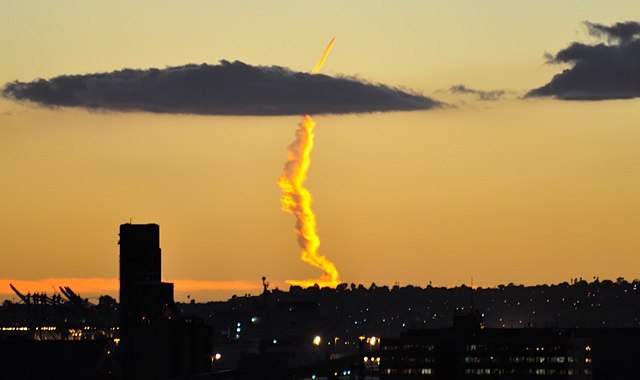
View attachment 4443Eventually as I post these as often as I can someday someone may think, I should go there and check this out.
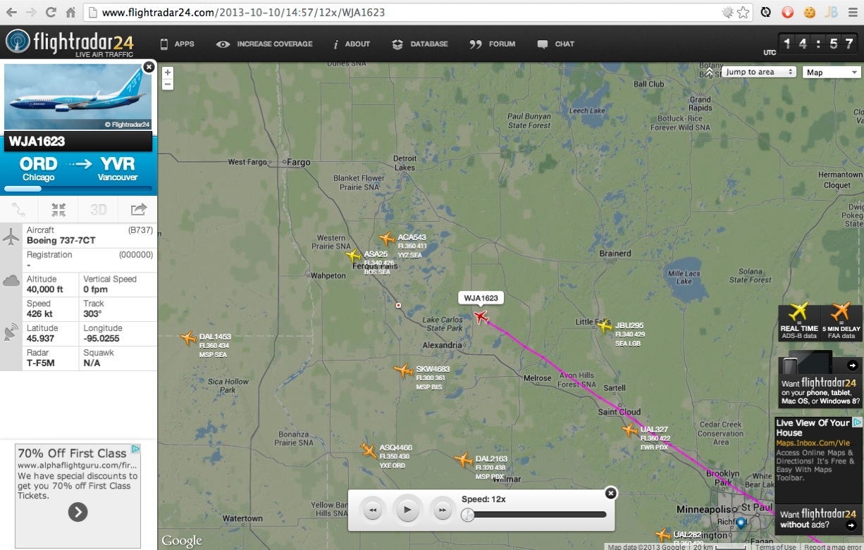
Did you try to identify that tiny fresh trail there?
Looks like WJA1623, which at that point was about 20 miles to the west of you.
Last edited:
MikeC
Closed Account
Eventually as I post these as often as I can someday someone may think, I should go there and check this out.
So you intend to spam this board??
Woody
Member
Actually, yes we did, along with a few others, and like I said, we could not find a single one.Did you try to identify that tiny fresh trail there?
Looks like WJA1623, which at that point was about 20 miles to the west of you.
Last edited by a moderator:
Woody
Member
We started to notice them in the spring of 2010 and they seemed to increasing more as the year went on, it appears to be the same today as it was in 2011Good luck
Actually, yes we did, along with a few others, and like I said, we could not find a single one.
Oops, I got that the wrong way round, looking East, not West. Hang on.....
Similar threads
- Replies
- 3
- Views
- 1K
- Replies
- 5
- Views
- 978
- Replies
- 3
- Views
- 1K