solrey
Senior Member
Debunking the youtube video Tornado Creation 201A by WeatherWar101.
https://www.youtube.com/watch?v=wVX8f58IxY0
http://www.ncdc.noaa.gov/oa/radar/radardata.html
After a few minutes of a CONUS radar loop covering four days after tornadoes around Oklahoma City, WeatherWar101 attempts to explain cloud formation with an oversimplified version like something geared for children. In the process of trying to explain evaporation and cloud formation, he demonstrates zero understanding of the hydrologic cycle or water vapor transport in the atmosphere. The vast majority of water vapor in the atmosphere originates from the oceans and most of that water vapor is transported in what's known as Atmospheric Rivers. Nearly all of the rain that falls on the CONUS east of the Rockies evaporated from the Gulf of Mexico, the Caribbean or the Tropical Atlantic.
505,000 cubic kilometers of water evaporated from the world's oceans
72,000 cubic kilometers of water evaporated from land
Seven times the amount of water evaporates from the oceans as compared to land. The Earth's surface is 70% water after all.
http://www.eolss.net/Sample-Chapters/C07/E2-02-03-02.pdf
After some more radar loops he moves onto HAARP and other ionospheric heaters, which I'll pick up in the next post.
Reference links follow...
http://ww2010.atmos.uiuc.edu/(Gh)/guides/mtr/hyd/home.rxml
http://www.nwrfc.noaa.gov/info/water_cycle/hydrology.cgi
http://ww2010.atmos.uiuc.edu/(Gh)/guides/mtr/hyd/wind/wind.rxml
http://www.esrl.noaa.gov/psd/atmrivers/
http://www.class.ngdc.noaa.gov/data_available/goes/index.htm
Anyone interested in learning more about weather might consider perusing the National Weather Service's online school for weather.
http://www.srh.noaa.gov/srh/jetstream/index.htm
https://www.youtube.com/watch?v=wVX8f58IxY0
That false claim is debunked HERE. In short, the NCDC makes it exceptionally easy for anyone to retrieve radar data spanning the entire lifetime of each radar station. Historical reflectivity mosaics for the Continental US are also available.External Quote:In my last video, I spoke about how (deliberately) difficult it is to get past radar images.
Like I said, there's good reason for this. If people had access to real historical radar data, this 'mystery' wouldn't be a mystery any more.
http://www.ncdc.noaa.gov/oa/radar/radardata.html
After a few minutes of a CONUS radar loop covering four days after tornadoes around Oklahoma City, WeatherWar101 attempts to explain cloud formation with an oversimplified version like something geared for children. In the process of trying to explain evaporation and cloud formation, he demonstrates zero understanding of the hydrologic cycle or water vapor transport in the atmosphere. The vast majority of water vapor in the atmosphere originates from the oceans and most of that water vapor is transported in what's known as Atmospheric Rivers. Nearly all of the rain that falls on the CONUS east of the Rockies evaporated from the Gulf of Mexico, the Caribbean or the Tropical Atlantic.
505,000 cubic kilometers of water evaporated from the world's oceans
72,000 cubic kilometers of water evaporated from land
Seven times the amount of water evaporates from the oceans as compared to land. The Earth's surface is 70% water after all.
http://www.eolss.net/Sample-Chapters/C07/E2-02-03-02.pdf
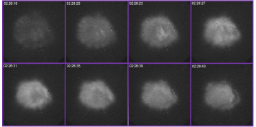
WW101 seems to think that clouds only form directly above where evaporation is actively occurring from the ground below. He seems to not understand water vapor transport and convection or the fact that convection can be quite explosive leading to rapid storm development in a matter of minutes. In fact, the entire life cycle of a typical thunderstorm, from initial formation to dissipation, averages a mere 30 minutes. GOES satellite images are downloaded every 30 minutes and acquired about every 26 minutes in Routine scan mode, every 7.5 minutes in Rapid Scan and in Super Rapid Scan there are 10 one-minute interval scans that are provided every half hour. WSR-88D radar in a severe weather Volume Coverage Pattern takes about 5 minutes to complete a full scan. A lot can happen in the life cycle of a thunderstorm during the time between radar or satellite image acquisition which can make it seem like a full blown mature storm suddenly came out of nowhere.External Quote:Again, evaporation is a slow process.
It is also - not at all - the source of any of the weather systems we regularly experience in this country, and this is an easily observable reality.
[..]
Evaporation is a slow process. Artificial Precipitation is not.
In Earth's natural system (which I have yet to determine how long ago ceased being responsible for our weather), you will never see a sudden explosion of superheated precipitation from a virtual pinpoint area.
[..]
blah, blah, blah
After some more radar loops he moves onto HAARP and other ionospheric heaters, which I'll pick up in the next post.
Reference links follow...
http://ww2010.atmos.uiuc.edu/(Gh)/guides/mtr/hyd/home.rxml
http://www.nwrfc.noaa.gov/info/water_cycle/hydrology.cgi
http://ww2010.atmos.uiuc.edu/(Gh)/guides/mtr/hyd/wind/wind.rxml
http://www.esrl.noaa.gov/psd/atmrivers/
http://www.class.ngdc.noaa.gov/data_available/goes/index.htm
Anyone interested in learning more about weather might consider perusing the National Weather Service's online school for weather.
http://www.srh.noaa.gov/srh/jetstream/index.htm
Last edited by a moderator: