Debunked: WeatherWar101 - Tornado Creation 201A

solrey

Senior Member.
Debunking the youtube video Tornado Creation 201A by WeatherWar101.

https://www.youtube.com/watch?v=wVX8f58IxY0

In my last video, I spoke about how (deliberately) difficult it is to get past radar images.

Like I said, there's good reason for this. If people had access to real historical radar data, this 'mystery' wouldn't be a mystery any more.
Content from External Source
That false claim is debunked HERE. In short, the NCDC makes it exceptionally easy for anyone to retrieve radar data spanning the entire lifetime of each radar station. Historical reflectivity mosaics for the Continental US are also available.

http://www.ncdc.noaa.gov/oa/radar/radardata.html

After a few minutes of a CONUS radar loop covering four days after tornadoes around Oklahoma City, WeatherWar101 attempts to explain cloud formation with an oversimplified version like something geared for children. In the process of trying to explain evaporation and cloud formation, he demonstrates zero understanding of the hydrologic cycle or water vapor transport in the atmosphere. The vast majority of water vapor in the atmosphere originates from the oceans and most of that water vapor is transported in what's known as Atmospheric Rivers. Nearly all of the rain that falls on the CONUS east of the Rockies evaporated from the Gulf of Mexico, the Caribbean or the Tropical Atlantic.

505,000 cubic kilometers of water evaporated from the world's oceans
72,000 cubic kilometers of water evaporated from land

Seven times the amount of water evaporates from the oceans as compared to land. The Earth's surface is 70% water after all.

http://www.eolss.net/Sample-Chapters/C07/E2-02-03-02.pdf

Again, evaporation is a slow process.
It is also - not at all - the source of any of the weather systems we regularly experience in this country, and this is an easily observable reality.
[..]
Evaporation is a slow process. Artificial Precipitation is not.
In Earth's natural system (which I have yet to determine how long ago ceased being responsible for our weather), you will never see a sudden explosion of superheated precipitation from a virtual pinpoint area.
[..]
blah, blah, blah
Content from External Source
WW101 seems to think that clouds only form directly above where evaporation is actively occurring from the ground below. He seems to not understand water vapor transport and convection or the fact that convection can be quite explosive leading to rapid storm development in a matter of minutes. In fact, the entire life cycle of a typical thunderstorm, from initial formation to dissipation, averages a mere 30 minutes. GOES satellite images are downloaded every 30 minutes and acquired about every 26 minutes in Routine scan mode, every 7.5 minutes in Rapid Scan and in Super Rapid Scan there are 10 one-minute interval scans that are provided every half hour. WSR-88D radar in a severe weather Volume Coverage Pattern takes about 5 minutes to complete a full scan. A lot can happen in the life cycle of a thunderstorm during the time between radar or satellite image acquisition which can make it seem like a full blown mature storm suddenly came out of nowhere.

After some more radar loops he moves onto HAARP and other ionospheric heaters, which I'll pick up in the next post.

Reference links follow...

http://ww2010.atmos.uiuc.edu/(Gh)/guides/mtr/hyd/home.rxml

http://www.nwrfc.noaa.gov/info/water_cycle/hydrology.cgi

http://ww2010.atmos.uiuc.edu/(Gh)/guides/mtr/hyd/wind/wind.rxml

http://www.esrl.noaa.gov/psd/atmrivers/

http://www.class.ngdc.noaa.gov/data_available/goes/index.htm

Anyone interested in learning more about weather might consider perusing the National Weather Service's online school for weather.

http://www.srh.noaa.gov/srh/jetstream/index.htm
 
Last edited by a moderator:
"After a few minutes of a CONUS radar loop covering four days after tornadoes around Oklahoma City, WeatherWar101 attempts to explain cloud formation with an oversimplified version like something geared for children."

That level of detail seems to work for all of his followers...some of the comments on that video are really sad - they are losing jobs, girlfriends, and are convinced today's weather is nothing like that of 15 years ago and that we (NWS) are crazy murderers......

"
Did I understand that the new CASA radar should help in quicker ID of severe storms?"

It should, as it is designed for near ground level scanning with the ability to rapidly adapt to changing conditions. Additionally, the WSR-88D Radar Operations Center has begun implementing new scanning techniques with recent software upgrades, one of which is already in use (AVSET -
Automated Volume Scan Evaluation and Termination) and one that is scheduled for implementation with the next software build (SAILS - Supplemental Adaptive Intra-Volume Low-Level Scan)

AVSET reads the radar return on each elevation above 5 degrees and terminates the current volume scan when the available return does not meet reflectivity strength and coverage thresholds. SAILS adds a supplemental 0.5° split cut scan to the existing severe weather Volume Coverage Patterns 12 and 212. SAILS will significantly increase the low-level scan update rate, especially when AVSET is active.

With all that said, there is a lot of new weather radar technology being introduced and this means there will potentially be less of WeatherWar's (and Dutchsinse's for that matter) "storms out of nowhere" appearing on radar.....


The saddest part to me is that we probably have people that will be unwilling to learn real science because it doesn't suit their world view. The girl asking if the producer of the video is married is hilarious.
 
If I understand their video correctly, are they implying the oft seen and thoroughly explained / debunked evening radar "blooms" are the "sudden explosions of super-heated moisture"? The "source" of moisture for all the storms? At about the 8:40 mark? That we are using the WSR-88 to generate plasma and that the plasma fields are what is visible on radar imagery?

Someone wants to know if this guy is single because he has "big brains"? Wow...

It is so incomprehensible to me the level of misrepresentation some of these people spew that just seems to get ate up as factual by all their followers so long as it sounds technical and fits their rhetoric.
 
They are starting installing CASA in the DFW area, but they are looking for private funds for it. To have something that useful and to have most of it sitting in a warehouse during a Texas spring, because of funding is not understandable to me.
 
Heh, I wonder what WeatherWar101 et al. will say if they ever find out about the next generation of weather radar currently undergoing field tests, the Phased Array. And of course the IRI at the HAARP facility, along with most ionospheric heaters, is a phased array.

http://www.nssl.noaa.gov/projects/parise/

http://www.nssl.noaa.gov/tools/radar/mpar/

My hope would be by the time those radars are deployed operationally on a large scale, this "haarp ring" nonsense and man made weather folly will be gone. But I doubt it.

And it would not matter that these new weather radars are significantly different. Dutchsinse has already accused some Naval phased array radars as being in on the whole cover up.

BTW - Weather War has another video coming out soon detailing the man made flooding in Canada. Can't wait.
 
If I understand their video correctly, are they implying the oft seen and thoroughly explained / debunked evening radar "blooms" are the "sudden explosions of super-heated moisture"? The "source" of moisture for all the storms? At about the 8:40 mark? That we are using the WSR-88 to generate plasma and that the plasma fields are what is visible on radar imagery?

Someone wants to know if this guy is single because he has "big brains"? Wow...

It is so incomprehensible to me the level of misrepresentation some of these people spew that just seems to get ate up as factual by all their followers so long as it sounds technical and fits their rhetoric.

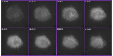
Starting at around the 17:00 mark he highlights (from dutchsinses wordpress site no less) an experiment conducted by the NRL that produced a spherical cloud of increased electron count and excitation in the ionosphere. Then at 19:30 he asks "Want to see what happens to you every night?" followed by a radar loop with perfectly normal night-time radar bloom which he titles "NEXRAD plasma generation" with an additional image of atomic oxygen green line emissions produced in the aforementioned NRL experiment which he titles "HAARP plasma generation".


Sequence of images of the glow plasma discharge produced with transmissions at the third electron gyro harmonic using the HAARP HF transmitter, Gakona, Alaska. The third harmonic artificial glow plasma clouds were obtained with HAARP using transmissions at 4.34 megahertz (MHz). The resonant frequency yielded green line (557.7 nanometer emission) with HF on November 12, 2012, between the times of 02:26:15 to 02:26:45 GMT.
Content from External Source
That is an optical image taken with a camera that filters out all wavelengths except 557.7 nm, the "green line" of atomic oxygen, which is responsible for the ubiquitous green auroras. Atomic oxygen is only stable and long-lived at altitudes above 90 - 100 km. What they did in the experiment was excite a tiny portion of the ionosphere directly above the antenna array shortly after sunset while there was still enough ionization present for the experiment to produce some barely visible air glow. They produced an electron density of at least 9X10^5 electrons per cubic centimeter. (For comparison, there are approximately 2X10^19 atoms in a grain of sand, which is about a cubic millimeter.) That level of ionization is squarely within the range of the normal average levels of the dayside ionosphere at around 300 km during solar maximum.


.
.
.

Radar bloom occurs...
When the sun goes down and the surface begins to cool, the change in refractive index in the lowest few (to several) hundred feet of the atmosphere tend to bend the radar beam toward the surface. This bending holds the radar beam near the surface for extended distances, where it encounters scatterers that would not normally be available above the boundary layer. These scatterers include insects, bats, aerosols, particulate matter, etc., and account for the increased radar return referred to as "radar bloom."
Content from External Source
Radar bloom, and most all ground clutter, is only visible on the lowest elevation slice of 0.5 deg. An easy way to identify ground clutter is to compare the base 0.5 deg. slice with higher elevation slices because ground clutter will normally not be visible on the higher elevation scans.

WSR-88D radar transmits on a wavelength of around 10 cm and band pass filters prevent all but that wavelength from getting through to the receiver. Microwaves also pass right through the quiet ionosphere, otherwise ground to satellite communications which operate on microwave frequencies would not be possible. WSR-88D radar units are not capable of receiving 557.7 nm wavelengths nor do the 10 cm wavelengths that they transmit reflect off the ionosphere to be detected as a return signal. There is a reason why UHF radar is used to analyze the effects of experiments in the ionosphere.

Only wavelengths shorter than 125 nm are capable of knocking electrons free to produce ionization while longer wavelengths, such as microwaves, can not produce ionization. Therefore it is impossible for WSR-88D radar, or any radio transmission, to ionize anything to produce plasma.

I'd like to see WeatherWar101's "big brain" explain in technical detail how ground clutter that's only visible on the lowest elevation radar scan has anything to do with 557.7 nm emissions from atomic oxygen originating at altitudes exceeding 100 km.

References:

http://www.nrl.navy.mil/media/news-...ificial-ionospheric-plasma-clouds-using-haarp

http://gbailey.staff.shef.ac.uk/researchoverview.html#ionosphere

http://www.ccmr.cornell.edu/education/ask/?quid=1268

http://www.accuweather.com/en/weather-blogs/weathermatrix/anomalies-radar-1/12444
 
Last edited by a moderator:
How long do you suppose it will take before this image, taken today, 6/27/13, of a shelf cloud approaching the Kansas City NWS office, will be scooped up by Dutch or WeatherWar or some other HAARP fanatic? I mean, such an ominous looking cloud right next to a WSR-88D...it's gotta be HAARP, right?? I was actually surprised to see there were no HAARP comments on their Facebook timeline photo from which I snagged this......

 
Last edited by a moderator:
Back
Top