1. "degrees per pixel" varies across the picture, it's higher near the center than at the edges because of how rectilinear projection works
Would this also be referring to lens distortion? If so, I agree that there is some minor distortion closer to the edges with a 55mm shot, though this appears to be minimal enough that it shouldn't affect the results significantly. So by "degrees per pixel", perhaps what I mean is an approximate degrees per pixel.
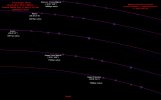
2. Distance to the circle matters. The equatorial circle looks like a straight line because we're in the middle of it—kinda how a coin looks straight when you view it sideways.
I'm not entirely clear on what you want to achieve: what is your input data, and what should the output be? Would you like to be able to draw star paths on any photograph?
Yes, you have it. The inputs are the camera focal length, camera sensor height + image height (which together determine the actual pixel size), and the star's declination. The output would be the pixel radius for those camera settings of the expected star trail, so that I can superimpose a star path circle on any photograph given those inputs.
Incidentally, I was playing around with this some more and found that dividing my previous prediction by the cosine of the complement of the star's declination (the declination compliment is apparently called the Codeclination) actually yields near exact results for every star trail picture I've taken. I'll post some examples later. I'm not sure of the theoretical validity of this, but it's an interesting find. Intuitively, this could make sense, because as the declination approaches 0, 1/cos(Codeclination) approaches infinity, hence a circle of infinite radius, or a straight line. As the declination approaches 90, 1/cos(Codeclination) approaches 1, which would explain why my previous method worked better closer to the poles but diverged closer to the celestial equator.
With this adjustment, my formula becomes:
Circle Radius in pixels = Codeclination / ( cos(Codeclination * π / 180) * (180/π) * atan(Sensor Height in mm / (Focal Length in mm * Image Pixel Height) ) )
(I'm curious as to how that'd help with FE debunking.)
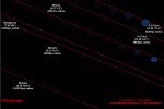
This part of the project involves comparing the shape of star trails on a spinning globe vs. the shape of star trails on a flat plane with a spinning dome. In the former, I believe I can say that every star trail should be a circle except for exactly on the celestial equator, which should appear to be a straight line. In the latter, star trails should be an oval or ellipse unless you're exactly at the north pole, because if you're away from the north pole, the stars will be getting further away from you as they go lower in the sky, and perspective should "squash" the circular trail.
As a matter of demonstration, I hope to overlay circles on star trail images of stars at various declinations. I realize math won't sway most flat earthers, but for my own completeness, I wanted to be able to back up the radius of these circles with actual theory. The thought being that it's one thing to overlay a circle on a star trail photo and be able to explain it away as "refraction" or something, and another to overlay a circle whose radius is actually predicted by an equation that only makes sense on a spinning globe.
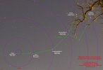
I also have a series of photographs taken by just spinning my camera around on the tripod at various angles from horizontal in a room with markings on the wall, demonstrating that the "star trails" of objects in the image also exactly match this approach. The axis of spin is vertical, but the camera is able to be angled from horizontal to vertical, allowing its field of view to simulate various latitudes on the globe. Whatever point is dead center would be the "declination" of that marking. I measured the "declination" of these markings using a rudimentary sextant attached to the camera, and can plug in the codeclination, sensor height, image height, and focal length to predict the circular paths with near exact accuracy. This should demonstrate that the paths things take from the perspective of a spinning observer exactly match what we observe in the star trails.
I'll have to think through whether dividing by the cosine of the codeclination actually makes theoretical sense, because my whole purpose is to back this up in theory. I'd ideally like to be able to derive this part of the equation somehow.