Flat Earth Theory Debunked by Short Flights (QF27 & QF28) From Australia to South America

It's nice to see that there are many more flights than expected and also from that many different airlines. Flat earthers basically will have to retreat to claiming that generally everybody is part of that grand conspiracy now. And that would include a lot of people...
Do you know what the current flat earth view on southern hemisphere flights is?

In the beginning they claimed they were all indirect, going via the northern hemisphere, and that flights were unbookable.

My sense is they moved on from that - maybe to claims about speed - and that now they don't really engage in a debate on SHF at all.

Not sure what I'm basing that on though, so could be totally wrong.
 
Do you know what the current flat earth view on southern hemisphere flights is?

Most still claim it's indirect and try to dismiss (of course without any shred of evidence whatsoever) the direct southern flights.

I remember one mentioned speed based claim which had wind always blowing conveniently as tailwind regardless which direction the plane goes.

At least you can be sure that it won't get boring with flat earthers lol
 
I have found the FE threads here to be really informative. FE was not something I ever really thought much about as it seemed so manifestly silly. And whilst it is profoundly daft it is a more or less harmless delusion (compared to things like alternative medicine and antivaxxers).

I have seen plenty of FE maps but never inspected them closely. At first glance they could be mistaken for a Transverse Mercator Projection that’s been fiddled with a bit. However, looking at them more closely they are frankly ridiculous and cannot, even with the most tortuous fiddling with the projections, bear any relation to the real world.
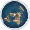
This is a standard FE map (I googled “flat earth map” and this was the first image in the results):

2C048977-4B69-4471-9840-17C7BD03B001.jpeg

Apart from the obvious horror story that is Australia the rest of it makes little sense. The shortest route UK/Australia is via Sweden - really. I also distinctly remember flying south east from London to Saudi Arabia rather than due east.

The distance between the tip of South Africa and South America looked ridiculous and seemed to make a mockery of plate tectonics. Apart from the fact that the tectonic plates cannot be fitted to this map the presence of the Mid Atlantic ridge automatically renders the map invalid.

In the picture above I drew in the MAR in red as best I could. From the bottom point the distance (all numbers are approximate, for obvious reasons) SAF/MAR is 3100km and SAF/SAM 3300km in the real world (measured using google maps distance tool).

As I can’t find a FE distance measuring tool I used the yellow line between north eastern Brazil and Africa as a yardstick. In the real world the two continents are 3000km apart.

Using this metric and straight lines (well, why not?) SAF/MAR increases from 3100km to about 9300Km. SAM/MAR increases from 3300km to over 13000km. (The white lines).

According to the FE map the shortest distance between the tips of the two continents the green line) is about 15,000km (and to fly that you would travel NE across Brazil) whereas in reality the great circle route is about 7,000km.

I tried to fit a few other aspects of plate tectonics to the FE map but my head exploded and I woke up down a rabbit hole.
 

Thanks for that Mick.

I knew I had seen one somewhere but used the wrong search description.

Pretty much supports my rough approximations (measuring distances on an iPad with a ruler!) 15,000 v 15142km SAM/SAF tip to tip.

Still, no matter how rough my estimates were how can a FE advocate reconcile the 2-3 times greater distances (and known routes) to reality.
 
The known tectonic plates are virtually impossible to reconcile with the flat earth map.

These are the plates:

60848591-F1EA-48C9-B754-F59BAF07BC35.gif

Here is half-baked effort at reconciliation:

EC989365-6D4D-401A-B07D-E5F839A82DB7.jpeg

I gave up as it is nigh on impossible. As with everything else in this nonsensical piece of fiction it becomes more orthogonal to reality the further you get away from the N Pole.

Obviously the entire community of geophysicists and geologists are in on the FE conspiracy as well. They will get their comeuppance when one of the continents falls off the edge of the planet.
 

Attachments

  • A5E59B11-668C-4574-BA4D-E2B6F5CA4508.jpeg
    A5E59B11-668C-4574-BA4D-E2B6F5CA4508.jpeg
    98.3 KB · Views: 450
Last edited:
The known tectonic plates are virtually impossible to reconcile with the flat earth map.

These are the plates:

60848591-F1EA-48C9-B754-F59BAF07BC35.gif
That illustration is problematic since there are three red lines at the right edge but only two on the left and the pacific and antarctic plate boundaries doesn't match up at the edges?
 
That’s the problem with trying to squeeze a sphere onto a flat plane.

Try this one, which is shifted away from the standard projection to centre on the Pacific.

19304CE9-D2A4-45A0-A0DD-45F0D08D9AEE.jpeg

Three plate boundaries on both sides.
 
An additional pointer to the total lack of credibility of the FE map (and thus the entire concept, because if the map is duff the concept is duff) can be found in submarine cables.

There are currently no submarine cables from southern S America to S Africa. (There are some to central west Africa). However Seaborn Networks are laying one due to go live in 2019.
(source: https://www.submarinecablemap.com/#/submarine-cable/sabr).

SABR (South Africa-Brazil geddit?) will run from Recife to Cape Town. The website doesn’t detail the length as it is not finished. However Google Maps gives it a distance of approx. 6100km. It might eventually be slightly longer as it has to have a few kinks to deal with submarine topography and flex to handle mid-ocean expansion.

The FE distance calculator gives the distance as approx. 12,000km so twice as long (give or take a few hundred kilometres either way). Luckily reality will help prevent the Project Director having to explain the discrepancy.

You can play this game with any submarine cable although it’s more fun in the Southern Hemisphere and over long distances.
 
An additional pointer to the total lack of credibility of the FE map (and thus the entire concept, because if the map is duff the concept is duff) can be found in submarine cables.
Unfortunately the argument is usually waved away because they will say they don't know what the map actually is, and all these things like flights, cables, and especially tectonic plates, are fake.

Best to focus on things they can actually check directly in the real world
 
OK.

I posted it here because whilst obviously not flights the cables are lines of communication where the shortest route between two points is imperative on cost grounds.
 
Johannesburg - Perth - Johannesburg
South African Airways
SA280/281 (SAA280/281)
Departs Johannesburg every day at 21.10
Departs Perth every day at 23.50

Sydney - Johannesburg - Sydney
Qantas
QF63/64 (QFA63/64)
Departs Sydney every day at 10.50
Departs Johannesburg every day at 19.10 (usually)

Johannesburg - Sao Paolo - Johannesburg
South African Airways
SA222/223 (SAA222/223)
Departs Johannesburg every day at 11.10 (sometimes more than one flight per day, also departing 21.35)
Departs Sao Paolo every day at 18.00 (ditto, with extra flight departing 23.35)

Auckland - Santiago - Auckland
LATAM Airlines
LA800/801
Departs Auckland every day at 18.10
Departs Santiago every day at 00.55

Sydney - Santiago - Sydney
Qantas
QF27/28
Departs Sydney Sunday, Tuesday, Wednesday, Friday at 12.30
Departs Santiago Sunday, Tuesday, Wednesday, Friday at 14.30

Mauritius - Perth - Mauritius
Air Mauritius
MK440/441
Departs Mauritius Tuesday and Saturday at 22.40
Departs Perth Wednesday and Sunday at 13.05

Auckland - Buenos Aires - Auckland
Air New Zealand
NZ30/31
Departs Auckland Sunday, Tuesday, Friday at 20.05
Departs Buenos Aires Sunday, Tuesday, Friday at 23.59

There may be differences in departure times on certain days, or other flights I'm not aware of. Corrections and additions welcome.

An additional southern hemisphere flight:

Luanda - Sao Paolo - Luanda
TAAG Angola Airlines
DT747/746
Departs Luanda every day except Tuesday and Thursday
Departs Sao Paolo every day except Wednesday and Friday

So I make that 84 direct flights every week, and more on occasion. Plus...
...several other (mostly) southern hemisphere flights, including:
  • Singapore-Johannesburg
  • Singapore-Mauritius
  • Mauritius-Hong Kong
  • Mauritius-Chengdu
  • Mauritius-Ghuangzhou
  • Mauritius-Shanghai
  • Hong Kong-Johannesburg
 
To anyone still following the polar circumnavigation flight in October.
https://www.overthepoles2018.com/

There is another YouTube producer with a channel name of GreaterSapien who has raised the volunteer funds needed to go on this trip. He has a lot of Flat Earth debunking videos on his channel and does a good job. Here's the video where he announced his intentions:


Source: https://www.youtube.com/watch?v=QE7b6Os3TlM

He of course intends to do what he can to prove this trip is real for his channel.

I have tried to contact him several times both in his comments section and privately, but I don't know if he has gotten any of my messages in the last week. Just trying to inform him of what I found out a few weeks ago about the whole flat earth issue as told to me by the administrator of the flight. He will have some limitations which he may not yet know about.

So far I have not seen a Flat Earther strive for the same. No surprise there.
 
Our own "black boxes" would of course be the ideal situation, but my understanding is these are plugged directly into the aircraft's systems. No Flat Earther would trust the aircraft's own black box information even if we would be allowed to download it after the flight.
I've heard that black box data on long flights doesn't cover the whole flight, because the recording capacity is only about 30 minutes long, so after the first 30 minutes gets recorded then minute 1 is replaced with minute 31, and then minute 2 is replaced with minute 32, etc. So that by the end of the flight only the last 30 minutes of data has been retained.
 
I've heard that black box data on long flights doesn't cover the whole flight, because the recording capacity is only about 30 minutes long, so after the first 30 minutes gets recorded then minute 1 is replaced with minute 31, and then minute 2 is replaced with minute 32, etc. So that by the end of the flight only the last 30 minutes of data has been retained.

Seems that this was true for tape, but not for digital:
Digital recorders have enough storage for 25 hours of flight data but only two hours of cockpit voice recording, which is recorded over itself in a loop. The CVRs track the crew's interactions with each other and air traffic control, but also background noise that can give vital clues to investigators. Earlier magnetic tape versions could only record 30 minutes of cockpit conversations and noise, which was also recorded in a loop.

http://mobile.abc.net.au/news/2014-03-26/black-box-flight-recorders/5343456
Content from External Source
 
Thanks for the replies, Clouds and Rory.

IMHO it's going to be totally RESISTED by flat-earthers every which way, to the point where any mention of the flight (after it's been completed) will be denounced unequivocally as a fake project. Satellite data showing tracking of the plane like by NORAD or GPS will be rejected as conspiracy nonsense. Some might revert to denying the existence of satellites (such as "because of the dome"), or that GPS is operated by way of the cell phone tower network, or that NORAD is just as fictional as NASA's photos.

Flat-earthers await their esteemed leadership to come out with the "party line" to which devout lemming followers all adhere, without thinking on their own. Therefore any consequential discussion must take place with such leaders, but keeping them accountable and honest is a big problem. None of them are going to give assent to questioning, any more than any of them are eager to step up to the plate by occupying a free seat on the plane.

Nonetheless, I hope the flight takes place as planned, and I hope there are scads of documentation, eyewitnesses, corroborating checkpoints, video footage, interview testimonies and physical evidence. It would be helpful if some passengers who embark on the first leg disembark at subsequent fuel stops, and other passengers embark to take their places. In that way, those who did not take the full round trip can be interviewed on location after disembarking at the various fuel stop locations amidst easily-identified surroundings, with which they are seen interacting so as to show that it's not a blue screen backdrop. I might be expecting too much, though.

Come to think of it, there are polar-orbiting satellites, that is, satellites that orbit the earth north-to-south such that they pass over the arctic region and the antarctic region alternatively. USA spy satellites passing over Russia (alias USSR) have mapped out scans along meridian lines all across Asia. I've seen flat-earthers try to deny that such a thing is possible. Some have gone from ambivalently accepting the principle of satellites to rejecting them entirely after having been faced with these north-south orbits, which are highly problematic against the flat-earthism fantasy world.

I recall seeing a cute explanation that tried to apply a "PacMan" scenario such that a satellite or aircraft that passes over the antarctic disappears on that side of the "flat" earth only to reappear on the diametrically opposite side, like PacMan could disappear on the left side of the screen only to reappear on the right side.
 
Last edited:
There are really only four cites that have flights near Antarctica:
  • Sydney, Australia
  • Auckland, New Zealand
  • Santiago, Chile
  • Johannesburg, South Africa.
Sydney and Auckland are fairly close, and so the three regions form a triangle around the South Pole.
ScreenFlow.gif

See also this practical demonstration, where the pilot of a Quanta jet videoed the sea ice, and then matched it with satellite images.
https://www.metabunk.org/a-flight-over-the-antarctic-sea-ice-from-chile-to-australia-qf28.t8235/
What is the source for this moving image, "22388" ? -- The one above that shows a triangle over the south pole with 3 points at Sydney/Auckland, Santiago and Johannesburg?

What are the 3 angles of this spherical triangle? They appear to be close to 90 degrees. But I don't know how to verify them, using the coordinates of these 3 cities. Or, whether to use Sidney or Auckland to get 3 90s.

An equilateral triangle on a flat plane always has three 60-degree angles (with a sum of 180 deg.), but on a sphere it's possible to have a triangle with three 90-degree angles (whose sum is 270 deg.). I'd like to know if these 3 cities lie on such a spherical equilateral triangle.

I understand that the limit of the sum of the 3 interior angles of a spherical equilateral triangle is 540 degrees, and the reason for that is, when the 3 great circle segment sides of such spherical triangle are extended to the point where they lie on the same great circle (such as the equator, for example), each of the interior angles becomes 180 degrees, and at that time you don't have a triangle anymore, but a circle; therefore, the sum of the 3 interior angles must be less than 540 degrees and not equal to 540 degrees. When the three interior angles are 90 degrees, their sum is 270, which is less than 540.

I realize that this post is starting to go off-topic but I'm not sure if starting a new thread is what I should do here. If you want to split this I wouldn't be surprised. But I hope you don't delete this post because I hope someone has an answer for my question.
 
Last edited:
To anyone still following the polar circumnavigation flight in October.
https://www.overthepoles2018.com/

There is another YouTube producer with a channel name of GreaterSapien who has raised the volunteer funds needed to go on this trip. He has a lot of Flat Earth debunking videos on his channel and does a good job.

https://www.kickstarter.com/projects/1282946600/pole-to-pole-circumnavigation-of-the-globe#

Here are the numbers:


First created by:
Jerry Williams
Oakland, CA

$17,542 pledged of $16,000 goal
275 backers
13 days to go
Content from External Source

Potential for being dismissed is right there on the Kickstarter page. The flight path on this projection:


It's just an oval!!! LOL!!!
 
Last edited:
Potential for being dismissed is right there on the Kickstarter page. The flight path on this projection:


It's just an oval!!! LOL!!!
It's just an oval -- HAHAHAHAHA

How about this one -- "You couldn't fly past the Ice Wall or you would smash into the DOME!"
 
I've heard that black box data on long flights doesn't cover the whole flight, because the recording capacity is only about 30 minutes long, so after the first 30 minutes gets recorded then minute 1 is replaced with minute 31, and then minute 2 is replaced with minute 32, etc. So that by the end of the flight only the last 30 minutes of data has been retained.

Someone could see if a PiAware ADS-B decoder would work in the passenger compartment of a plane. It might be screened from the TX antenna, but there could well be enough RF bouncing around at such close range. https://flightaware.com/adsb/piaware/

I don't even know whether mobile phones or laptops are allowed on planes these days, but obviously it should be looked into whether it would comply with regulations. Hmm.
 
Last edited:
I've used my cell phone's GPS reciever to track flights that I've been on. Using an app like Google My Tracks (now deprecated) gave me a full plot of the flight path as well as altitude and speed. The values were pretty accurate too compared to the on board moving map. It was a bit of a pain though because I had to keep the phone pretty much up against the window for it to catch the satellite signals so I didn't do it a lot. But since the phone can stay in Airplane Mode while you do it, no one on board should have a problem with it.
 
Future posts without proper documentation and quotes that follow site guidelines will be removed.

Perhaps you ought to follow this thread closer, or am I supposed to re-post everything I ever wrote on this thread each time I post something?
 
or am I supposed to re-post everything I ever wrote on this thread each time I post something?
In this case, yes. You are talking about specific people. If their buddies direct them to your post about them, it is ridiculous to expect them (or their buddies) to search the thread to see if you previously posted something confirming what you are saying.
 
In this case, yes. You are talking about specific people. If their buddies direct them to your post about them, it is ridiculous to expect them (or their buddies) to search the thread to see if you previously posted something confirming what you are saying.

Fine, it looks like without my input no one on this site would have known about this flight.

I brought my research, but it looks like you don't need me.

Deleting my account now.
 
here is an example of why paraphrasing is frowned upon. You said
11) [to answer my previous question] According to the fine print on the website the luggage limit is 36 pounds total in two bags maximum as carry-on only. No stowed luggage.

but the fine print page says
baggage.PNG

Source: https://drive.google.com/file/d/1bzX4UqtXmEG8Th3EqTXq4kAKJ9aSG8zQ/view


a small discrepancy, but it is still better to link to the fine print page and either type their quote or screen grab it like I did to show proof of what you are saying. It's not that difficult.
 
In this case, yes. You are talking about specific people. If their buddies direct them to your post about them, it is ridiculous to expect them (or their buddies) to search the thread to see if you previously posted something confirming what you are saying.

"Ridiculous" is a bit strong in this instance. Maybe there were less confrontational ways the point could have been made?

It will be a shame to lose someone who has made valuable contributions, and would no doubt do so in the future, because of a quibble over posting guidelines.
 
"Ridiculous" is a bit strong in this instance. Maybe there were less confrontational ways the point could have been made?
I wasn't calling him ridiculous. and my comment was not written in a confrontational tone. I was just explaining my reasoning. I can't think of a better way to word it, so perhaps you can suggest an alternative.
 
I wasn't calling him ridiculous. and my comment was not written in a confrontational tone. I was just explaining my reasoning. I can't think of a better way to word it, so perhaps you can suggest an alternative.

Not everything, no - but in this case, because you are talking about specific people, you should quote them again, or link to their words. If their buddies direct them to your post about them, it's pretty unlikely that they (or their buddies) will search the thread to see if you previously posted something confirming what you are saying.

Something like that.
 
Two Youtubers actually went on an Antarctic flight in January, Critical Think and Greater Sapien (mentioned above), though they are not Flat Earthers. This was the flight path (from CT's 2nd video), the flight originated and ended in Perth, Australia.
image.jpeg

Critical Think released three videos. The first was live-streamed on January 26th and shows him and Greater Sapien walking through Perth airport after disembarking the flight, giving their first impressions.
image.jpeg

Source: https://youtu.be/0Kbxo0jg86Y


Critical Think's second video, released two days later, shows footage from inside the plane, including some conversations with people from Curtin University, Perth, taking measurements on the flight. They don't think the Earth is flat, either. My first screenshot shows a magnetic needle in the foreground.
image.jpeg
image.jpeg

Source: https://youtu.be/iZEujQo_dZw


Critical Think's third video, released January 30th, shows various window shots of the Antarctic ocean and Antarctica.
image.jpeg image.jpeg

Source: https://youtu.be/acpxCvCLdkk


Greater Sapien has not yet released Antarctic footage, apart from this disjointed trailer announcing a yet unreleased video on his journey around the globe, of which the Antarctic flight was a part. (Screenshot 0:42)
image.jpeg

Source: https://youtu.be/O3ImKddDPak
 
Flight QF27 is often delayed over 30 minutes. That makes sense according to the Flat Earth map, since Santiago to Sydney is approximately 11,000 miles away. Planes fly at up to ~850mph. So 11,000 miles should take about 13 hours - that's your 12:25 +30min delay.


Last edited by a moderator:
Flight QF27 is often delayed over 30 minutes. That makes sense according to the Flat Earth map

Hi, and welcome to the forum. In all honesty, I'm reading your post as though you're writing sarcastically: is that what you're doing? I enjoy sarcasm a lot, but it's actually one of the guidelines here to avoid using it, since it can be confusing for some.

Also, for any lurkers, the distance between Santiago and Sydney on a hypothetical flat earth map is more like 26,000 miles; Mick made a really useful tool for measuring FE distances here:

https://www.metabunk.org/flat/

Cheers. :)
 
In addition, often is not the same as always, and you would also have to demonstrate that the plane is in transit during the delays.

You also have the far more significant problem of range and speed, since Qantas doesn't own any aircraft capable of either a range of 11,000 miles (let alone 26,000) or ~850 mph average cruising speed. The maximum cruising speed of their aircraft (which is necessarily greater than the average cruising speed) is 590 knots (1,093 km/h, 679 mph) with a Boeing 747-400ER, and the maximum range is 8,500 nautical miles (15,742 km, 9,782 mi) with a Boeing 787-9.

Source: https://www.aircraftcompare.com/aircraft/boeing-747-400er/
Source: https://www.aircraftcompare.com/aircraft/boeing-787-9/
 
Out of the last seven QFA27 flights, only one has had a duration close to 30 min over the scheduled travel time. That travel time also includes time on the ground taxiing, time for climbing to cruise altitude, and time to descend for landing. It's not like the aircraft doors close and then BAM you're instantaneously accelerated to maximum cruising speed.

qfa27.png
Source

Also, the 750 knot speed quoted is from a site of documented record ground speeds. Those are nowhere near the average cruise speed of these aircraft. That specific 750 knot record has a tail wind component of 217 knots pushing the aircraft to that speed.

commercial-jets-boeing-b747-400-750kts-wpcf_150x150.png
Source
 
Last edited:
Flight QF27 is often delayed over 30 minutes. That makes sense according to the Flat Earth map, since Santiago to Sydney is approximately 11,000 miles away. Planes fly at up to ~850mph. So 11,000 miles should take about 13 hours - that's your 12:25 +30min delay.


I just retired from flying the 747 for Qantas to places like Santiago. You are so far off the mark I can only conclude the post was an attempt at humour?
 
I've flown on the Perth - Mauritius flight which we took about 5 years ago.

Here's their route map.

As I've flown to Sydney many times can confirm we fly over land to Sydney and we flew over water all the way to Mauritius.

I've also flown to Dubai, Abu Dhabi and Doha en-route to various European destinations. We definitely didn't go that way. It takes about 3 hours longer to get to Dubai than Mauritius.

Fun fact - it's nearly an hour longer flying West from Perth, depending on time of year, compared to the return trip, due to the jetstream.

routemap_img.jpg
 
Last edited:
Back
Top