Bellingcat Analysis of Satellite Imagery Used In Russian Claims Against Ukraine

The Google Earth historical images provide some indirect evidence that the alleged "Buk" may have been moved out and then returned back between May 30 and July 2, 2014.
again if we believe google dates, looks like it moved between june 18th and july 1. This is june 18.
june18.PNG

although i still think somethings up with Google (i'm biased because i hate their invasion of privacy car).. the landscape doesnt change a bit between jul1 and july 20th but changes massively every other 2 week period. but again i'm biased)
 
right? it's not like anyone made it easy to find the bellingcat link. (thanks Herman! got it from one of your links). I see the issues now too.

But wouldnt it have been alot easier and less confusing to just show the truck thing (BUK thing?) never moved? well if we want to believe the google dates. :confused: ( i know i didnt do a great job with my lines..july 23 it looks like it moved but the angle is slightly different. Is a bit strange though the shadows of the trucks are EXACTLY the same on July1 and July 20.)

not moved.PNG
I was looking for possible differences in the vehicles' positions in this parking lot between the July 2 and July 21 (these are the true dates that Google Earth expressed in your local time). I can see some subtle differences, but they can be attributed to the slightly different viewing angles. I used the same technique that is usually used for watching stereo pairs - placed two similar images side-by-side and and looked at the left image with the left eye and the right image with the right eye. It works perfectly with "the spot the X differences between the two pictures" puzzles - all differences stand out at once. Not as well with real images, however, as there are minor distortions all over the place. Here is, for example, a side-by-side comparison of July 2 and May 30 images (enhanced):
Screen Shot 2015-06-07 at 12.47.38.png
There is a nice 3D effect, showing the vehicles, buildings and earth walls popping up from the ground, but there is not enough details for a definite conclusion regarding the positions of the vehicles that allegedly were taken out on an intermediate date. These appear to be very similar at given resolutions of the satellite images. Anyway, these similarities do not prove that the vehicles have not been moved, as they could have readily been returned to the same spots.

As for very similar shadows, they probably resulted from the satellite's Sun-synchronous orbit (a satellite in such an orbit passes over the same spot at about the same time of the day).
 
This discussion whould be in chit chat or general discussion. You are distracting from the topic.

The community has an interest in debunking period.

Yes, I acknowledge your opinion.

I'm sorry, didn't mean to hurt your feelings, I should know it's hurtful being pointed as biased
 
Anyway, these similarities do not prove that the vehicles have not been moved, as they could have readily been returned to the same spots
i used the lines in the parking lot. thats some precise driving to park it pretty much exactly the same!

but look at june 18 and july 1 (edit july 23 sorry getting my pix mixed up). i think thats the same pic...again, too strange to have it parked exact. so i dont know whats happening with those images.

I'm sorry, didn't mean to hurt your feelings, I should know it's hurtful being pointed as biased
you didnt hurt my feelings. i'm not biased. i have no clue what the russia/ukraine thing is all about.
 
Last edited:
you didnt hurt my feelings. i'm not biased. i have no clue what the russia/ukraine thing is all about.

Well, then it's my bad; I misinterpreted when you said "This discussion whould be in chit chat or general discussion. You are distracting from the topic. The community has an interest in debunking period." as a dismissal of my view that the choices of topics and efforts in debunking of this community seemed biased towards the western geopolitical point of view.
 
Well, then it's my bad; I misinterpreted when you said "This discussion whould be in chit chat or general discussion. You are distracting from the topic. The community has an interest in debunking period." as a dismissal of my view that the choices of topics and efforts in debunking of this community seemed biased towards the western geopolitical point of view.
its a dismissal of your view [being presented now] in this thread, i guess. if i was dismissing your view i wouldnt have told you where to stick it.
 
its a dismissal of your view [being presented now] in this thread, i guess. if i was dismissing your view i wouldnt have told you where to stick it.
Oh, the rules, the rules, of course.. How dare I to present a view where I felt it should be and not bother to open a thread?
 
i used the lines in the parking lot. thats some precise driving to park it pretty much exactly the same!
@TEEJ posted a photo in #16 without an explanation:

The largest available version is here.
This photo was used as a proof of that particular "Buk" having been put out of use. It is carefully framed to conceal the building behind and other vehicles on the site, but the number of concrete paving slabs between the "Buk" and the earth wall on the left appears to match the satellite images.
but look at june 18 and july 1 (edit july 23 sorry getting my pix mixed up). i think thats the same pic...again, too strange to have it parked exact. so i dont know whats happening with those images.
I did not get it. None of these images looks to me the same as one of the others. Could you post the screenshots?
 
I did not get it. None of these images looks to me the same as one of the others
the same as how the [buk] is parked in regards to the parkinglot lines. maybe july1 and july 20 (july2/july 21) is just a weird compression glitch. < oh nix that, i think its just the angle is the same in both these looking at the shed.

jj.PNG
 
Last edited:
Thank you, Trailspotter, for checking the publicly available evidence on the "July 14" and "July 17" image analysis done by Bellingcat. It takes guts to face the facts and accept the conclusions, before moving on to the next subject, and that is why I gave you a thumbs up on that post.

It sounds pathetic. As I have no agenda in this thread, I also have no problem with admitting that I overlooked the suitability of an area in the "July 17" image for comparison with GE historical images (area C in the Bellingcat report).

I see the most interesting aspect of this case in the opportunity to compare the satellite images from different sources. The Russian images probably were released first, and an unusually large amount of GE historical images of the same areas from DigitalGlobe came later. However, as the funding request in the OP suggests, it is not a full set of the available satellite images, but just a selection that discloses no movements of Ukrainian forces but helps to refute Russian timeline of images. But are all the images' dates in the Russian ministry's briefing are false? There was the (first) image of yet another area that the Bellingcat investigation did not touch:

It is dated July 14, 2014 and shows the area centred at 48°36’36″N, 39°13’55″E. Would you care to date it by comparison with GE historical images of this area (there are quite a lot for Summer 2014)?
I've already done my research, but I will hold my conclusions for now to avoid influencing your outcome ;)
 
Last edited:
the same as how the [buk] is parked in regards to the parkinglot lines. maybe july1 and july 20 (july2/july 21) is just a weird compression glitch. < oh nix that, i think its just the angle is the same in both these looking at the shed.

jj.PNG

Your first (left) image is for June 19. The satellite was slightly to the East, seeing the front wall of the blue building. In the second (right image) the satellite was to the West.
 
The Google Earth historical images provide some indirect evidence that the alleged "Buk" may have been moved out and then returned back between May 30 and July 2, 2014. In the above image, there is a track marked with green arrow that begins near the Buk's parking spot. It looks fresher in that image than in May 30 GE / Digital Globe image. Also, in July 2 image its extends in a new direction, compared to May 30 image:

[compare]
20140530track.jpg
20140702track.jpg
[/compare]

The shift is an artifact of the satellite look angle - in order to cover maximum area per orbit the DG family of satellites "look" left and right of the orbit nadir track. Note that the edge of the building also shifts. Google Earth is not designed to be mapping quality imagery, just illustrative imagery. In order to do an exact analysis the original data would need to be acquired from DG and full ortho-correction applied.
 
It sounds pathetic. As I have no agenda in this thread, I also have no problem with admitting that I overlooked the suitability of an area in the "July 17" image for comparison with GE historical images (area C in the Bellingcat report).

I see the most interesting aspect of this case in the opportunity to compare the satellite images from different sources. The Russian images probably were released first, and an unusually large amount of GE historical images of the same areas from DigitalGlobe came later. However, as the funding request in the OP suggests, it is not a full set of the available satellite images, but just a selection that discloses no movements of Ukrainian forces but helps to refute Russian timeline of images. But are all the images' dates in the Russian ministry's briefing are false? There was the (first) image of yet another area that the Bellingcat investigation did not touch:

It is dated July 14, 2014 and shows the area centred at 48°36’36″N, 39°13’55″E. Would you care to date it by comparison with GE historical images of this area (there are quite a lot for Summer 2014)?
I've already done my research, but I will hold my conclusions for now to avoid influencing your outcome ;)


Mmm. The impact craters on the building on the right suggests that this picture was taken after July 13 (GoogleEarth/DigitalGlobe shows no damage to that building on the July 13 image).
So this picture was taken between July 13 and July 21 (when the Russian Defense Ministry released it).
That does not exclude the July 14 date in the bullet, so the date may be correct.

However, there is something wrong with the time (11:31 according to the Russian Defense Ministry).

The shadows of the bushes and other features in the picture suggests a solar azimuth of something like 210 degrees.

When I enter 48°36’36″N, 39°13’55″E, and July 14, 2014, and Ukraine timezone 2 (UTC+2) +1 DST, into the NOAA solar calculator
http://www.esrl.noaa.gov/gmd/grad/solcalc/
I obtain a solar azimuth of only 150 deg for 11:31 am.

If I use Moscow time (timezone 3 (UTC+3) +1 DST) it gets worse, since solar azimuth should be no more than 128 deg at 11:31.

All of which is inconsistent with the shadows in the picture, which clearly suggest a solar azimuth west-of-south, at something like 210 deg.
 
Last edited:
Mmm. The impact craters on the building on the right suggests that this picture was taken after July 13 (GoogleEarth/DigitalGlobe shows no damage to that building on the July 13 image).
So this picture was taken between July 13 and July 21 (when the Russian Defense Ministry released it).
That does not exclude the July 14 date in the bullet, so the date may be correct.

However, there is something wrong with the time (11:31 according to the Russian Defense Ministry).

The shadows of the bushes and other features in the picture suggests a solar azimuth of something like 210 degrees.

When I enter 48°36’36″N, 39°13’55″E, and July 14, 2014, and Ukraine timezone 2 (UTC+2) +1 DST, into the NOAA solar calculator
http://www.esrl.noaa.gov/gmd/grad/solcalc/
I obtain a solar azimuth of only 150 deg for 11:31 am.

If I use Moscow time (timezone 3 (UTC+3) +1 DST) it gets worse, since solar azimuth should be no more than 128 deg at 11:31.

All of which is inconsistent with the shadows in the picture, which clearly suggest a solar azimuth west-of-south, at something like 210 deg.
Good. I have been comparing the tracks and paths on the ground and overlooked the shell damage to the building. However, I have come to the same conclusion - the image was taken after July 13.

As for the time inconsistency, it is clearly not 11:31 of Moscow time that in Summer 2014 was UTC+4h. The shadows are consistent with the time being 11:31 UTC, which could be a default time for satellite data. However, in the Russian briefing, the timeline of MH17 last minutes is clearly in Moscow time, so one would assume that the timestamps of satellite images are also in Moscow time.

I hypothesise that timestamp was altered deliberately to hinder the satellite identification. All Earth satellites are trackable; in theory, you can readily identify which satellite passed over the area at given time and took the picture. The capability of a spy satellite imaging equipment is a sensitive information that Russian military would not like to give away for nothing. It is true for any military, for example, NATO used the commercial (DigitalGlobe) images to publicise the movement of Russian units near the Ukrainian border rather than to use their own sensitive data. I think that these Russian satellite images may also have come from non-military sources, and the deliberate altering of date and time stamps was done to obscure the data sources. NATO or another agency (Ukrainian government?) responded to Russian bluff with commercially available images; I do not think that the release of a large amount of the satellite images of the conflict region was a charitable action by DigitalGlobe.

PS The www.n2yo.com site currently is tracking 17134 objects orbiting the Earth. It allows to track any of them around the globe, to predict the times and positions of satellites passing over the area of the user's choice and many other services. What it does not have (or I did not find this) is a playback facility that would allow to display the satellites passing over a given area at given date and time. This would be a great tool for an independent verification of date and time of satellite imagery. I believe that such a tool does exist, but probably is not in public domain. If someone knows a publicly or commercially available tool for this, I would appreciate a link.
 
I do not think that the release of a large amount of the satellite images of the conflict region was a charitable action by DigitalGlobe.
How so? Doesn't it help having claims by a major power open to proper scrutiny?
Or do you mean they only wanted to embarrass Russia?
Even so, if they were being untruthful they deserve to be 'embarrassed' by the truth.
Which is a charitable action in the sense of service to anti-bunk in my mind.
 
How so? Doesn't it help having claims by a major power open to proper scrutiny?
Or do you mean they only wanted to embarrass Russia?
Even so, if they were being untruthful they deserve to be 'embarrassed' by the truth.
Which is a charitable action in the sense of service to anti-bunk in my mind.
What I mean is that some agency could have paid DigitalGlobe for the release of these images into public domain, which is OK with me. DigitalGlobe is a business and its data are for sale. The Ukrainian government could have bought these images to refute Russian claims. I wonder if DigitalGlobe is allowed to sell its data to Russia, or there are restictions or embargo in place. The released images are just a selection of all commercially available images of the conflict region and its "juicy bits" are still unpublished. These probably include the images taken on the claimed dates of the Russian images and/or the images taken on the actual dates of these images. I very much doubt that the Russian ministry was 'embarrassed' by the truth. They knowingly bluffed with the false timestamps to get other major powers to show their data. The comparison with the released DigitalGlobe image shows that the dates on Russian images are the most likely false, but the images themselves are probably genuine. In some way, Belllingcat did Russians a favour: by independently dating Russian images, they have supported the original Russian claim of the Ukraine bearing full responsibility for MH17 downing - Ukrainian military deployed or intended to deploy "Buks" in the conflict region a month before the fatal incident, but issued no warning to civil airlines.
 
In some way, Belllingcat did Russians a favour: by independently dating Russian images, they have confirmed original Russian claim of the Ukraine bearing full responsibility for MH17 downing - Ukrainian military deployed or intended to deploy "Buks" in the conflict region a month before the fatal incident, but issued no warning to civil airlines.

And how would deploying them confirm Russian claims of Ukrainian fault?? Especially if all they did was "intend" to deploy them?

That doesn't follow.
 
#32 doesn't explain it at all as far as I can tell - it is claim that a buk launcher "may" have moved.......but the evidence presented by you there is vague and not very clear at all - the photos look identical to me whereas you claim there is some significant difference that escapes me entirely.

In any case, changing your wording to "supported" does not change my question - your premise simply does not support your conclusion.

At best, as far as I can see, if the Ukrainians DID move a Buk into the area then that raised the POSSIBILITY they shot the aircraft down - because then at least they have the required equipment.

If they INTENDED to move Buk systems into the area then that does not give them even that possibility.

It is just basic logic.

Firstly, I have made no conclusions in #32. I only tried to verify a hypothesis that the Buk was moved out some time in June 2014, based on the Bellingcat dating of the Russian "July 17" image, showing the Buk missing from its spot. The only indirect evidence I found by comparison of July 2 and May 30 GE historical images from DigitalGlobe was the presence of new vehicle tracks going south from the opening in the earth wall near the Buk's parking spot.

Secondly, I am not trying to defend the Russian claim, or to prove the Ukrainian guilt. What I said in #32 is the following:
"The Bellingcat analysis puts this date in June 2014, one month before the MH17 fatal shooting. This dating may seem to make these military movements irrelevant to the incident itself, but in a broader context they may have significant implications. At the least, the Russian satellite images cast doubts on the Ukrainian claims that their military never deployed antiaircraft weapons in the region of conflict and even put their "Buks" there out of use to prevent them falling into the rebels' hands. Which in turn presses the Russian's point: why Ukraine did not close the airspace for civil airliners well before the incident, if they knowingly deployed or intended to deploy such weapons."
In the blaming game between Russia and Ukraine, the first Russian accusation was that the Ukrainian government is fully responsible for the fatal incident because they knew in advance about the antiaircraft missiles being deployed in the region, but did not close airspace above it. That's all.
 
Last edited:
OK - thanks - this makes better sense to me:

In the blaming game between Russia and Ukraine, the first Russian accusation was that the Ukrainian government is fully responsible for the fatal incident because they knew in advance about the antiaircraft missiles being deployed in the region, but did not close airspace above it. That's all.
Content from External Source
Of course that claim in itself is nonsense in terms of who actually shot down the aircraft - it is just a shade away from victim blaming, so IMO isn't worth all that much effort.
 
All the cloud patterns match exactly, so this image directly from the DigitalGlobe catalog (id 1030010034CD4700, taken July 2, by the WoldView2 satellite) seems indeed to be the image that GoogleEarth used for their July 2 history of this area.

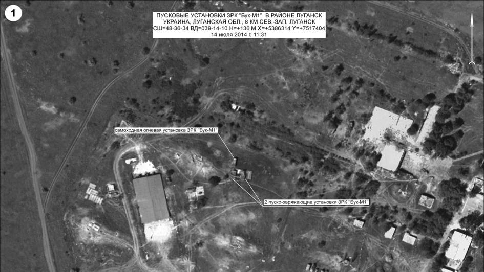
You can do the same thing for the other images (May 30, June 19) that Bellingcat used in their analysis that shows the Russian Defense Ministry's satellite pictures of airbase A-1428 were clearly taken in June and decidedly NOT on July 14 and July 17.

So, GoogleEarth history dates are correct, as verified with the DigitalGlobe's image catalogue.

Thus Bellincat is right, and the Russian Defense Ministry lied about the dates on their own satellite pictures.

Simple as that.

The low resolution preview of the DigitalGlobe catalog: id 1030010034CD4700, labeled 2014 July 2 and taken by the WoldView2 satellite shows not only the same cloud distribution as Google Earth at July 2 but indeed also the removed "woodland" at the left can be already seen.

Here's a slightly higher res preview (selected max. available resolution in popup) & cropped to the area of the airbase.
At the right is a crop from Google Earth July 2 of the same area and zoom level.

1030010034CD4700-preview-cropper-airbase.png 1030010034CD4700-googleearth-cropped-airbase.png

As for the metadata according to https://www.digitalglobe.com/sites/default/files/ISD_External.pdf

"Band Info: Pan_MS1_MS2":
"Pan - Sharpened" = Processed used to colorize imagery by fusing multispectral and panchromatic bands"
"Panchromatic" = A wide spectral band which is comprised of reflected light in the visible spectrum (blue, green, red and NIR). It is displayed as a black and white image. "
"MS1” = First 4 bands (Near-Infrared,Red,Green,Blue)
"MS2” = Second 4 bands (NIR2,RedEdge,Yellow,Coastal)

"Acq Date: Jul 2, 2014":
This is still of a problem, potentially. These image products can also be sets of images with different acquisition times, according to the mentioned guide and as well a cursory search on Google revealed. Which one would be used to date the whole product? The earliest of a range between 2014-07-02 and eg 2014-07-24? (Note: there's no 07-21 date in the product catalog, while Google Earth does show the date...and Bellingcat uses that date freely in their report without any verified metadata to back it up!)

It's a bit remarkable to me how people can conclude so many things without having one single original or source in hand! As we don't have the DigitalGlobe item yet with all the included files, structure and metadata at hand, is there any other way to know?

In my opinion the shown differences in the Bellingcat analyses of the images of the 2nd and the 21st of July are are highly questionable. With Google's 21st not even existing in the DigitalGlobe search results! And if the date of 2014-07-02 couldn't be verified either as actual photo acquisition date, there would be not much of a case left of the Bellingcat analysis of MoD picture #3 and #4.

So I retain my position that the whole analysis of satellite imagery appears to hinge on one particular dating of Google Earth and a product catalog search result of the image provider. There's not one piece of evidence yet given to illustrate that these package dates are precise while one used date at Bellingcat/Google is not traceable at all. And there's still some anecdotal evidence in the various product forums and image blogs warning from experience not to trust these single dates within applications. Enough reasons to remain skeptical!
 
Last edited:
@Herman Aven

How can you say there is no DigitalGlobe Image from 21st of July 2014, when there clearly is. And the cloud pattern over the donetzk airport is exactly the same as the one from Google Earth picture from the same date. Maybe you should check your filters for the DigitalGlobe catalogue.

Here is the ID for the pic from DigitalGlobe from 21st of July.
Catalog ID: 10300100343EC900 Acq Date: Jul 21, 2014 Center Lat/Long: 48,007°/37,795°
Avg Off Nadir Angle: 27° Avg Target Azimuth: 144° Spacecraft: WV02 Band Info: Pan_MS1_MS2


Are you going to reconsider your above posting, as it is heavily relying on not having a DG pic from July 21st?


This is still of a problem, potentially. These image products can also be sets of images with different acquisition times, according to the mentioned guide and as well a cursory search on Google revealed. Which one would be used to date the whole product?

What are you referring to here? The panchromatic, MS1, MS2, and pan-sharpened Worldview 2 imagery for a specific catalog ID are all collected at the same time. Pan sharpening is just a process to combine lower res multispectral imagery from MS1 RGB with higher res pan imagery to create a color image that appears higher resolution. Google Earth uses this imagery which is generated by the University of New Brunswick (UNB) "pansharp" algorithm.

A variety of pansharpening techniques take advantage of the complementary characteristics of spatial and spectral resolutions of the data [12]. Among them, component-substitution (CS) methods [13] are attractive because they are fast, easy to implement, and allow user’s expectations to be fulfilled. When exactly three MS bands are concerned, the most widely used CS fusion method is based on the intensity–hue–saturation (IHS) transformation. The spectral bands are resampled and coregistered to the Pan image before the IHS transformation is applied. The smooth intensity component I is substituted with the high-resolution Pan and transformed back to the spectral domain via the inverse IHS transformation.
Content from External Source
The pansharpening algorithm developed at the UNB, Canada, is based on CS. The least squares technique is utilized to reduce color distortion, by identifying the best fit between gray values of individual image bands and adjusting the contribution of the individual bands to the fusion result [27]. A set of statistic approaches is employed to automate the fusion process, by estimating the gray-value relationship between all the input bands and eliminating the influence of data set variation.
Content from External Source
Source: https://hal.archives-ouvertes.fr/hal-00177641/document
 
How can you say there is no DigitalGlobe Image from 21st of July 2014, when there clearly is. And the cloud pattern over the donetzk airport is exactly the same as the one from Google Earth picture from the same date. Maybe you should check your filters for the DigitalGlobe catalogue.

Hey, you're right! My own filters must have been wrong and I see Rob's original post where I looked as well has a date filter. So I hang my head in shame as I really thought I had double-triple-checked everything. Thank you for pointing this out in such a polite way.

Are you going to reconsider your above posting, as it is heavily relying on not having a DG pic from July 21st?

Not heavily but at least I have to withdraw the criticism of the July 21 picture use in the Bellingcat report. My main skepticism is based on experiences (my own and those of others) with exact dating in all kinds of scientific (image) databases and bulk catalogs, as well the very fact that we're still talking about analyzing illustrations attached to a PR statement. Which is not the type of thing that typically lends itself well for falsification. But it's interesting nevertheless.

But then again, now I've made that sloppy mistake, I'll have to do even more my best to get some hard information on those acquisition dates. But in a similar vein I still think Bellingcat should first have gotten all source images before publishing.

Here's the max. available resolution airbase crop from the preview of July 21 id 10300100343EC900.

10300100343EC900-preview-cropper-airbase.png
 
What are you referring to here? The panchromatic, MS1, MS2, and pan-sharpened Worldview 2 imagery for a specific catalog ID are all collected at the same time.

Hi David, I was not referring to imaging mode but to the way image products are being compiled and delivered. For example if more than one strip or "scene boundaries" are involved, then the imagery product will be divided "into multiple product components". This is different from product options like panchromatic, multispectral, or pan-sharpened. All according to the ISD documentation.

I've currently no way of determining what the mentioned product catalog "image product" really entails. Do they always contain single strips, one version only? From the ISD document (ch. 6 Image Metadata):

All other input images will be represented in the Image Metadata Description (IMD) and will appear in order of their acquisition date-timestamp with the oldest image appearing first. The date-timestamp of the oldest image will be used as part of the product filenames.
As far as I can see "Basic" is a single image product with one .IMD file per source image or strip and the multiple image products are Stereo, Standard, and Orthorectified. The last one often used for GIS. If any of this or any other process involved has any affect on the image product acquisition date, well, I just admit I don't know yet. But I'm learning!
 
Bellingcat obtained the 17th of July images from DigitalGlobe (this one from the GEO1 satellite) which confirm again, and without any doubt that the Russian Defense Ministry faked the dates on their July 14 and 17 satellite images

https://www.bellingcat.com/news/uk-and-europe/2015/06/12/july-17-imagery-mod-comparison/

I've been tracking and debunking Russian lies about MH17 and the Ukraine war in general for the past 10 months now, and there does not seem to be an end to it. Including the hypocritical allegations against Ukraine.

I've been disgusted by how the Russian Defense Ministry used their own radar images of the falling pieces of MH17, with 298 innocent people falling to their death, to falsely blame Ukraine for using SU-25 jets close to MH17.

I'm stunned by the constant stream of myths and lies (over 10 months) vented through the Russian media about MH17, including crudely faked images, hypocritically blaming Ukraine, while in FACT Bellingcat showed convincingly and uncontested, that the BUK that launched the missile that downed MH17 came from the 53rd BUK brigade in Kursk, Russia.

And I've been appalled by the satellite images from the Russian Defense Ministry accusing Ukraine of employing BUK missiles in the conflict zone, while in FACT they simply blatantly faked the dates on these images themselves.

And for the dozens (if not hundreds) of Russian apologists that troll Internet, making apologies for this behavior, as well as attacking anyone who presents the truth and debunks the verifiable lies, I have a question : Why are you supporting these lies ? What is at stake for you ? Is it your job ? Then why not find another one ? Is it your belief ? Then why not admit the facts ? Is it your life that is at stake ? Then how did you get into that situation ?

Either way, any apologetic stand for Russia's lies is an insult to reason, an insult to honesty and an insult to the 298 victims of this horrible crime.
 
Last edited:
All implicit ad hominem, emotion, politics and ideologies aside, we're all still waiting for publication of any obtained source material. Bellingcat claims to "use open source information" but all we have now are some croppings created by Adobe Photoshop according to the metadata and looking at least resaved once too many according to some quick ELA analysis. Of course that's only suspicious when it are Russians... Since no original data is available for research by at least some verified and accepted party, all we have here is guess work, the same old issues of trust and the comparing of various claims with some illustrations in a press release. Consider me underwhelmed but intrigued.

One slightly related question on a different analysis I have: what is the source of the image critiqued by Russia in Analysis of satellite imagery released on the Internet by the Security Service of Ukraine on July 30, 2014? They claim there it's from the American Key Hole but I wonder now if these might be WV2 as well. The Ukrainian Sich-1 or Sich-2 seem unlikely so did they purchase as well? And about the Russian satellite, I see references to "Persona 2 OR "Kosmos 2486" here. Not sure yet if this comes in handy for anyone.

Funny thing I found on that page is that the Russians already noticed the woodland problem in 2014 and states: "it is clearly visible that in the SBU’s image the circled tree belt has been deliberately distorted. The Russian satellite image does not have these distortions.".

The story gets murkier and murkier I've to say!
 
Last edited:
. Bellingcat claims to "use open source information" but all we have now are some croppings created by Adobe Photoshop according to the metadata and looking at least resaved once too many according to some quick ELA analysis.

That is arrant nonsense - indeed possibly an outright lie.

Bellingcat gives you specific and full instructions how you can source the original photos used here.
 
Funny thing I found on that page is that the Russians already noticed the woodland problem in 2014 and states: "it is clearly visible that in the SBU’s image the circled tree belt has been deliberately distorted. The Russian satellite image does not have these distortions.".

Are you suggesting that Digital Globe is also part of a conspiracy? The DG images also contradict the Russian imagery.
 
Are you suggesting that Digital Globe is also part of a conspiracy? The DG images also contradict the Russian imagery.

My main worry is that people, not hindered by any knowledge of remote sensing and image generation draw conclusion based on some visual anomaly. A bit like seeing faces or trees on Mars.

The reason I keep hammering on a complete set of source imagery is that the WV2 is multi-spectral and with an amazing 8 bands. But the capacities of the Russian satellite or algorithms we don't know. Bellingcat appears to show the "Pan - Sharpened" version, which is generated by algorithms but the Russian image probably is panchromatic and might contain a whole different level of for example the "near infrared" components. Combined with actual resolution differences and angles, this might create strong differences in apparent "vegetation" or relief. The more I look at the claimed differences, the more I suspect we're not even looking at removed "trees and bushes" but different (false) colorations and relief accents. Many features you can find at DG as well as the Russian picture. It would take quite an effort to show this. But the basic idea is Interpreting Optical Remote Sensing Images:

Several shades of grey can be identified for the vegetated areas, corresponding to different types of vegetation. Water mass (both the river and the sea) appear dark in the XS3 (near IR) band.​

The important discrepancies left remain the suddenly disappearing vehicles on the Russian pictures but it's not completely impossible they might have been moved in and back between 17th (after DG image) and the 21st. In other words, the case appears weak, the evidence hardly "open source" and near impossible to replicate since we have not enough specifications, metadata or just other samples from both satellites to compare. All basic precautions appear to be abandoned rather quickly and mostly speculation remains.
 
Last edited:
That is arrant nonsense - indeed possibly an outright lie.

Bellingcat gives you specific and full instructions how you can source the original photos used here.
You don't understand the concept, I'm afraid. Just telling people where to buy the license is not "open source". The images as published by Bellingcat are created in Adobe Photoshop and modified to an unknown degree. For me to verify their claim I need to order a copy myself but it's possible that there are resitriction in sharing the original files. I might as well ask the Russians for their originals but what's the use if I couldn't share them because of a gag order? Since I don't make claims and certain not claim "to use open source information to report on issues that are being ignored" (source) or "we used open source information, satellite imagery from Google Earth" (source) . Imagery which is not open-source btw but offered under a license without metadata in Google.

Just to make sure, open source as Wikipedia defines it as "free, unlimited access to content" and:

promotes a universal access via a free license to a product's design or blueprint,
 
You don't need a licence to use the images from Goggle Earth and the publicly available previews on Digital Earth.

I guess you're not actually interested in seeing the content.
 
You don't need a licence to use the images from Goggle Earth and the publicly available previews on Digital Earth.

But even if you did, it is still available to anyone willing to pay the licence fee.

I guess you're not actually interested in seeing the content.

I guess you just are not interested in investigating the claim of using "open source" and what that means in case of remote sensing products. Google Earth "grants you a non-exclusive, non-transferable license ... you may not use, access or allow others to use or access the Content in any manner not permitted under the Terms.. etc etc". And previews are not source products. If you ever had actually received a product from Digital Earth or other companies, you'd have noticed it comes with a bit more. Like I wrote there are eight multi-spectral bands and various products derived from that, as well information on the satellite position, timestamps, calibrations and much more. Open source means access to the source, not just accessing some product made out of source material.
 
I guess you just are not interested in investigating the claim of using "open source" and what that means in case of remote sensing products. Google Earth "grants you a non-exclusive, non-transferable license ... you may not use, access or allow others to use or access the Content in any manner not permitted under the Terms.. etc etc". And previews are not source products. If you ever had actually received a product from Digital Earth or other companies, you'd have noticed it comes with a bit more. Like I wrote there are eight multi-spectral bands and various products derived from that, as well information on the satellite position, timestamps, calibrations and much more. Open source means access to the source, not just accessing some product made out of source material.

That's being a tad pedantic. Bellingcat used data that is publicly accessible. That fact that additional data exists that you have to pay for is besides the point.
 
Just to be sure I went and followed the Bellingcat instructions again - and yet again the meta data at the link I provided IS open source - you can use the Bellingcat directions to find the dates of the pictures and compare them without paying a fee.

Here's the link again - you should actually try it before bursting into false outrage.
 
Last edited:
Herman, you are twisting and turning basic image interpretation by throwing in all kinds of strawmen. Panchromatic imagery is broadband covering RGB wavelengths with a single band. This is certainly what the MoD is showing. In the IR, vegetation would be bright because chlorophyll is highly reflective in the IR (google "red edge"), and that is not the case for the MoD imagery. The DG imagery is pan sharped visible natural color RGB because the vegetation is visibly green, it would be red if it was false color IR. So the comparison between the DG imagery and the MoD imagery by Bellingcat is reasonable to anyone with photo-interpretation experience and accompanied by "swipe" comparisons on their website. And what would access to the coastal, yellow, and red edge WV2 bands prove to you?

So, you seem to be arguing that unless you are provided raw multiband DG WV2 data from Bellingcat (which they can't because of licensing restrictions), the Russian jpegs are more reliable. And all Google Earth imagery is suspect because you don't believe it is accurately provenanced. You seem to argue that deference should always be given to the MoD imagery, because why?
 
Back
Top