• MH370 speculation has become excessive recently. Metabunk is not a forum for creating theories by speculation. It's a forum for examining claims, and seeing if they hold up. Please respect this and keep threads on-topic. There are many other forums where speculation is welcome.

MH370 Preliminary Report Released - Full Text and Files

In November, 2005, a Boeing 777-200LR broke the endurance record for commercial aircraft, flying eastward from Hong Kong to London.

Flight time: 22 hours, 42 minutes
Distance: 11,664nmi
Implied average ground speed: 513.8 knots
Source: http://news.airwise.com/story/view/1131662605.html

If only the ATSB had been around to patiently explain to those nitwits at Boeing how much more dramatically they could have increased their margin of victory simply by easing speed down into the LOW 300's...
 
I will try one more time to make the key point: endurance cannot be maximized by flying the (323kts GS, 30,000') path - in fact, the study I referenced in #3 suggests they are searching at a point on the Inmarsat arc least indicated by an endurance criterion!

Attached is the graph in #3, overlaid with an Excel chart I built to approximate it. Here are the fitted values, and key stats derived from them:


I am trying to focus on relative values - I don't want to get bogged down over whether 7 hours is the "right" baseline endurance, or whether "Mach-point-XY" is the "right" normal cruising speed - because this study was on an Airbus A320, and is not useful in absolute terms. But since it studied fuel cost on a large jet, at altitude, over an extended journey, I think it is HIGHLY relevant in relative terms.

Observations:
Endurance was maximized at 13% below normal cruising speed
Endurance at 34% below normal cruising speed was LESS THAN endurance at normal cruising speed
For MH370 to fly the "HIGHEST PROBABILITY" path in #1, it would need to fly at 34% below normal cruising speed

Any questions?

One question: Is it most common for aircraft "endurance" to be noted as time or distance?
 
One question: Is it most common for aircraft "endurance" to be noted as time or distance?

Good question. I've seen both, but my understanding is that proper usage of "endurance" is with respect to time, with "distance endurance" more properly described as "range".

range is optimized at just a small handful of knots below a jet's posted "typical cruising speed". My understanding is that the typical cruising speed is itself meant to maximize fuel economy (and thus range), adjusted only for a modest cost-index, or "time is money" factor, that suggests going slightly faster than maximum fuel efficiency is economically optimal.

endurance is optimized at an even slower speed, yes - but not as slow as the ATSB would have us believe. The study in #3 above suggests optimization at 13% below normal, and the endurance record in #41 suggests considerably less than that (though we should likely allow for a moderate tailwind correction, which might take it much closer to theoretical).
 
In November, 2005, a Boeing 777-200LR broke the endurance record for commercial aircraft, flying eastward from Hong Kong to London.

Flight time: 22 hours, 42 minutes
Distance: 11,664nmi
Implied average ground speed: 513.8 knots
Source: http://news.airwise.com/story/view/1131662605.html

If only the ATSB had been around to patiently explain to those nitwits at Boeing how much more dramatically they could have increased their margin of victory simply by easing speed down into the LOW 300's...

I am having difficulty understanding your point, here.

If it helps, perhaps you can get an understanding when you consider all of the many, many factors that affect the range and endurance of an airplane... total gross weight of course is foremost. (AND, weight decreases over time, as fuel is consumed). But, again the fuel is a given, based on the length of the flight that is planned. So then, the variable at time of takeoff is the payload.

'ZFW' (Zero Fuel Weight) is the figure used as part of weight & balance and performance calculations, in large jets. Self-explanatory I hope...we start with the basic Operating Weight (this is determined by weighing the airplane, then allowing for all "normal" equipment (which includes the basic crewmembers as well). That basic weight can be thought of as a "baseline", and is unique for every airplane. Now, we add to it the weights of any payload. And this establishes the 'ZFW'....which now is always the same, for a specific flight segment.

So of course, adding the fuel then results in your total Gross Weight, for any given flight segment at its beginning. Sorry if this is confusing, but it is a fact that with many variables, it does get complicated.

Also about the aerodynamics....for any combination of Gross Weight, altitude and Center of Gravity configuration, there is a "most efficient" Lift-over-Drag (coefficient of lift) and this also equates to aerodynamic drag, and thus affects fuel consumption rates, and thus range and endurance.

(As I said....it's complicated...)

PS: I might not be the bast, anymore, at explaining or "instructing" ( out of practice! ;) ). Member 'TWCobra' is also an airline pilot, and we also have "StrattMatt" who (I believe) is an active CFI (Certified Flight Instructor). So, hope I could help at least a little, and not make it more confusing?
 
I am having difficulty understanding your point, here.
WW, you are the best thing that could possibly have happened to my quest for accountability from these officials - if I can't convince you of the problem, how can I possibly convince an untrained member of the media or general public?

In my best attempt at pilot-speak: I ask anyone who is able and willing to please simulate the following two flight paths:

- each of EXACTLY 5 hours, 56 minutes flight time (2:15 to 8:11am UTC+8, March 8, 2014)
- each flying at constant KTAS, each at 30,000'
- each starting westbound at 6°10'56"n 97°35'8"e (waypoint VAMPI), already at cruising altitude & speed
- each with 239 passengers/crew + standard cargo on board
- each ending at low altitude (but not zero), to simulate presumed 8:19 ditch

Path1: end at 8:11am at 37°37'34"s 86°43'1"e: Inmarsat cross-point per middle of ORIGINAL NTSB estimate
Path2: end at 8:11am at 20°7'26"s 103°13'43"e: Inmarsat cross-point per MAR 28 REVISED ATSB estimate

For each path, you'll need to solve for the speed that gets you to each point at the precisely correct time. If you curl tightly around the tip of Indonesia, I recommend trying around 490 KTAS for Path1, and 325 KTAS for Path2. The object of the experiment is to see which path uses more fuel.

I get that fuel usage is sensitive to precision on all of the above factors, and on factors beyond those specified - please run the former through a range of feasible values, and model the latter as you see fit. All I ask is that you model them the same for each of the two paths each time.

The point of all my posts on this thread is a) Path1 should consistently use less fuel than Path2, yet b) the March 28 ATSB decision to move the search rests on the assumption that the opposite is true. (Even if Path2 uses slightly less fuel, the study in #3 suggests an intermediate path ("Path1.5?") uses less fuel than either extreme - and so we'd want to model THAT.) If I'm right, then the ATSB's analysis is either flat-out wrong (and they need to search elsewhere), or a flat-out lie (and they need to tell us the truth).

I eagerly await the simulation trial results.
 
In my best attempt at pilot-speak: I ask anyone who is able and willing to please simulate the following two flight paths:

What a challenge!!!

I am writing now to acknowledge this as a challenge, and also to say....absent the actual Boeing flight-test data and associated charts that this data produced? I really do not know how to proceed, to answer your queries.

Here is an example of what pilots need to know, in order simply to pass some (in this case, FAA written tests):

http://www.faa.gov/training_testing/testing/test_questions/media/atp.pdf

PLEASE NOTE: I took the ATP "written" test a LOOOOOOONG time ago!! (ca. 1977)

https://www.faa.gov/training_testing/testing/test_guides/media/FAA-G-8082-1J.pdf

Please also know that, in the airline "biz"....many OTHERS receive a lot of similar training, including DISPATCHERS....they have to know a LOT about Weight & Balance (and etc, as I explained previously)....and of course, nowadays there are numerous and wondrous computer programs which make ALL specialists' lives much easier.....still, though, when learning a skill, one MUST be taught (AND learn, and understand) the "basics"....

This thread is outside the scope. But, I hope you have seen just a "glimpse"?

(EDIT: And, I think the few links I found that are available online.....only scratch the surface of the HUGE amount of info that needs to be learned, and experienced. As I said...this Forum is simply not the place to learn the vast amount needed....).
 
In November, 2005, a Boeing 777-200LR broke the endurance record for commercial aircraft, flying eastward from Hong Kong to London.
Flight time: 22 hours, 42 minutes
Distance: 11,664nmi
Implied average ground speed: 513.8 knots
Source: http://news.airwise.com/story/view/1131662605.html
If only the ATSB had been around to patiently explain to those nitwits at Boeing how much more dramatically they could have increased their margin of victory simply by easing speed down into the LOW 300's..

Max Endurance is maximimum time aloft, typically achieved at a given altitude by flying at the minimum drag speed. When you go into a holding pattern, it is generally flown at Vmd (Min Drag) simply to burn the least amount of fuel while waiting for a further clearance.

Max Range is maximum distance flown for given fuel. It is slightly faster than Min drag speed. For the mathematically inclined they are described here. Airliners generally cruise faster than the Max range speed in order to reduce other costs such as maintenance and crew costs but if they need to save some fuel, say to meet a meteorological forecast requirement, they will reduce speed in order to do this.

For each path, you'll need to solve for the speed that gets you to each point at the precisely correct time. If you curl tightly around the tip of Indonesia, I recommend trying around 490 KTAS for Path1, and 325 KTAS for Path2. The object of the experiment is to see which path uses more fuel

The missing data here is altitude. Without knowing the altitude the aircraft flew, any simulation would be meaningless.
 
The missing data here is altitude. Without knowing the altitude the aircraft flew, any simulation would be meaningless.

Maybe we can attack this from a different angle: the study in #3 shows dramatic fuel efficiency REDUCTION as cruising speed is reduced. Why is that? I had assumed that, as speed reduces, the "natural" altitude at which the plane can comfortably fly must necessarily reduce. This is consistent with everything I thought I knew about wing camber: faster speed = greater lift = higher altitude at which lift and gravity are at equilibrium. If so, then the speed (& weight) should to within a reasonably tight margin determine the altitude.

But maybe there's a DIFFERENT reason fuel efficiency erodes...?
 
The missing data here is altitude. Without knowing the altitude the aircraft flew, any simulation would be meaningless.
In the absence of hard data, agree we'd need to try running the sim at a range of feasible altitudes, for now. If the new path uses more fuel in ALL of them (or NONE of them), then I'd have my answer.
 
Maybe we can attack this from a different angle: the study in #3 shows dramatic fuel efficiency REDUCTION as cruising speed is reduced. Why is that? I had assumed that, as speed reduces, the "natural" altitude at which the plane can comfortably fly must necessarily reduce. This is consistent with everything I thought I knew about wing camber: faster speed = greater lift = higher altitude at which lift and gravity are at equilibrium. If so, then the speed (& weight) should to within a reasonably tight margin determine the altitude.
But maybe there's a DIFFERENT reason fuel efficiency erodes...?

Actually the attitude increases - you get lift from speed and angle of attack (put simplistically) - if you reduce speed you have to increase the angle of the attack of the wing if you want to maintain altitude, which means it presents a larger frontal area to airflow, and creates more drag.

My instructor colleague was explaining this to me a week or so ago - you can cruise in a Piper Tomahawk PA-28 at about 75% power, but you need 80-85% if you drop the speed by 20 knots and try to maintain the same altitude.

Actually.. do we KNOW how much of a reduction in speed there was by chance? Not asking you per-sey Mike, just asking in general.. your post kinda triggered somethin in the old brain box, so before I open my mouth I wanna make sure I have all the facts.
 
In the absence of hard data, agree we'd need to try running the sim at a range of feasible altitudes, for now. If the new path uses more fuel in ALL of them (or NONE of them), then I'd have my answer.

We would need the weight of the aircraft at takeoff, the fuel on board and some comprehensive data regarding fuel flows at different weights, altitudes and speeds. Remember that the fuel flow at all altitudes/speeds decreases as the fuel is burnt off. You can break it down into hourly averages, but you need to know where to start.
 
One of the frustrations of this investigation is the paucity of information being released. The NTSB and even the French BEA in their various recent investigations were much more forthcoming with information about possible directions they were going at this stage. My concern from the beginning is the conflict of interest here. Malaysian Airlines is to all intents and purposes owned by the Malaysian government.

The ATSB is also not immune from political intrigue. The Australian government is well aware of the sensitivities of dealing with governments in Asia.

My feeling is that sensitive information is being withheld. I can't prove that but it is the nature of the beast.
 
....But look at the changing SLOPE of the graph. It means that, for anything SLOWER than 20% below optimum, fuel burn per unit time is HIGHER than at optimum.

Meaning MH370 would have preserved fuel longer flying at 490kt than at its "MOST PROBABLE" speed of 325kt.

This time, folks, I'm afraid it is the "official theory" that needs to be debunked.

Totally agree... The route published by Malaysia in the preliminary report does not stack up on several levels.

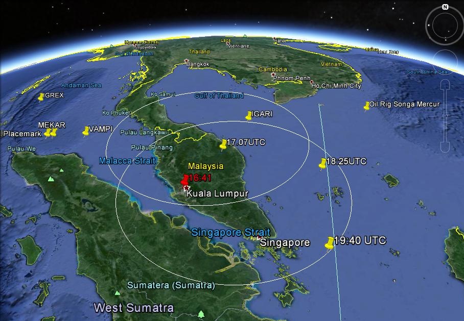
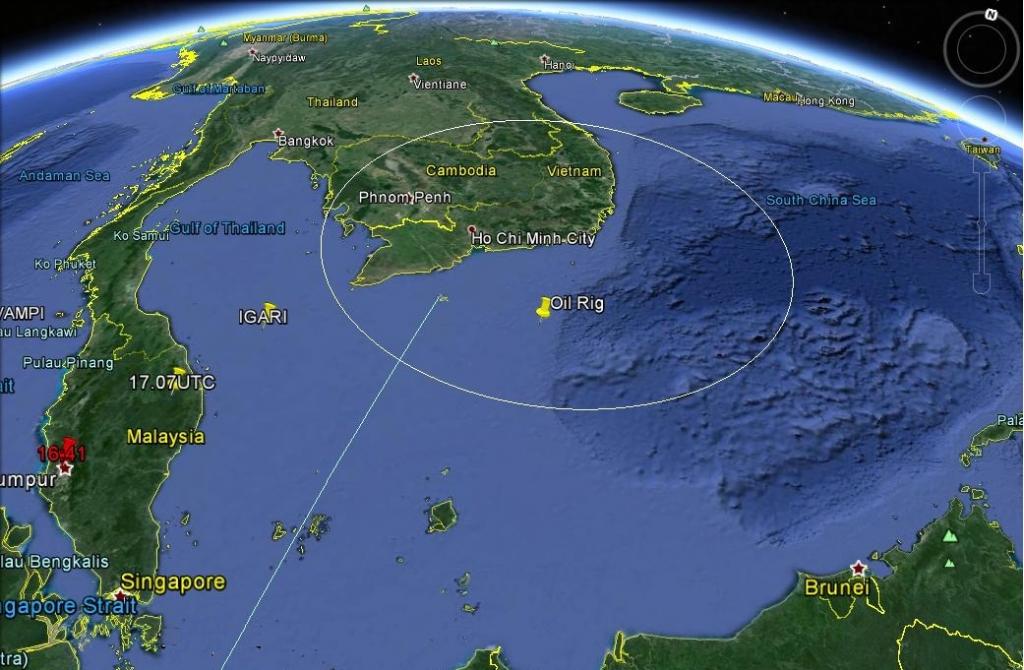
This is the military radar coverage by Thales Ratheyon GM400 radar east of the Malay peninsula. Neither of these radar stations are reported to have seen MH370 fly back from IGARI. The Malaysian Government insists MH370 dropped to 5,000ft to avoid radar and flew around like a fighter plane, including penetrating the 7,000ft+ Titiwangsa Range in darkness flying nap of the earth.


Then there is the issue that after 17:30 UTC JAL750 established line of sight VHF contact with MH370. JAL750's captain said he spoke with co-pilot Fariq Abdul Hamid and all appeared normal. At 17:31 UTC JAL750 was at 32,000ft flying north east from Ho Chi Minh (11.55N, 108.43E). This position was 398nm from IGARI.

The radar horizon from 32,000ft to another aircraft at 5,000ft is 306nm. This means if MH370 dived to 5,000ft at IGARI and flew west then it would never have communicated with JAL750, but not only did it speak to JAL750, but also with MH088 which was even further north over Vietnam.

This is the VHF radius from JAL750 to another aircraft at 5,000ft:


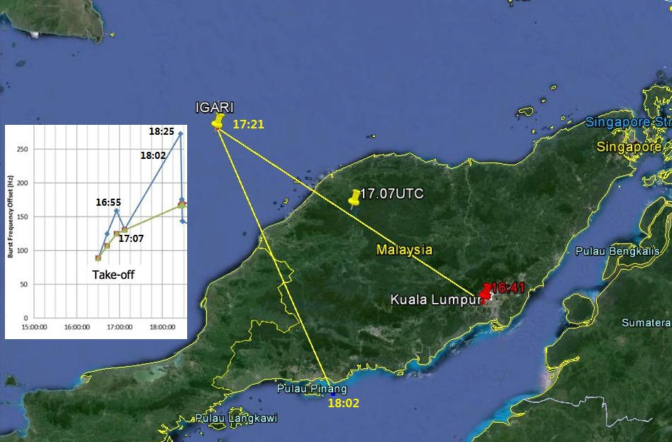
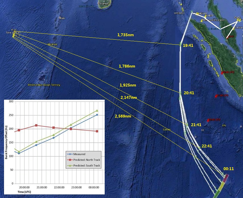
Whilst the Burst Offset Frequency chart displays velocity as a frequency, the frequency also tells us if that is towards (increase) or away from the satellite (decrease).

Because INMARSAT's position was west of MH370 it can also be described simplistically that any decrease is east away from INMARSAT and any increase is west towards INMARSAT.

The biggest inconsistency is that until about 17:24 UTC MH370 was observed by radar/transponder returns flying east when the BOF chart suggested it was flying west. If the BOF chart is to be believed MH370 should have flown west from its position at 17:07 UTC, not from IGARI. The BOF chart data does not match radar data.


Another issue is that originally it was said MH370 flew IGARI-VAMPI-GIVAL-IGREX.

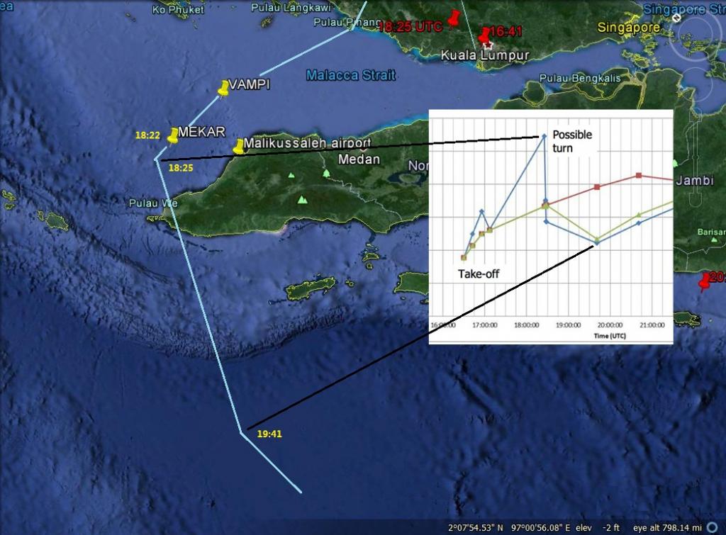
When relatives leaked Butterworth radar imagery from a conference at Beijing only showing a target flying from Penang to VAMPI to MEKAR the Malaysian government quietly shifted the goalposts and adapted the story to the new route claim.

As that route exits the Straits between 18:25 and 17:41 UTC it flies ostensibly SW diagonally towards the satellite yet the BOF chart shows the opposite, a target flying away from the satellite.


The orientation of the above image is looking from the west.

Then after 17:41 UTC is the biggest con job:


In the final part from 19:41 to 00:11 UTC the BOF chart shows constant frequency increase as if MH370 flew towards the satellite, therefore if anything MH370 should have flown into the middle of the Indian Ocean. Instead the Malaysian Government insists it flew the opposite direction.

Whilst I have no difficulty accepting that the southern arc distance was an accurate figure, the whole story of how the BOF chart plot directed searchers to the location where Ocean Shield heard ULB pings is a fallacy.

Whilst I do give credence to the Exner BOF chart the official position does not accept Mike Exner's revised chart.
 
Last edited:
Totally agree... The route published by Malaysia in the preliminary report does not stack up on several levels.

This is the military radar coverage by Thales Ratheyon GM400 radar east of the Malay peninsula. Neither of these radar stations are reported to have seen MH370 fly back from IGARI. The Malaysian Government insists MH370 dropped to 5,000ft to avoid radar and flew around like a fighter plane, including penetrating the 7,000ft+ Titiwangsa Range in darkness flying nap of the earth.


Then there is the issue that after 17:30 UTC JAL750 established line of sight VHF contact with MH370. JAL750's captain said he spoke with co-pilot Fariq Abdul Hamid and all appeared normal. At 17:31 UTC JAL750 was at 32,000ft flying north east from Ho Chi Minh (11.55N, 108.43E). This position was 398nm from IGARI.

The radar horizon from 32,000ft to another aircraft at 5,000ft is 306nm. This means if MH370 dived to 5,000ft at IGARI and flew west then it would never have communicated with JAL750, but not only did it speak to JAL750, but also with MH088 which was even further north over Vietnam.

This is the VHF radius from JAL750 to another aircraft at 5,000ft:


Whilst the Burst Offset Frequency chart displays velocity as a frequency, the frequency also tells us if that is towards (increase) or away from the satellite (decrease).

Because INMARSAT's position was west of MH370 it can also be described simplistically that any decrease is east away from INMARSAT and any increase is west towards INMARSAT.

The biggest inconsistency is that until about 17:24 UTC MH370 was observed by radar/transponder returns flying east when the BOF chart suggested it was flying west. If the BOF chart is to be believed MH370 should have flown west from its position at 17:07 UTC, not from IGARI. The BOF chart data does not match radar data.


Another issue is that originally it was said MH370 flew IGARI-VAMPI-GIVAL-IGREX.

When relatives leaked Butterworth radar imagery from a conference at Beijing only showing a target flying from Penang to VAMPI to MEKAR the Malaysian government quietly shifted the goalposts and adapted the story to the new route claim.

As that route exits the Straits between 18:25 and 17:41 UTC it flies ostensibly SW diagonally towards the satellite yet the BOF chart shows the opposite, a target flying away from the satellite.


The orientation of the above image is looking from the west.

Then after 17:41 UTC is the biggest con job:


In the final part from 19:41 to 00:11 UTC the BOF chart shows constant frequency increase as if MH370 flew towards the satellite, therefore if anything MH370 should have flown into the middle of the Indian Ocean. Instead the Malaysian Government insists it flew the opposite direction.

Whilst I have no difficulty accepting that the southern arc distance was an accurate figure, the whole story of how the BOF chart plot directed searchers to the location where Ocean Shield heard ULB pings is a fallacy.

Whilst I do give credence to the Exner BOF chart the official position does not accept Mike Exner's revised chart.
I honestly think Simon makes great arguments, and while I didn't see eye to eye with him in the past, he takes the time to put together well thought out and constructive and rational arguments. I also think he might be on to something here as well.
 
Thanks Jason,

I am puzzled by one thing. I have read in Chinese press releases from 8th March that a distress call was picked up in U-Tapao Thailand from MH370 in which the stricken crew wanted to make an emergency landing because their "cabin faced disintegration."

China reports that the US Embassy provided a tape recording of that distress call to Malaysia. Since then the NSA has invoked Executive order #13526 to prevent disclosure of information about MH370 under the FOIA to a US attorney.

VTBU-Rayong was not within reception range of either MH088 (flying at 39,000 over Vietnam), or BITOD, therefore if one believes there was a distress call picked up by the US navy it was not picked up at VTBU Rayong, but picked up by USN intelligence assets over the South China Sea.

That is the reason Executive Order #13526 was invoked to prevent disclosure of intelligence assets off the coast of Vietnam.

Do you have a link to any of this.
 
Thanks Jason,

I am puzzled by one thing. I have read in Chinese press releases from 8th March that a distress call was picked up in U-Tapao Thailand from MH370 in which the stricken crew wanted to make an emergency landing because their "cabin faced disintegration."

China reports that the US Embassy provided a tape recording of that distress call to Malaysia. Since then the NSA has invoked Executive order #13526 to prevent disclosure of information about MH370 under the FOIA to a US attorney.

There are various reports around the 'net about this that it was reported in the China Times - eg here on Reddit

However there a search for U-Tapao (& various spellings) on the English edition of the china times gives no result - the place never features at all.

there is an article in the Chinese edition, but when I try to google-translate it it instantly flicks to another page - if anyone can figure out how to hold that translation long enough to read it i'd be grateful....
 
Thanks Jason,

I am puzzled by one thing. I have read in Chinese press releases from 8th March that a distress call was picked up in U-Tapao Thailand from MH370 in which the stricken crew wanted to make an emergency landing because their "cabin faced disintegration."

China reports that the US Embassy provided a tape recording of that distress call to Malaysia. Since then the NSA has invoked Executive order #13526 to prevent disclosure of information about MH370 under the FOIA to a US attorney.

VTBU-Rayong was not within reception range of either MH088 (flying at 39,000 over Vietnam), or BITOD, therefore if one believes there was a distress call picked up by the US navy it was not picked up at VTBU Rayong, but picked up by USN intelligence assets over the South China Sea.

That is the reason Executive Order #13526 was invoked to prevent disclosure of intelligence assets off the coast of Vietnam.
I agree with Landru, a link would help out alot, and the china times link you provided earlier needs a source because it seems like they are the only one reporting that
 
https://peoplestrustmalaysia.wordpr...ess-call-was-sent-from-the-plane-china-times/

#MH370 – SOS distress call was sent from the plane – China Times
Posted on May 7, 2014


Thanks to Simon (NZ) for the links.

“…all parties involved in assisting the Malaysian government have remained “very tight-lipped about what is going on”. – Aviation expert Clive Irving

The China Times reported on 8th March that MH370 made a distress call that they would make an immediate landing because the “cabin faced disintegration.”
.
The distress call was recorded by a US Navy listening post VTBU-Rayong at U-Tapao, Thailand. The US Embassy handed over tape recordings to the Malaysian Government but your Government will not mention the distress call in the preliminary accident report.

http://www.chinatimes.com/realtimenews/20140308003502-260401
.
Google translate:
.
The U.S. military saidthe debrisfoundmoreoilreceivedSOSsignals
Malaysia Airlinespassenger planelost contact, Malaysia, China, Vietnam, the Philippines, Indonesia and other five countriesinvolved insearch and rescue.Malaysia,Vietnam,flewlockmayhavelost contact withthe seasearch.According to the U.S.Cable News Network(CNN)reported thatinstant, one of Vietnamrescueaircrafthave discoveredoiland debrisin Malaysia andVietnamat the junction ofthe sea.


In addition, the U.S. Embassy said the 2:43 U.S. military bases stationed in Thailand U-Tapao SOS signal was listening to some of Malaysia Airlines Flight MH370 emergency call, said the aircraft cabin facing disintegration driver call, they want a forced landing .U.S. troops are currently stationed in Thailand, Malaysia has been providing this signal.
Content from External Source
Is this by any chance from you Simon? Anyway it has the press release translation in it from China Times with the link to China Times.
 
But then I found this which states that a lab did test of the oil slick and they found out that it was from a ship.

http://www.thewire.com/global/2014/03/heres-every-mh370-theory-weve-considered-so-far/359355/
Within 24 hours of the plane’s disappearance, Vietnamese officials reported that they spotted an oil slick on the water in the general vicinity of where the plane was last spotted. According to the Civil Aviation Administration of Vietnam’s Director Lai Xuan Tanh:
An AN26 aircraft of the Vietnam Navy has discovered an oil slick about 20 kilometers in the search area, which is suspected of being a crashed Boeing aircraft -- we have announced that information to Singapore and Malaysia and we continue the search.

The assumption of most investigators at that point, was that MH370 went down soon after losing contact with ground control, leaking fuel as it crashed into the water, though they still had no guesses as to what caused the malfunction.

In less than a day, however, that theory was dismissed, when lab results showed that the fuel causing the oil slick actually came from a ship, and could not have left there by a plane.
Content from External Source
 
Thanks Jason,

I am puzzled by one thing. I have read in Chinese press releases from 8th March that a distress call was picked up in U-Tapao Thailand from MH370 in which the stricken crew wanted to make an emergency landing because their "cabin faced disintegration."

China reports that the US Embassy provided a tape recording of that distress call to Malaysia. Since then the NSA has invoked Executive order #13526 to prevent disclosure of information about MH370 under the FOIA to a US attorney.

VTBU-Rayong was not within reception range of either MH088 (flying at 39,000 over Vietnam), or BITOD, therefore if one believes there was a distress call picked up by the US navy it was not picked up at VTBU Rayong, but picked up by USN intelligence assets over the South China Sea.

That is the reason Executive Order #13526 was invoked to prevent disclosure of intelligence assets off the coast of Vietnam.
Ok so now that the we've concluded the oil slick was from a ship, that leaves the "tape recording" of a distress call from MH370 to Malaysia. I wonder if there is some way of finding this recording, or the original source for this. Now just because the oil slick off the coast of Vietnam turned out to be from a ship it doesn't discount what Simon is saying
 
Ok so now that the we've concluded the oil slick was from a ship, that leaves the "tape recording" of a distress call from MH370 to Malaysia. I wonder if there is some way of finding this recording, or the original source for this. Now just because the oil slick off the coast of Vietnam turned out to be from a ship it doesn't discount what Simon is saying
There is no credible evidence that the tape recording exists.
 
Do you have a link to any of this.

MH370's distress call:

http://www.chinatimes.com/realtimenews/20140308003502-260401


越發現油污碎片 美軍稱收到SOS信號

2014年03月08日 20:25

.... 另外,美國駐華大使館稱,淩晨2點43分美軍駐紮在泰國烏塔堡軍事基地曾監聽到一段馬來西亞航空公司MH370航班緊急呼叫的SOS信號,客機駕駛員呼叫稱機艙面臨解體,他們要迫降。目前駐泰美軍已向馬來西亞方面提供這段信號。
Content from External Source
Google translation:


In addition, the U.S. Embassy said the 2:43 U.S. military bases stationed in Thailand U-Tapao SOS signal was listening to some of Malaysia Airlines Flight MH370 emergency call, said the aircraft cabin facing disintegration driver call, they want a forced landing . U.S. troops are currently stationed in Thailand, Malaysia has been providing this signal.
Content from External Source


Executive Order #13526:

http://beforeitsnews.com/conspiracy...he-rest-of-the-world-doesnt-know-2462386.html

Whilst I do not support the conspiracy theory expounded by Orly Taitz, nor that of Lt. General McInerney, the latter's reference on FOX TV that a distress call was heard from MH370 corroborates the China Times report


Press Relese:
March 19, 2014.

Law offices of Dr. Orly Taitz, ESQ

Public is urged to call the US Congress and demand an immediate investigation of reports by Lt General McInerney, who stated that US obtained the radio communications from missing MH370 and it is in Pakistan, on the air base controlled by Taliban

Yesterday, on 03.18.2014, Lt. General McInerney appeared on Hannity show on FOX and stated that US “vacuum cleaners”, meaning NSA and CIA, received radio communications from the missing MH 370 flight which showed that the plane landed on a Taliban controlled base in Western Pakistan.

Mc Inerney urged the government of Pakistan to acknowledge this fact and take action within the next 24 hours.

He explained that even though the pilots switched off the transponders, they did not switch off other forms of communication, and they used radio communication for landing.

McInerney stated that Boeing reported this information to LIGNET. If this is correct, the White House and NSA, DHS and CIA officials have to speak out immediately and provide all information in their possession or they will be tried in the International Criminal court in Hague, as well as in some 9 countries with passengers on this flight, for aiding and abetting international piracy, mass kidnapping, grand theft of the airliner, and if the hostages are assassinated or the plane is flown into a US Embassy, US ship or into a building in the US or elsewhere around the world, they will be prosecuted for aiding and abetting mass murder and war crimes, as this information was available for 11 days and the White House, Congressman King and other regime proxies were stating to reporters that they believe that the plane cashed in the Indian Ocean

Please, call every congressman on the Intelligence, National security, Armed Services and Oversight committees and demand an immediate urgent hearing and subpoena for immediate testimony for NSA and CIA officials, as well as Boeing officials who provided this report to LIGNET.
Content from External Source
Contact by JAL750 Captain:

http://translate.googleusercontent.com/translate_c?depth=1&hl=en&prev=/search?q=JAL750+captain&start=10&rurl=translate.google.co.nz&sl=fr&u=http://www.nst.com.my/nation/general/font-color-red-missing-mh370-font-pilot-i-established-contact-with-plane-1.503464&usg=ALkJrhgdjWJypqLVcFsRQISVXfmWbB3fGg


The Boeing 777 captain, who asked to not be named, said he was flying 30 minutes ahead of the missing aircraft, and was asked to use his plane's emergency frequency to contact MH370 by Vietnamese air traffic control officials who wanted to establish its location.

The pilot, whose plane was bound for Narita, Japan, told Malaysia's New Sunday Times: "We managed to establish contact with MH370 just after 1.30am and asked them if they have transferred into Vietnamese airspace.

"The voice on the other side could have been either Captain Zaharie or Fariq, but I was sure it was the co-pilot," he told the newspaper.

- See more at: http://www.straitstimes.com/the-big...contacted-mh370-just-it-#sthash.QHsdeZpW.dpuf
Content from External Source
http://www.straitstimes.com/the-big...airlines-plane-pilot-contacted-mh370-just-it-

http://www.ibtimes.co.uk/missing-ma...our-hours-after-plane-disappeared-due-1447062

My apologies for taking so long to reply. It took a while to scratch up the links.
 
MH370's distress call:

http://www.chinatimes.com/realtimenews/20140308003502-260401


越發現油污碎片 美軍稱收到SOS信號

2014年03月08日 20:25

.... 另外,美國駐華大使館稱,淩晨2點43分美軍駐紮在泰國烏塔堡軍事基地曾監聽到一段馬來西亞航空公司MH370航班緊急呼叫的SOS信號,客機駕駛員呼叫稱機艙面臨解體,他們要迫降。目前駐泰美軍已向馬來西亞方面提供這段信號。
Content from External Source
Google translation:


In addition, the U.S. Embassy said the 2:43 U.S. military bases stationed in Thailand U-Tapao SOS signal was listening to some of Malaysia Airlines Flight MH370 emergency call, said the aircraft cabin facing disintegration driver call, they want a forced landing . U.S. troops are currently stationed in Thailand, Malaysia has been providing this signal.
Content from External Source


Executive Order #13526:

http://beforeitsnews.com/conspiracy...he-rest-of-the-world-doesnt-know-2462386.html

Whilst I do not support the conspiracy theory expounded by Orly Taitz, nor that of Lt. General McInerney, the latter's reference on FOX TV that a distress call was heard from MH370 corroborates the China Times report


Press Relese:
March 19, 2014.

Law offices of Dr. Orly Taitz, ESQ

Public is urged to call the US Congress and demand an immediate investigation of reports by Lt General McInerney, who stated that US obtained the radio communications from missing MH370 and it is in Pakistan, on the air base controlled by Taliban

Yesterday, on 03.18.2014, Lt. General McInerney appeared on Hannity show on FOX and stated that US “vacuum cleaners”, meaning NSA and CIA, received radio communications from the missing MH 370 flight which showed that the plane landed on a Taliban controlled base in Western Pakistan.

Mc Inerney urged the government of Pakistan to acknowledge this fact and take action within the next 24 hours.

He explained that even though the pilots switched off the transponders, they did not switch off other forms of communication, and they used radio communication for landing.

McInerney stated that Boeing reported this information to LIGNET. If this is correct, the White House and NSA, DHS and CIA officials have to speak out immediately and provide all information in their possession or they will be tried in the International Criminal court in Hague, as well as in some 9 countries with passengers on this flight, for aiding and abetting international piracy, mass kidnapping, grand theft of the airliner, and if the hostages are assassinated or the plane is flown into a US Embassy, US ship or into a building in the US or elsewhere around the world, they will be prosecuted for aiding and abetting mass murder and war crimes, as this information was available for 11 days and the White House, Congressman King and other regime proxies were stating to reporters that they believe that the plane cashed in the Indian Ocean

Please, call every congressman on the Intelligence, National security, Armed Services and Oversight committees and demand an immediate urgent hearing and subpoena for immediate testimony for NSA and CIA officials, as well as Boeing officials who provided this report to LIGNET.
Content from External Source
Contact by JAL750 Captain:

http://translate.googleusercontent.com/translate_c?depth=1&hl=en&prev=/search?q=JAL750+captain&start=10&rurl=translate.google.co.nz&sl=fr&u=http://www.nst.com.my/nation/general/font-color-red-missing-mh370-font-pilot-i-established-contact-with-plane-1.503464&usg=ALkJrhgdjWJypqLVcFsRQISVXfmWbB3fGg


The Boeing 777 captain, who asked to not be named, said he was flying 30 minutes ahead of the missing aircraft, and was asked to use his plane's emergency frequency to contact MH370 by Vietnamese air traffic control officials who wanted to establish its location.

The pilot, whose plane was bound for Narita, Japan, told Malaysia's New Sunday Times: "We managed to establish contact with MH370 just after 1.30am and asked them if they have transferred into Vietnamese airspace.

"The voice on the other side could have been either Captain Zaharie or Fariq, but I was sure it was the co-pilot," he told the newspaper.

- See more at: http://www.straitstimes.com/the-big...contacted-mh370-just-it-#sthash.QHsdeZpW.dpuf
Content from External Source
http://www.straitstimes.com/the-big...airlines-plane-pilot-contacted-mh370-just-it-

http://www.ibtimes.co.uk/missing-ma...our-hours-after-plane-disappeared-due-1447062

My apologies for taking so lon
g to reply. It took a while to scratch up the links.
Can you supply the link o the "Fox TV" report. I don't think this ever happened. No body credible is reporting it.
 
the latter's reference on FOX TV that a distress call was heard from MH370 corroborates the China Times report
No it don't, he didn't say anything about the cabin disintegration claim, he said it showed they had landed at a taliban base.
He has a clear track record of shilling for the war on terror under Bush and criticising Obama for being weak on terror. This story is obviously just another attempt to do this.

In early 2008 a New York Times investigative report identified McInerney as one of several dozen retired military officers—many of whom served as military analysts for various media outlets—who had received briefings by the Bush administration as part of a controversial and hitherto unknown Pentagon program to put positive spin on U.S. policies in the "war on terror."[11] According to the Times, the Pentagon program selected the officers, who also included Barry McCaffrey and Paul Vallely, because as retired military personnel they "often got more airtime than network reporters, and they were not merely explaining the capabilities of Apache helicopters. They were framing how viewers ought to interpret events. What is more, while the analysts were in the news media, they were not of the news media. They were military men, many of them ideologically in sync with the administration's neoconservative brain trust, many of them important players in a military industry anticipating large budget increases to pay for an Iraq war."[12] The Pentagon program, which began in 2002, ran until it was suspended in late April 2008, after the Times investigation broke.[13] Fox continued to use McInerney as an on-air analyst after the story's publication.

Since the election of President Barack Obama, McInerney has frequently lambasted the administration for its purported weakness on defense. In a July 2009 op-ed for Fox News, for example, McInerney criticized efforts to ax the controversial F-22 fighter jet program, described by many experts, including the secretary of defense, as too costly and serving no strategic purpose. McInerney opined to the contrary, arguing that the "nation can not afford [the] risk" of losing the F-22, which he described as the "the most capable fighter ever produced."[23]

In a September 2009 op-ed for the right-wing media group Stand Up America, McInerney and coauthor Paul Vallely argued that Obama and his advisers had refused to acknowledge that "we are in a Global War Against Radical Islam (GWARI)."[24] Alluding to misleading historical parallels often made by neoconservative ideologues, the authors wrote that "radical Islam" is "ideology that is as evil as Nazism, Fascism and Communism." To win this "war," they argued, the Obama administration must stop "appeasing" "Moderate Islam" and instead "hold them accountable for Radical Islam's conduct. … We will not defeat Radical Islam until Moderate Islam plays the key role in defeating this hideous evil ideology that bears no resemblance to a religion." McInerney and Vallely also worried that President Obama would not heed the recommendations of Gen. Stanley McChrystal, the head of NATO forces in Afghanistan, to increase troops levels in Afghanistan, which they argued could lead to defeat.[25]

In his appearances on Fox and in his writings for conservative outlets, McInerney has voiced extremely hawkish—and sometimes wildly conspiratorial—positions regarding America's purported enemies, including Russia, Iran, Syria, and North Korea. In a February 2006 television interview with Bill O'Reilly, McInerney claimed—without evidence—that Russia helped Saddam Hussein hide weapons of mass destruction in Syria.[26]

McInerney has also peddled the bizarre and thinly sourced theory, popularized by Frank Gaffney and other Islamophobic conspiracy theorists, that the Muslim Brotherhood has infiltrated the U.S. government in an effort to impose sharia law on the United States. In a January 2014 talk radio interview, McInerney declared, "We've got Muslim Brotherhood in the U.S. government today." Pressed to elaborate on the allegation, McInerney added, "I haven't got their names exactly but there's a list of them, at least 10 or 15 of them in the U.S. government." After echoing a thoroughly discredited charge against longtime Hillary Clinton aide Huma Abedin—insisting that "her parents are Muslim Brotherhood and "her intuitions are in that direction"—McInerney encouraged his hosts to consult Gaffney or likeminded conspiracy theorist Clare Lopez for further details.[9]
http://rightweb.irc-online.org/profile/McInerney_Thomas
Content from External Source
He doesn't sound credible in any way.
 
Last edited:
No Landru, I have cited what I know and what I have read in good faith. I am not Superman.

It seems to me that if an Attorney at the US Bar publicly cites a public TV broadcast, then that would be the equivalent of a notarised statement and acceptable in a court of law. You seem to be placing the bar for evidence higher than a court would.
 
No it don't, he didn't say anything about the cabin disintegration claim, he said it showed they had landed at a taliban base.

That is the take of a particularly steamed up and paranoid Lieutenant General on 9th March. The Burst Offset Frequency chart published by Malaysia on 24 March 2014 (which I generally discount) did correctly estimate the range of the last handshake signal from INMARSAT at 00:11 UTC in an arc from INMARSAT.

The publishing of the Southern Arc disproved theories it flew to Pakistan or Diego Garcia. I would discount McInerney's views about Pakistan, however his claim of the distress call obviously has some foundation and I would not discount that he is a mouthpiece for former colleagues. That he is an Islamaphobe I quite agree with.

The fact the NSA did not deny it held information about MH370 cannot be dismissed so lightly. It is a fact that the NSA invoked a Presidential authority in Executive Order #13526 means that a decision has been taken by the US Administration not to speak about what they know.
 
No Landru, I have cited what I know and what I have read in good faith. I am not Superman.

It seems to me that if an Attorney at the US Bar publicly cites a public TV broadcast, then that would be the equivalent of a notarised statement and acceptable in a court of law. You seem to be placing the bar for evidence higher than a court would.

Google Orly Taitz then return to this discussion. He is a birther.
 
No Landru, I have cited what I know and what I have read in good faith. I am not Superman.

It seems to me that if an Attorney at the US Bar publicly cites a public TV broadcast, then that would be the equivalent of a notarised statement and acceptable in a court of law. You seem to be placing the bar for evidence higher than a court would.
Fox News is easy to search. I can't find it. Can you?
 
That is the take of a particularly steamed up and paranoid Lieutenant General on 9th March. The Burst Offset Frequency chart published by Malaysia on 24 March 2014 (which I generally discount) did correctly estimate the range of the last handshake signal from INMARSAT at 00:11 UTC in an arc from INMARSAT.

The publishing of the Southern Arc disproved theories it flew to Pakistan or Diego Garcia. I would discount McInerney's views about Pakistan, however his claim of the distress call obviously has some foundation and I would not discount that he is a mouthpiece for former colleagues. That he is an Islamaphobe I quite agree with.

The fact the NSA did not deny it held information about MH370 cannot be dismissed so lightly. It is a fact that the NSA invoked a Presidential authority in Executive Order #13526 means that a decision has been taken by the US Administration not to speak about what they know.
So you're saying there is credence to the communications that were intercepted by the US or Malaysia, but you think they were a distress call and not terrorism related. The only concern I have over this, and I don't doubt your story about a cabin fire, catastrophic cabin damage, O2 induced....., but if the US or Malaysia did receive a distress call, and if two nations heard it, isn't it likely other near by countries heard it. Secondly, what would be the reason to not act on such a distress call (terrorism or catastrohpy)? Lastly, why would a nation or two nations keep that under wraps?
 
however his claim of the distress obviously has some foundation.
How so? (especially given the profile information I added to my above post.)

hat a decision has been taken by the US Administration not to speak about what they know.
Not particularly, its a blanket order from 2009 that can be applied bureaucratically if a case fits the criteria. Apparently they think it does, but it's not necessarily the president going 'no'.

This order prescribes a uniform system for classifying, safeguarding, and declassifying national security information, including information relating to defense against transnational terrorism.
http://www.whitehouse.gov/the-press-office/executive-order-classified-national-security-information
Content from External Source
The reasons for this could be mundane.
 
The fact the NSA did not deny it held information about MH370 cannot be dismissed so lightly. It is a fact that the NSA invoked a Presidential authority in Executive Order #13526 means that a decision has been taken by the US Administration not to speak about what they know.
Could this executive order simply be to protect US assets in the region, or more importantly our spy technology?
 
Not particularly, its a blanket order from 2009 that can be applied bureaucratically if a case fits the criteria. Apparently they think it does, but it's not necessarily the president going 'no'.
More importantly, why does the NSA or US government need to invoke this executive order if there are lives at stake. Maybe they considered or weighed their options and decided even if they share information it won't help find the missing plane. I can't and don't want to believe that the US government could be so heinous and noncaring about human life that it wouldn't disclose its secrets if it meant helping in the discovery of this plane. More over, even if the US didn't want to share its technology or reveal its secrets they have plenty of means to do so without giving up its secrets. Like a tip to a reporter or an unconfirmed report, or a statement from a withdrawn identity.
 
Simon, the list of your poorly sourced/not credible/fictional leads is growing. For anyone to take you seriously, I feel you need to step back and verify that everything you use is reported by at least two independent, credible sources.

Now, you probably don't trust the Malaysian govt to be 100% forthcoming and I agree with you on that, but quoting beforeitnews in support of these theories doesn't help anyone's credibility.
 
Back
Top