I have posted the following challenge on that page.
It is well known that numerous chemtrail believers follow these pages. I will keep you abreast of any response I receive from the Skyder Board of Directors regarding this challenge.
Please be guided accordingly if they show no interest in using their money to end the "controversy" once and for all.
12 days now and not a reply. Chemtrail believers take note; your "leaders" are making too much money from this hoax to risk participating in an experiment that would end the question once and all.
SkyderALERT (Skyder Inc.) is a 501(c)4 Not-for-profit organization ? Really ? Non profit ? wonder how the IRS treated them ? Scam artist is what they are .
I have posted the following challenge on that page.
It is well known that numerous chemtrail believers follow these pages. I will keep you abreast of any response I receive from the Skyder Board of Directors regarding this challenge.
Please be guided accordingly if they show no interest in using their money to end the "controversy" once and for all.
It is well known that numerous chemtrail believers follow these pages. I will keep you abreast of any response I receive from the Skyder Board of Directors regarding this challenge.
Please be guided accordingly if they show no interest in using their money to end the "controversy" once and for all.
Hey Mike Glynn! NOW YOU'RE TALKING....(but not reading too well), the 25k is for whistleblowers, not for me to spend on my own research...
HOWEVER-- that being said.. i am not exactly clear on what you are offering here. Please elaborate.
a. are they your planes?
b. how are they equipped?
c. where are they?
d. can they can go from wherever i say, on short notice?
e. we have full permission to rig the jets?
f, what type aircraft?
g, what are altitude and speed are they capable of?
h. are you going to charge for the flights?
i. how much
j. do i get the money back if the results turn up contents beyond di-hydrogen monoxide?
k. are you interested in REALLY wagering? say... maybe double or nothing?
l. i have the money... do you?
I doubt that I'm the only one who was a little confused by your posts. Not exactly sure what there was to reply to. Interested in (more coherent) comments on the thread, however.
The film entitled "Look UP!" deals with GeoEngineering, Solar Radiation Management (SRM), persistent contrails and is based on scientific research and data. When you see jets leaving trails in the sky, they may not simply be normal jet condensation trails… and if you look at the photos, you will most likely agree that something just doesn't look right.
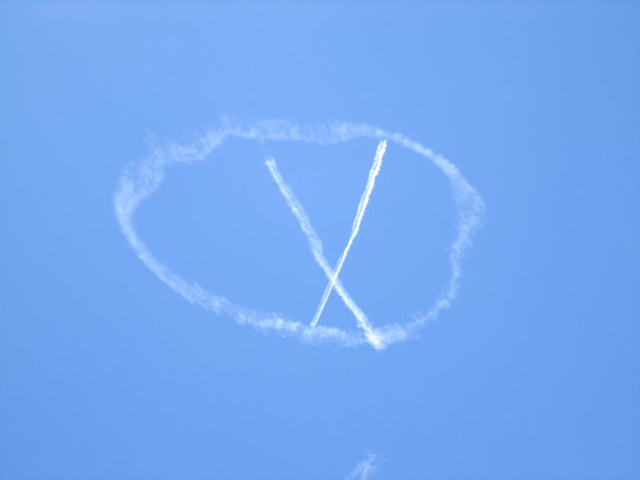
It is part of an advertising campaign for the Xmen film
Can you address this issue, specifically why it is misrepresented as evidence of Chemtrails?
Magneto was right! Do you live in a major American city and occasionally look up? You might have seen these X-Men symbols in the sky. It’s all a part of the marketing campaign for the “X-Men: First Class” movie, but I like to think that Cannonball might be involved somehow…
NW Pinball is going to have at least 402 games at their show. And yet I know I’m going to be stuck in line behind someone anyway…
It looks like Pacific Media Expo is lining up the English-language cast for “Tenchi Muyo” to be at their show. No specifics yet, although they say
BTW, I thought it appropriate to ask the questions which you asked of Mike Glynn.
SkyderALERT (Skyder Inc.) is a 501(c)4 Not-for-profit organization ? Really ? Non profit ? wonder how the IRS treated them ? Scam artist is what they are .
Assuming your name is real, you don't seem to be awfully serious about doing proper research. You make it look like this is a game for you.
Research costs money.
On the other hand, don't you think any 'chemtrail whistleblower' would have found a way to make money without your help? There are news organizations which would happily jump on a scoop like this - provided the whistleblower were genuine.
George, the challenge was not a bet, but an entreaty to use the available money to end any doubt about the problem. 25000 dollars will buy sufficient hours in either a properly fitted out biz jet or this:
.. to fully address any questions about what is contained in those white lines.
My preferred option is the German aircraft. You have sufficient European contacts in your movement to arrange proper scrutiny of the research and I am happy to fly to Germany, or the US if required to take part.
I have contacts in the Australian biz jet scene that can help here but I suspect that a Northern hemisphere venue may be preferred by yourself. Either way, if you are truly serious about this, it can be done.
Why would you rather give money to someone who may be lying to you, than spending money to put to rest the whole chemtrail issue for once and for all? Wouldn't it be great to finally PROVE they are spraying whatever it is you think theyre spraying? Or find out they aren't spraying anything, and be the one who blows the whole thing out of the water? So many people would rest easier, and find some real solutions to their ailments.
There are some pictures including the X in a O
Content from external source
The film entitled "Look UP!" deals with GeoEngineering, Solar Radiation Management (SRM), persistent contrails and is based on scientific research and data. When you see jets leaving trails in the sky, they may not simply be normal jet condensation trails… and if you look at the photos, you will most likely agree that something just doesn't look right.
@Skyder ALERT , I'm sorry, but that kickstarter page (archived here: http://archive.is/ut8HX) just screams HOAX. If you want to be taken seriously you really need to removed the more obvious nonsense, like the X-Men logo, the "Jet Aerosol Spray Device" (icing test nozzle), the claim that aluminum oxide is "highly reactive" (it's practically inert).
Why would you rather give money to someone who may be lying to you, than spending money to put to rest the whole chemtrail issue for once and for all? Wouldn't it be great to finally PROVE they are spraying whatever it is you think theyre spraying? Or find out they aren't spraying anything, and be the one who blows the whole thing out of the water? So many people would rest easier, and find some real solutions to their ailments.
I think you, and me and TWCobra and everyone else reading this knows the answer. As Mick has noted, it screams hoax. There's money to be made off the gullible. His kickstarter effort didn't raise the ambitious total, but the money it has raised, what happens to that? The sales of his DVD?
Possibly I'm about to break one of Mick's politeness guidelines, but George appears to be a con artist. If I'm out of line, Mick will remove this.
No, it's not out of line. It APPEARS to be a con. Unless George actually addresses the various issues, demonstrate that he either actually believes all the stuff that he posted, or admits to making honest mistakes, then that's really all anyone can take it as.
I suspect Skyder ALERT had forgotten that the "whistleblower" page was still up on his web site.
I posted this Tweet:
RossMarsden: .@SkyderALERT Is anyone monitoring the Whistleblower form on the web site? ow.ly/pYaJ7 I know of 2 offers this month. What news?
Original Message
And it was only after this prompt that I received an email with subject "thanks for the heads up ross...". The body of the email was the same as the unquoted part of comment #5 above.
even though Landrau asked me not to post any more before reading some terms on your site-- (which i wont)... here's my last post:
Hey ross it didn't flag cause it wasn't a whistleblower post,-- i thought you would be smart enough to know the difference between whistle blower and hot-air blower..i have responded to his non-whistleblower post.. now let me know when you answer my questions mike glynn...
and mick.. no its not a con...put up or shut up.. thats what i say. mike glynn posts on MY site and offers jets.... i'm calling him out.... answer the questions- bring the jets- put your money where your mouth is. i do.
Mike just offered to organize it for you, assuming you had the money to pay for it.
If it's not a con, then own up to the mistakes you made: the X-Men logo, the "Jet Aerosol Spray Device" (icing test nozzle), the claim that aluminum oxide is "highly reactive" (it's practically inert).
even though Landrau asked me not to post any more before reading some terms on your site-- (which i wont)... here's my last post:
Hey ross it didn't flag cause it wasn't a whistleblower post,-- i thought you would be smart enough to know the difference between whistle blower and hot-air blower..i have responded to his non-whistleblower post.. now let me know when you answer my questions mike glynn...
and mick.. no its not a con...put up or shut up.. thats what i say. mike glynn posts on MY site and offers jets.... i'm calling him out.... answer the questions- bring the jets- put your money where your mouth is. i do.
Why do have the need to be so rude. No one here is being rude to you. If you have a case, bring it. Your attitude suggests to me you know what you'll find if you take Mike up on his offer -- absolutely nothing unusual.
It's a wonder that whistle-blowers aren't crawling out of the woodwork. If this spraying is actually happening then there must be literally thousands of pilots involved. Then there is all that chemical to deal with. How many people to get it onto the trucks, how many to drive it from chemical manufacturing plant to all the airports, how many ground staff there to get onto the planes? This kind of conspiracy must involve staggering numbers of personnel, and so far none of them have spoken out - even though they're being sprayed too.
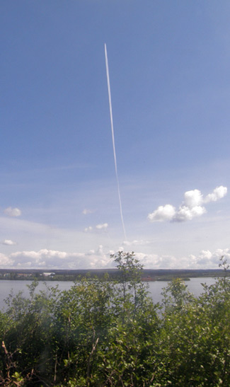
As an aside, I spotted the first persistent contrails in the skies over Helsinki last week. We very seldom see even fleeting contrails up here.
It's a wonder that whistle-blowers aren't crawling out of the woodwork. If this spraying is actually happening then there must be literally thousands of pilots involved. Then there is all that chemical to deal with. How many people to get it onto the trucks, how many to drive it from chemical manufacturing plant to all the airports, how many ground staff there to get onto the planes? This kind of conspiracy must involve staggering numbers of personnel, and so far none of them have spoken out - even though they're being sprayed too.
As an aside, I spotted the first persistent contrails in the skies over Helsinki last week. We very seldom see even fleeting contrails up here.
Am I the only one thinking that I would want a great deal more than 25k. That's what £15k? A few grand more than a minimum wage job for a year. Given the potential harm to ones life or career I would want something that would give financial security, something that a sweet media deal could offer. Strange no one has approached the press already.
Why would you rather give money to someone who may be lying to you, than spending money to put to rest the whole chemtrail issue for once and for all? Wouldn't it be great to finally PROVE they are spraying whatever it is you think theyre spraying? Or find out they aren't spraying anything, and be the one who blows the whole thing out of the water? So many people would rest easier, and find some real solutions to their ailments.
The whole Skyder concept was done a decade ago. All they added was an automated way to spam congress with more pictures of contrails, as if millions haven't already been taken and many thousands sent in. In 2000, the EPA, NOAA, NASA and FAA addressed the issue followed by the USAF.
many in congress have already spent thousands addressing this hoax. It is very likely that millions of dollars have been wasted on over a decade of futile efforts to maintain a so-called 'critical mass'. Nearly every bit of that was wasted, gone evaporated down the drain so far as solving anything.
George Barnes, if you run away from real critics who offer real solutions, your motives are as Max Bliss would say, "getting clearer...."
Jay, I'm not so sure Skyder, in it's detail, has been done before. What George has done is crowd-source the times and locations of the occurrences of persistent contrails. Yes, it is not exhaustive and all inclusive, and you can't tell where they are not occurring.
The Map page gives data like this:
Oct 21 2013 12:10 PM-GLEN MILLS-PA
Oct 21 2013 11:42 AM-CUSHING-Oklahoma
Oct 21 2013 11:28 AM-ANDERSON-IN
Oct 21 2013 11:18 AM-DAYTON-OH
So you have a time and a location; effectively an "address".
With a bit of programming you can isolate and re-express the address, pass it to a Google Map web service and get the latitude and longitude.
Take "Oct 21 2013 12:10 PM-GLEN MILLS-PA" for example...
The date part can be converted to a standard date format such as "12:10p.m. 21 Oct 2013" - use this to sync with other data.
A latitude and longitude in decimal format! Thank you Google!
Now you can plot the location of the photographed persistent contrail on a map with a satellite image, say Water Vapor, or some other meteorological data.
Of course, not all photos are of persistent contrails; some are of ephemeral contrails (George himself "submitted" one of these), some are of other suspicious cloud forms (AC or CC undulatus), and I have seen a selfie by some guy in France. (Outside the US, there is no address information on the "submissions" in the map list.)
Unfortunately, while the map page allows you to click on an item in the list and see a marker on the map with a thumbnail of the photo, you cannot click through to a larger version of it. I suspect that was the original plan. I much bring this to the attention of the web team there.
Anyway, you can see the potential of this growing resource:
Mash it up with weather data
Verify or debunk that the government shutdown resulted in a reduced "chemtrail operation"
Verify that some location did or didn't have persistent contrails during some period
Where are the "activists" most active or most concentrated?
Where are the "activist" growth areas?
George now has an email address collection campaign to increase the size of the crowd collecting the data. In a recent email update, (I hope that link works for everyone)
The top 10 people that submit the most email addresses will each get a free DVD!
(image of a DVD)
The top 3 people providing the most email addresses will get a new Global March Against Chemtrails official T-shirt for the upcoming Jan 25, 2014 march!
(image of a T-shirt)
And the person that sends us the most email addresses will get the
"Answer to Cancer" book ! -- something every one should have!
(image of a book)
This great work George! I, for one, can't thank you enough.
Oh, OK. That is the last 5000, back to 19 Sep 2013.
Excellent! Links to the full sized photos and all! I see some locations in Europe: "longitude": -7.174367, "latitude": 52.1657523
I suppose it's possible to go back to when the project started in May.
George, do you really expect to convince anyone that this non-persistent contrail is something unusual?
So now, by your example earlier this month, even non-persistent contrails are a "civil rights violation"?
How far down can you drive this hoax before you lose the plot?
I cannot fathom what is going on in your mind, man?
You guys metabunk guys write "Real Solutions", and "Challenge"... I appreciate your being so convinced on your position, that i offer you this challenge- Since Mike Glynn said 25k would be plenty to do the flights and testing, and he offered to coordinate same (according to mick) this is YOUR opportunity to have YOUR position proven beyond a doubt at no cost to you.
SkyderALERT and Metabunk each put up $25,000 into an attorney trust account… you coordinate the jets i pick the schedule(scramble) and location we will bring the news crew, film team, and environmental engineering firm- we fly on a heavy persistent contrail day- newscast the whole thing… pay unto 20k for flights, 5k for testing, and if the tests show up only some soot and di-hydrogen monoxide, you get the your 25k back, and your point is proven, If they show up something else..., we get our 25k back and our point is proven.
Don't misinterpret being direct for being "impolite"… PUT UP OR SHUT UP.
What do you say TWCcobra..lets "end the question once and all"
How bout you Jay Reynolds.. this is a the only "real solution"
Mike Glynn, i am answering your "Challenge"
Come on Mick West, lets see who "Made the mistake"
This is probably my last post until you guys put your money where your mouth is.
You guys metabunk guys write "Real Solutions", and "Challenge"... I appreciate your being so convinced on your position, that i offer you this challenge- Since Mike Glynn said 25k would be plenty to do the flights and testing, and he offered to coordinate same (according to mick) this is YOUR opportunity to have YOUR position proven beyond a doubt at no cost to you.
You guys metabunk guys write "Real Solutions", and "Challenge"... I appreciate your being so convinced on your position, that i offer you this challenge- Since Mike Glynn said 25k would be plenty to do the flights and testing, and he offered to coordinate same (according to mick) this is YOUR opportunity to have YOUR position proven beyond a doubt at no cost to you.
SkyderALERT and Metabunk each put up $25,000 into an attorney trust account… you coordinate the jets i pick the schedule(scramble) and location we will bring the news crew, film team, and environmental engineering firm- we fly on a heavy persistent contrail day- newscast the whole thing… pay unto 20k for flights, 5k for testing, and if the tests show up only some soot and di-hydrogen monoxide, you get the your 25k back, and your point is proven, If they show up something else..., we get our 25k back and our point is proven.
Don't misinterpret being direct for being "impolite"… PUT UP OR SHUT UP.
What do you say TWCcobra..lets "end the question once and all"
How bout you Jay Reynolds.. this is a the only "real solution"
Mike Glynn, i am answering your "Challenge"
Come on Mick West, lets see who "Made the mistake"
This is probably my last post until you guys put your money where your mouth is.
This is kind of illustrating to me that, assuming you are really Skyder Alert, this is all about moving goalposts, upping antes, and distraction than about learning anything. First of all you need to define "SOMETHING ELSE".
I do not think you are interested in ending anything once and for all. You appear to have $25,000 which can either be used to learn something, or to throw at some anonymous "whistleblower" person who would probably opt to go to a mainstream source that would pay him 10 times that if they were real. Or maybe you don't have $25,000 at all. I think YOU are the one who needs to put their money where their mouth it.
On a related note, last night on Russ Tanners audio John Massaria said he has a friend who has a friend who has a friend who spilled all the beans to him. Maybe you can track him down.
SkyderALERT and Metabunk each put up $25,000 into an attorney trust account…
How bout you Jay Reynolds.. this is a the only "real solution"
This is probably my last post until you guys put your money where your mouth is.
George, I don't invest money in hoaxes, only a fool does that.
You are no fool, and neither is Thomas Conigliaro, a member of your CORPORATION, and a multi-millionaire investment banker. He files lawsuits over stuff all the time. If he actually believed his civil rights were being violated, he would have put his extensive financial and legal resources behind a solution. Conigliaro travels the world in business jets, he probably has one at his disposal 24/7/365.
The activities of the Skyder CORPORATION bear no resemblance to a group dedicated to finding solutions. Your actions show, however, a dedication for self-perpetuation of a hoax. You know full well that there are many crowd-sourced opportunities to put this this hoax to rest once and for all, but specifically designed the Skyder App as an updated crowd sourcing "Boy Who Cried Wolf" application. Why on earth would you do that?
Look at all the photos on skyder. We got nailed in CO today. It turned into a whiteout. This stuff is bad news. My aluminum level is 6x abnormal. Tell me where else is it coming from? I cough on this crud. So does my wife. My friend gets migraines on heavy spray days. We have had the spider webby stuff float down before when wind came up unexpected. The fish spine clouds and bizarre looking fake crud is NOT NORMAL. They are spraying the crap out of us. Lord help us all. I think it is due to panic over the arctic ice melt.