Sandy, Evan, Oswald... Weather Warfare?

Status
Not open for further replies.
No offense but just reading the screen shot your posted suggests that isn't entirely accurate as he fully acknowledges the merging of the elements into one storm- hence the comment:

...allow this unusual merger to take place...an allusion to Mary Shelley's gothic creature of synthesized elements
Content from External Source
It was near Halloween so he looked for a "ghoulish name" but chose Frankenstorm due the combining of elements to create the broader storm.

I understand that......which is why I also mentioned Hurricane Grace a little later.......the "nothing more, nothing less" comment was to imply he suggested the nickname for those reasons we both mentioned and not that he had some knowledge that it was a manufactured storm as this thread starter wonders about in his blog......
 
I understand that......which is why I also mentioned Hurricane Grace a little later.......the "nothing more, nothing less" comment was to imply he suggested the nickname for those reasons we both mentioned and not that he had some knowledge that it was a manufactured storm as this thread starter wonders about in his blog......

Got it!

Indeed- the name of the storm is not "evidence" of weather manipulation ;)
 
I understand that......which is why I also mentioned Hurricane Grace a little later.......the "nothing more, nothing less" comment was to imply he suggested the nickname for those reasons we both mentioned and not that he had some knowledge that it was a manufactured storm as this thread starter wonders about in his blog......

Thanks for the confirmation!
 
... Try again Jaybird


Originally Posted by Jay Reynolds

...
That ability doesn't always translate into sound factual knowledge or reasoning, however.

So many artists I've found lack experience in analysis and don't usually apply logic to problems.
His point was valid as a general observation.
 
Last edited by a moderator:
No I dont take offence, thanks for your insight. However, I think there is enough evidence of the existence of weather and environmental warfare that we should begin to question storms, earthquakes etc.
===
snip long list of somewhat irrelevant links.

SH,
What you did was called a "Gish Gallop". It is considered poor form because often times it is a tactic.

The Gish Gallop, named after creationist Duane Gish, is the debating technique of drowning the opponent in such a torrent of half-truths, lies, and straw-man arguments that the opponent cannot possibly answer every falsehood in real time. The term was coined by Eugenie Scott of the National Center for Science Education. Sam Harris describes the technique as "starting 10 fires in 10 minutes."
The formal debating jargon term for this is spreading.[1] It arose as a way to throw as much rubbish into five minutes as possible. In response, some debate judges now limit number of arguments as well as time. However, in places where debating judges aren't there to call bullshit on the practice, like the internet, such techniques are remarkably common.

Rather than quote your website's entire set of documentation, which is already available, please do as I asked in my first response. Pare it down to the three most irrefutable facts which supply the evidence that weather and environmental warfare exists. Put them in order of significance from best to worst, if you like.

1. ?
2. ?
3. ?

This will make a fruitful discussion more possible, at least for left-brainers like me.

Think of it as it were a piece of art. Yes, you could simply look and say, I Like or I Hate, but what is it really that you actually find likeable about the piece, is it the texture, the pattern, the color, the symbolism, the contrast
============?

The second part of your statement says that "we should begin to question storms, earthquakes, etc."

I have some questions for you:

1.Now earthquakes? Why not volcanoes and forest fires as well?

2. But why and to what purpose do these questions get asked?

3. Does simply asking questions advance anything?

4. What would be the effect of asking them?

5. To whom would you ask them?

6. What sort of answers will you be able to rely on if you get one?

7. What will you do with the answers you get and can rely on?

Hope to hear from you soon.
Jay
 
Okay. we`ll move on to the next storm.

So you admit Sandy was not "geoengineered"?

Scombrid did a very good job of addressing your coincidental points. As someone who has lived on LI my entire life, I practically LOLed reading them.
 
SH,
What you did was called a "Gish Gallop". It is considered poor form because often times it is a tactic.


Rather than quote your website's entire set of documentation, which is already available, please do as I asked in my first response. Pare it down to the three most irrefutable facts which supply the evidence that weather and environmental warfare exists. Put them in order of significance from best to worst, if you like.

1. ?
2. ?
3. ?

This will make a fruitful discussion more possible, at least for left-brainers like me.

Think of it as it were a piece of art. Yes, you could simply look and say, I Like or I Hate, but what is it really that you actually find likeable about the piece, is it the texture, the pattern, the color, the symbolism, the contrast
============?

The second part of your statement says that "we should begin to question storms, earthquakes, etc."

I have some questions for you:

1.Now earthquakes? Why not volcanoes and forest fires as well?

2. But why and to what purpose do these questions get asked?

3. Does simply asking questions advance anything?

4. What would be the effect of asking them?

5. To whom would you ask them?

6. What sort of answers will you be able to rely on if you get one?

7. What will you do with the answers you get and can rely on?

Hope to hear from you soon.
Jay


I have some questions for you:

1. Now earthquakes? Why not volcanoes and forest fires as well?

If you like. I think at present weather modification and warfare should be looked at more-so because of its effect on climate.

2. But why and to what purpose do these questions get asked?

Weather modification effects climate, i am concerned and I think others should be too.

3. Does simply asking questions advance anything?

Yes, promotes discussion on the topic. Very important topic (weather and environmental modification)

4. What would be the effect of asking them?

Promotes discussion. Limits the use of weather and environmental modification.

5. To whom would you ask them?

”Intervention in atmospheric and climatic matters . . . will unfold on a scale difficult to imagine at present. . . . this will merge each nation’s affairs with those of every other, more thoroughly than the threat of a nuclear or any other war would have done.” – John von Neumann

6. What sort of answers will you be able to rely on if you get one?

Proof of the existence of weather and environmental modification technology.

7. What will you do with the answers you get and can rely on?

Expose the effect on climate.

I have presented plenty of evidence on this thread of weather and environmental modification.

In the United States there are a number of civilian run weather modification programs and associations, for example “Weather Modification, Inc.” and the “Weather Modification Association”. In China the “Beijing Weather Modification Office” runs as a unit of the Beijing Meteorological Bureau. The Beijing Weather Modification Office form a part of China’s nationwide weather control effort, believed to be the world’s largest and it employs 37,000 people nationwide.

Thats at a civilian level, imagine the capabilities of military level.

The United States military used weather modification in the Vietnam War to limit the movement of the enemy. Please refer to the Wikipedia link below.

Operation Popeye : Wikipedia

This cloud seeding operation ran for five years, resulting in targeted areas seeing an extension of the monsoon period an average of 30 to 45 days. The continuous rainfall slowed down the truck traffic and it was considered relatively successful. This military operation was conducted forty years ago and the calculator on my desk is faster than the computers that existed back then. What can they do with weather modification now? How far have governments advanced in this field? The document by NASA that I have added above talks about the fact that even small changes in the abundance or location of clouds can effect climate. Operation Popeye extended monsoon periods for 45 days. That’s more than just an increase in the abundance of clouds, that’s a monsoon.

http://en.wikipedia.org/wiki/Monsoon


That was forty years ago, imagine the military capabilities of weather modification now...
 
Much of what the History Channel now shows is entertainment, not history, not science, not even well researched.
 
Evidence has been gathering a lot since the original post. I am continuing to improve the website.

http://weatherwarfare.worldatwar.info

Hurricane Sandy was the deadliest and most destructive hurricane of the 2012 Atlantic hurricane season, as well as the second-costliest hurricane in United States history. Hurricane Sandy was also the largest Atlantic hurricane ever recorded (as measured by diameter with winds spanning 1,100 miles (1,800 km)). The severe and widespread damage the storm caused in the United States, as well as its unusual merge with a frontal system, resulted in the nicknaming of the hurricane by the media and several organizations of the U.S. government “Super-storm Sandy”. I believe that there are too many unusual occurrences and coincidences for me to accept that this storm was a natural creation.

http://en.wikipedia.org/wiki/Hurricane_Sandy

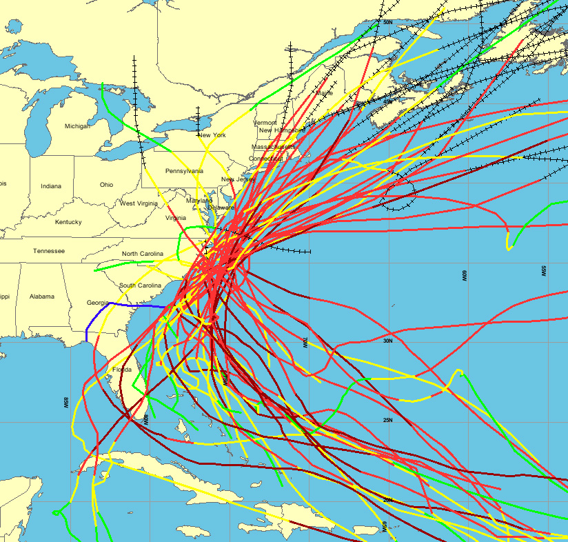
Sandy developed from a tropical wave in the western Caribbean Sea on October 22, quickly strengthened, and was upgraded to Tropical Storm Sandy six hours later. As the storm reached the North American coastline, the storm begins to curve with the coastline and stay the same distance away from the coastline of North Carolina, South Carolina and Florida, rather than following a direct path (Refer to images provided). The storm then changes direction and heads west towards New Jersey and Philadelphia. While curving west towards New Jersey, the storm accelerated to a forward motion of nearly 30mph (The hybridization of Sandy – Atmos News (by Bob Henson)). When the storm reached Philadelphia it made a ninety degree turn (rather than going inland), heading through the western parts of New York and then up the east coast through Ottawa, Montreal, Quebec and New Brunswick. The storm lasted for a period of five days, hitting the most populated area of the east coast. Coincidentally, it also seems to circle the business capital of the United States, New York City. Circling New York is the same as hitting it head on and if the United States was the subject of an attack, New York would be one of the primary targets (note September 11, 2001).

On October 25th The National Weather Service accurately predicted Hurricane Sandy would make landfall in southeastern New Jersey four days prior to actually making landfall. This is the same day that Hurricane Sandy was dubbed “Frankenstorm” by NOAA (National Oceanic and Atmospheric Administration). If you remember the story of “Frankenstein”, Frankenstein was put together with different body parts and struck by lightning to give him life. Frankenstein was manufactured. If Hurricane Sandy was labeled Frankenstorm, maybe it was manufactured too? Is this the correlation between Frankenstein and Frankenstorm? Conspiracy or coincidence? Interestingly enough, Hurricane Sandy sped up just before New Jersey (as sourced earlier in the post), just before the major catastrophe of the storm. It is very coincidental that Hurricane Sandy was dubbed Frankenstorm the same day the National Weather Service predicted the storm would make landfall in New Jersey. Apparently, the European weather models were very accurate in predicting what Hurricane Sandy would do ahead of time. How accurate were the models exactly? Did they predict that Sandy would speed up just before New Jersey?

Hurricane Sandy’s devastating storm track is a rare one among hurricanes; a new statistical analysis estimates that the track of the storm — which took an unusual left-hand turn in the Atlantic before slamming into the East Coast — has an average probability of happening only once every 700 years. “The particular shape of Sandy’s trajectory is very peculiar, and that’s very rare, on the order of once every 700 years,” said Timothy Hall, a senior scientist at the NASA Goddard Institute for Space Studies who co-authored the study. That means that in any particular year, the chance of such a storm track happening is 0.0014 percent (Refer to NASA Simulation – Media). Source – Hurricane Sandy Was 1- in-700-Year Event: http://news.yahoo.com/hurricane-sandy-1-700-event-182934012.html
An article by Dr. Jeff Masters states (Weather Underground): http://www.wunderground.com/blog/JeffMasters/comment.html?entrynum=2283

“We’re used to seeing hurricane-battered beaches and flooded cities in Florida, North Carolina, and the Gulf Coast. But to see these images from the Jersey Shore and New York City in the wake of Hurricane Sandy is a shocking experience. New Jersey only rarely gets hit by hurricanes because it lies in a portion of the coast that doesn’t stick out much, and is too far north. How did this happen? How was a hurricane able to move from southeast to northwest at landfall, so far north, and so late in hurricane season? We expect hurricanes to move from east to west in the tropics, where the prevailing trade winds blow that direction. But the prevailing wind direction reverses at mid-latitudes, flowing predominately west-to-east, due to the spin of the Earth. Hurricanes that penetrate to about Florida’s latitude usually get caught up in these westerly winds, and are whisked northeastwards, out to sea.”

Super-storm Sandy made landfall just when a full moon was brightening the sky. The moons gravity pulls on earths water, fractionally lifting the surface towards itself. Oceans bulge towards the moon to generate two oceanic tides per day. During a full moon, the moons gravity can align with that of the sun to produce particularly high tides. The full moon during the storm put an extra 6 feet onto the sea level. Also, sea level pressure hits peak just as Sandy makes landfall, 952hPa and surface wind speed hits peak just as Sandy makes landfall, 92mph. Very coincidental that so many aspects of the storm coincide with landfall. Even the track of Sandy coincides with landfall.

“Sandy’s track was the most perpendicular to the Atlantic Coast of any storm on record”. – http://news.nationalgeographic.com/...imate-change-superstorm-sandy-global-warming- storms-science-weather/

In elementary geometry, the word perpendicular describes the relationship between two geometric objects that meet at a right angle.

An article by Amy Ellis Nutt and Stephen Stirling states: http://www.nj.com/news/index.ssf/2012/11/experts_argue_global_warmings.html

“It wasn’t supposed to happen. That’s what the weather experts kept saying immediately before, during and after Sandy smacked New Jersey in the face. Not this far north, they said, not in autumn, and certainly not this bad.”

I believe that there are too many unusual occurrences and coincidences for me to accept that this storm was a natural creation.

Stunning simulation of Hurricane Sandy:

Watch as Hurricane Sandy gathers wind speed along the East Coast and take note the transition of the storm until it makes landfall. Also note the change in the storm as it makes landfall. This video by NASA makes me feel like Sandy is a weapon that builds up wind speed and explodes on the New York State area. The storm seems to have a splash effect as it makes landfall. Via NASA: This simulation runs from Oct. 26 to Oct. 31, 2012, highlighting Hurricane Sandy’s near- surface (850 hPa) winds. More information: http://svs.gsfc.nasa.gov/vis/a030000/a030000/a030019/


Diagram below shows Sea level pressure, wind speeds, and accumulated rainfall from a GEOS-5 7-km simulation. Note the diagram on Sea level pressure. Sea level pressure hits peak just as Sandy makes landfall, 952hPa. Note the diagram on surface wind speeds. Surface wind speed hits peak just as Sandy makes landfall, 92mph. More information: http://svs.gsfc.nasa.gov/vis/a030000/a030000/a030019/

http://weatherwarfare.worldatwar.info/wp-content/uploads/2013/06/superstormsandy1-1024x575.jpg

List and Explanation of Hurricane Sandy Unusual Occurrences and Coincidences

#1 – Hurricane Sandy was the largest Atlantic hurricane ever recorded. (as measured by diameter with winds spanning 1,100 miles (1,800 km)).

#2 – If you look at the topography, when the storm reaches North America it continues to stay the around the same distance away from the coastline. (It is very rare that coastline effects the path of a storm. It seems that the coastline had a lot to do with the track of this storm. Note the distance of coastline that effected Super-storm Sandy).

#3 – The storm curves with with the coastline of North Carolina, South Carolina and Florida. (Once again, it is very rare that coastline effects the path of a storm, let alone curves with the coastline of a continent).

#4 – The storm speeds up just as it heads towards New Jersey. (From the start, the storm moved at a steady rate and then just before the major catastrophe of the storm, it speeds up, just before it circles New York City).

#5 – The storm moves in a circle around New York City (New York is the business capital of the United States. Circling New York is the same as hitting it head on and if the United States was the subject of an attack, New York would be one of the primary targets (note September 11, 2001)).

#6 – Hurricane Sandy is the largest Atlantic hurricane ever recorded and it hits late in the hurricane season. (You would think that the largest hurricane ever recorded would hit in peak period).

#7 – This hurricane is very far north in comparison to other Atlantic hurricanes. (Most Atlantic hurricanes hit Florida and very rarely go any further. If hurricanes do go any further, they usually head from west to east because the prevailing winds blow that direction. Hurricane Sandy headed from East to West towards the New York State Area).

#8 – Sandy had the biggest storm surge ever seen. (The storm surge of Sandy has created some of the worst flooding from a hurricane in a very long time).

#9 – Hurricane Sandy is very fast for a hurricane. (So, Hurricane Sandy is the largest in diameter, its very fast for a hurricane, its not at the right time, its very far north for a hurricane and had the worst flooding from a hurricane in a very long time. Too many unusual occurrences and coincidences for me to accept that this storm is a natural creation).

#10 – Forecasters labeled Hurricane Sandy “Frankenstorm“… If you remember “Frankenstein” was created, he was not born, he was manufactured.

#11 – Hurricane Sandy sped up just before New Jersey, just before the major catastrophe of the storm. It is very coincidental that Hurricane Sandy was dubbed Frankenstorm the same day the National Weather Service predicted the storm would make landfall in New Jersey. Did the weather models and predictions predict the storm speeding up before New Jersey?

#12 – Sandy had the most kinetic energy of all tropical cyclones on record at 222 trillion Joules (the equivalent of 3.5 Little Boy Hiroshima atomic bombs).

#13 – Sea level pressure hits peak just as Sandy makes landfall, 952hPa.

#14 – Surface wind speed hits peak just as Sandy makes landfall, 92mph.

#15 – Sandy’s track was the most perpendicular to the Atlantic Coast of any storm on record (In elementary geometry, the word perpendicular describes the relationship between two geometric objects that meet at a right angle).

#16 – Hurricane Sandy Was 1-in-700-Year Event – Hurricane Sandy’s devastating storm track is a rare one among hurricanes; a new statistical analysis estimates that the track of the storm — which took an unusual left-hand turn in the Atlantic before slamming into the East Coast — has an average probability of happening only once every 700 years. “The particular shape of Sandy’s trajectory is very peculiar, and that’s very rare, on the order of once every 700 years,” said Timothy Hall, a senior scientist at the NASA Goddard Institute for Space Studies who co-authored the study. That means that in any particular year, the chance of such a storm track happening is 0.0014 percent.

#17 – The moons gravity pulls on earths water, fractionally lifting the surface towards itself. Oceans bulge towards the moon to generate two oceanic tides per day. During a full moon, the moons gravity can align with that of the sun to produce particularly high tides. Super-storm Sandy made landfall just when a full moon was brightening the sky. The full moon during the storm gave an extra 6 feet onto the sea level, 20% higher than normal. (Source below Hurricane Sandy – What Really Happened (Documentary) – 37:40)

 
The way i remember Frankenstein was put together by Dr. Frankenstein? and struck by lightning to give him life? Maybe the story changes?
 
List and Explanation of Hurricane Sandy Unusual Occurrences and Coincidences
Content from External Source
I'll just pick a few.


#2 – If you look at the topography, when the storm reaches North America it continues to stay the around the same distance away from the coastline. (It is very rare that coastline effects the path of a storm. It seems that the coastline had a lot to do with the track of this storm. Note the distance of coastline that effected Super-storm Sandy).
Content from External Source
Well, that's not true. Many track the same way


#3 – The storm curves with with the coastline of North Carolina, South Carolina and Florida. (Once again, it is very rare that coastline effects the path of a storm, let alone curves with the coastline of a continent).
Content from External Source
See comment above.

#5 – The storm moves in a circle around New York City (New York is the business capital of the United States. Circling New York is the same as hitting it head on and if the United States was the subject of an attack, New York would be one of the primary targets (note September 11, 2001)).
Content from External Source
How is "circling" the same thing as "hitting straight on."?

#6 – Hurricane Sandy is the largest Atlantic hurricane ever recorded and it hits late in the hurricane season. (You would think that the largest hurricane ever recorded would hit in peak period).
Content from External Source
I guess "what you would think" doesn't really matter, does it?


#7 – This hurricane is very far north in comparison to other Atlantic hurricanes. (Most Atlantic hurricanes hit Florida and very rarely go any further. If hurricanes do go any further, they usually head from west to east because the prevailing winds blow that direction. Hurricane Sandy headed from East to West towards the New York State Area).
Content from External Source
Yes we've only had two hurricanes EVER on Long Island. /sarcasm off.

#8 – Sandy had the biggest storm surge ever seen. (The storm surge of Sandy has created some of the worst flooding from a hurricane in a very long time).
Content from External Source
"in a very long time." So?

#9 – Hurricane Sandy is very fast for a hurricane. (So, Hurricane Sandy is the largest in diameter, its very fast for a hurricane, its not at the right time, its very far north for a hurricane and had the worst flooding from a hurricane in a very long time. Too many unusual occurrences and coincidences for me to accept that this storm is a natural creation).
Content from External Source
Nothing you stated so far was unusual. Continuing....


#10 – Forecasters labeled Hurricane Sandy “Frankenstorm“… If you remember “Frankenstein” was created, he was not born, he was manufactured.
Content from External Source
Of course, THAT definitely means it was manufactured. And whoever manufactured it told all the newscasters to call it "Frankenstorm" just to give you a clue.


#11 – Hurricane Sandy sped up just before New Jersey, just before the major catastrophe of the storm. It is very coincidental that Hurricane Sandy was dubbed Frankenstorm the same day the National Weather Service predicted the storm would make landfall in New Jersey. Did the weather models and predictions predict the storm speeding up before New Jersey?
Content from External Source
I don't get this one.

#12 – Sandy had the most kinetic energy of all tropical cyclones on record at 222 trillion Joules (the equivalent of 3.5 Little Boy Hiroshima atomic bombs).

#13 – Sea level pressure hits peak just as Sandy makes landfall, 952hPa.

#14 – Surface wind speed hits peak just as Sandy makes landfall, 92mph.
Content from External Source
Was the Hurricane of 1938 also manufactured? Winds of 160 mph. No warning at all? Damage at 4.3 billion when adjusted to today's dollars.

#15 – Sandy’s track was the most perpendicular to the Atlantic Coast of any storm on record (In elementary geometry, the word perpendicular describes the relationship between two geometric objects that meet at a right angle).
Content from External Source
Repeat of #2.

#16 – Hurricane Sandy Was 1-in-700-Year Event – Hurricane Sandy’s devastating storm track is a rare one among hurricanes; a new statistical analysis estimates that the track of the storm — which took an unusual left-hand turn in the Atlantic before slamming into the East Coast — has an average probability of happening only once every 700 years. “The particular shape of Sandy’s trajectory is very peculiar, and that’s very rare, on the order of once every 700 years,” said Timothy Hall, a senior scientist at the NASA Goddard Institute for Space Studies who co-authored the study. That means that in any particular year, the chance of such a storm track happening is 0.0014 percent.
Content from External Source
Deja vu all over again.

#17 – The moons gravity pulls on earths water, fractionally lifting the surface towards itself. Oceans bulge towards the moon to generate two oceanic tides per day. During a full moon, the moons gravity can align with that of the sun to produce particularly high tides. Super-storm Sandy made landfall just when a full moon was brightening the sky. The full moon during the storm gave an extra 6 feet onto the sea level, 20% higher than normal. (Source below Hurricane Sandy – What Really Happened (Documentary) – 37:40)
Content from External Source
LOL. What TIMING.
 
The way i remember Frankenstein was put together by Dr. Frankenstein? and struck by lightning to give him life? Maybe the story changes?
The creature is never named and the only Frankensteins are Victor and his family, who were born, hence I was been pedantic.
 
Being as the Monster was re-animated flesh, I reckon that flesh/body parts had to have been born at one time. Do not recall anything properly being created or grown in the good doctors body part growing laboratory. I recall the monster was created out of existing body parts scavenged from the dead (were they not convicts who were executed or am I dreaming that part)...oh, that means they were born too....
 
#3 – The storm curves with with the coastline of North Carolina, South Carolina and Florida. (Once again, it is very rare that coastline effects the path of a storm, let alone curves with the coastline of a continent).

Actually, that is not accurate. It IS normal for storms to curve with the east-coastline- that is a typical pattern. The unusual (but not unheard of) part was the left turn and the perpendicular landfall.

This is every Hurricane within 65 miles of Cape Hatteras, NC since 1900:


http://www.noaanews.noaa.gov/stories2010/20100930_hurricanetrack.html
 
Last edited by a moderator:
Another Gish Gallop with points already shown to be wrong. You could have eliminated several of your points with 10 minutes of searching the web. Heck, even Wikipedia destroys some of your points.

Remember that before the time of weather satellites that the sizes of storms were not easy to measure.


https://en.wikipedia.org/wiki/List_of_New_England_hurricanes

Here are a few from the list there

August 25, 1635- The Great Colonial Hurricane of 1635 struck Narragansett Bay as a possible category 4 or 5 hurricane. It killed 46+ people.

October 18–19, 1782- A second hurricane moved up the coast and was considered more severe than the previous storm in portions of New England, especially Boston. This was a rare snow hurricane for New England and the storm was likely transforming into an extratropical cyclone as it approached the New England states.
September 24–25, 1785- A hurricane which made landfall near Ocracoke, North Carolina impacted southern New England. Based on known observations, this hurricane remained offshore of New England but passed close enough to inflict heavy rain and strong winds to New York City and Boston.

September 23–24, 1815 – The Great September Gale of 1815 struck New England as a major hurricane and delivered an 11-foot storm surge that funneled up Narragansett Bay where it destroyed some 500 houses and 35 ships and flooded Providence, Rhode Island. It also caused 38+ deaths all over New England.


August 27, 1827- The St. Kitts Hurricane impacted the eastern seaboard from Wilmington, North Carolina to Portsmouth, New Hampshire. It is possible that this cyclone made landfall along the United States but there are also conflicting reports that say it remained offshore of Cape Hatteras, Delaware, and Nantucket. August 1827 was a very active month with at least four hurricanes impacting the North Atlantic.

August 1830 – Two hurricanes passed close to southeastern Massachusetts within a week of each other. First came the Atlantic Coast Hurricane on August 19 followed by a second hurricane around the 25th. Damage from these two blows was duly noted on Nantucket. It appears that the later system approached the region from the southeast before turning out to sea southeast of Cape Cod.

October 11, 1830 – A third hurricane impacted New England in 1830 but like the two in August, this cyclone did not make landfall in New England. Barnestable, Massachusetts reported the storm.

1924 August - Category 2/3 - large center moved over and just east of Cape Cod. Severe hurricane in New Bedford and Martha's Vineyard Massachusetts. New Bedford Newspaper (Mercury) published photo journal of severity. Often overlooked though much material present to include as destructive storm. On Cape Cod, Martha's Vineyard and Nantucket considered worse than 1938. Widespread wind losses to structures. Very heavy tree damage in New Bedford north to Plymouth Massachusetts. Storm later destructive in Nova Scotia.


1944 September- 15 - Great Atlantic Hurricane - Category 3 in southern New England. Eye over Conn. /Rhode Island border. Severe wind damage in southeastern Massachusetts and across the Cape and Islands. On Cape Cod and Martha's Vineyard considered worse than 1938. Severe wind damage in New Bedford, Massachusetts. Much structural damage and much of the forest that had somehow escaped being decimated in 1938 fell victim to this storm.

1950 September - Hurricane Dog - Major offshore hurricane — largest in size of all Atlantic storms — moved very close to Nantucket. Hurricane conditions over southeast Massachusetts. New Bedford Airport at 11pm observation reported sustained wind from the north at 75 mph (121 km/h) with gust to 100 mph (160 km/h). Very large, intense storm.


1954 August - Hurricane Carol - Category 3- wind gusts of category four strength in southeast Rhode Island and south coastal Massachusetts in the Buzzards Bay area west of Cape Cod. 60 killed. Extreme damage in coastal south Rhode Island and south coastal Massachusetts. Buzzards Bay damage rivaled 1938 storm.

1954 September - Hurricane Edna - second Category 3 hurricane in two weeks in New England made two landfalls, eye over Martha's Vineyard and Cape Cod then again on coast of Maine where very severe losses occurred. Winds recorded at the hourly reading at 90 mph New Bedford Airport, New Bedford, Ma; 100 mph at Taunton, Ma. 112 mph at Milton Ma, and 125 mph at Chilmark, Martha's Vineyard Island.

1999 September 17–18 Hurricane Floyd – After paralleling much of the U.S. East Coast, Tropical Storm Floyd moves into Connecticut, and tracks northward through Maine. Floyd causes large power outages and flood damage across the region, with over five inches (130 mm) of rain falling over most of the area. Danbury, Connecticut received up to 15 inches (380 mm) of rain from the storm, resulting in extensive flooding in the city and surrounding areas. Mudslides were reported in the Berkshire Mountains of western Massachusetts. Several major highways and a countless number of local roads in Connecticut and Massachusetts were closed for several days due to flooding, and downed trees and power lines. Hurricane force wind gusts were observed in southern Rhode Island: North Kingston unofficially 90 mph.Wind gusts to 76 mph at New Bedford Hurricane Dike in New Bedford, Massachusetts and 73 mph in Hyannis, Massachusetts.

Content from External Source

https://en.wikipedia.org/wiki/1938_New_England_hurricane

http://www.yankeemagazine.com/best-of-new-england/worst-hurricanes-in-new-england-history
 
These exact points have been posted elsewhere and already debunked. I strongly suggest you take the time to look around the forum and see if your claims have already been addressed.

The NWS explained "Frankenstorm" in its discussion.

PRELIMINARY EXTENDED FORECAST DISCUSSION
NWS HYDROMETEOROLOGICAL PREDICTION CENTER COLLEGE PARK MD
942 AM EDT THU OCT 25 2012

VALID 12Z MON OCT 29 2012 – 12Z THU NOV 01 2012

…HIGH IMPACT MERGING OF ENERGETIC SYSTEMS ANTICIPATED OFF THE MID ATLANTIC COAST…

PRELIMINARY UPDATE…

DESPITE A MODEST CLUSTER OF OUTLYING DETERMINISTIC SOLUTIONS AND ENSEMBLE MEMBERS FROM THE VARIOUS MODELING CENTERS, THE LION’S SHARE OF GUIDANCE INDICATES THAT THE CIRCULATION ASSOCIATED WITH HURRICANE SANDY WILL PASS CLOSE ENOUGH TO THE AMPLIFYING POLAR TROUGH OVER THE EASTERN UNITED STATES TO BECOME INCORPORATED INTO A HYBRID VORTEX OVER THE MID ATLANTIC AND NORTHEAST NEXT TUESDAY. THE HIGH DEGREE OF BLOCKING FROM EASTERN NORTH AMERICA ACROSS THE ENTIRE ATLANTIC BASIN IS EXPECTED TO ALLOW THIS UNUSUAL MERGER TO TAKE PLACE, AND ONCE THE COMBINED GYRE MATERIALIZES, IT SHOULD SETTLE BACK TOWARD THE INTERIOR NORTHEAST THROUGH HALLOWEEN, INVITING PERHAPS A GHOULISH NICKNAME FOR THE CYCLONE ALONG THE LINES OF “FRANKENSTORM”, AN ALLUSION TO MARY SHELLEY’S GOTHIC CREATURE OF SYNTHESIZED ELEMENTS.

AS IS OFTEN THE CASE, WHEN ONE PART OF THE NATION IS EXPERIENCING A VERY ENERGETIC ATMOSPHERE DISTURBANCE, THE REMAINDER IS RELATIVELY CALM. THIS EVENT SHOULD NOT PROVE THE EXCEPTION, WITH A FAIRLY BENIGN FEED OF PACIFIC AIR INTO MOST OF THE WESTERN AND CENTRAL STATES. THE FAR WEST, PARTICULAR NORTH OF CALIFORNIA, WILL HAVE ENOUGH SUSTAINED ONSHORE FLOW TO KEEP THE PERIOD WET AND UNSETTLED.

CISCO
 
Okay, subhumn, you're 14 posts in...
at what point are you going to introduce some (any!) meteorological evidence that Sandy (or Evan or Oswald) was man-made?


Tip for teens: If you never offer any real evidence, many folks are going to take this as merely a deceitful attempt to build traffic on that wacky little "Weather Warfare" site
 
Status
Not open for further replies.
Back
Top