S4: The Bob Lazar Story Evidence?

jackfrostvc

Senior Member.
The new documentary "S4: The Bob Lazar Story" has released on Amazon.
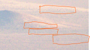
Prior to the release , the director Luigi Venditelli had made comments that there would be something in the Doco , that showed what Bob Lazar said in 1989. Something Bob could never have known in 89

This seems to be these pics in the doco which show what is alleged to be the outlines of the S4 hangars on the side of a hill next to Papoose lake. In the documentary, Venditelli says that "all you have to do is play with the contrast, play with the levels in the image. And if you look carefully in this version here where the contrast has been changed, that as we zoom, look what we see... You see them [the S4 hangars] clearly right there."

1775201629465.png

1775201650363.png


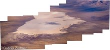
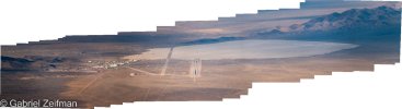
SignalIntelligence on Twitter seems to have tracked the source these images were derived from , the source being photo's taken by Gabriel Zeifman during fly pasts in April 7, 2020 and June 16, 2020. Two pics from this seem to be the likely source for what was used to create the above pics. Here are the likely Gabriel Zeifman source images and links to the source files


Source: drive.google.com/file/d/1Ic6NhgkK6nM43eeqSZSohLkrXop65jOv/view

Source: drive.google.com/file/d/1FEMZxdz3A7fEAYM8QrFSea9dD6675FDR/view


1775202086061.png

1775202121035.png


A person by the name of Scott Mitchell claims he is the source of the pics in the S4 Documentary, ie he is the one that grabbed the source image, did some contrasting and what ever else to create the pics used in the doco.

He eventually posted Part 1 of his Analysis Pack, a link to which is below. It has lots of images and files in a Zip.
The first image in the Zip titled "1. S4 - 0501 FULL Original Stock Image - PIC V1 (WiseBurger™).jpg" seems to be his source which he used to analyse and manipulate to create the pics used in the doco.
Source: https://www.mediafire.com/file/3yazfas6mqnq05c/S4_-_0501_Hanger_Doors_PACK_(WiseBurger™).zip/file

His Insta for ref: https://www.instagram.com/RealWiseBurger
Video where he confirms in the comments he was the one that analysed the pic: www.youtube.com/watch?v=GjPWtvYt7u8

Here is that pic:

1775202518375.png


It seems Scott Mitchell could be the same guy Corbell tweeted about in 2021 as being the source of Bob Lazar art he had received. See here:
Source: https://x.com/JeremyCorbell/status/1462102969197887489


It seems to me that you could look at those pics taken from a far and convince yourself of seeing hangars in a number of spots .


Thoughts?
 
Last edited:
lazarrrrr.png

In the documentary, Venditelli says that "all you have to do is play with the contrast, play with the levels in the image. And if you look carefully in this version here where the contrast has been changed, that as we zoom, look what we see... You see them [the S4 hangars] clearly right there.
Well, I had no trouble making the outlines of an entire city visible right next to it. :D
 
This seems to be these pics in the doco which show what is alleged to be the outlines of the S4 hangars on the side of a hill next to Papoose lake. In the documentary, Venditelli says that "all you have to do is play with the contrast, play with the levels in the image. And if you look carefully in this version here where the contrast has been changed, that as we zoom, look what we see... You see them [the S4 hangars] clearly right there."

1775201629465.png

gl.jpg


It's lucky that geological features can't ever have a (roughly) regular appearance, so they're never mistaken for man-made structures... :rolleyes:
Um, except the Giant's Causeway, the Bimini Road, "the Yonaguni Monument"...

Even if the indicated striations are actual features and were made by human activity, why should they be hangars?
It seems unlikely; there's no evidence of access roads, taxiways or runways. Of course, a flying saucer with some novel means of propulsion might be able to levitate and just fly out of an open hangar door, but without an access road or track it would be a bit of a trudge for the necessary personnel to get there. (Perhaps there are secret access tunnels. Or everything's moved in and out by camel train, or something).

The apparent lines might have been made (if they were man-made, which I doubt) for wholly different purposes, e.g. maybe demarcations on
some sort of gunnery target or instrument evaluation range. Maybe ground features deliberately made to mislead satellite photo interpreters in the service of potential adversaries.

And let's say, for the sake of argument, that these not particularly regularly-spaced lines, apparently of unequal lengths, are the sides of hangar doors or something like that: Well, Area 51 is a secret aerospace research facility, long established and well-resourced.
"Massive Cold War-era aircraft development base of strategic importance with billions of dollars of funding had hidden hangars/ bunkers" doesn't strike me as a particularly unlikely finding in itself, though it would be interesting. It's certainly something someone might have guessed at.
Someone working at Area 51 might have heard chatter- or just rumours- about hidden facilities if there were any. And perhaps if there weren't. But even if such facilities existed, which Mitchell/ Zeifman's photos/ Venditelli's conjectures emphatically don't demonstrate, that doesn't mean that Bob Lazar's claims that they contain extraterrestrial spacecraft are any more likely to be correct.

Has Venditelli, Mitchell, Zeifman or anyone else come up with estimates of the width of the "hangars"? -One or more of those guys presumably know the position of the hill or whatever it is, so estimating their scale should be reasonably straightforward (if the hill is on maps).
 
What an absurd basis for a claim.
Did they also show multiple satellite images of that location, perhaps from multiple dates and from different platforms owned by multiple companies and multiple nations?
both EO and radar images?
How about a topographic map of the location, to show how flat/steep the land is?
A door on a shallow slope would have to be many times longer/taller than it is wide to allow for an opening of any significant height.
Much easier to hide a 'hidden' door on a vertical or near vertical sloping surface.

Any signs of access roads to the site? How did the construction equipment and workers get to the location? Remove the material that was excavated from the site?
 
Bob Lazar and Luigi Venditelli were just on Rogan where Rogan mentions how his last episode with Lazar is his most viewed podcast on Youtube . Let's see how this goes.

Already, in the first 10 minutes I'm seeing complete BS. ie the Gimbal flies exactly like how Lazar described his sports model saucer flew.

New Rogan Lazar interview: www.youtube.com/watch?v=Lb_1d68vx-g
 
In the Rogan interview. Luigi says the source image (501) was analysed by his CGI guys who used Davinci to see those "Hangar;' outlines. He had use Davinci to look at other areas of the pic to see if the same pattern could be seen and they couldnt see it elsewhere
 
I took the effort to dedicate some of my time to listen to this Rogan episode. After one hour I stopped, as I couldn't stand Rogan's on and on ranting, which includes anti-vaccine talk. He is talking like a stoner who thinks he knows everything.
I actually felt more for Bob here, he sounded a tad more rational. But I cannot stand listening anymore, sorry.
 
Here's a Google Earth image of "a hill near Papoose Lake", and although I don't know which hill they're talking about, they're all much the same. Everything nearby drains into the dry lake bed (bottom of photo) and all the elevated areas are similar. It would appear that although it rains seldom in that desert area, the hills easily erode, and every area at every magnification seems to have downhill erosional gullies. The photo might be just a real potion of the terrain in which the gullies are quite regular (although the first three arrows in the original annotated photo, the ones with the dotted lines, https://www.metabunk.org/threads/s4-the-bob-lazar-story-evidence.14825/post-366325 , are purely imaginary, suggesting more regularity than the photo warrants).
IMG_3625.png
 
Last edited:
He is talking like a stoner who thinks he knows everything.

That's his whole shtick. I think he started the podcast as him and his buddy smoking weed and talking shit. It's shoptalk or man-cave talk. A bunch of dudes sitting around yacking.

Back in the mid '00s I shared a shop with a few other contractors and we would have FAATS (Friday afternoon at the Shop). We'd go hang out at the end of the week and shoot the shit about anything and everything. There was a keg in the fridge and a bottle of gin in the freezer. That's what his show is, that's its appeal. As such, despite all the misinformation he's always sharing and showcasing, I don't think he's quite as influential as some people fear. Yes, there's always true believers and for them, topics of their belief resonate. And there's always the credulous that will just believe anything. But I think most of the people I know that listen on a regular basis just think they're hanging out bull-shitting with Joe.

Few people, even in the UFO world, take Lazar seriously and some blurry photo isn't going to move the needle much. Even if Joe talks about it.
 
What an absurd basis for a claim.
Did they also show multiple satellite images of that location, perhaps from multiple dates and from different platforms owned by multiple companies and multiple nations?
both EO and radar images?
How about a topographic map of the location, to show how flat/steep the land is?
A door on a shallow slope would have to be many times longer/taller than it is wide to allow for an opening of any significant height.
Much easier to hide a 'hidden' door on a vertical or near vertical sloping surface.

Any signs of access roads to the site? How did the construction equipment and workers get to the location? Remove the material that was excavated from the site?
North road can be seen in the Northerly facing Pano of Papoose
 

Attachments

  • DSC_0761-Pano.jpg
    DSC_0761-Pano.jpg
    184.9 KB · Views: 1
Gabriel website had the full repository of Papoose lake and his flight around Nellis range. But the website is now gone, the full flight video and his channel have been removed by You tube. These are some of the images I saved from 2021.
 

Attachments

  • DSC_0761-Pano.jpg
    DSC_0761-Pano.jpg
    184.9 KB · Views: 1
  • area51Pano-1.jpg
    area51Pano-1.jpg
    98.1 KB · Views: 1
  • Screenshot 2026-04-04 at 9.09.34.png
    Screenshot 2026-04-04 at 9.09.34.png
    164.2 KB · Views: 1
Last edited by a moderator:
I have a strong impression the producers of the new doc/film approached it from the other direction. I.e. "we are almost done with the film, now we need a new thing to attract viewers! Can someone look in the noisy pictures for something interesting? wink wink wink"
 
Back
Top