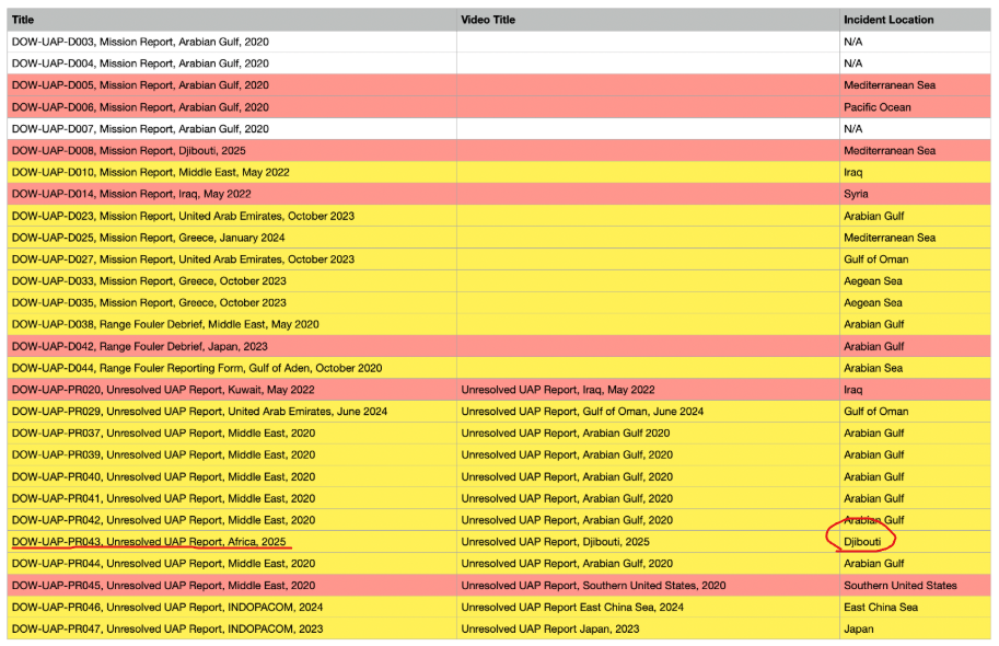
PR043 Africa - Djibouti

flarkey

Senior Member.
Staff member
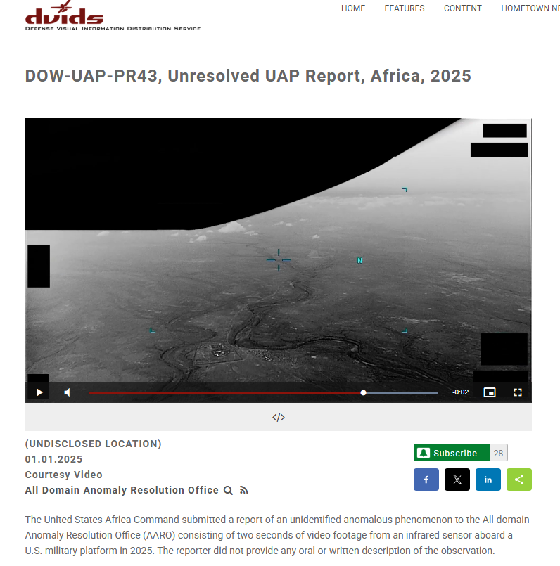
https://www.dvidshub.net/video/1006159/dow-uap-pr43-unresolved-uap-report-africa-2025


Video Description:00:00-00:02: A small, barely distinguishable area of contrast moves from the left side of the sensor field-of-view to the right side, exiting the scene from the bottom right quarter of the screen.

1778654119238.png

1778657293828.png


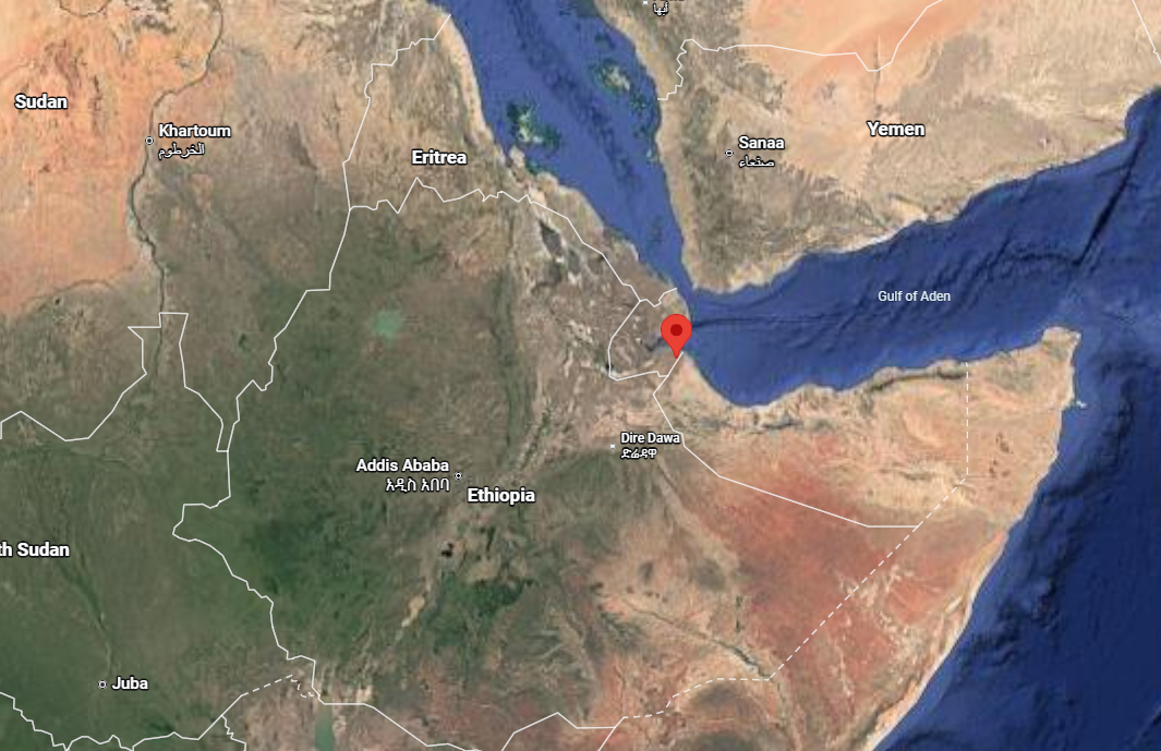
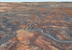
Djibouti....
1778657136541.png


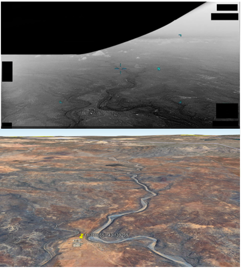
11.388655° 43.139259°
1778654324853.png
 

Attachments

  • 1778654217569.png
    1778654217569.png
    1.6 MB · Views: 41
Last edited:
They should recognize that if there's an identifiable feature in the video, then it's the same as giving the location. While geolocating is fun, they should really just unredact the lat/lon.
This may become a test of how really interested Congress is these videos being released.
If I was in Congress I would demand that they repeat this exercise and NOT obscure the geographic coordinates.
Some things like airspeed and altitude might, in some cases, be classified but when analysis of the image can reveal the location you are just being obnoxious by blocking geographic coordinates.
 
They should recognize that if there's an identifiable feature in the video, then it's the same as giving the location. While geolocating is fun, they should really just unredact the lat/lon.
In most of the Mission Reports and Range Foulers (some of them related to the videos), the MGRS coordinates are provided.
 
It's the US Military If its the rules that's what they will do, if the book says obscure everything they obscure everything, even if the Eiffel Tower is present in the video.
 
Article:
Together with my brilliant postdoc and council member, Dr. Devesh Nandal, we realized that unknown UAP parameters can be tightly constrained through a known background terrain, which can be used as a coordinate system to infer the motions of the target object as well as the camera, as functions of time.

To demonstrate the remarkable power of this method, we studied the declassified case DOW-UAP-PR043, involving an unresolved UAP report from Africa in 2025, released by the All-Domain Anomaly Resolution Office (AARO) in the Pentagon here. Amazingly, we were able to do better than AARO and resolve this case as a likely fast missile. Our full analysis report is available here. Below are some details of the related scientific analysis.


This one looked exactly like your standard zip-by from parallax and motion blur, but they seem to lean heavily towards "missile"

Time for some Sitrec!
 

Attachments

This one looked exactly like your standard zip-by from parallax and motion blur, but they seem to lean heavily towards "missile"
I always admire a good video that I can watch three times and not see the UAP. I admire, also, those of you who can pry these things apart and actually learn something about them!

QUESTION: Is it possible/probable that Dr. Loeb has access to information that we don't have that might inform him that there is a likelihood of a missile or two flying about there/then?
 
It looks to me that the small moving bright feature is first visible moving from approx. the area within the yellow ellipse,

d1.jpg


This might be a silly question, but why doesn't the "Detected target path" shown in Nandal and Loeb's "Terrain-stabilized target track" picture start at roughly this location?

1_M70_PGUAo0sX_0VEbIjZCw.webp

Accompanying text reads,
External Quote:
Terrain-stabilized target track. The red circles mark the 13 measured target centroids from frame 61 to frame 73, and the yellow line shows the fitted direction of motion. The target moves toward the lower right. The small frame-to-frame departures from the line are minor compared with the total track length and are consistent with centroid and image-processing uncertainty. (Image credit: Nandal & Loeb 2026
From "The Declassified DOW-UAP-PR043 in the PURSUE Disclosure is Likely a Missile", Avi Loeb, "Medium" website, 06 August 2026.
link as per Mick's post #6 (Apologies, I couldn't post the URL here without an annoying chunk of that webpage being visible in the post).

Is it because they couldn't establish a terrain-stabilized path before the f61 location, or some other reason?
 
It looks to me that the small moving bright feature is first visible moving from approx. the area within the yellow ellipse,

View attachment 92534

This might be a silly question, but why doesn't the "Detected target path" shown in Nandal and Loeb's "Terrain-stabilized target track" picture start at roughly this location?
...
Is it because they couldn't establish a terrain-stabilized path before the f61 location, or some other reason?
I suspect neither of them is a trained observer.
 
External Quote:
We also built a conditional camera model. The internal best-fit horizontal field of view was 65.6◦,
with a 5% score band from 60.4◦ to 71.0◦.
Under this model, the sensor altitude was 2.26 km
That's interesting because the largest hfov for the mts-b is 45°.
 
Is it possible/probable that Dr. Loeb has access to information that we don't have that might inform him that there is a likelihood of a missile or two flying about there/then?

I think the location in the video includes a small military outpost or base of some sort, approx. 1600 metres / 1 mile from where the moving feature is first seen.
It doesn't look like the moving object is aimed at the (possible) outpost.

dj2 flark.jpg


djib 1.jpg


djib 3.jpg


The Djiboutian army has a few dozen Humvees, Wikipedia https://en.wikipedia.org/wiki/List_of_equipment_of_the_Djiboutian_Army
More possible Humvee-type vehicles elsewhere in the compound.

dj6.jpg


In addition there's a US Navy base in Djibouti, Camp Lemonnier (Wikipedia https://en.wikipedia.org/wiki/Camp_Lemonnier).
This is at 11°32′37″N 43°08′55″E, less than 20 km approx. north from the compound at 11°23'19.2"N 43°08'21.3"E.
No idea if there might be any connection between the two.

dj7.jpg


I'd guess the compound is a military outpost, and this might increase the chance that the moving object is a projectile of some sort.
Even in peacetime, many armed forces fire missiles/ rockets, sometimes to test systems but perhaps more often (particularly with smaller infantry weapons) to provide familiarization for those who might be required to use them.
 
Last edited:
I'd guess the compound is a military outpost, and this might increase the chance that the moving object is a projectile of some sort.
Even in peacetime, many armed forces fire missiles/ rockets, sometimes to test systems but perhaps more often (particularly with smaller infantry weapons) to provide familiarization for those who might be required to use them.
The Compound nearby is or was a military outpost, controlled entry points with guard towers, painted rocks to keep soldiers from driving over the commanders cactus garden, that sort of thing, as of the 6/6/2023 Google Earth photo.

Some sort of missile fired in training? I would assume that nobody there would be shooting at US drones.

Do the analyses assume horizontal flight path for the object? Did any try to fit a ballistic trajectory to that short bit, or is it too brief? Thinking unguided artillery rocket.
 
Do the analyses assume horizontal flight path for the object?
Yes. Height is considered as a constant parameter.
Did any try to fit a ballistic trajectory to that short bit, or is it too brief?
They try to fit the speed to a quadratic equation but have to dismiss it as inconclusive because the estimates vary widely. The trajectory bit is to short to distinguish clearly between propelled and ballistic trajectory.
External Quote:
The short track does not show statistically significant acceleration or deceleration, so it cannot distinguish a powered missile from a sufficiently high ballistic-coefficient object that is coasting.
 
Your fov (~30°) is closer to existing mts-b fovs than theirs (~65°). Could you try with the wide 34° vfov?

NB : Your sitrec link doesn't work, did you use your dev env? It looks like changing it to https://metabunk.org/sitrec/?custom=99999999/PR043 Video Match/20260807_223139.js works.
Yeah sorry, I had to add some new code, and I was in dev when I shared that.

The new code is a very accurate view-fitting algorithm that calculates the actual camera position and FOV.

1786214250253.png


VFOV is a hair under 33°, HFOV is 55°

Significantly, the camera altitude is 1578m MSL. They incorrectly have it at 2260m AGL, which is a bit unfortunate considering Avi's boast of "the remarkable power of this method"

This was pretty obvious just from looking at their 3D match, which does not match
1786215171329.png


That invalidates all the numbers that follow in their paper, rendering it GIGO.
 
Yeah sorry, I had to add some new code, and I was in dev when I shared that.

The new code is a very accurate view-fitting algorithm that calculates the actual camera position and FOV.

View attachment 92550

VFOV is a hair under 33°, HFOV is 55°

Significantly, the camera altitude is 1578m MSL. They incorrectly have it at 2260m AGL, which is a bit unfortunate considering Avi's boast of "the remarkable power of this method"

This was pretty obvious just from looking at their 3D match, which does not match
View attachment 92551

That invalidates all the numbers that follow in their paper, rendering it GIGO.
Does this work with 3D buildings for ground based stuff?
 
I'm still struggling with sitrec so can't show it properly but I think the lines of sight to the object would "almost cross", as in they would cross seen from the side but are not actually in the same plane. This would mean there is a "slow object solution" where the object speed is orthogonal to the drone speed. This does not appear at all in Loeb's paper, but we've seen similar situations multiple times. It would totally undermine the missile hypothesis and what's left of the paper after the incorrect camera matching.
I don't know if I'll have time to back this hunch with data in the next few days so I wanted the idea to be out in the open if case someone else wants to take a look.
 
Last edited:
I'm still struggling with sitrec so can't show it properly but I think the lines of sight to the object would "almost cross", as in they would cross seen from the side but are not actually in the same plane. This would mean there is a "slow object solution" where the object speed is orthogonal to the drone speed. This does not appear at all in Loeb's paper, but we've seen similar situations multiple times. It would totally undermine the missile hypothesis and what's left of the paper after the incorrect camera matching.
I don't know if I'll have time to back this hunch with data in the next few days so I wanted the idea to be out in the open if case someone else wants to take a look.
It's a fiddly case, as the motion of the platform (aka the sensor, aka the drone) is hidden somewhat by vertical changes in the camera angle, possibly from the slight left/right banking. The motion is rather small and difficult to track. I think I'll try doing the point-tracking keyframes...
 
When we found the (probable) military compound at 11.388655° 43.139259° I thought it was likely part of the explanation and sort of lost a bit of interest.
Some troops from there had moved a short distance to the west and fired something approx. ENE. Where we can first see the object would have been very close to the point on the ground from where it had been launched/ fired.

But the object appears to cross (very, very roughly) approx. 2.5 km in the horizontal plane in something less than 2 seconds.
If it were something fired from the ground, the shortest path it could take would be a straight(ish) line essentially parallel to the ground, minimum speed would be in the region of 1250 m/s. That's 4500 kph, 2796 mph, Mach 3.673.
If there were a significant upward element to the flightpath, the distance covered would be greater and speed would have to be higher.

The Djibouti army probably doesn't have anything that could reach this speed (Wikipedia https://en.wikipedia.org/wiki/List_of_equipment_of_the_Djiboutian_Army)
Contemporary tank cannon can have muzzle velocities in the 1600 - 1750 m/s range, but projectile velocity drops during flight* and Djibouti doesn't have tanks. Maybe the cannon of its (three) WMA301 vehicles are in the 1400-1500 m/s region but again velocity would drop in flight (and they might be lower-pressure, lower velocity variants of the gun they were derived from- if not, these might be the only halfway plausible Djiboutian candidates).

The Djibouti army's artillery have lower muzzle velocities; D-30 guns around 700 m/s, M109L SPGs maybe approx. 810 m/s (Rheinmetal, 155mm Modular Charge System, https://www.rheinmetall.com/Rheinmetall Group/brochure-download/Weapon-Ammmunition/B284e0920-155mm-artillery-modular-charge-system.pdf).

Some surface-to-air missiles can reach/ exceed the mystery object's speed; most US Patriot missiles 1190 m/s, a recent variant 1887 m's in a test; Soviet/ Russian SA-300 and successors 2000 m/s and higher. But these are large systems, and Djibouti doesn't possess anything like this.
Smaller man-portable SAMs are slower (FIM-92 Stinger approx. Mach 2.2; Shorts Starstreak might be the fastest, >Mach 3); not fast enough for our mystery object (and none known in Djiboutian service).

I now think the presence of the military compound is a coincidence (though maybe it had something to do with there being a US aircraft monitoring the area). Back to considering a small object much closer to the camera.


*I can't tell by eye whether the object's apparent speed changes or not, does anyone know?
 
Last edited:
*I can't tell by eye whether the object's apparent speed changes or not, does anyone know?
Not that I can tell.

Since it's essentially linear motion for both the drone and the object, there's an infinite number of solutions. But if we restrict it to ones where the object maintains level altitude, then there's just a narrow range with it going around 21knots.

I got this from adding keyframes to the point fits, which won't ship for a while, as it's got at least an hour of tests to run, being a complex feature.
 
I got this from adding keyframes to the point fits, which won't ship for a while, as it's got at least an hour of tests to run, being a complex feature.
I just saw your video about it on twitter. That's exactly what I had in mind, thank you for looking into it.

Source: https://x.com/MickWest/status/2086589734848168249


They dismissed parallax without showing any work (this is the only mention of parallax I the entire paper) but in the end it's exactly what was missing from their model.
External Quote:
We then tested differential parallax. A stationary object at low altitude produced only a small fraction of the observed motion. The parallax contribution increased rapidly only when the assumed target altitude approached the conditional sensor altitude.
 
Back in May I geolocated this video to the following coordinates. This wasn't an attempt to be very accurate, just to get the general region of the river in Djibouti, and I picked a point at random near the military camp to give a clickable link in Google Maps. (see post #1 above)


In their Medium article and paper Avi and his team document the method they used to geolocate the location and provide the coordinates they used to start the analysis:


Source: https://avi-loeb.medium.com/the-declassified-dow-uap-pr043-in-the-pursue-disclosure-is-likely-a-missile-4d4116776c85

Lets compare:

Quite a coincidence that they picked exactly the same coordinates. So how much of a coincidence -

Copilot AI Question and answer:

So of all the points near that military camp they picked the same 11cm square that I did. o_O

Conclusions:

1) Avi's team read Metabunk
2) They don't give credit when referencing other people's work.

Speculation:
1) The methods they declared for Geolocation in their report are not accurate
2) The use of this data verges on plagiarism.

Copilot: is it plagiarism to use data collected by others without giving credit?
 
Last edited:
So of all the points near that military camp they picked the same 11cm square that I did. o_O

Conclusions:

1) Avi's team read Metabunk
2) They don't give credit when referencing other people's work.

Speculation:
1) The methods they declared for Geolocation in their report are not accurate
2) The use of this data verges on plagiarism.

I briefly wondered if they might have done this, but thought to myself "nah, they wouldn't", and never checked.

Not a good look for them!
 
1) Avi's team read Metabunk
2) They don't give credit when referencing other people's work.

They did not do very much original work I suspect.


In this document they write, in reference to the drainage feature:
"It resembles a river in the infrared image, but is more likely a dry wadi".
If they had actually look at another image source, like Google Earth, they would have directly observed that it is in fact a dry wadi. There would be no "is more likely" phrase. Sounds like they did not ever bother to check, so where did that amazingly similar set of coordinates come from, if not from copying Metabunk?
 
Back
Top